Kentucky
Covington, Kentucky
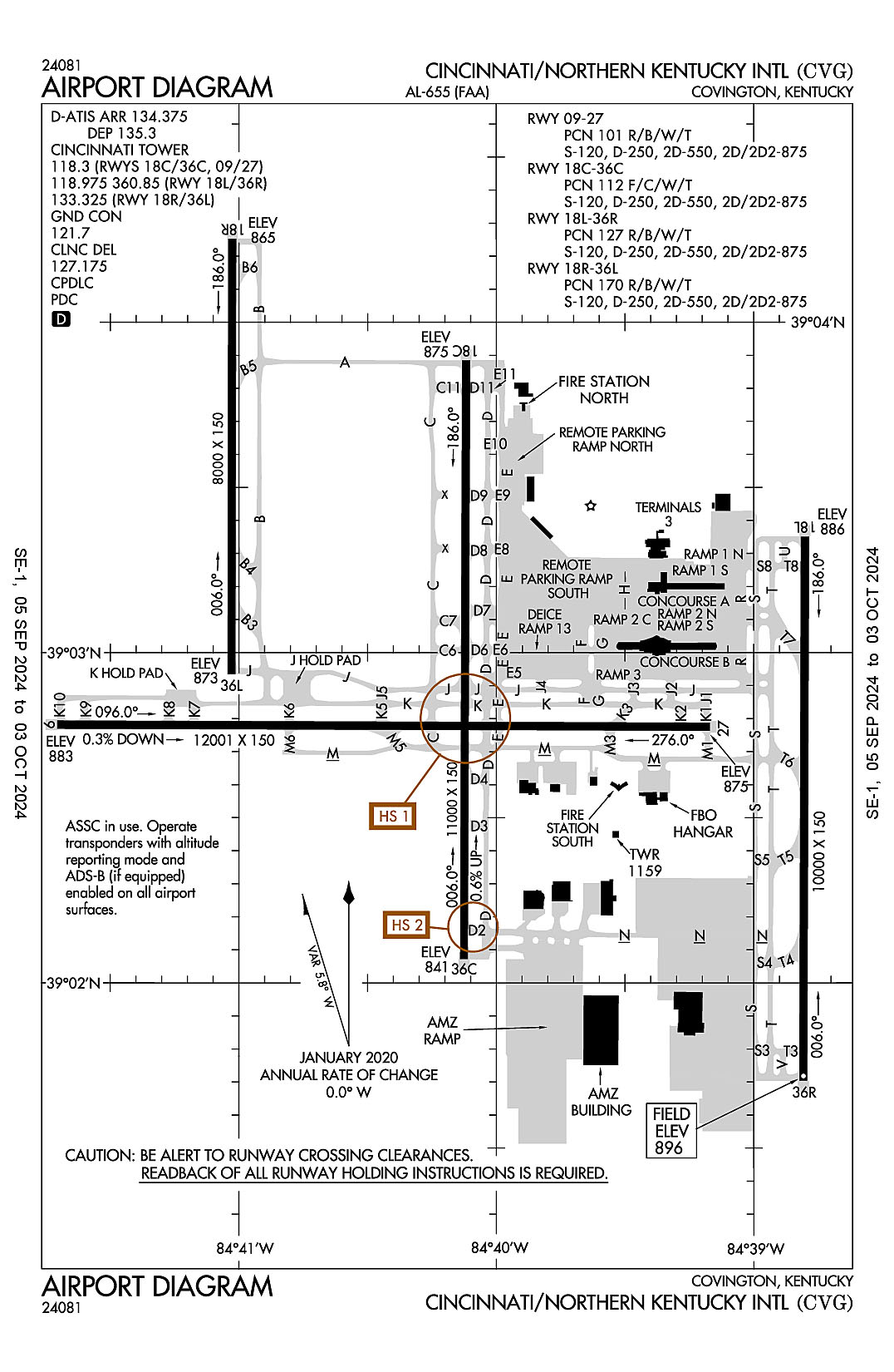
Cincinnati/Northern Kentucky International
ICAO Identifier KCVG
Covington, KY
Cincinnati/Northern Kentucky Intl
ICAO Identifier KCVG
AD 2.2 Aerodrome Geographical and Administrative Data
2.2.1 Reference Point: 39-02-55.815N / 84-40-04.155W
2.2.2 From City: 8 miles SW of COVINGTON, KY
2.2.3 Elevation: 896.1 ft
2.2.5 Magnetic Variation: 6W (2025)
2.2.6 Airport Contact: CANDACE MCGRAW
PO BOX 752000
CINCINNATI, OH 45275 (859-767-3151)
2.2.7 Traffic: IFR/VFR
AD 2.3 Attendance Schedule
2.3.1 All Months, All Days, All Hours
AD 2.4 Handling Services and Facilities
2.4.1 Cargo Handling Facilities: YES
2.4.2 Fuel Types: 100LL A
2.4.5 Hangar Space: YES
2.4.6 Repair Facilities: MAJOR
AD 2.6 Rescue and Firefighting Services
2.6.1 Aerodrome Category: Class-I certified on 5/1/1973
2.6.2 Rescue and Firefighting Services: ARFF Index-C
AD 2.12 Runway Physical Characteristics
2.12.1 Designation: 09
2.12.2 True Bearing: 90
2.12.3 True Dimensions: 12001 ft x 150 ft
2.12.4 PCN: 101 R/B/W/T
2.12.5 Coordinates: 39-02-46.9049N / 84-41-42.3534W
2.12.6 Threshold Elevation: 883.3
2.12.6 Touchdown Zone Elevation: 883.3
2.12.1 Designation: 27
2.12.2 True Bearing: 270
2.12.3 True Dimensions: 12001 ft x 150 ft
2.12.4 PCN: 101 R/B/W/T
2.12.5 Coordinates: 39-02-46.541N / 84-39-10.2439W
2.12.6 Threshold Elevation: 875
2.12.6 Touchdown Zone Elevation: 875
2.12.1 Designation: 36C
2.12.2 True Bearing: 0
2.12.3 True Dimensions: 11000 ft x 150 ft
2.12.4 PCN: 112 F/C/W/T
2.12.5 Coordinates: 39-02-04.3552N / 84-40-07.4709W
2.12.6 Threshold Elevation: 840.7
2.12.6 Touchdown Zone Elevation: 850.3
2.12.1 Designation: 18C
2.12.2 True Bearing: 180
2.12.3 True Dimensions: 11000 ft x 150 ft
2.12.4 PCN: 112 F/C/W/T
2.12.5 Coordinates: 39-03-53.0734N / 84-40-07.0233W
2.12.6 Threshold Elevation: 874.6
2.12.6 Touchdown Zone Elevation: 874.6
2.12.1 Designation: 18L
2.12.2 True Bearing: 180
2.12.3 True Dimensions: 10000 ft x 150 ft
2.12.4 PCN: 127 R/B/W/T
2.12.5 Coordinates: 39-03-21.0781N / 84-38-48.0048W
2.12.6 Threshold Elevation: 886.3
2.12.6 Touchdown Zone Elevation: 889.1
2.12.1 Designation: 36R
2.12.2 True Bearing: 0
2.12.3 True Dimensions: 10000 ft x 150 ft
2.12.4 PCN: 127 R/B/W/T
2.12.5 Coordinates: 39-01-42.2406N / 84-38-48.4562W
2.12.6 Threshold Elevation: 896.1
2.12.6 Touchdown Zone Elevation: 896.1
2.12.1 Designation: 18R
2.12.2 True Bearing: 180
2.12.3 True Dimensions: 8000 ft x 150 ft
2.12.4 PCN: 170 R/B/W/T
2.12.5 Coordinates: 39-04-15.1736N / 84-41-01.4552W
2.12.6 Threshold Elevation: 864.7
2.12.6 Touchdown Zone Elevation: 867.8
2.12.1 Designation: 36L
2.12.2 True Bearing: 0
2.12.3 True Dimensions: 8000 ft x 150 ft
2.12.4 PCN: 170 R/B/W/T
2.12.5 Coordinates: 39-02-56.1037N / 84-41-01.7608W
2.12.6 Threshold Elevation: 872.6
2.12.6 Touchdown Zone Elevation: 872.7
AD 2.13 Declared Distances
2.13.1 Designation: 09
2.13.2 Take-off Run Available: 12000
2.13.3 Take-off Distance Available: 12000
2.13.4 Accelerate-Stop Distance Available: 11640
2.13.5 Landing Distance Available: 11640
2.13.1 Designation: 27
2.13.2 Take-off Run Available: 12000
2.13.3 Take-off Distance Available: 12000
2.13.4 Accelerate-Stop Distance Available: 12000
2.13.5 Landing Distance Available: 12000
2.13.1 Designation: 36C
2.13.2 Take-off Run Available:
2.13.3 Take-off Distance Available:
2.13.4 Accelerate-Stop Distance Available:
2.13.5 Landing Distance Available:
2.13.1 Designation: 18C
2.13.2 Take-off Run Available:
2.13.3 Take-off Distance Available:
2.13.4 Accelerate-Stop Distance Available:
2.13.5 Landing Distance Available:
2.13.1 Designation: 18L
2.13.2 Take-off Run Available:
2.13.3 Take-off Distance Available:
2.13.4 Accelerate-Stop Distance Available:
2.13.5 Landing Distance Available:
2.13.1 Designation: 36R
2.13.2 Take-off Run Available:
2.13.3 Take-off Distance Available:
2.13.4 Accelerate-Stop Distance Available:
2.13.5 Landing Distance Available:
2.13.1 Designation: 18R
2.13.2 Take-off Run Available:
2.13.3 Take-off Distance Available:
2.13.4 Accelerate-Stop Distance Available:
2.13.5 Landing Distance Available:
2.13.1 Designation: 36L
2.13.2 Take-off Run Available:
2.13.3 Take-off Distance Available:
2.13.4 Accelerate-Stop Distance Available:
2.13.5 Landing Distance Available:
AD 2.14 Approach and Runway Lighting
2.14.1 Designation: 09
2.14.2 Approach Lighting System: MALSR
2.14.4 Visual Approach Slope Indicator System: P4L
2.14.1 Designation: 27
2.14.2 Approach Lighting System: MALSR
2.14.4 Visual Approach Slope Indicator System: P4L
2.14.1 Designation: 36C
2.14.2 Approach Lighting System: ALSF2
2.14.4 Visual Approach Slope Indicator System: P4L
2.14.1 Designation: 18C
2.14.2 Approach Lighting System: MALSR
2.14.4 Visual Approach Slope Indicator System: P4R
2.14.1 Designation: 18L
2.14.2 Approach Lighting System: MALSR
2.14.4 Visual Approach Slope Indicator System: P4L
2.14.1 Designation: 36R
2.14.2 Approach Lighting System: ALSF2
2.14.4 Visual Approach Slope Indicator System: P4R
2.14.1 Designation: 18R
2.14.2 Approach Lighting System: ALSF2
2.14.4 Visual Approach Slope Indicator System:
2.14.1 Designation: 36L
2.14.2 Approach Lighting System: ALSF2
2.14.4 Visual Approach Slope Indicator System:
AD 2.18 Air Traffic Services Communication Facilities
2.18.1 Service Designation: APCH/P (090-269)
2.18.3 Channel: 119.7
2.18.5 Hours of Operation: 24
2.18.1 Service Designation: APCH/P (270-089)
2.18.3 Channel: 123.875
2.18.5 Hours of Operation: 24
2.18.1 Service Designation: APCH/P
2.18.3 Channel: 363.15
2.18.5 Hours of Operation: 24
2.18.1 Service Designation: CD/P
2.18.3 Channel: 127.175
2.18.5 Hours of Operation: 24
2.18.1 Service Designation: CINCE STAR
2.18.3 Channel: 254.25
2.18.5 Hours of Operation: 24
2.18.1 Service Designation: CLASS B (001-180)
2.18.3 Channel: 121
2.18.5 Hours of Operation: 24
2.18.1 Service Designation: CLASS B (181-360)
2.18.3 Channel: 128.7
2.18.5 Hours of Operation: 24
2.18.1 Service Designation: CLASS B
2.18.3 Channel: 254.25
2.18.5 Hours of Operation: 24
2.18.1 Service Designation: D-ATIS (ARR)
2.18.3 Channel: 134.375
2.18.5 Hours of Operation: 24
2.18.1 Service Designation: D-ATIS (DEP)
2.18.3 Channel: 135.3
2.18.5 Hours of Operation: 24
2.18.1 Service Designation: DEP/P (001-180)
2.18.3 Channel: 126.65
2.18.5 Hours of Operation: 24
2.18.1 Service Designation: DEP/P (181-360)
2.18.3 Channel: 128.7
2.18.5 Hours of Operation: 24
2.18.1 Service Designation: DEP/P
2.18.3 Channel: 254.25
2.18.5 Hours of Operation: 24
2.18.1 Service Designation: EMERG
2.18.3 Channel: 121.5
2.18.5 Hours of Operation:
2.18.1 Service Designation: EMERG
2.18.3 Channel: 243
2.18.5 Hours of Operation:
2.18.1 Service Designation: GND/P
2.18.3 Channel: 121.7
2.18.5 Hours of Operation: 24
2.18.1 Service Designation: JAKIE STAR
2.18.3 Channel: 119.7
2.18.5 Hours of Operation: 24
2.18.1 Service Designation: JAKIE STAR
2.18.3 Channel: 254.25
2.18.5 Hours of Operation: 24
2.18.1 Service Designation: LCL/P (RWY 09/27, 18C/36C)
2.18.3 Channel: 118.3
2.18.5 Hours of Operation: 24
2.18.1 Service Designation: LCL/P (RWY 18L/36R)
2.18.3 Channel: 118.975
2.18.5 Hours of Operation: 24
2.18.1 Service Designation: LCL/P (RWY 18R/36L)
2.18.3 Channel: 133.325
2.18.5 Hours of Operation: 24
2.18.1 Service Designation: LCL/P (RWY 18L/36R)
2.18.3 Channel: 360.85
2.18.5 Hours of Operation: 24
AD 2.19 Radio Navigation and Landing Aids
2.19.1 ILS Type: DME for runway 09. Magnetic variation: 6W
2.19.2 ILS Identification: URN
2.19.5 Coordinates: 39-02-42.9147N / 84-39-02.0835W
2.19.6 Site Elevation: 886.8 ft
2.19.1 ILS Type: Glide Slop for runway 09. Magnetic variation: 6W
2.19.2 ILS Identification: URN
2.19.5 Coordinates: 39-02-42.9226N / 84-41-28.2646W
2.19.6 Site Elevation: 873.4 ft
2.19.1 ILS Type: Localizer for runway 09. Magnetic variation: 6W
2.19.2 ILS Identification: URN
2.19.5 Coordinates: 39-02-46.5213N / 84-39-02.0181W
2.19.6 Site Elevation: 877.4 ft
2.19.1 ILS Type: Glide Slop for runway 27. Magnetic variation: 6W
2.19.2 ILS Identification: JDP
2.19.5 Coordinates: 39-02-42.6295N / 84-39-25.1643W
2.19.6 Site Elevation: 866.4 ft
2.19.1 ILS Type: Localizer for runway 27. Magnetic variation: 6W
2.19.2 ILS Identification: JDP
2.19.5 Coordinates: 39-02-46.9321N / 84-41-55.3805W
2.19.6 Site Elevation: 883.3 ft
2.19.1 ILS Type: DME for runway 18C. Magnetic variation: 6W
2.19.2 ILS Identification: SIC
2.19.5 Coordinates: 39-01-54.1461N / 84-40-08.213W
2.19.6 Site Elevation: 843.6 ft
2.19.1 ILS Type: Glide Slop for runway 18C. Magnetic variation: 6W
2.19.2 ILS Identification: SIC
2.19.5 Coordinates: 39-03-42.6496N / 84-40-12.1363W
2.19.6 Site Elevation: 868 ft
2.19.1 ILS Type: Localizer for runway 18C. Magnetic variation: 6W
2.19.2 ILS Identification: SIC
2.19.5 Coordinates: 39-01-54.1433N / 84-40-07.5139W
2.19.6 Site Elevation: 838.2 ft
2.19.1 ILS Type: DME for runway 36C. Magnetic variation: 6W
2.19.2 ILS Identification: CVG
2.19.5 Coordinates: 39-04-03.9117N / 84-40-10.1702W
2.19.6 Site Elevation: 883 ft
2.19.1 ILS Type: Glide Slop for runway 36C. Magnetic variation: 6W
2.19.2 ILS Identification: CVG
2.19.5 Coordinates: 39-02-15.4827N / 84-40-12.493W
2.19.6 Site Elevation: 834.2 ft
2.19.1 ILS Type: Inner Marker for runway 36C. Magnetic variation: 6W
2.19.2 ILS Identification: CVG
2.19.5 Coordinates: 39-01-53.9241N / 84-40-07.5094W
2.19.6 Site Elevation: 818.2 ft
2.19.1 ILS Type: Localizer for runway 36C. Magnetic variation: 6W
2.19.2 ILS Identification: CVG
2.19.5 Coordinates: 39-04-03.6949N / 84-40-06.9785W
2.19.6 Site Elevation: 882.1 ft
2.19.1 ILS Type: DME for runway 18L. Magnetic variation: 6W
2.19.2 ILS Identification: CIZ
2.19.5 Coordinates: 39-01-31.5713N / 84-38-45.4036W
2.19.6 Site Elevation: 910.4 ft
2.19.1 ILS Type: Glide Slop for runway 18L. Magnetic variation: 6W
2.19.2 ILS Identification: CIZ
2.19.5 Coordinates: 39-03-10.8831N / 84-38-42.976W
2.19.6 Site Elevation: 881.2 ft
2.19.1 ILS Type: Localizer for runway 18L. Magnetic variation: 6W
2.19.2 ILS Identification: CIZ
2.19.5 Coordinates: 39-01-31.787N / 84-38-48.5019W
2.19.6 Site Elevation: 899 ft
2.19.1 ILS Type: DME for runway 36R. Magnetic variation: 6W
2.19.2 ILS Identification: EEI
2.19.5 Coordinates: 39-03-30.8826N / 84-38-51.18W
2.19.6 Site Elevation: 900.1 ft
2.19.1 ILS Type: Glide Slop for runway 36R. Magnetic variation: 6W
2.19.2 ILS Identification: EEI
2.19.5 Coordinates: 39-01-52.8044N / 84-38-43.3385W
2.19.6 Site Elevation: 889.9 ft
2.19.1 ILS Type: Inner Marker for runway 36R. Magnetic variation: 6W
2.19.2 ILS Identification: EEI
2.19.5 Coordinates: 39-01-33.5681N / 84-38-48.5005W
2.19.6 Site Elevation: 898.7 ft
2.19.1 ILS Type: Localizer for runway 36R. Magnetic variation: 6W
2.19.2 ILS Identification: EEI
2.19.5 Coordinates: 39-03-31.4843N / 84-38-47.9544W
2.19.6 Site Elevation: 892.1 ft
2.19.1 ILS Type: DME for runway 18R. Magnetic variation: 6W
2.19.2 ILS Identification: CJN
2.19.5 Coordinates: 39-02-41.52N / 84-41-05.2W
2.19.6 Site Elevation: 869 ft
2.19.1 ILS Type: Glide Slop for runway 18R. Magnetic variation: 6W
2.19.2 ILS Identification: CJN
2.19.5 Coordinates: 39-04-03.91N / 84-41-06.57W
2.19.6 Site Elevation: 860.5 ft
2.19.1 ILS Type: Inner Marker for runway 18R. Magnetic variation: 6W
2.19.2 ILS Identification: CJN
2.19.5 Coordinates: 39-04-23.57N / 84-41-01.42W
2.19.6 Site Elevation: 856 ft
2.19.1 ILS Type: Localizer for runway 18R. Magnetic variation: 6W
2.19.2 ILS Identification: CJN
2.19.5 Coordinates: 39-02-41.27N / 84-41-01.83W
2.19.6 Site Elevation: 871 ft
2.19.1 ILS Type: DME for runway 36L. Magnetic variation: 6W
2.19.2 ILS Identification: VAC
2.19.5 Coordinates: 39-04-25.0237N / 84-41-04.7924W
2.19.6 Site Elevation: 854.5 ft
2.19.1 ILS Type: Glide Slop for runway 36L. Magnetic variation: 6W
2.19.2 ILS Identification: VAC
2.19.5 Coordinates: 39-03-06.5542N / 84-41-06.7898W
2.19.6 Site Elevation: 865.8 ft
2.19.1 ILS Type: Inner Marker for runway 36L. Magnetic variation: 6W
2.19.2 ILS Identification: VAC
2.19.5 Coordinates: 39-02-44.323N / 84-41-01.8019W
2.19.6 Site Elevation: 868.2 ft
2.19.1 ILS Type: Localizer for runway 36L. Magnetic variation: 6W
2.19.2 ILS Identification: VAC
2.19.5 Coordinates: 39-04-25.5032N / 84-41-01.4165W
2.19.6 Site Elevation: 860.3 ft
2.19.1 Navigation Aid Type VORTAC. Magnetic variation: 4W
2.19.2 Navigation Aid Identification: CVG
2.19.5 Coordinates: 39-00-57.5308N / 84-42-12.0468W
2.19.6 Site Elevation: 878 ft
General Remarks:
SUCCESSIVE OR SIMUL DEP FM RWY 18L, 18C, 36L, 36C & 36R APVD WITH COURSE DVRG BGN NO FURTHER THAN 2 MI FM EOR DUE TO NOISE ABATEMENT.
TWYS RSTRD TO 15 MPH OR LESS WITH WINGSPAN 214 FT OR MORE.
NOISE SENS AREA N & S OF ARPT; RWY ASGN 2200-0700 BASED ON NOISE ABATEMENT.
BIRDS ON & INVOF THE ARPT.
RAMP CTL: RAMP 1N / 1S TXL & RAMP 2N / 2S TXL - 130.90, RAMP 3 TXL & N TXL - 130.375; DHL RAMP CTL: 129.475; AMZ RAMP CTL: 130.5.