Puerto Rico
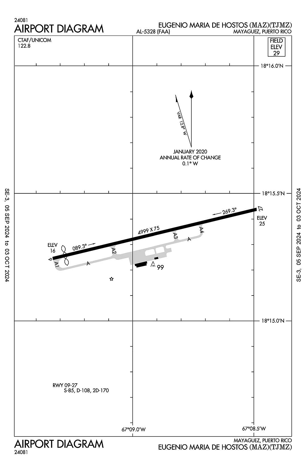
Mayaguez, Puerto Rico
Eugenio Maria De Hostos
ICAO Identifier TJMZ

Mayaguez, PR
Eugenio Maria De Hostos
ICAO Identifier TJMZ
AD 2.2 Aerodrome Geographical and Administrative Data
2.2.1 Reference Point: 18-15-20.47N / 67-08-54.498W
2.2.2 From City: 3 miles N of MAYAGUEZ, PR
2.2.3 Elevation: 28.7 ft
2.2.5 Magnetic Variation: 10W (1985)
2.2.6 Airport Contact: WILLIAM FEBLES
BOX 710
MAYAGUEZ, PR 681 (787-833-0148)
2.2.7 Traffic: IFR/VFR
AD 2.3 Attendance Schedule
2.3.1 All Months, MON-FRI Days, 0730-1600 Hours
AD 2.4 Handling Services and Facilities
2.4.1 Cargo Handling Facilities: NO
2.4.2 Fuel Types:
2.4.5 Hangar Space: NO
2.4.6 Repair Facilities: NONE
AD 2.6 Rescue and Firefighting Services
2.6.1 Aerodrome Category: None
2.6.2 Rescue and Firefighting Services: None
AD 2.12 Runway Physical Characteristics
2.12.1 Designation: 27
2.12.2 True Bearing: 256
2.12.3 True Dimensions: 4999 ft x 75 ft
2.12.4 PCN:
2.12.5 Coordinates: 18-15-26.2563N / 67-08-29.2895W
2.12.6 Threshold Elevation: 24.6
2.12.6 Touchdown Zone Elevation: 28.6
2.12.1 Designation: 09
2.12.2 True Bearing: 76
2.12.3 True Dimensions: 4999 ft x 75 ft
2.12.4 PCN:
2.12.5 Coordinates: 18-15-14.6859N / 67-09-19.7212W
2.12.6 Threshold Elevation: 16.2
2.12.6 Touchdown Zone Elevation: 28.6
AD 2.13 Declared Distances
2.13.1 Designation: 27
2.13.2 Take-off Run Available:
2.13.3 Take-off Distance Available:
2.13.4 Accelerate-Stop Distance Available:
2.13.5 Landing Distance Available:
2.13.1 Designation: 09
2.13.2 Take-off Run Available:
2.13.3 Take-off Distance Available:
2.13.4 Accelerate-Stop Distance Available:
2.13.5 Landing Distance Available:
AD 2.14 Approach and Runway Lighting
2.14.1 Designation: 27
2.14.2 Approach Lighting System:
2.14.4 Visual Approach Slope Indicator System: P4L
2.14.1 Designation: 09
2.14.2 Approach Lighting System:
2.14.4 Visual Approach Slope Indicator System: P4L
AD 2.18 Air Traffic Services Communication Facilities
AD 2.19 Radio Navigation and Landing Aids
2.19.1 Navigation Aid Type NDB. Magnetic variation: 10W
2.19.2 Navigation Aid Identification: MAZ
2.19.5 Coordinates: 18-15-13.529N / 67-09-08.947W
2.19.6 Site Elevation: ft
2.19.1 Navigation Aid Type VOR/DME. Magnetic variation: 10W
2.19.2 Navigation Aid Identification: MAZ
2.19.5 Coordinates: 18-15-23.2293N / 67-09-03.7215W
2.19.6 Site Elevation: 18 ft
General Remarks:
FOR CD IF FREQ ARE OTS CTC SAN JUAN CERAP AT 787-253-8664/8667
ULTRALIGHT ACTIVITY.
BIRDS ON AND INVOF ARPT.
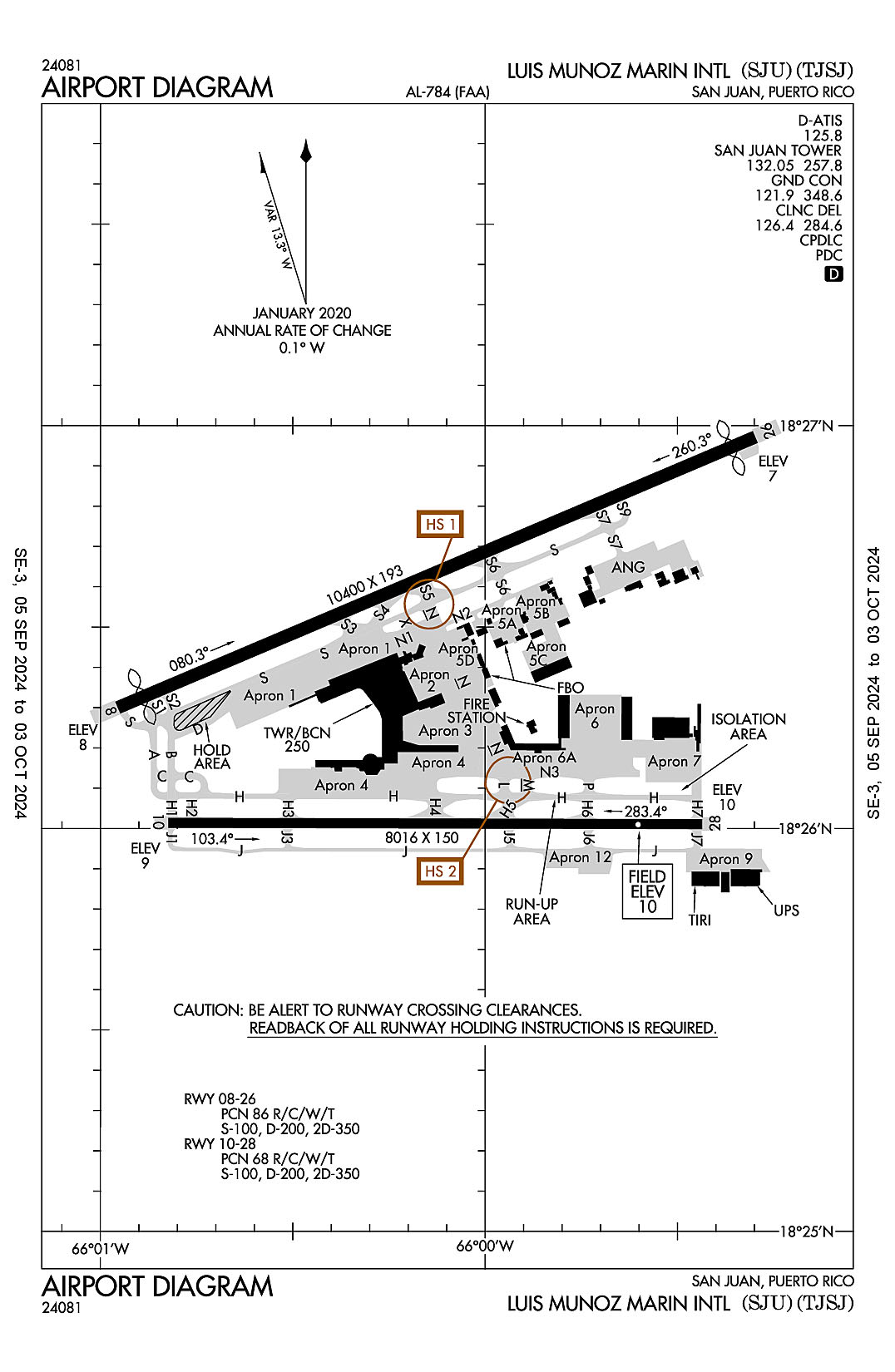
San Juan, Puerto Rico
Luis Munoz Marin International
ICAO Identifier TJSJ

San Juan, PR
Luis Munoz Marin Intl
ICAO Identifier TJSJ
AD 2.2 Aerodrome Geographical and Administrative Data
2.2.1 Reference Point: 18-26-21.837N / 66-00-07.68W
2.2.2 From City: 3 miles SE of SAN JUAN, PR
2.2.3 Elevation: 9.6 ft
2.2.5 Magnetic Variation: 11W (1985)
2.2.6 Airport Contact: MR. JORGE HERNANDEZ
P. O. BOX 38085
SAN JUAN, PR 937 ((787) 289-7240)
2.2.7 Traffic: IFR/VFR
AD 2.3 Attendance Schedule
2.3.1 All Months, All Days, All Hours
AD 2.4 Handling Services and Facilities
2.4.1 Cargo Handling Facilities: YES
2.4.2 Fuel Types: 100 A+ A++
2.4.5 Hangar Space: YES
2.4.6 Repair Facilities: MAJOR
AD 2.6 Rescue and Firefighting Services
2.6.1 Aerodrome Category: Class-I certified on 5/1/2005
2.6.2 Rescue and Firefighting Services: ARFF Index-D
AD 2.12 Runway Physical Characteristics
2.12.1 Designation: 08
2.12.2 True Bearing: 67
2.12.3 True Dimensions: 10400 ft x 193 ft
2.12.4 PCN: 86 R/C/W/T
2.12.5 Coordinates: 18-26-17.9673N / 66-00-57.3115W
2.12.6 Threshold Elevation: 8.2
2.12.6 Touchdown Zone Elevation: 9.3
2.12.1 Designation: 26
2.12.2 True Bearing: 247
2.12.3 True Dimensions: 10400 ft x 193 ft
2.12.4 PCN: 86 R/C/W/T
2.12.5 Coordinates: 18-26-58.2684N / 65-59-17.8783W
2.12.6 Threshold Elevation: 6.9
2.12.6 Touchdown Zone Elevation: 7.4
2.12.1 Designation: 10
2.12.2 True Bearing: 90
2.12.3 True Dimensions: 8016 ft x 150 ft
2.12.4 PCN: 68 R/C/W/T
2.12.5 Coordinates: 18-26-00.8092N / 66-00-49.4179W
2.12.6 Threshold Elevation: 9.3
2.12.6 Touchdown Zone Elevation: 9.3
2.12.1 Designation: 28
2.12.2 True Bearing: 270
2.12.3 True Dimensions: 8016 ft x 150 ft
2.12.4 PCN: 68 R/C/W/T
2.12.5 Coordinates: 18-26-00.6107N / 65-59-26.159W
2.12.6 Threshold Elevation: 9.5
2.12.6 Touchdown Zone Elevation: 9.6
AD 2.13 Declared Distances
2.13.1 Designation: 08
2.13.2 Take-off Run Available: 10400
2.13.3 Take-off Distance Available: 10400
2.13.4 Accelerate-Stop Distance Available: 9784
2.13.5 Landing Distance Available: 9384
2.13.1 Designation: 26
2.13.2 Take-off Run Available: 10400
2.13.3 Take-off Distance Available: 10400
2.13.4 Accelerate-Stop Distance Available: 10308
2.13.5 Landing Distance Available: 9908
2.13.1 Designation: 10
2.13.2 Take-off Run Available: 8016
2.13.3 Take-off Distance Available: 8016
2.13.4 Accelerate-Stop Distance Available: 8016
2.13.5 Landing Distance Available: 8016
2.13.1 Designation: 28
2.13.2 Take-off Run Available: 8016
2.13.3 Take-off Distance Available: 8016
2.13.4 Accelerate-Stop Distance Available: 8016
2.13.5 Landing Distance Available: 8016
AD 2.14 Approach and Runway Lighting
2.14.1 Designation: 08
2.14.2 Approach Lighting System: MALSR
2.14.4 Visual Approach Slope Indicator System: P4L
2.14.1 Designation: 26
2.14.2 Approach Lighting System:
2.14.4 Visual Approach Slope Indicator System:
2.14.1 Designation: 10
2.14.2 Approach Lighting System: MALSR
2.14.4 Visual Approach Slope Indicator System: P4L
2.14.1 Designation: 28
2.14.2 Approach Lighting System:
2.14.4 Visual Approach Slope Indicator System: P4L
AD 2.18 Air Traffic Services Communication Facilities
2.18.1 Service Designation: APCH/P DEP/P (WEST & SW)
2.18.3 Channel: 119.4
2.18.5 Hours of Operation: 24
2.18.1 Service Designation: APCH/P DEP/P (NORTH & EAST)
2.18.3 Channel: 120.9
2.18.5 Hours of Operation: 24
2.18.1 Service Designation: APCH/P DEP/P (WEST & SW)
2.18.3 Channel: 269.2
2.18.5 Hours of Operation: 24
2.18.1 Service Designation: APCH/P DEP/P (NORTH & EAST)
2.18.3 Channel: 290.2
2.18.5 Hours of Operation: 24
2.18.1 Service Designation: CD PRE TAXI CLNC
2.18.3 Channel: 126.4
2.18.5 Hours of Operation: 24
2.18.1 Service Designation: CD/P
2.18.3 Channel: 284.6
2.18.5 Hours of Operation: 24
2.18.1 Service Designation: CLASS C (WEST & SW)
2.18.3 Channel: 119.4
2.18.5 Hours of Operation: 24
2.18.1 Service Designation: CLASS C (NORTH & EAST)
2.18.3 Channel: 120.9
2.18.5 Hours of Operation: 24
2.18.1 Service Designation: CLASS C (WEST & SW)
2.18.3 Channel: 269.2
2.18.5 Hours of Operation: 24
2.18.1 Service Designation: CLASS C (NORTH & EAST)
2.18.3 Channel: 290.2
2.18.5 Hours of Operation: 24
2.18.1 Service Designation: COMD POST (PRANG COMD POST)
2.18.3 Channel: 235
2.18.5 Hours of Operation:
2.18.1 Service Designation: D-ATIS
2.18.3 Channel: 125.8
2.18.5 Hours of Operation: 24
2.18.1 Service Designation: EMERG
2.18.3 Channel: 121.5
2.18.5 Hours of Operation:
2.18.1 Service Designation: GND/P
2.18.3 Channel: 121.9
2.18.5 Hours of Operation: 24
2.18.1 Service Designation: GND/P
2.18.3 Channel: 348.6
2.18.5 Hours of Operation: 24
2.18.1 Service Designation: LCL/P
2.18.3 Channel: 132.05
2.18.5 Hours of Operation: 24
2.18.1 Service Designation: LCL/P
2.18.3 Channel: 257.8
2.18.5 Hours of Operation: 24
AD 2.19 Radio Navigation and Landing Aids
2.19.1 ILS Type: Glide Slop for runway 08. Magnetic variation: 11W
2.19.2 ILS Identification: SJU
2.19.5 Coordinates: 18-26-27.0397N / 66-00-45.5699W
2.19.6 Site Elevation: 4.2 ft
2.19.1 ILS Type: Localizer for runway 08. Magnetic variation: 11W
2.19.2 ILS Identification: SJU
2.19.5 Coordinates: 18-26-59.7947N / 65-59-14.1228W
2.19.6 Site Elevation: 5.6 ft
2.19.1 ILS Type: Outer Marker for runway 08. Magnetic variation: 11W
2.19.2 ILS Identification: SJU
2.19.5 Coordinates: 18-24-31.8227N / 66-05-21.8301W
2.19.6 Site Elevation: 66.5 ft
2.19.1 ILS Type: DME for runway 10. Magnetic variation: 11W
2.19.2 ILS Identification: CLA
2.19.5 Coordinates: 18-26-02.5352N / 65-59-15.6282W
2.19.6 Site Elevation: 18.2 ft
2.19.1 ILS Type: Glide Slop for runway 10. Magnetic variation: 11W
2.19.2 ILS Identification: CLA
2.19.5 Coordinates: 18-25-57.5628N / 66-00-39.041W
2.19.6 Site Elevation: 4.5 ft
2.19.1 ILS Type: Localizer for runway 10. Magnetic variation: 11W
2.19.2 ILS Identification: CLA
2.19.5 Coordinates: 18-26-00.5899N / 65-59-15.5192W
2.19.6 Site Elevation: 9 ft
2.19.1 Navigation Aid Type VORTAC. Magnetic variation: 11W
2.19.2 Navigation Aid Identification: SJU
2.19.5 Coordinates: 18-26-46.6101N / 65-59-22.2272W
2.19.6 Site Elevation: 5.7 ft
General Remarks:
TWY J BTN J1 AND J5 (NOT INCLUDING J5) CLSD TO ACFT WITH GREATER THAN 118 FT WINGSPAN.
ACFT 180 TURNS ON TWYS REQUIRES OPS COORDINATIONS.
FBO/GROUND HANDLER MUST SUBMIT 72 HRS PPR FOR ALL MIL ACFT TO: CCO@AEROSTARAIRPORTS.COM OR BY PHONE TO: 787-253-0979
MILITARY: ANG: INBD ACFT ORIGINATING FR OCONUS WITH A PPR FOR MUNIZ ANGB APN MUST CLEAR CUSTOMS AND BORDER PROTECTION AT CIV SIDE. PRIOR COORD MUST BE MADE WITH ANG AMOPS, FONE 740-9629 AT LEAST ONE BUS DAY PRIOR TO ARRIVAL.
ALL PVT AND CORPORATE AIRCRAFT MUST CONTACT ARPT OPS, BEFORE ARRIVAL, FOR FBOS & GROUND HANDLING INFO AT 787-253-0979.
ENGINE RUNUPS PROHIBITED ON GATES AREA.
APRON 12 AVBL FOR GA ACFT ONLY.
BASE OPS 1130-2000Z MON-FRI, CLSD WKEND AND HOL.