Connecticut
Windsor Locks, Connecticut
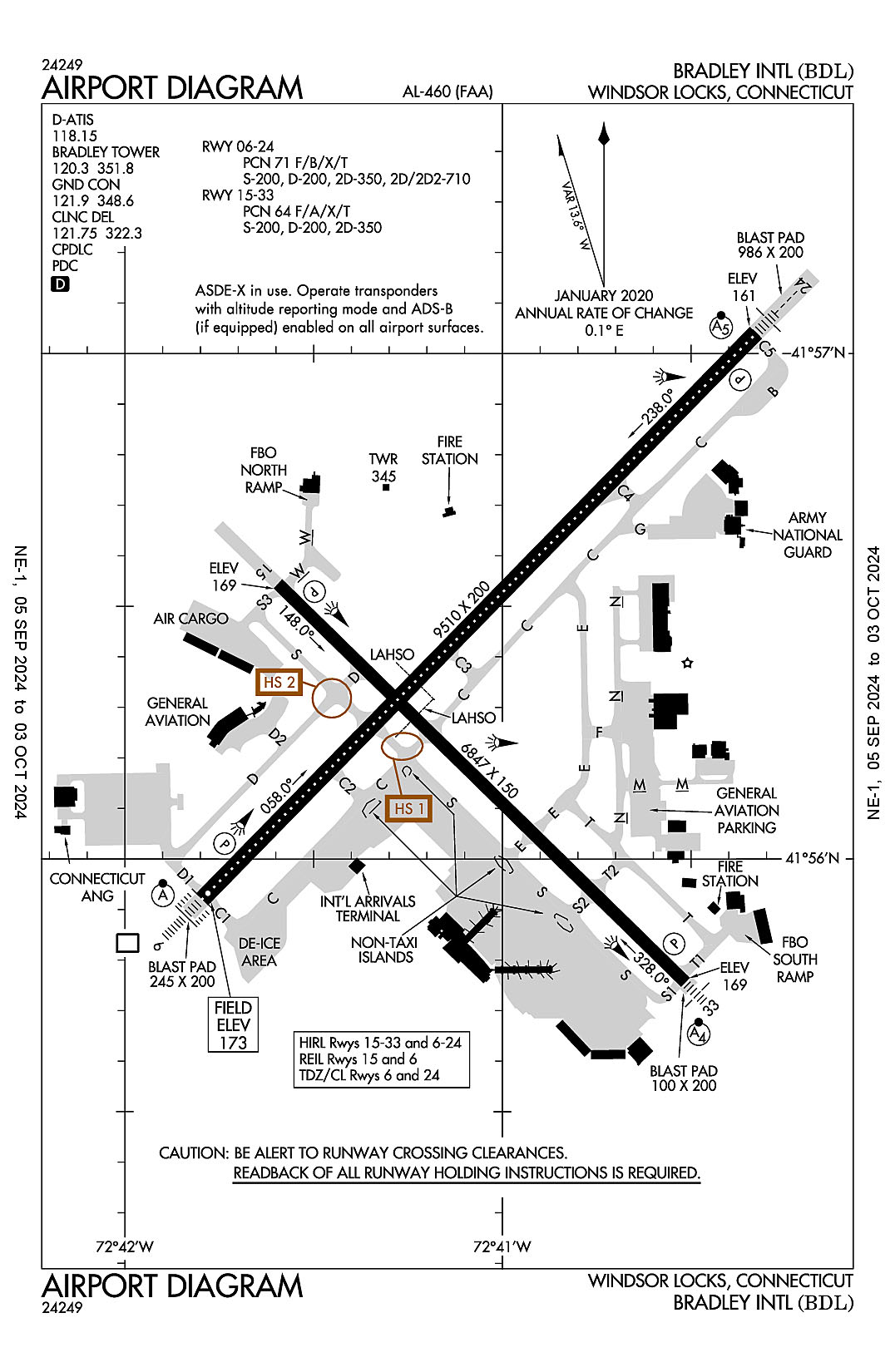
Bradley International
ICAO Identifier KBDL
Windsor Locks, CT
Bradley Intl
ICAO Identifier KBDL
AD 2.2 Aerodrome Geographical and Administrative Data
2.2.1 Reference Point: 41-56-20.516N / 72-41-03.537W
2.2.2 From City: 3 miles W of WINDSOR LOCKS, CT
2.2.3 Elevation: 173.3 ft
2.2.5 Magnetic Variation: 14W (1980)
2.2.6 Airport Contact: KEVIN DILLON, AAE
BRADLEY INTL AIRPORT
WINDSOR LOCKS, CT 6096 (860-292-2000)
2.2.7 Traffic: IFR/VFR
AD 2.3 Attendance Schedule
2.3.1 All Months, All Days, All Hours
AD 2.4 Handling Services and Facilities
2.4.1 Cargo Handling Facilities: YES
2.4.2 Fuel Types: 100LL A
2.4.5 Hangar Space: YES
2.4.6 Repair Facilities: MAJOR
AD 2.6 Rescue and Firefighting Services
2.6.1 Aerodrome Category: Class-I certified on 5/1/1973
2.6.2 Rescue and Firefighting Services: ARFF Index-C
AD 2.12 Runway Physical Characteristics
2.12.1 Designation: 06
2.12.2 True Bearing: 44
2.12.3 True Dimensions: 9510 ft x 200 ft
2.12.4 PCN: 71 F/B/X/T
2.12.5 Coordinates: 41-55-55.25N / 72-41-47.6885W
2.12.6 Threshold Elevation: 173
2.12.6 Touchdown Zone Elevation: 173.3
2.12.1 Designation: 24
2.12.2 True Bearing: 224
2.12.3 True Dimensions: 9510 ft x 200 ft
2.12.4 PCN: 71 F/B/X/T
2.12.5 Coordinates: 41-57-02.3952N / 72-40-19.6697W
2.12.6 Threshold Elevation: 160.9
2.12.6 Touchdown Zone Elevation: 170
2.12.1 Designation: 15
2.12.2 True Bearing: 134
2.12.3 True Dimensions: 6847 ft x 150 ft
2.12.4 PCN: 64 F/A/X/T
2.12.5 Coordinates: 41-56-32.6254N / 72-41-35.7104W
2.12.6 Threshold Elevation: 168.8
2.12.6 Touchdown Zone Elevation: 170.8
2.12.1 Designation: 33
2.12.2 True Bearing: 314
2.12.3 True Dimensions: 6847 ft x 150 ft
2.12.4 PCN: 64 F/A/X/T
2.12.5 Coordinates: 41-55-45.3238N / 72-40-30.9557W
2.12.6 Threshold Elevation: 168.5
2.12.6 Touchdown Zone Elevation: 171.4
AD 2.13 Declared Distances
2.13.1 Designation: 06
2.13.2 Take-off Run Available: 9509
2.13.3 Take-off Distance Available: 9509
2.13.4 Accelerate-Stop Distance Available: 9509
2.13.5 Landing Distance Available: 9509
2.13.1 Designation: 24
2.13.2 Take-off Run Available: 9509
2.13.3 Take-off Distance Available: 9509
2.13.4 Accelerate-Stop Distance Available: 9509
2.13.5 Landing Distance Available: 9509
2.13.1 Designation: 15
2.13.2 Take-off Run Available: 6847
2.13.3 Take-off Distance Available: 6847
2.13.4 Accelerate-Stop Distance Available: 6847
2.13.5 Landing Distance Available: 6847
2.13.1 Designation: 33
2.13.2 Take-off Run Available: 6847
2.13.3 Take-off Distance Available: 6847
2.13.4 Accelerate-Stop Distance Available: 6847
2.13.5 Landing Distance Available: 6847
AD 2.14 Approach and Runway Lighting
2.14.1 Designation: 06
2.14.2 Approach Lighting System: ALSF2
2.14.4 Visual Approach Slope Indicator System: P4L
2.14.1 Designation: 24
2.14.2 Approach Lighting System: MALSR
2.14.4 Visual Approach Slope Indicator System: P4L
2.14.1 Designation: 15
2.14.2 Approach Lighting System:
2.14.4 Visual Approach Slope Indicator System: P4L
2.14.1 Designation: 33
2.14.2 Approach Lighting System: MALSF
2.14.4 Visual Approach Slope Indicator System: P4R
AD 2.18 Air Traffic Services Communication Facilities
2.18.1 Service Designation: ANG OPS
2.18.3 Channel: 138.55
2.18.5 Hours of Operation:
2.18.1 Service Designation: ANG OPS
2.18.3 Channel: 349.7
2.18.5 Hours of Operation:
2.18.1 Service Designation: CD/P
2.18.3 Channel: 121.75
2.18.5 Hours of Operation: 24
2.18.1 Service Designation: CD/P
2.18.3 Channel: 322.3
2.18.5 Hours of Operation: 24
2.18.1 Service Designation: D-ATIS
2.18.3 Channel: 118.15
2.18.5 Hours of Operation: 24
2.18.1 Service Designation: EMERG
2.18.3 Channel: 121.5
2.18.5 Hours of Operation:
2.18.1 Service Designation: EMERG
2.18.3 Channel: 243
2.18.5 Hours of Operation:
2.18.1 Service Designation: GND/P
2.18.3 Channel: 121.9
2.18.5 Hours of Operation: 24
2.18.1 Service Designation: GND/P
2.18.3 Channel: 348.6
2.18.5 Hours of Operation: 24
2.18.1 Service Designation: LCL/P
2.18.3 Channel: 120.3
2.18.5 Hours of Operation: 24
2.18.1 Service Designation: LCL/P
2.18.3 Channel: 351.8
2.18.5 Hours of Operation: 24
2.18.1 Service Designation: NG OPS
2.18.3 Channel: 41.9
2.18.5 Hours of Operation:
2.18.1 Service Designation: NG OPS
2.18.3 Channel: 123.45
2.18.5 Hours of Operation:
2.18.1 Service Designation: NG OPS
2.18.3 Channel: 243.9
2.18.5 Hours of Operation:
AD 2.19 Radio Navigation and Landing Aids
2.19.1 ILS Type: DME for runway 06. Magnetic variation: 14W
2.19.2 ILS Identification: BDL
2.19.5 Coordinates: 41-57-17.2894N / 72-39-56.5118W
2.19.6 Site Elevation: 163.8 ft
2.19.1 ILS Type: Glide Slop for runway 06. Magnetic variation: 14W
2.19.2 ILS Identification: BDL
2.19.5 Coordinates: 41-56-05.5448N / 72-41-41.8869W
2.19.6 Site Elevation: 169.3 ft
2.19.1 ILS Type: Localizer for runway 06. Magnetic variation: 14W
2.19.2 ILS Identification: BDL
2.19.5 Coordinates: 41-57-17.8499N / 72-39-59.4045W
2.19.6 Site Elevation: 149.5 ft
2.19.1 ILS Type: DME for runway 24. Magnetic variation: 14W
2.19.2 ILS Identification: MYQ
2.19.5 Coordinates: 41-57-17.2894N / 72-39-56.5118W
2.19.6 Site Elevation: 163.8 ft
2.19.1 ILS Type: Glide Slop for runway 24. Magnetic variation: 14W
2.19.2 ILS Identification: MYQ
2.19.5 Coordinates: 41-56-53.5757N / 72-40-25.9626W
2.19.6 Site Elevation: 156.7 ft
2.19.1 ILS Type: Localizer for runway 24. Magnetic variation: 14W
2.19.2 ILS Identification: MYQ
2.19.5 Coordinates: 41-55-47.661N / 72-41-57.6296W
2.19.6 Site Elevation: 170.3 ft
2.19.1 ILS Type: DME for runway 33. Magnetic variation: 14W
2.19.2 ILS Identification: IKX
2.19.5 Coordinates: 41-56-37.9724N / 72-41-47.432W
2.19.6 Site Elevation: 181.8 ft
2.19.1 ILS Type: Glide Slop for runway 33. Magnetic variation: 14W
2.19.2 ILS Identification: IKX
2.19.5 Coordinates: 41-55-54.7672N / 72-40-38.5896W
2.19.6 Site Elevation: 167.6 ft
2.19.1 ILS Type: Localizer for runway 33. Magnetic variation: 14W
2.19.2 ILS Identification: IKX
2.19.5 Coordinates: 41-56-40.2961N / 72-41-46.2065W
2.19.6 Site Elevation: 168.3 ft
General Remarks:
TWY D CLSD BTN S & D1 TO ACFT WITH WING SPANS IN EXCESS OF 170 FT.
TWY C BTN TWY B & TWY C4 ACFT TAX SPD RSTRN OF 8 KTS/10 MPH MAX FOR ACFT WITH WINGSPAN 214 FT OR GTR.
LGTD OBST ANT 36 FT AGL/205 FT MSL (RWY 24 ILS/GS ANT) 162 FT NW OF TWY C CNTRLN MARKING BTN TWY B & TWY C4.
CAUTION: ANG RAMP MRK MAY NOT BE APPROPRIATE FOR LARGE ACFT: FLW MARSHALLERS INSTR.
OPS CTC AUTOVON 636-8385; COML 860-627-3001.
NMRS BIRDS FQTLY ON OR INVOF ARPT.
MILITARY: ANG: WHEN CKG ATIS, BIRDS IN VCY MAY INDC HEIGHTENED BIRD WATCH CONDITION (BWC). USAF ACFT CTC ANG AIRFIELD OPS ON UHF FOR CURRENT BWC & ANY ASSOCD RSTRNS.
MILITARY: ARNG - DSN 636-7519/7520. C860-292-4519/4520.
MILITARY: ANG: OG/CC WAIVER ON FILE FOR C-130H/J WITH OPR WT UP TO 155000 LB. ALL OTHER ACFT OVR ANG RAMP PCN RQR WAIVER FR OG/CC THRU AFLD MGMT.
MILITARY: ANG: AFLD MGR DOES NOT ISSUE OR STORE COMSEC FOR TRAN CREWS.
MILITARY: ANG: PPR V220-2356.
FUEL: A++ (MIL).
NON-BASED DVRSN ACRS CTC ARPT OPS 860-627-3001 PRIOR TO DIVG & PRVD CO FLT OPS CTC INFO, ACFT TYPE, POB, INTL OR DOM FLT & GND OPS AGRMTS. ONLY 1 INTL ACR JETBRIDGE AVBL FOR PAX.
MILITARY: ARNG: OPR 1200-2030Z++ MON, TUE, FRI; 1200-0400++ WED, THU. 41.9 149.825 335.775 (HAVOC OPS).
NO DE-ICING AVBL AT ANG.
RWY 6 DE-ICE PAD CLSD TO ACFT WITH WINGSPAN 171 FT OR GTR EXC WITH FOLLOW-ME ESCORT BY ARPT OPS.
NO TRNG FLTS, NO PLAS, NO TGLS BTN: 2300 - 0700 MON THRU SAT & 2300 - 1200 SUN.
FIXED WING ACFT USE LOW IDLE FOR TAXI, NO ENGINE CHECKS OR POWER RUNS ALLOWED ON THE ARNG RAMP DUE TO POSSIBLE FOD HAZARD.
MILITARY: ANG: OPR 1200-2030Z++ MON-FRI (SAT, SUN UNIT TRNG ASSEMBLY), CLSD HOL.
BASH PHASE II INCRD BIRD ACTVTY SEP-OCT AND MAR-APR.
PARL TWY OPS ON TWY C & TWY B RSTRD TO ACFT WITH WINGSPANS OF 171 FT OR LESS.
(E117) CT ANG AND U.S. ARMY NG.
MILITARY: ANG: NSTD WHITE GND EQPT BOXES PAINTED ON ANG RAMP.
ACFT REQG US CUST SVCS MUST PARK ON THE CUST SPOT W/ THE NOSE OF THE ACFT FACING SW. CTC CUST AT 860-292-1314 WHEN PARKED.