Arizona
Phoenix, Arizona
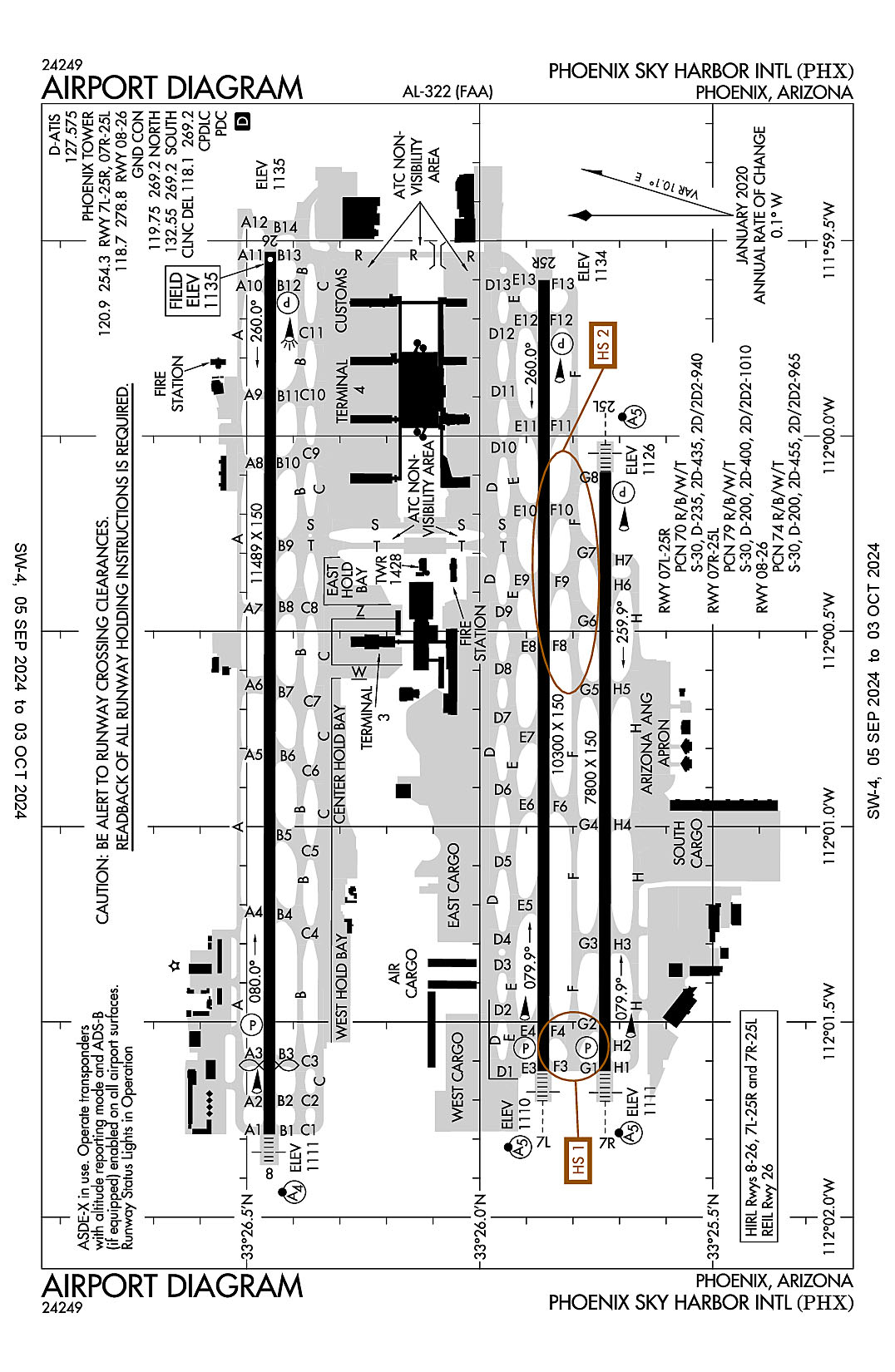
Phoenix Sky Harbor International
ICAO Identifier KPHX
Phoenix, AZ
Phoenix Sky Harbor Intl
ICAO Identifier KPHX
AD 2.2 Aerodrome Geographical and Administrative Data
2.2.1 Reference Point: 33-26-03.4N / 112-00-41.7W
2.2.2 From City: 3 miles E of PHOENIX, AZ
2.2.3 Elevation: 1134.8 ft
2.2.5 Magnetic Variation: 12E (2000)
2.2.6 Airport Contact: CHAD R. MAKOVSKY
2485 E BUCKEYE RD
PHOENIX, AZ 85034 (602-273-3302)
2.2.7 Traffic: IFR/VFR
AD 2.3 Attendance Schedule
2.3.1 All Months, All Days, All Hours
AD 2.4 Handling Services and Facilities
2.4.1 Cargo Handling Facilities: YES
2.4.2 Fuel Types: 100LL A
2.4.5 Hangar Space: YES
2.4.6 Repair Facilities: MAJOR
AD 2.6 Rescue and Firefighting Services
2.6.1 Aerodrome Category: Class-I certified on 5/1/1973
2.6.2 Rescue and Firefighting Services: ARFF Index-D
AD 2.12 Runway Physical Characteristics
2.12.1 Designation: 07L
2.12.2 True Bearing: 90
2.12.3 True Dimensions: 10300 ft x 150 ft
2.12.4 PCN: 70 R/B/W/T
2.12.5 Coordinates: 33-25-51.8081N / 112-01-37.5659W
2.12.6 Threshold Elevation: 1110.2
2.12.6 Touchdown Zone Elevation: 1116.5
2.12.1 Designation: 25R
2.12.2 True Bearing: 270
2.12.3 True Dimensions: 10300 ft x 150 ft
2.12.4 PCN: 70 R/B/W/T
2.12.5 Coordinates: 33-25-51.7284N / 111-59-36.0429W
2.12.6 Threshold Elevation: 1134
2.12.6 Touchdown Zone Elevation: 1134.1
2.12.1 Designation: 25L
2.12.2 True Bearing: 270
2.12.3 True Dimensions: 7800 ft x 150 ft
2.12.4 PCN: 79 R/B/W/T
2.12.5 Coordinates: 33-25-43.8354N / 112-00-05.5412W
2.12.6 Threshold Elevation: 1126.3
2.12.6 Touchdown Zone Elevation: 1126.4
2.12.1 Designation: 07R
2.12.2 True Bearing: 90
2.12.3 True Dimensions: 7800 ft x 150 ft
2.12.4 PCN: 79 R/B/W/T
2.12.5 Coordinates: 33-25-43.8923N / 112-01-37.5686W
2.12.6 Threshold Elevation: 1111
2.12.6 Touchdown Zone Elevation: 1115.9
2.12.1 Designation: 26
2.12.2 True Bearing: 270
2.12.3 True Dimensions: 11489 ft x 150 ft
2.12.4 PCN: 74 R/B/W/T
2.12.5 Coordinates: 33-26-26.9643N / 111-59-31.6884W
2.12.6 Threshold Elevation: 1134.7
2.12.6 Touchdown Zone Elevation: 1134.8
2.12.1 Designation: 08
2.12.2 True Bearing: 90
2.12.3 True Dimensions: 11489 ft x 150 ft
2.12.4 PCN: 74 R/B/W/T
2.12.5 Coordinates: 33-26-27.0993N / 112-01-47.257W
2.12.6 Threshold Elevation: 1111.1
2.12.6 Touchdown Zone Elevation: 1118
AD 2.13 Declared Distances
2.13.1 Designation: 07L
2.13.2 Take-off Run Available: 10300
2.13.3 Take-off Distance Available: 10300
2.13.4 Accelerate-Stop Distance Available: 10300
2.13.5 Landing Distance Available: 10300
2.13.1 Designation: 25R
2.13.2 Take-off Run Available: 10300
2.13.3 Take-off Distance Available: 10300
2.13.4 Accelerate-Stop Distance Available: 10300
2.13.5 Landing Distance Available: 10300
2.13.1 Designation: 25L
2.13.2 Take-off Run Available: 7800
2.13.3 Take-off Distance Available: 7800
2.13.4 Accelerate-Stop Distance Available: 7800
2.13.5 Landing Distance Available: 7800
2.13.1 Designation: 07R
2.13.2 Take-off Run Available: 7800
2.13.3 Take-off Distance Available: 7800
2.13.4 Accelerate-Stop Distance Available: 7800
2.13.5 Landing Distance Available: 7800
2.13.1 Designation: 26
2.13.2 Take-off Run Available: 11489
2.13.3 Take-off Distance Available: 11489
2.13.4 Accelerate-Stop Distance Available: 11489
2.13.5 Landing Distance Available: 11489
2.13.1 Designation: 08
2.13.2 Take-off Run Available: 11489
2.13.3 Take-off Distance Available: 11489
2.13.4 Accelerate-Stop Distance Available: 11489
2.13.5 Landing Distance Available: 10591
AD 2.14 Approach and Runway Lighting
2.14.1 Designation: 07L
2.14.2 Approach Lighting System: MALSR
2.14.4 Visual Approach Slope Indicator System: P4L
2.14.1 Designation: 25R
2.14.2 Approach Lighting System:
2.14.4 Visual Approach Slope Indicator System: P4L
2.14.1 Designation: 25L
2.14.2 Approach Lighting System: MALSR
2.14.4 Visual Approach Slope Indicator System: P4L
2.14.1 Designation: 07R
2.14.2 Approach Lighting System: MALSR
2.14.4 Visual Approach Slope Indicator System: P4L
2.14.1 Designation: 26
2.14.2 Approach Lighting System:
2.14.4 Visual Approach Slope Indicator System: P4L
2.14.1 Designation: 08
2.14.2 Approach Lighting System: MALSF
2.14.4 Visual Approach Slope Indicator System: P4L
AD 2.18 Air Traffic Services Communication Facilities
2.18.1 Service Designation: CD/P
2.18.3 Channel: 118.1
2.18.5 Hours of Operation: 24
2.18.1 Service Designation: CD/P
2.18.3 Channel: 269.2
2.18.5 Hours of Operation: 24
2.18.1 Service Designation: D-ATIS
2.18.3 Channel: 127.575
2.18.5 Hours of Operation: 24
2.18.1 Service Designation: EMERG
2.18.3 Channel: 243
2.18.5 Hours of Operation:
2.18.1 Service Designation: GND/P (NORTH)
2.18.3 Channel: 119.75
2.18.5 Hours of Operation: 24
2.18.1 Service Designation: GND/P (SOUTH)
2.18.3 Channel: 132.55
2.18.5 Hours of Operation: 24
2.18.1 Service Designation: GND/P
2.18.3 Channel: 269.2
2.18.5 Hours of Operation: 24
2.18.1 Service Designation: LCL/P (RWY 08/26)
2.18.3 Channel: 118.7
2.18.5 Hours of Operation: 24
2.18.1 Service Designation: LCL/P (RWY 07L/25R, 07R/25L)
2.18.3 Channel: 120.9
2.18.5 Hours of Operation: 24
2.18.1 Service Designation: LCL/P (RWY 07L/25R, 07R/25L)
2.18.3 Channel: 254.3
2.18.5 Hours of Operation: 24
2.18.1 Service Designation: LCL/P (RWY 08/26)
2.18.3 Channel: 278.8
2.18.5 Hours of Operation: 24
AD 2.19 Radio Navigation and Landing Aids
2.19.1 ILS Type: DME for runway 07L. Magnetic variation: 12E
2.19.2 ILS Identification: PHX
2.19.5 Coordinates: 33-25-54.0771N / 111-59-19.1054W
2.19.6 Site Elevation: 1143 ft
2.19.1 ILS Type: Glide Slop for runway 07L. Magnetic variation: 12E
2.19.2 ILS Identification: PHX
2.19.5 Coordinates: 33-25-49.0529N / 112-01-25.2134W
2.19.6 Site Elevation: 1106.5 ft
2.19.1 ILS Type: Localizer for runway 07L. Magnetic variation: 12E
2.19.2 ILS Identification: PHX
2.19.5 Coordinates: 33-25-51.7152N / 111-59-20.367W
2.19.6 Site Elevation: 1133.5 ft
2.19.1 ILS Type: DME for runway 07R. Magnetic variation: 12E
2.19.2 ILS Identification: AHA
2.19.5 Coordinates: 33-25-41.1847N / 111-59-52.1833W
2.19.6 Site Elevation: 1135.8 ft
2.19.1 ILS Type: Glide Slop for runway 07R. Magnetic variation: 12E
2.19.2 ILS Identification: AHA
2.19.5 Coordinates: 33-25-46.628N / 112-01-25.0931W
2.19.6 Site Elevation: 1107.4 ft
2.19.1 ILS Type: Localizer for runway 07R. Magnetic variation: 12E
2.19.2 ILS Identification: AHA
2.19.5 Coordinates: 33-25-43.8252N / 111-59-52.2902W
2.19.6 Site Elevation: 1124.2 ft
2.19.1 ILS Type: DME for runway 25L. Magnetic variation: 12E
2.19.2 ILS Identification: RJG
2.19.5 Coordinates: 33-25-41.1847N / 111-59-52.1833W
2.19.6 Site Elevation: 1117.1 ft
2.19.1 ILS Type: Glide Slop for runway 25L. Magnetic variation: 12E
2.19.2 ILS Identification: RJG
2.19.5 Coordinates: 33-25-40.9318N / 112-00-16.8722W
2.19.6 Site Elevation: 1120.3 ft
2.19.1 ILS Type: Localizer for runway 25L. Magnetic variation: 12E
2.19.2 ILS Identification: RJG
2.19.5 Coordinates: 33-25-43.8995N / 112-01-49.6368W
2.19.6 Site Elevation: 1103.2 ft
2.19.1 ILS Type: DME for runway 08. Magnetic variation: 12E
2.19.2 ILS Identification: SYQ
2.19.5 Coordinates: 33-26-24.3207N / 111-59-19.7057W
2.19.6 Site Elevation: 1149.2 ft
2.19.1 ILS Type: Glide Slop for runway 08. Magnetic variation: 12E
2.19.2 ILS Identification: SYQ
2.19.5 Coordinates: 33-26-29.6544N / 112-01-24.6276W
2.19.6 Site Elevation: 1111.7 ft
2.19.1 ILS Type: Localizer for runway 08. Magnetic variation: 12E
2.19.2 ILS Identification: SYQ
2.19.5 Coordinates: 33-26-26.9483N / 111-59-19.7443W
2.19.6 Site Elevation: 1134.1 ft
2.19.1 ILS Type: DME for runway 26. Magnetic variation: 12E
2.19.2 ILS Identification: CWJ
2.19.5 Coordinates: 33-26-24.3207N / 111-59-19.7057W
2.19.6 Site Elevation: 1149.2 ft
2.19.1 ILS Type: Glide Slop for runway 26. Magnetic variation: 12E
2.19.2 ILS Identification: CWJ
2.19.5 Coordinates: 33-26-29.603N / 111-59-44.4331W
2.19.6 Site Elevation: 1129.1 ft
2.19.1 ILS Type: Localizer for runway 26. Magnetic variation: 12E
2.19.2 ILS Identification: CWJ
2.19.5 Coordinates: 33-26-27.1078N / 112-01-59.2267W
2.19.6 Site Elevation: 1105.1 ft
General Remarks:
TWY F BTW TWY INT G2 & G3 CLSD TO WINGSPAN GTR THAN 135 FT.
TWY D BTN S & D13, D10, D11, D12 CLSD TO WINGSPAN GTR THAN 118 FT.
RWY STATUS LGTS IN OPN.
INTL LNDG RIGHTS RQR US CUST & BDR PROTECTION NOTIFICATION 48 HR PRIOR TO LNDG.
EXPERIMENTAL OR GND DMSTN NA WO PRIOR APVL - AIRSIDE OPS.
FEE FOR CHARTERS, TRAVEL CLUB & REVENUE PRODUCING ACFT.
TWYS A BTN A3 & A10, A4, A5, A6, A7, A8, A9, A12, F BTN G2 & G3, D13 CLSD TO WINGSPAN GTR THAN 135 FT.
TWY R & PTNS OF TWY S & T BLW ATCT ARE NON VSB FM ATCT.
WINGSPAN 215 FT OR GTR GROUP VI PPR - 602-272-2008 FOR FOLLOW-ME SVC TAX TO & FM RAMP & RWY.
PRAC APCH, STOP & GO, TAXI BACK & TGL NA. OTR TRNG OPS NA WO PRIOR WRITTEN APVL - 602-272-2008.
REVIEW HOT SPOT INFO ON ARPT DIAGRAM.
TWYS C BTN S & R, D BTN D2 & D6, D3, D4, D5, D BTN D8 & T, D9, H BTN TWY H4 & TWY H7, H5, H6, H7 CLSD TO WINGSPAN GTR THAN 171 FT.
ENG RUNS NA WO PRIOR COORD WITH AIRSIDE OPS.
GEN INFO - 602-273-3302.
NOISE ABATEMENT PROC IN EFCT.
TWY R MIDPT OVHD TRAIN BRIDGE PRVDS 82 FT 4 IN CLNC.
MILITARY: ANG: OFFL BUS ONLY; BASH PHASE II IN EFF 1 MAR THRU 31 MAY & 1 AUG THRU 31 OCT; LTD RAMP SPACE AVBL; FBO - 602-273-3770.
INTL GATE USE RQR CDN WITH ARPT OPS 48 HR PRIOR TO ARR.
Tucson, Arizona
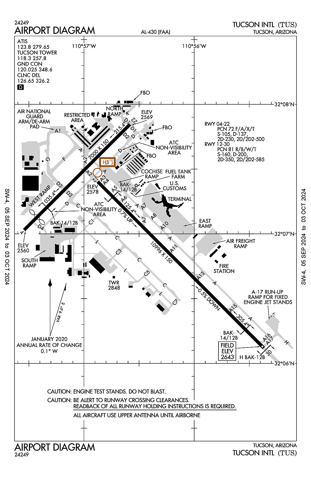
Tucson International
ICAO Identifier KTUS
Tucson, AZ
Tucson Intl
ICAO Identifier KTUS
AD 2.2 Aerodrome Geographical and Administrative Data
2.2.1 Reference Point: 32-07-01.4455N / 110-56-29.2661W
2.2.2 From City: 6 miles S of TUCSON, AZ
2.2.3 Elevation: 2643 ft
2.2.5 Magnetic Variation: 9E (2025)
2.2.6 Airport Contact: DANETTE BEWLEY
TUCSON APT AUTH 7250 S TUCSON BLVD
TUCSON, AZ 85756 (520-573-8190)
2.2.7 Traffic: IFR/VFR
AD 2.3 Attendance Schedule
2.3.1 All Months, All Days, All Hours
AD 2.4 Handling Services and Facilities
2.4.1 Cargo Handling Facilities: YES
2.4.2 Fuel Types: 100LL A A++
2.4.5 Hangar Space:
2.4.6 Repair Facilities: MAJOR
AD 2.6 Rescue and Firefighting Services
2.6.1 Aerodrome Category: Class-I certified on 5/1/1973
2.6.2 Rescue and Firefighting Services: ARFF Index-C
AD 2.12 Runway Physical Characteristics
2.12.1 Designation: 04
2.12.2 True Bearing: 45
2.12.3 True Dimensions: 7000 ft x 150 ft
2.12.4 PCN: 72 F/A/X/T
2.12.5 Coordinates: 32-07-01.7975N / 110-57-32.5438W
2.12.6 Threshold Elevation: 2560.2
2.12.6 Touchdown Zone Elevation: 2572.1
2.12.1 Designation: 22
2.12.2 True Bearing: 225
2.12.3 True Dimensions: 7000 ft x 150 ft
2.12.4 PCN: 72 F/A/X/T
2.12.5 Coordinates: 32-07-50.7361N / 110-56-34.9535W
2.12.6 Threshold Elevation: 2568.8
2.12.6 Touchdown Zone Elevation: 2572.4
2.12.1 Designation: 12
2.12.2 True Bearing: 135
2.12.3 True Dimensions: 10996 ft x 150 ft
2.12.4 PCN: 81 R/B/W/T
2.12.5 Coordinates: 32-07-24.1289N / 110-56-52.4852W
2.12.6 Threshold Elevation: 2577.7
2.12.6 Touchdown Zone Elevation: 2598.5
2.12.1 Designation: 30
2.12.2 True Bearing: 315
2.12.3 True Dimensions: 10996 ft x 150 ft
2.12.4 PCN: 81 R/B/W/T
2.12.5 Coordinates: 32-06-07.1598N / 110-55-22.1441W
2.12.6 Threshold Elevation: 2643
2.12.6 Touchdown Zone Elevation: 2643
AD 2.13 Declared Distances
2.13.1 Designation: 04
2.13.2 Take-off Run Available: 7000
2.13.3 Take-off Distance Available: 7000
2.13.4 Accelerate-Stop Distance Available: 7000
2.13.5 Landing Distance Available: 6150
2.13.1 Designation: 22
2.13.2 Take-off Run Available: 6000
2.13.3 Take-off Distance Available: 7000
2.13.4 Accelerate-Stop Distance Available: 6000
2.13.5 Landing Distance Available: 6000
2.13.1 Designation: 12
2.13.2 Take-off Run Available: 10996
2.13.3 Take-off Distance Available: 10996
2.13.4 Accelerate-Stop Distance Available: 10996
2.13.5 Landing Distance Available: 10996
2.13.1 Designation: 30
2.13.2 Take-off Run Available: 10996
2.13.3 Take-off Distance Available: 10996
2.13.4 Accelerate-Stop Distance Available: 10996
2.13.5 Landing Distance Available: 10996
AD 2.14 Approach and Runway Lighting
2.14.1 Designation: 04
2.14.2 Approach Lighting System:
2.14.4 Visual Approach Slope Indicator System:
2.14.1 Designation: 22
2.14.2 Approach Lighting System:
2.14.4 Visual Approach Slope Indicator System: P4L
2.14.1 Designation: 12
2.14.2 Approach Lighting System: MALSR
2.14.4 Visual Approach Slope Indicator System: P4L
2.14.1 Designation: 30
2.14.2 Approach Lighting System:
2.14.4 Visual Approach Slope Indicator System: P4L
AD 2.18 Air Traffic Services Communication Facilities
2.18.1 Service Designation: ANG COMD POST
2.18.3 Channel: 138.525
2.18.5 Hours of Operation:
2.18.1 Service Designation: ATIS
2.18.3 Channel: 123.8
2.18.5 Hours of Operation: 24
2.18.1 Service Designation: ATIS
2.18.3 Channel: 279.65
2.18.5 Hours of Operation: 24
2.18.1 Service Designation: CD/P
2.18.3 Channel: 126.65
2.18.5 Hours of Operation: 24
2.18.1 Service Designation: CD/P
2.18.3 Channel: 326.2
2.18.5 Hours of Operation: 24
2.18.1 Service Designation: EMERG
2.18.3 Channel: 121.5
2.18.5 Hours of Operation:
2.18.1 Service Designation: EMERG
2.18.3 Channel: 243
2.18.5 Hours of Operation:
2.18.1 Service Designation: GND/P
2.18.3 Channel: 120.025
2.18.5 Hours of Operation: 24
2.18.1 Service Designation: GND/P
2.18.3 Channel: 348.6
2.18.5 Hours of Operation: 24
2.18.1 Service Designation: LCL/P
2.18.3 Channel: 118.3
2.18.5 Hours of Operation: 24
2.18.1 Service Designation: LCL/P
2.18.3 Channel: 257.8
2.18.5 Hours of Operation: 24
2.18.1 Service Designation: LCL/S
2.18.3 Channel: 119
2.18.5 Hours of Operation: 24
AD 2.19 Radio Navigation and Landing Aids
2.19.1 ILS Type: DME for runway 12. Magnetic variation: 9E
2.19.2 ILS Identification: TUS
2.19.5 Coordinates: 32-05-54.9712N / 110-55-03.2284W
2.19.6 Site Elevation: 2676.1 ft
2.19.1 ILS Type: Glide Slop for runway 12. Magnetic variation: 9E
2.19.2 ILS Identification: TUS
2.19.5 Coordinates: 32-07-14.7604N / 110-56-48.0571W
2.19.6 Site Elevation: 2580.1 ft
2.19.1 ILS Type: Localizer for runway 12. Magnetic variation: 9E
2.19.2 ILS Identification: TUS
2.19.5 Coordinates: 32-05-53.16N / 110-55-05.69W
2.19.6 Site Elevation: 2660.2 ft
2.19.1 Navigation Aid Type VORTAC. Magnetic variation: 12E
2.19.2 Navigation Aid Identification: TUS
2.19.5 Coordinates: 32-05-42.7296N / 110-54-53.4781W
2.19.6 Site Elevation: 2670.5 ft
General Remarks:
GEN INFO - 520-573-8182.
CTN: REVIEW ARPT DIAGRAM HOT SPOT INFO.
MIL: ANG OFFL BUS ONLY; 72 HR PPR - D844-6731/C520-295-6731; FAX EXTN 6732. BASE OPS 1300Z-2300Z MON-FRI & DRILL WKEND 1300Z-2130Z; CLSD OTR WKENDS, HOL & SKED OFF DAYS. TRAN ALERT MAINT NA. TSNT SI FSL ONLY. CONTR FUEL NA.
TWY A5 LTD 70000 LB OR LESS.
CHARTER, SPORT TEAM, CARGO & MIL PPR - FBO. LNDG & PRKG FEE 12500 LBS & UP.
FLT TRNG 2200-0600 NA EXC PPR - 520-573-8190.
ACR USE RWY 04/22 & 12/30.
CTN: NW ARR & DEP DO NOT MISTAKE TWY A FOR LNDG SFC; TWY A N & PARL TO RWY 30.
MIL/COMM/BASE OPS ARR CTC TITAN OR PUMA - ANG BASE OPS/COMD POST FREQ.
PTNS TWY D NOT VIS FM ATCT.
USE UPPER ANT UNTIL AIRBORNE.
TXL K CLSD TO WINGSPAN GTR THAN 104 FT.
GROUP V TAX WITH INBOARD ENG ONLY. TRML RAMP CLSD TO ADG IV & ABV WO PPR.
A-GEAR BAK-14/BAK-12B APCH END RWY 12 & BAK-14/BAK-12B APCH END RWY 30 AVBL DURG ANG DUTY HR; 5 MIN PN.
OPR PARROT ALL SFCS, PUSHBACK & GATE ARR.
MIL: BIRD ACT PHASE II IN EFCT 1 JUL-31 AUG.
USCBP INSP RAMP RFLG NA EXC MED EMERG.
N RAMP CLSD TO WINGSPAN GTR THAN 79 FT.