Louisiana
New Orleans, Louisiana
Louis Armstrong New Orleans International
ICAO Identifier KMSY
New Orleans, LA
Louis Armstrong New Orleans Intl
ICAO Identifier KMSY
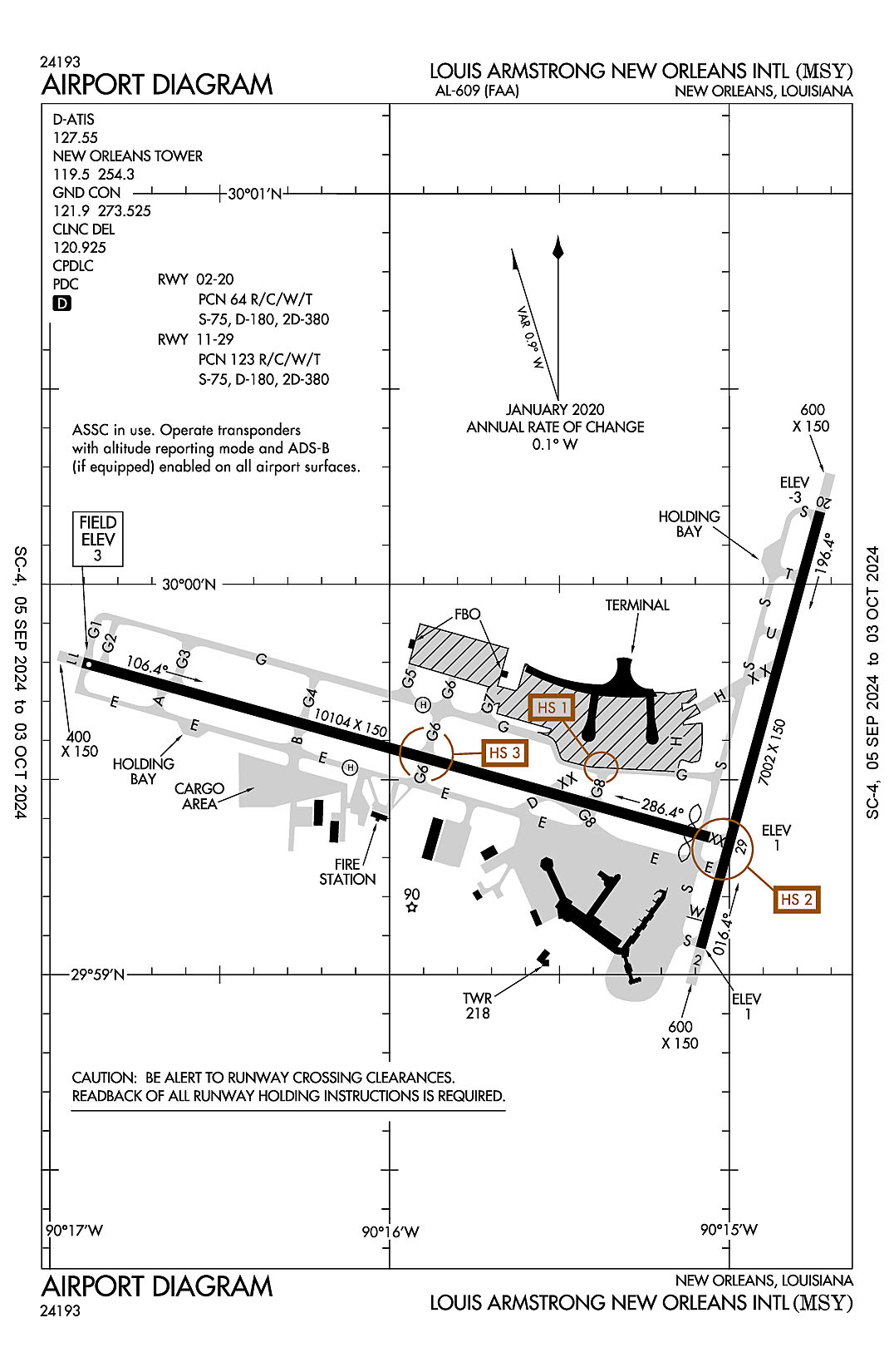
AD 2.2 Aerodrome Geographical and Administrative Data
2.2.1 Reference Point: 29-59-35.78N / 90-15-32.499W
2.2.2 From City: 10 miles W of NEW ORLEANS, LA
2.2.3 Elevation: 3 ft
2.2.5 Magnetic Variation: 1W (2020)
2.2.6 Airport Contact: KEVIN DOLLIOLE
PO BOX 20007
NEW ORLEANS, LA 70141 ((504) 303-7652)
2.2.7 Traffic: IFR/VFR
AD 2.3 Attendance Schedule
2.3.1 All Months, All Days, All Hours
AD 2.4 Handling Services and Facilities
2.4.1 Cargo Handling Facilities: YES
2.4.2 Fuel Types: 100LL A
2.4.5 Hangar Space:
2.4.6 Repair Facilities: NONE
AD 2.6 Rescue and Firefighting Services
2.6.1 Aerodrome Category: Class-I certified on 5/1/1973
2.6.2 Rescue and Firefighting Services: ARFF Index-D
AD 2.12 Runway Physical Characteristics
2.12.1 Designation: 02
2.12.2 True Bearing: 15
2.12.3 True Dimensions: 7002 ft x 150 ft
2.12.4 PCN: 64 R/C/W/T
2.12.5 Coordinates: 29-59-04.2046N / 90-15-05.0949W
2.12.6 Threshold Elevation: 1.3
2.12.6 Touchdown Zone Elevation: 1.6
2.12.1 Designation: 20
2.12.2 True Bearing: 195
2.12.3 True Dimensions: 7002 ft x 150 ft
2.12.4 PCN: 64 R/C/W/T
2.12.5 Coordinates: 30-00-10.9937N / 90-14-43.837W
2.12.6 Threshold Elevation: -2.9
2.12.6 Touchdown Zone Elevation: -1.1
2.12.1 Designation: 11
2.12.2 True Bearing: 105
2.12.3 True Dimensions: 10104 ft x 150 ft
2.12.4 PCN: 123 R/C/W/T
2.12.5 Coordinates: 29-59-47.857N / 90-16-54.2234W
2.12.6 Threshold Elevation: 3
2.12.6 Touchdown Zone Elevation: 3
2.12.1 Designation: 29
2.12.2 True Bearing: 285
2.12.3 True Dimensions: 10104 ft x 150 ft
2.12.4 PCN: 123 R/C/W/T
2.12.5 Coordinates: 29-59-21.1717N / 90-15-03.4851W
2.12.6 Threshold Elevation: 0.5
2.12.6 Touchdown Zone Elevation: 1.5
2.12.1 Designation: H1
2.12.2 True Bearing:
2.12.3 True Dimensions: 50 ft x 50 ft
2.12.4 PCN:
2.12.5 Coordinates: 29-59-31.9N / 90-16-06.84W
2.12.6 Threshold Elevation: 0
2.12.6 Touchdown Zone Elevation:
2.12.1 Designation: H2
2.12.2 True Bearing:
2.12.3 True Dimensions: 50 ft x 50 ft
2.12.4 PCN:
2.12.5 Coordinates: 29-59-41.5N / 90-15-54.01W
2.12.6 Threshold Elevation: 0
2.12.6 Touchdown Zone Elevation:
AD 2.13 Declared Distances
2.13.1 Designation: 02
2.13.2 Take-off Run Available: 7002
2.13.3 Take-off Distance Available: 7002
2.13.4 Accelerate-Stop Distance Available: 7002
2.13.5 Landing Distance Available: 7002
2.13.1 Designation: 20
2.13.2 Take-off Run Available: 7002
2.13.3 Take-off Distance Available: 7002
2.13.4 Accelerate-Stop Distance Available: 6948
2.13.5 Landing Distance Available: 6948
2.13.1 Designation: 11
2.13.2 Take-off Run Available: 10104
2.13.3 Take-off Distance Available: 10104
2.13.4 Accelerate-Stop Distance Available: 9800
2.13.5 Landing Distance Available: 9800
2.13.1 Designation: 29
2.13.2 Take-off Run Available: 10104
2.13.3 Take-off Distance Available: 10104
2.13.4 Accelerate-Stop Distance Available: 10104
2.13.5 Landing Distance Available: 9800
2.13.1 Designation: H1
2.13.2 Take-off Run Available:
2.13.3 Take-off Distance Available:
2.13.4 Accelerate-Stop Distance Available:
2.13.5 Landing Distance Available:
2.13.1 Designation: H2
2.13.2 Take-off Run Available:
2.13.3 Take-off Distance Available:
2.13.4 Accelerate-Stop Distance Available:
2.13.5 Landing Distance Available:
AD 2.14 Approach and Runway Lighting
2.14.1 Designation: 02
2.14.2 Approach Lighting System: RLLS
2.14.4 Visual Approach Slope Indicator System: P4L
2.14.1 Designation: 20
2.14.2 Approach Lighting System: MALS
2.14.4 Visual Approach Slope Indicator System: P4L
2.14.1 Designation: 11
2.14.2 Approach Lighting System: ALSF2
2.14.4 Visual Approach Slope Indicator System: P4R
2.14.1 Designation: 29
2.14.2 Approach Lighting System: MALSR
2.14.4 Visual Approach Slope Indicator System: P4R
2.14.1 Designation: H1
2.14.2 Approach Lighting System:
2.14.4 Visual Approach Slope Indicator System:
2.14.1 Designation: H2
2.14.2 Approach Lighting System:
2.14.4 Visual Approach Slope Indicator System:
AD 2.18 Air Traffic Services Communication Facilities
2.18.1 Service Designation: APCH/P DEP/P (WEST)
2.18.3 Channel: 125.5
2.18.5 Hours of Operation: 24
2.18.1 Service Designation: APCH/P DEP/P (EAST)
2.18.3 Channel: 133.15
2.18.5 Hours of Operation: 24
2.18.1 Service Designation: APCH/P DEP/P (EAST)
2.18.3 Channel: 290.3
2.18.5 Hours of Operation: 24
2.18.1 Service Designation: APCH/P DEP/P (WEST)
2.18.3 Channel: 350.35
2.18.5 Hours of Operation: 24
2.18.1 Service Designation: APCH/S
2.18.3 Channel: 269.2
2.18.5 Hours of Operation: 24
2.18.1 Service Designation: AWDAD STAR (WEST)
2.18.3 Channel: 125.5
2.18.5 Hours of Operation: 24
2.18.1 Service Designation: AWDAD STAR (WEST)
2.18.3 Channel: 350.35
2.18.5 Hours of Operation: 24
2.18.1 Service Designation: CD PRE TAXI CLNC
2.18.3 Channel: 120.925
2.18.5 Hours of Operation: 24
2.18.1 Service Designation: CD/P
2.18.3 Channel: 120.925
2.18.5 Hours of Operation: 24
2.18.1 Service Designation: CLASS B (SE & SOUTH)
2.18.3 Channel: 123.85
2.18.5 Hours of Operation: 24
2.18.1 Service Designation: CLASS B (WEST)
2.18.3 Channel: 125.5
2.18.5 Hours of Operation: 24
2.18.1 Service Designation: CLASS B (NORTH & EAST)
2.18.3 Channel: 133.15
2.18.5 Hours of Operation: 24
2.18.1 Service Designation: CLASS B (SE & SOUTH)
2.18.3 Channel: 256.9
2.18.5 Hours of Operation: 24
2.18.1 Service Designation: CLASS B (NORTH & EAST)
2.18.3 Channel: 290.3
2.18.5 Hours of Operation: 24
2.18.1 Service Designation: CLASS B (WEST)
2.18.3 Channel: 350.35
2.18.5 Hours of Operation: 24
2.18.1 Service Designation: D-ATIS
2.18.3 Channel: 127.55
2.18.5 Hours of Operation: 24
2.18.1 Service Designation: EMERG
2.18.3 Channel: 121.5
2.18.5 Hours of Operation:
2.18.1 Service Designation: EMERG
2.18.3 Channel: 243
2.18.5 Hours of Operation:
2.18.1 Service Designation: GND/P
2.18.3 Channel: 121.9
2.18.5 Hours of Operation: 24
2.18.1 Service Designation: GND/P
2.18.3 Channel: 273.525
2.18.5 Hours of Operation: 24
2.18.1 Service Designation: LCL/P
2.18.3 Channel: 119.5
2.18.5 Hours of Operation: 24
2.18.1 Service Designation: LCL/P
2.18.3 Channel: 254.3
2.18.5 Hours of Operation: 24
2.18.1 Service Designation: MNSTR STAR (EAST)
2.18.3 Channel: 133.15
2.18.5 Hours of Operation: 24
2.18.1 Service Designation: MNSTR STAR (EAST)
2.18.3 Channel: 290.3
2.18.5 Hours of Operation: 24
2.18.1 Service Designation: OLEDD STAR (WEST)
2.18.3 Channel: 125.5
2.18.5 Hours of Operation: 24
2.18.1 Service Designation: OLEDD STAR (WEST)
2.18.3 Channel: 350.35
2.18.5 Hours of Operation: 24
AD 2.19 Radio Navigation and Landing Aids
2.19.1 ILS Type: DME for runway 02. Magnetic variation: 1W
2.19.2 ILS Identification: JFI
2.19.5 Coordinates: 30-00-21.6556N / 90-14-43.2405W
2.19.6 Site Elevation: 9.1 ft
2.19.1 ILS Type: Glide Slop for runway 02. Magnetic variation: 1W
2.19.2 ILS Identification: JFI
2.19.5 Coordinates: 29-59-13.6243N / 90-14-58.6631W
2.19.6 Site Elevation: -2 ft
2.19.1 ILS Type: Localizer for runway 02. Magnetic variation: 1W
2.19.2 ILS Identification: JFI
2.19.5 Coordinates: 30-00-20.6664N / 90-14-40.8693W
2.19.6 Site Elevation: -6 ft
2.19.1 ILS Type: DME for runway 20. Magnetic variation: 1W
2.19.2 ILS Identification: ONW
2.19.5 Coordinates: 30-00-21.6556N / 90-14-43.2405W
2.19.6 Site Elevation: 9.1 ft
2.19.1 ILS Type: Localizer for runway 20. Magnetic variation: 1W
2.19.2 ILS Identification: ONW
2.19.5 Coordinates: 29-58-55.1159N / 90-15-07.984W
2.19.6 Site Elevation: 0.8 ft
2.19.1 ILS Type: DME for runway 11. Magnetic variation: 1W
2.19.2 ILS Identification: MSY
2.19.5 Coordinates: 29-59-17.2296N / 90-14-55.6762W
2.19.6 Site Elevation: 12.4 ft
2.19.1 ILS Type: Glide Slop for runway 11. Magnetic variation: 1W
2.19.2 ILS Identification: MSY
2.19.5 Coordinates: 29-59-48.6156N / 90-16-39.2463W
2.19.6 Site Elevation: -3.8 ft
2.19.1 ILS Type: Inner Marker for runway 11. Magnetic variation: 1W
2.19.2 ILS Identification: MSY
2.19.5 Coordinates: 29-59-50.2618N / 90-17-04.1774W
2.19.6 Site Elevation: 3.1 ft
2.19.1 ILS Type: Localizer for runway 11. Magnetic variation: 1W
2.19.2 ILS Identification: MSY
2.19.5 Coordinates: 29-59-19.3208N / 90-14-55.8537W
2.19.6 Site Elevation: -1.1 ft
2.19.1 ILS Type: DME for runway 29. Magnetic variation: 1W
2.19.2 ILS Identification: HOX
2.19.5 Coordinates: 29-59-17.2296N / 90-14-55.6762W
2.19.6 Site Elevation: 12.4 ft
2.19.1 ILS Type: Glide Slop for runway 29. Magnetic variation: 1W
2.19.2 ILS Identification: HOX
2.19.5 Coordinates: 29-59-27.9678N / 90-15-16.788W
2.19.6 Site Elevation: -0.3 ft
2.19.1 ILS Type: Localizer for runway 29. Magnetic variation: 1W
2.19.2 ILS Identification: HOX
2.19.5 Coordinates: 29-59-50.5146N / 90-17-05.2664W
2.19.6 Site Elevation: 3.4 ft
General Remarks:
180 DEG & LOCKED WHEEL TURNS PROHIBITED ON ASPH SFC ACFT 12500 LBS & OVER.
FLOCKS OF BIRDS ON & IN VICINITY OF ARPT.
TWY G BTN RWY 11/29 AND TWY S SFC MOV GUIDANCE AND CTL SYSTEM U/S PERM
RY 11 NOISE SENSITIVE FOR DEP; AVBL FOR OPNL NECESSITY. ALL RYS NOISE SENSITIVE FOR ARR. ARRIVING TURBOJETS MUST MAKE 5 MILE FINAL APCH TO MINIMIZE NOISE.