New Jersey
Newark, New Jersey
Newark Liberty International
ICAO Identifier KEWR
Newark, NJ
Newark Liberty Intl
ICAO Identifier KEWR
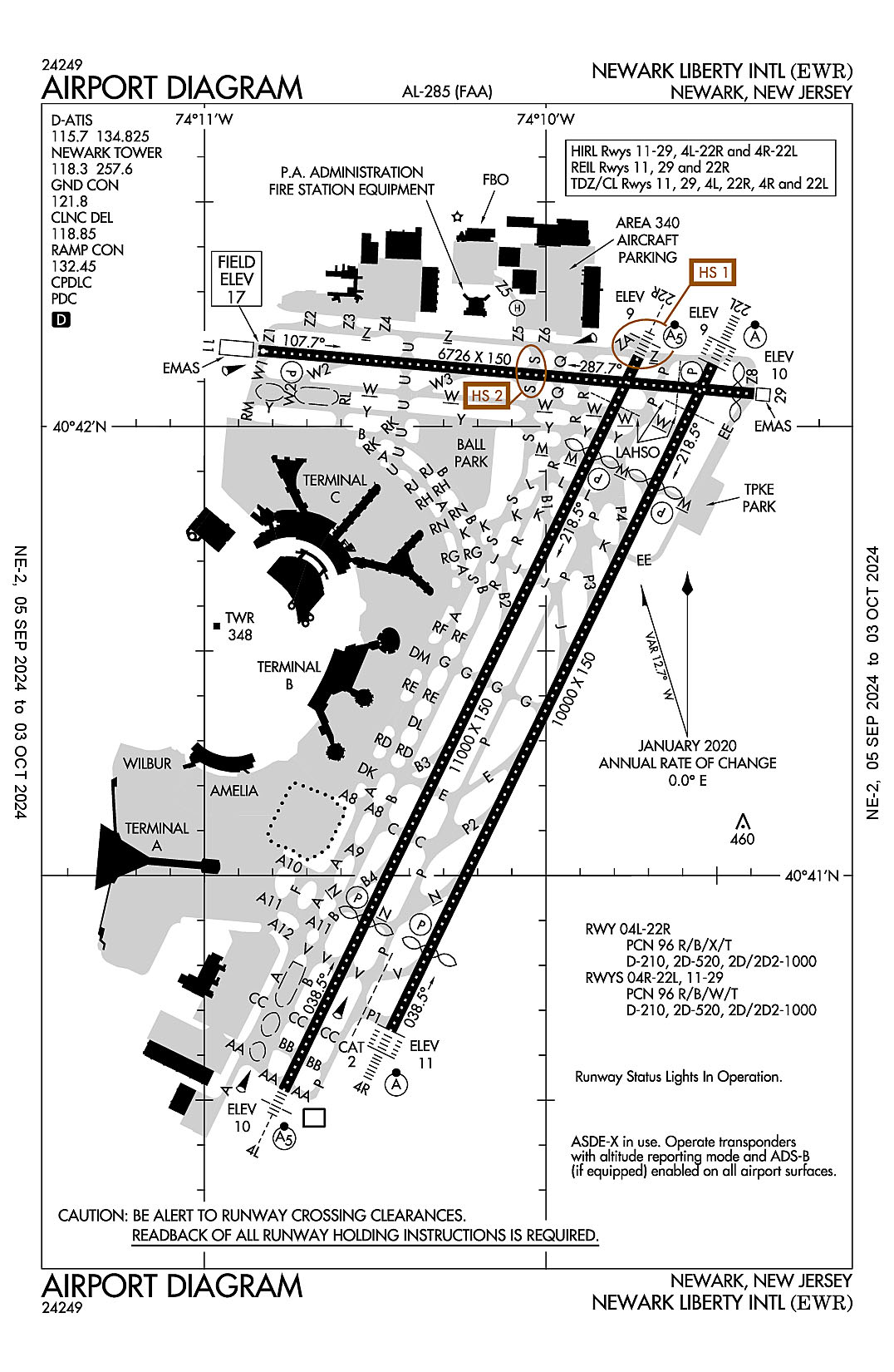
AD 2.2 Aerodrome Geographical and Administrative Data
2.2.1 Reference Point: 40-41-32.9274N / 74-10-07.2724W
2.2.2 From City: 3 miles S of NEWARK, NJ
2.2.3 Elevation: 17.4 ft
2.2.5 Magnetic Variation: 13W (1985)
2.2.6 Airport Contact: SARAH K. MCKEON
BUILDING #1- CONRAD ROAD
NEWARK, NJ 7114 (973-961-6161)
2.2.7 Traffic: IFR/VFR
AD 2.3 Attendance Schedule
2.3.1 All Months, All Days, All Hours
AD 2.4 Handling Services and Facilities
2.4.1 Cargo Handling Facilities: YES
2.4.2 Fuel Types: 100LL A
2.4.5 Hangar Space: YES
2.4.6 Repair Facilities: MAJOR
AD 2.6 Rescue and Firefighting Services
2.6.1 Aerodrome Category: Class-I certified on 5/1/1973
2.6.2 Rescue and Firefighting Services: ARFF Index-E
AD 2.12 Runway Physical Characteristics
2.12.1 Designation: 04L
2.12.2 True Bearing: 26
2.12.3 True Dimensions: 11000 ft x 150 ft
2.12.4 PCN: 96 R/B/X/T
2.12.5 Coordinates: 40-40-31.3716N / 74-10-46.0209W
2.12.6 Threshold Elevation: 10.1
2.12.6 Touchdown Zone Elevation: 10.4
2.12.1 Designation: 22R
2.12.2 True Bearing: 206
2.12.3 True Dimensions: 11000 ft x 150 ft
2.12.4 PCN: 96 R/B/X/T
2.12.5 Coordinates: 40-42-09.2091N / 74-09-43.8255W
2.12.6 Threshold Elevation: 8.9
2.12.6 Touchdown Zone Elevation: 10.4
2.12.1 Designation: 22L
2.12.2 True Bearing: 206
2.12.3 True Dimensions: 10000 ft x 150 ft
2.12.4 PCN: 96 R/B/W/T
2.12.5 Coordinates: 40-42-08.2438N / 74-09-30.7308W
2.12.6 Threshold Elevation: 9.4
2.12.6 Touchdown Zone Elevation: 10.7
2.12.1 Designation: 04R
2.12.2 True Bearing: 26
2.12.3 True Dimensions: 10000 ft x 150 ft
2.12.4 PCN: 96 R/B/W/T
2.12.5 Coordinates: 40-40-39.2984N / 74-10-27.2835W
2.12.6 Threshold Elevation: 11.1
2.12.6 Touchdown Zone Elevation: 11.3
2.12.1 Designation: 29
2.12.2 True Bearing: 275
2.12.3 True Dimensions: 6726 ft x 150 ft
2.12.4 PCN: 96 R/B/W/T
2.12.5 Coordinates: 40-42-04.3181N / 74-09-23.5515W
2.12.6 Threshold Elevation: 9.7
2.12.6 Touchdown Zone Elevation: 9.8
2.12.1 Designation: 11
2.12.2 True Bearing: 95
2.12.3 True Dimensions: 6726 ft x 150 ft
2.12.4 PCN: 96 R/B/W/T
2.12.5 Coordinates: 40-42-10.0955N / 74-10-50.5467W
2.12.6 Threshold Elevation: 17.4
2.12.6 Touchdown Zone Elevation: 17.4
2.12.1 Designation: H1
2.12.2 True Bearing:
2.12.3 True Dimensions: 54 ft x 54 ft
2.12.4 PCN:
2.12.5 Coordinates: 40-42-15.85N / 74-10-05W
2.12.6 Threshold Elevation: 8
2.12.6 Touchdown Zone Elevation:
AD 2.13 Declared Distances
2.13.1 Designation: 04L
2.13.2 Take-off Run Available: 11000
2.13.3 Take-off Distance Available: 11000
2.13.4 Accelerate-Stop Distance Available: 11000
2.13.5 Landing Distance Available: 8460
2.13.1 Designation: 22R
2.13.2 Take-off Run Available: 11000
2.13.3 Take-off Distance Available: 11000
2.13.4 Accelerate-Stop Distance Available: 11000
2.13.5 Landing Distance Available: 9560
2.13.1 Designation: 22L
2.13.2 Take-off Run Available: 10000
2.13.3 Take-off Distance Available: 10000
2.13.4 Accelerate-Stop Distance Available: 10000
2.13.5 Landing Distance Available: 8207
2.13.1 Designation: 04R
2.13.2 Take-off Run Available: 10000
2.13.3 Take-off Distance Available: 10000
2.13.4 Accelerate-Stop Distance Available: 10000
2.13.5 Landing Distance Available: 8810
2.13.1 Designation: 29
2.13.2 Take-off Run Available: 6726
2.13.3 Take-off Distance Available: 6726
2.13.4 Accelerate-Stop Distance Available: 6726
2.13.5 Landing Distance Available: 6502
2.13.1 Designation: 11
2.13.2 Take-off Run Available: 6726
2.13.3 Take-off Distance Available: 6726
2.13.4 Accelerate-Stop Distance Available: 6726
2.13.5 Landing Distance Available: 6726
2.13.1 Designation: H1
2.13.2 Take-off Run Available:
2.13.3 Take-off Distance Available:
2.13.4 Accelerate-Stop Distance Available:
2.13.5 Landing Distance Available:
AD 2.14 Approach and Runway Lighting
2.14.1 Designation: 04L
2.14.2 Approach Lighting System: MALSR
2.14.4 Visual Approach Slope Indicator System: P4L
2.14.1 Designation: 22R
2.14.2 Approach Lighting System: MALSR
2.14.4 Visual Approach Slope Indicator System: P4L
2.14.1 Designation: 22L
2.14.2 Approach Lighting System: ALSF2
2.14.4 Visual Approach Slope Indicator System: P4L
2.14.1 Designation: 04R
2.14.2 Approach Lighting System: ALSF2
2.14.4 Visual Approach Slope Indicator System: P4L
2.14.1 Designation: 29
2.14.2 Approach Lighting System:
2.14.4 Visual Approach Slope Indicator System: P4R
2.14.1 Designation: 11
2.14.2 Approach Lighting System:
2.14.4 Visual Approach Slope Indicator System: P4R
2.14.1 Designation: H1
2.14.2 Approach Lighting System:
2.14.4 Visual Approach Slope Indicator System:
AD 2.18 Air Traffic Services Communication Facilities
2.18.1 Service Designation: CD PRE TAXI CLNC
2.18.3 Channel: 118.85
2.18.5 Hours of Operation: 24
2.18.1 Service Designation: CLASS B (WITHIN 6.5 NM ARE TWR CONTROLLED FREQS)
2.18.3 Channel: 127.85
2.18.5 Hours of Operation:
2.18.1 Service Designation: CLASS B (WITHIN 6.5 NM ARE TWR CONTROLLED FREQS)
2.18.3 Channel: 257.6
2.18.5 Hours of Operation:
2.18.1 Service Designation: D-ATIS (ARR)
2.18.3 Channel: 115.7
2.18.5 Hours of Operation: 24
2.18.1 Service Designation: D-ATIS
2.18.3 Channel: 134.825
2.18.5 Hours of Operation: 24
2.18.1 Service Designation: EMERG
2.18.3 Channel: 121.5
2.18.5 Hours of Operation:
2.18.1 Service Designation: EMERG
2.18.3 Channel: 243
2.18.5 Hours of Operation:
2.18.1 Service Designation: GND/P
2.18.3 Channel: 121.8
2.18.5 Hours of Operation: 24
2.18.1 Service Designation: GND/S
2.18.3 Channel: 126.15
2.18.5 Hours of Operation: 24
2.18.1 Service Designation: LCL/P
2.18.3 Channel: 118.3
2.18.5 Hours of Operation: 24
2.18.1 Service Designation: LCL/P (WITHIN 6.5 NM ARE TWR CONTROLLED FREQS)
2.18.3 Channel: 257.6
2.18.5 Hours of Operation: 24
2.18.1 Service Designation: LCL/S
2.18.3 Channel: 134.05
2.18.5 Hours of Operation: 24
2.18.1 Service Designation: RAMP CTL
2.18.3 Channel: 132.45
2.18.5 Hours of Operation:
AD 2.19 Radio Navigation and Landing Aids
2.19.1 ILS Type: DME for runway 04L. Magnetic variation: 13W
2.19.2 ILS Identification: EWR
2.19.5 Coordinates: 40-42-15.686N / 74-09-33.736W
2.19.6 Site Elevation: 34.3 ft
2.19.1 ILS Type: Glide Slop for runway 04L. Magnetic variation: 13W
2.19.2 ILS Identification: EWR
2.19.5 Coordinates: 40-41-02.167N / 74-10-22.759W
2.19.6 Site Elevation: 7.4 ft
2.19.1 ILS Type: Localizer for runway 04L. Magnetic variation: 13W
2.19.2 ILS Identification: EWR
2.19.5 Coordinates: 40-42-18.192N / 74-09-38.112W
2.19.6 Site Elevation: 8.7 ft
2.19.1 ILS Type: DME for runway 22R. Magnetic variation: 13W
2.19.2 ILS Identification: JNN
2.19.5 Coordinates: 40-42-15.686N / 74-09-33.736W
2.19.6 Site Elevation: 34.3 ft
2.19.1 ILS Type: Glide Slop for runway 22R. Magnetic variation: 13W
2.19.2 ILS Identification: JNN
2.19.5 Coordinates: 40-41-47.5592N / 74-09-53.883W
2.19.6 Site Elevation: 8 ft
2.19.1 ILS Type: Localizer for runway 22R. Magnetic variation: 13W
2.19.2 ILS Identification: JNN
2.19.5 Coordinates: 40-40-22.392N / 74-10-51.726W
2.19.6 Site Elevation: 9.1 ft
2.19.1 ILS Type: DME for runway 04R. Magnetic variation: 13W
2.19.2 ILS Identification: EZA
2.19.5 Coordinates: 40-41-43.5471N / 74-09-41.6275W
2.19.6 Site Elevation: 33.5 ft
2.19.1 ILS Type: Glide Slop for runway 04R. Magnetic variation: 13W
2.19.2 ILS Identification: EZA
2.19.5 Coordinates: 40-40-57.598N / 74-10-09.8776W
2.19.6 Site Elevation: 6 ft
2.19.1 ILS Type: Localizer for runway 04R. Magnetic variation: 13W
2.19.2 ILS Identification: EZA
2.19.5 Coordinates: 40-42-15.9432N / 74-09-25.8352W
2.19.6 Site Elevation: 8.1 ft
2.19.1 ILS Type: DME for runway 22L. Magnetic variation: 13W
2.19.2 ILS Identification: LSQ
2.19.5 Coordinates: 40-41-43.5471N / 74-09-41.6275W
2.19.6 Site Elevation: 33.5 ft
2.19.1 ILS Type: Glide Slop for runway 22L. Magnetic variation: 13W
2.19.2 ILS Identification: LSQ
2.19.5 Coordinates: 40-41-43.6732N / 74-09-41.7368W
2.19.6 Site Elevation: 7.4 ft
2.19.1 ILS Type: Localizer for runway 22L. Magnetic variation: 13W
2.19.2 ILS Identification: LSQ
2.19.5 Coordinates: 40-40-28.9529N / 74-10-33.8654W
2.19.6 Site Elevation: 9.4 ft
2.19.1 ILS Type: DME for runway 11. Magnetic variation: 13W
2.19.2 ILS Identification: GPR
2.19.5 Coordinates: 40-42-09.5406N / 74-10-04.0694W
2.19.6 Site Elevation: 7.1 ft
2.19.1 ILS Type: Glide Slop for runway 11. Magnetic variation: 13W
2.19.2 ILS Identification: GPR
2.19.5 Coordinates: 40-42-10.837N / 74-10-35.03W
2.19.6 Site Elevation: 9.5 ft
2.19.1 ILS Type: Localizer for runway 11. Magnetic variation: 13W
2.19.2 ILS Identification: GPR
2.19.5 Coordinates: 40-42-09.2938N / 74-10-04.9852W
2.19.6 Site Elevation: 7 ft
2.19.1 Navigation Aid Type DME. Magnetic variation:
2.19.2 Navigation Aid Identification: EWR
2.19.5 Coordinates: 40-40-27.64N / 74-10-40.68W
2.19.6 Site Elevation: 9 ft
2.19.1 Navigation Aid Type FAN MARKER. Magnetic variation: 11W
2.19.2 Navigation Aid Identification: EWR
2.19.5 Coordinates: 40-42-12.1824N / 74-11-14.7211W
2.19.6 Site Elevation: 9.5 ft
General Remarks:
DURNG ATC ZERO EVENTS; ARPT OPS WILL MNT 118.3 AND PROVIDE EMERG NOTIFICATIONS TO ARFF
HIGH VOLUME OF LOW LEVEL HEL TFC ARR AND DEP HELO KEARNY HELI (65NJ) LCTD 3.5 MILES NE OF ARPT.
WHEN RWY 22L/R IN USE, ACFT PRKG AT TRML A CAN EXP TO ENTER RAMP VIA TWY A10 OR A12, UNLESS ADZD BY ATC.
TWY Z5 CLSD TO ACFT WITH WINGSPANS IN EXCESS OF 118 FT.
TWY Z BTN TWY Z2 & Z4 CLSD TO ACFT WITH WINGSPANS IN EXCESS OF 171 FT.
TWY A11 W OF TWY A ACFT SPD RSTR OF 17 KTS/20 MPH MAX FOR ALL ACFT WITH WINGSPANS IN EXCESS OF 171 FT.
ADG IV ACFT RSTR FM PSG TWY Z3 ON Z
TWY EE BTN RWY 4R-22L AND RWY 11-29 CLSD TO AFCT WITH WINGSPANS IN EXCESS OF 171 FT.
NOISE RSTR CALL 212-435-3784 DRG NML BUS HRS.
FLOCKS OF BIRDS ON & INVOF ARPT.
TWY A BTN TWY AA AND RAMP CLSD TO ACFT WITH WINGSPANS IN EXCESS OF 171 FT.
RWY STATUS LIGHTS IN OPR
TWY Y BTN RM AND TWY U, SPEED RESTRICTION OF 17KT (20MPH).
PARA-SAIL & BANNER TOWING OPS 1000 FT & BLO IN UPPER & LOWER NY BAYS INCLUDING ROCKAWAY INLET INDEF.
WHEN RWY 04R/L IN USE, ACFT PRKG AT TRML A CAN EXP TO ENTER RAMP VIA TWY A8, UNLESS ADZD BY ATC.
CPDLC DEPARTURE CLEARANCE SERVICE AVAILABLE.
ACFT WITH WINGSPANS IN EXCESS OF 118 FEET PROHIBITED FROM TURNING S ON TWY R FROM TWY B1.
ALL TWYS SURROUNDING "BALLPARK" PRKG AREA (TWY Y BTN TWY S AND TWY U, TWY S BTN TWY Y AND TWY K, TWAY K BTN TWY S AND TWY B, TWY B BTN TWY K AND TWY U, AND TWY U BTN TWY B AND TWY Y) ACFT SPEED RSTR OF 17KTS/20MPH FOR ALL AFCT WITH WINGSPANS IN EXCESS OF 171 FT.
RWY 4R & 4L DEP USE UPPER ANT FOR ATC COM.
TWY Z EAST OF TWY U ACFT SPEED RSTR OF 17 KTS/20 MPH MAX FOR ALL ACFT WITH WINGSPANS IN EXCESS OF 171 FT.