Tennessee
Memphis, Tennessee
Memphis International
ICAO Identifier KMEM
Memphis, TN
Memphis Intl
ICAO Identifier KMEM
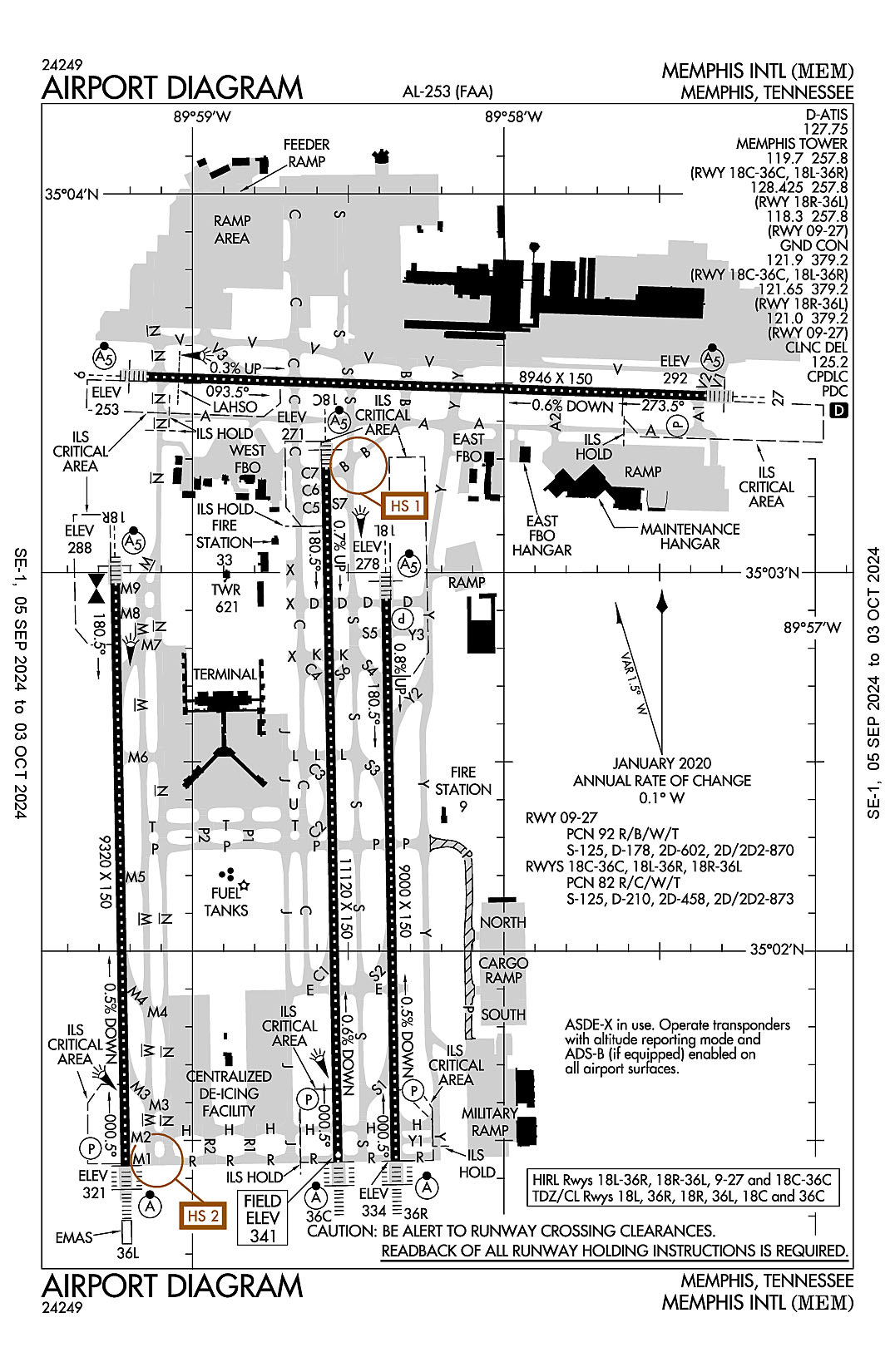
AD 2.2 Aerodrome Geographical and Administrative Data
2.2.1 Reference Point: 35-02-32.681N / 89-58-36.045W
2.2.2 From City: 3 miles S of MEMPHIS, TN
2.2.3 Elevation: 340.9 ft
2.2.5 Magnetic Variation: 1W (2020)
2.2.6 Airport Contact: TERRY BLUE
2491 WINCHESTER RD.
MEMPHIS, TN 38116 (901-922-8000)
2.2.7 Traffic: IFR/VFR
AD 2.3 Attendance Schedule
2.3.1 All Months, All Days, All Hours
AD 2.4 Handling Services and Facilities
2.4.1 Cargo Handling Facilities: YES
2.4.2 Fuel Types: 100LL A A+ A++
2.4.5 Hangar Space: YES
2.4.6 Repair Facilities: MAJOR
AD 2.6 Rescue and Firefighting Services
2.6.1 Aerodrome Category: Class-I certified on 5/21/1973
2.6.2 Rescue and Firefighting Services: ARFF Index-C
AD 2.12 Runway Physical Characteristics
2.12.1 Designation: 27
2.12.2 True Bearing: 272
2.12.3 True Dimensions: 8946 ft x 150 ft
2.12.4 PCN: 92 R/B/W/T
2.12.5 Coordinates: 35-03-28.0128N / 89-57-21.0816W
2.12.6 Threshold Elevation: 292
2.12.6 Touchdown Zone Elevation: 292
2.12.1 Designation: 09
2.12.2 True Bearing: 92
2.12.3 True Dimensions: 8946 ft x 150 ft
2.12.4 PCN: 92 R/B/W/T
2.12.5 Coordinates: 35-03-31.046N / 89-59-08.6536W
2.12.6 Threshold Elevation: 253.2
2.12.6 Touchdown Zone Elevation: 258.7
2.12.1 Designation: 18C
2.12.2 True Bearing: 179
2.12.3 True Dimensions: 11120 ft x 150 ft
2.12.4 PCN: 82 R/C/W/T
2.12.5 Coordinates: 35-03-16.5411N / 89-58-34.2156W
2.12.6 Threshold Elevation: 270.6
2.12.6 Touchdown Zone Elevation: 290.1
2.12.1 Designation: 36C
2.12.2 True Bearing: 359
2.12.3 True Dimensions: 11120 ft x 150 ft
2.12.4 PCN: 82 R/C/W/T
2.12.5 Coordinates: 35-01-26.5803N / 89-58-31.8977W
2.12.6 Threshold Elevation: 340.9
2.12.6 Touchdown Zone Elevation: 340.9
2.12.1 Designation: 18L
2.12.2 True Bearing: 179
2.12.3 True Dimensions: 9000 ft x 150 ft
2.12.4 PCN: 82 R/C/W/T
2.12.5 Coordinates: 35-02-55.7402N / 89-58-22.6229W
2.12.6 Threshold Elevation: 277.6
2.12.6 Touchdown Zone Elevation: 300.9
2.12.1 Designation: 36R
2.12.2 True Bearing: 359
2.12.3 True Dimensions: 9000 ft x 150 ft
2.12.4 PCN: 82 R/C/W/T
2.12.5 Coordinates: 35-01-26.7376N / 89-58-20.7544W
2.12.6 Threshold Elevation: 334.3
2.12.6 Touchdown Zone Elevation: 334.7
2.12.1 Designation: 36L
2.12.2 True Bearing: 359
2.12.3 True Dimensions: 9320 ft x 150 ft
2.12.4 PCN: 82 R/C/W/T
2.12.5 Coordinates: 35-01-25.9852N / 89-59-12.8121W
2.12.6 Threshold Elevation: 320.8
2.12.6 Touchdown Zone Elevation: 320.8
2.12.1 Designation: 18R
2.12.2 True Bearing: 179
2.12.3 True Dimensions: 9320 ft x 150 ft
2.12.4 PCN: 82 R/C/W/T
2.12.5 Coordinates: 35-02-58.1489N / 89-59-14.7913W
2.12.6 Threshold Elevation: 288.4
2.12.6 Touchdown Zone Elevation: 294.7
AD 2.13 Declared Distances
2.13.1 Designation: 27
2.13.2 Take-off Run Available: 8946
2.13.3 Take-off Distance Available: 8946
2.13.4 Accelerate-Stop Distance Available: 8946
2.13.5 Landing Distance Available: 8946
2.13.1 Designation: 09
2.13.2 Take-off Run Available: 8946
2.13.3 Take-off Distance Available: 8946
2.13.4 Accelerate-Stop Distance Available: 8946
2.13.5 Landing Distance Available: 8946
2.13.1 Designation: 18C
2.13.2 Take-off Run Available: 11120
2.13.3 Take-off Distance Available: 11120
2.13.4 Accelerate-Stop Distance Available: 11120
2.13.5 Landing Distance Available: 11120
2.13.1 Designation: 36C
2.13.2 Take-off Run Available: 11120
2.13.3 Take-off Distance Available: 11120
2.13.4 Accelerate-Stop Distance Available: 10715
2.13.5 Landing Distance Available: 10715
2.13.1 Designation: 18L
2.13.2 Take-off Run Available: 9000
2.13.3 Take-off Distance Available: 9000
2.13.4 Accelerate-Stop Distance Available: 9000
2.13.5 Landing Distance Available: 9000
2.13.1 Designation: 36R
2.13.2 Take-off Run Available: 9000
2.13.3 Take-off Distance Available: 9000
2.13.4 Accelerate-Stop Distance Available: 9000
2.13.5 Landing Distance Available: 9000
2.13.1 Designation: 36L
2.13.2 Take-off Run Available: 9320
2.13.3 Take-off Distance Available: 9320
2.13.4 Accelerate-Stop Distance Available: 9320
2.13.5 Landing Distance Available: 9320
2.13.1 Designation: 18R
2.13.2 Take-off Run Available: 9320
2.13.3 Take-off Distance Available: 9320
2.13.4 Accelerate-Stop Distance Available: 9320
2.13.5 Landing Distance Available: 9320
AD 2.14 Approach and Runway Lighting
2.14.1 Designation: 27
2.14.2 Approach Lighting System: MALSR
2.14.4 Visual Approach Slope Indicator System: P4L
2.14.1 Designation: 09
2.14.2 Approach Lighting System: MALSR
2.14.4 Visual Approach Slope Indicator System:
2.14.1 Designation: 18C
2.14.2 Approach Lighting System: MALSR
2.14.4 Visual Approach Slope Indicator System:
2.14.1 Designation: 36C
2.14.2 Approach Lighting System: ALSF2
2.14.4 Visual Approach Slope Indicator System: P4L
2.14.1 Designation: 18L
2.14.2 Approach Lighting System: MALSR
2.14.4 Visual Approach Slope Indicator System: P4L
2.14.1 Designation: 36R
2.14.2 Approach Lighting System: ALSF2
2.14.4 Visual Approach Slope Indicator System: P4R
2.14.1 Designation: 36L
2.14.2 Approach Lighting System: ALSF2
2.14.4 Visual Approach Slope Indicator System: P4L
2.14.1 Designation: 18R
2.14.2 Approach Lighting System: MALSR
2.14.4 Visual Approach Slope Indicator System:
AD 2.18 Air Traffic Services Communication Facilities
2.18.1 Service Designation: ANG COMD POST
2.18.3 Channel: 138.1
2.18.5 Hours of Operation:
2.18.1 Service Designation: ANG COMD POST
2.18.3 Channel: 353.45
2.18.5 Hours of Operation:
2.18.1 Service Designation: CD PRE TAXI CLNC
2.18.3 Channel: 125.2
2.18.5 Hours of Operation: 24
2.18.1 Service Designation: D-ATIS
2.18.3 Channel: 127.75
2.18.5 Hours of Operation: 24
2.18.1 Service Designation: EMERG
2.18.3 Channel: 121.5
2.18.5 Hours of Operation:
2.18.1 Service Designation: EMERG
2.18.3 Channel: 243
2.18.5 Hours of Operation:
2.18.1 Service Designation: GND/P (RWY 09/27)
2.18.3 Channel: 121
2.18.5 Hours of Operation: 24
2.18.1 Service Designation: GND/P (RWY 18R/36L)
2.18.3 Channel: 121.65
2.18.5 Hours of Operation: 24
2.18.1 Service Designation: GND/P (RWY 18L/36R, 18C/36C)
2.18.3 Channel: 121.9
2.18.5 Hours of Operation: 24
2.18.1 Service Designation: GND/P
2.18.3 Channel: 379.2
2.18.5 Hours of Operation: 24
2.18.1 Service Designation: LCL/P (RWY 09/27)
2.18.3 Channel: 118.3
2.18.5 Hours of Operation: 24
2.18.1 Service Designation: LCL/P (RWY 18L/36R, 18C/36C)
2.18.3 Channel: 119.7
2.18.5 Hours of Operation: 24
2.18.1 Service Designation: LCL/P (RWY 18R/36L)
2.18.3 Channel: 128.425
2.18.5 Hours of Operation: 24
2.18.1 Service Designation: LCL/P
2.18.3 Channel: 257.8
2.18.5 Hours of Operation: 24
AD 2.19 Radio Navigation and Landing Aids
2.19.1 ILS Type: Glide Slop for runway 09. Magnetic variation: 1W
2.19.2 ILS Identification: MEM
2.19.5 Coordinates: 35-03-27.2174N / 89-58-56.2128W
2.19.6 Site Elevation: 252.5 ft
2.19.1 ILS Type: Localizer for runway 09. Magnetic variation: 1W
2.19.2 ILS Identification: MEM
2.19.5 Coordinates: 35-03-27.6511N / 89-57-07.9461W
2.19.6 Site Elevation: 296.5 ft
2.19.1 ILS Type: Glide Slop for runway 27. Magnetic variation: 1W
2.19.2 ILS Identification: JIM
2.19.5 Coordinates: 35-03-24.4908N / 89-57-36.2529W
2.19.6 Site Elevation: 277.2 ft
2.19.1 ILS Type: Localizer for runway 27. Magnetic variation: 1W
2.19.2 ILS Identification: JIM
2.19.5 Coordinates: 35-03-31.3982N / 89-59-20.811W
2.19.6 Site Elevation: 252.2 ft
2.19.1 ILS Type: Glide Slop for runway 18C. Magnetic variation: 1W
2.19.2 ILS Identification: SDU
2.19.5 Coordinates: 35-03-07.6024N / 89-58-37.5142W
2.19.6 Site Elevation: 273.1 ft
2.19.1 ILS Type: Localizer for runway 18C. Magnetic variation: 1W
2.19.2 ILS Identification: SDU
2.19.5 Coordinates: 35-01-10.2462N / 89-58-31.5613W
2.19.6 Site Elevation: 345.5 ft
2.19.1 ILS Type: DME for runway 36C. Magnetic variation: 1W
2.19.2 ILS Identification: TSE
2.19.5 Coordinates: 35-03-22.0479N / 89-58-37.3452W
2.19.6 Site Elevation: 268.9 ft
2.19.1 ILS Type: Glide Slop for runway 36C. Magnetic variation: 1W
2.19.2 ILS Identification: TSE
2.19.5 Coordinates: 35-01-38.095N / 89-58-36.9423W
2.19.6 Site Elevation: 329.5 ft
2.19.1 ILS Type: Localizer for runway 36C. Magnetic variation: 1W
2.19.2 ILS Identification: TSE
2.19.5 Coordinates: 35-03-22.514N / 89-58-34.3391W
2.19.6 Site Elevation: 261.2 ft
2.19.1 ILS Type: DME for runway 18L. Magnetic variation: 1W
2.19.2 ILS Identification: EXS
2.19.5 Coordinates: 35-01-16.8761N / 89-58-19.3033W
2.19.6 Site Elevation: 328.2 ft
2.19.1 ILS Type: Glide Slop for runway 18L. Magnetic variation: 1W
2.19.2 ILS Identification: EXS
2.19.5 Coordinates: 35-02-46.7849N / 89-58-17.6254W
2.19.6 Site Elevation: 278.6 ft
2.19.1 ILS Type: Localizer for runway 18L. Magnetic variation: 1W
2.19.2 ILS Identification: EXS
2.19.5 Coordinates: 35-01-16.6952N / 89-58-20.5424W
2.19.6 Site Elevation: 344.5 ft
2.19.1 ILS Type: DME for runway 36R. Magnetic variation: 1W
2.19.2 ILS Identification: MYO
2.19.5 Coordinates: 35-03-05.9229N / 89-58-19.6804W
2.19.6 Site Elevation: 282.5 ft
2.19.1 ILS Type: Glide Slop for runway 36R. Magnetic variation: 1W
2.19.2 ILS Identification: MYO
2.19.5 Coordinates: 35-01-38.0016N / 89-58-16.1795W
2.19.6 Site Elevation: 324.2 ft
2.19.1 ILS Type: Localizer for runway 36R. Magnetic variation: 1W
2.19.2 ILS Identification: MYO
2.19.5 Coordinates: 35-03-06.1649N / 89-58-22.8431W
2.19.6 Site Elevation: 278.7 ft
2.19.1 ILS Type: Glide Slop for runway 18R. Magnetic variation: 1W
2.19.2 ILS Identification: OOI
2.19.5 Coordinates: 35-02-48.6497N / 89-59-18.4713W
2.19.6 Site Elevation: 287.1 ft
2.19.1 ILS Type: Localizer for runway 18R. Magnetic variation: 1W
2.19.2 ILS Identification: OOI
2.19.5 Coordinates: 35-01-17.2969N / 89-59-12.6028W
2.19.6 Site Elevation: 321.4 ft
2.19.1 ILS Type: DME for runway 36L. Magnetic variation: 1W
2.19.2 ILS Identification: OHN
2.19.5 Coordinates: 35-03-06.901N / 89-59-10.0928W
2.19.6 Site Elevation: 285.7 ft
2.19.1 ILS Type: Glide Slop for runway 36L. Magnetic variation: 1W
2.19.2 ILS Identification: OHN
2.19.5 Coordinates: 35-01-38.7288N / 89-59-17.8741W
2.19.6 Site Elevation: 308.9 ft
2.19.1 ILS Type: Localizer for runway 36L. Magnetic variation: 1W
2.19.2 ILS Identification: OHN
2.19.5 Coordinates: 35-03-08.5885N / 89-59-14.9936W
2.19.6 Site Elevation: 277.6 ft
2.19.1 Navigation Aid Type VORTAC. Magnetic variation: 1E
2.19.2 Navigation Aid Identification: MEM
2.19.5 Coordinates: 35-00-54.3808N / 89-58-59.5258W
2.19.6 Site Elevation: 363.4 ft
General Remarks:
ANG RAMP OFFL BUS ONLY; PPR - V966-8131. TSNT ACFT RQR FOLLOW ME ASSIST ENTERING ANG RAMP.
MEM AD AP ALL SAFETY AREA NOT STD GRADING.
ANG: PPR 24 HR PN RQR; OFFL BUS ONLY.
HOLD SHORT INSTRN READ BACK RQR.
COMMUNICATIONS-ANG COMD POST: RADIO CALL GRACELAND OPS.
TWY N BTN TWY M & TWY M7 CLSD TO WINGSPAN MORE THAN 171.5 FT EXC TAX SPEED LESS THAN 15 MPH.
ANG-PPR DSN 726-7131/7505, C901-291-7131/7505. MIL RAMP OPS 1230-0430Z++ MON-FRI; CLSD ALTN MON & HOL. MIL RAMP CLSD OUTSIDE OF PUB HR WITHOUT OG/CC APVL DSN 726-7557, C901-291-7557. TSNT ACFT MAINT NOT AVBL. REFUEL SVC FOR OTR THAN C17 ACFT RQR QUALIFIED CREW CHIEF OR CREWMEMBERS. NON-C17 ACFT SUPPORT PRVDD BY CONTRACT FBO ON FLD. SECURITY AVBL 24 HRS, DSN 726-7101, C901-291-7101. COMD POST DSN 726-7148/7311/7312, C901-291-7148/7311/7312. OPR 1230-0430Z++ MON-FRI, CLSD ALTN MON AND HOL DUE TO ALTN WORK SCHED. AFLD MGR DOES NOT ISSUE OR STORE COMSEC FOR TRAN CRES. TMPRY STOR OF CLASSIFIED MATERIALS UP TO TOP SECRET AT COMD POST.
AIRCRAFT WITH WINGSPANS GREATER THAN 118 FEET RESTRICTED FROM TAXIING ON TWY J NORTH OF TWY U.
HELI OPS TO/FM TRML BLDG NA.
BASH PHASE II APR-MAY & AUG-OCT; CURRENT BIRD WATCH COND NOT ON ATIS.
NOISE ABATEMENT PROC IN EFCT. SUCCESSIVE AND/OR SIMUL DEP APVD ON RWY 36L-18R & RWY 36C-18C OR RWY 36L-18R & RWY 36R-18L WITH COURSE DVRGNC NO LATER THAN 2.27 NM FROM RWY END.
BIRDS INVOF ARPT.
MIL: MIL RAMP OPS AT REDUCED ARFF, DOWNGRADED TO YELLOW.
TWY V BTN TWY S & Y RSTR TO ACFT WITH TAIL HEIGHT 65 FT 10 IN OR LESS.
LRG & HVY EBND ACFT ON TWY V FOR RWY 27 HOLD SHORT AT MNM THRUST AREA SIGN.
PPR FOR TAXI CLNC ON TWY N NORTH OF TWY V, TWY S NORTH TWY V & TWY C NORTH OF TWY V - FEDEX RAMP ATCT 131.5.
TWY N NORTH OF TWY V, TWY C NORTH OF TWY V, TWY S NORTH OF TWY V AND TWY V WEST OF TWY N DESIGNATED AS NON-MOVEMENT AREAS.
TWY V BTN SPOT 7W & RWY 27 RSTR TO ACFT WITH WINGSPAN OF 171 FT 6 IN OR LESS.
CTC RAMP CONTROL 121.8 FOR ENTRY ON ANG RAMP. ANG FREQS 138.95 353.45. AFT HR CTC COMMAND POST - DSN 726-7148; C901-291-7311/7312 OR SECURITY FORCES - DSN 726-7101; C901-291-7101/7133.
PPR FOR TAXI CLNC FM N & S CARGO RAMP PRKG - 121.9.
ANG-ATIS INFO RPRTS BIRD ACT H24.
Nashville, Tennessee
Nashville International
ICAO Identifier KBNA
Nashville, TN
Nashville Intl
ICAO Identifier KBNA
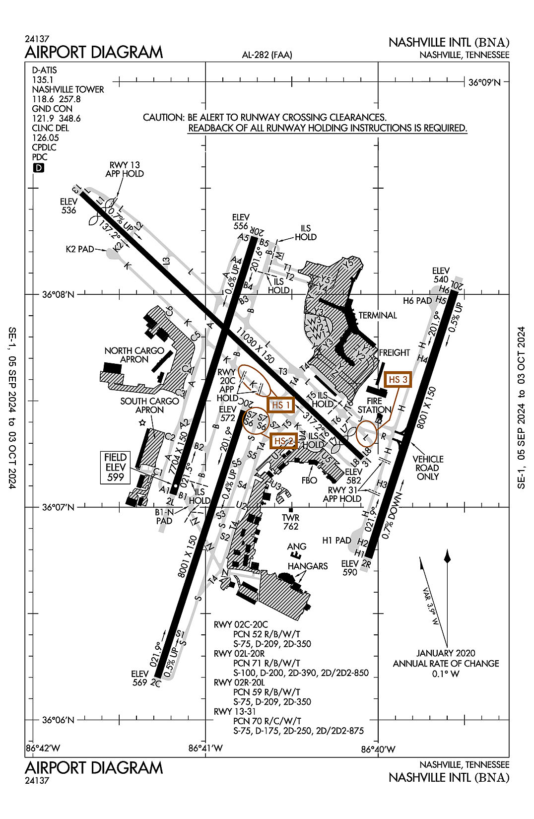
AD 2.2 Aerodrome Geographical and Administrative Data
2.2.1 Reference Point: 36-07-28.11N / 86-40-41.45W
2.2.2 From City: 5 miles SE of NASHVILLE, TN
2.2.3 Elevation: 599 ft
2.2.5 Magnetic Variation: 3W (2010)
2.2.6 Airport Contact: ADAM FLOYD
140 BNA PARK DR. SUITE 520
NASHVILLE, TN 37214 (615-275-1825)
2.2.7 Traffic: IFR/VFR
AD 2.3 Attendance Schedule
2.3.1 All Months, All Days, All Hours
AD 2.4 Handling Services and Facilities
2.4.1 Cargo Handling Facilities: YES
2.4.2 Fuel Types: 100LL A
2.4.5 Hangar Space: YES
2.4.6 Repair Facilities: MAJOR
AD 2.6 Rescue and Firefighting Services
2.6.1 Aerodrome Category: Class-I certified on 5/1/1973
2.6.2 Rescue and Firefighting Services: ARFF Index-D
AD 2.12 Runway Physical Characteristics
2.12.1 Designation: 02C
2.12.2 True Bearing: 18
2.12.3 True Dimensions: 8001 ft x 150 ft
2.12.4 PCN: 52 R/B/W/T
2.12.5 Coordinates: 36-06-11.9899N / 86-41-16.6591W
2.12.6 Threshold Elevation: 569.1
2.12.6 Touchdown Zone Elevation: 586.7
2.12.1 Designation: 20C
2.12.2 True Bearing: 198
2.12.3 True Dimensions: 8001 ft x 150 ft
2.12.4 PCN: 52 R/B/W/T
2.12.5 Coordinates: 36-07-27.2406N / 86-40-46.55W
2.12.6 Threshold Elevation: 571.8
2.12.6 Touchdown Zone Elevation: 587.7
2.12.1 Designation: 02L
2.12.2 True Bearing: 18
2.12.3 True Dimensions: 7704 ft x 150 ft
2.12.4 PCN: 71 R/B/W/T
2.12.5 Coordinates: 36-07-03.6342N / 86-41-11.3105W
2.12.6 Threshold Elevation: 598.7
2.12.6 Touchdown Zone Elevation: 599
2.12.1 Designation: 20R
2.12.2 True Bearing: 198
2.12.3 True Dimensions: 7704 ft x 150 ft
2.12.4 PCN: 71 R/B/W/T
2.12.5 Coordinates: 36-08-16.2324N / 86-40-42.8335W
2.12.6 Threshold Elevation: 555.6
2.12.6 Touchdown Zone Elevation: 578
2.12.1 Designation: 02R
2.12.2 True Bearing: 18
2.12.3 True Dimensions: 8001 ft x 150 ft
2.12.4 PCN: 59 R/B/W/T
2.12.5 Coordinates: 36-06-45.767N / 86-40-03.5138W
2.12.6 Threshold Elevation: 589.8
2.12.6 Touchdown Zone Elevation: 589.8
2.12.1 Designation: 20L
2.12.2 True Bearing: 198
2.12.3 True Dimensions: 8001 ft x 150 ft
2.12.4 PCN: 59 R/B/W/T
2.12.5 Coordinates: 36-08-01.0116N / 86-39-33.3955W
2.12.6 Threshold Elevation: 540
2.12.6 Touchdown Zone Elevation: 550.6
2.12.1 Designation: 13
2.12.2 True Bearing: 133
2.12.3 True Dimensions: 11030 ft x 150 ft
2.12.4 PCN: 70 R/C/W/T
2.12.5 Coordinates: 36-08-28.5991N / 86-41-43.2788W
2.12.6 Threshold Elevation: 535.9
2.12.6 Touchdown Zone Elevation: 567.5
2.12.1 Designation: 31
2.12.2 True Bearing: 313
2.12.3 True Dimensions: 11030 ft x 150 ft
2.12.4 PCN: 70 R/C/W/T
2.12.5 Coordinates: 36-07-13.7852N / 86-40-05.4384W
2.12.6 Threshold Elevation: 582.3
2.12.6 Touchdown Zone Elevation: 577.5
AD 2.13 Declared Distances
2.13.1 Designation: 02C
2.13.2 Take-off Run Available: 8001
2.13.3 Take-off Distance Available: 8001
2.13.4 Accelerate-Stop Distance Available: 7601
2.13.5 Landing Distance Available: 7601
2.13.1 Designation: 20C
2.13.2 Take-off Run Available: 8001
2.13.3 Take-off Distance Available: 8001
2.13.4 Accelerate-Stop Distance Available: 8001
2.13.5 Landing Distance Available: 8001
2.13.1 Designation: 02L
2.13.2 Take-off Run Available: 7702
2.13.3 Take-off Distance Available: 7702
2.13.4 Accelerate-Stop Distance Available: 7702
2.13.5 Landing Distance Available: 7702
2.13.1 Designation: 20R
2.13.2 Take-off Run Available: 7702
2.13.3 Take-off Distance Available: 7702
2.13.4 Accelerate-Stop Distance Available: 7702
2.13.5 Landing Distance Available: 7702
2.13.1 Designation: 02R
2.13.2 Take-off Run Available: 8000
2.13.3 Take-off Distance Available: 8000
2.13.4 Accelerate-Stop Distance Available: 8000
2.13.5 Landing Distance Available: 8000
2.13.1 Designation: 20L
2.13.2 Take-off Run Available: 8000
2.13.3 Take-off Distance Available: 8000
2.13.4 Accelerate-Stop Distance Available: 8000
2.13.5 Landing Distance Available: 8000
2.13.1 Designation: 13
2.13.2 Take-off Run Available: 10288
2.13.3 Take-off Distance Available: 11029
2.13.4 Accelerate-Stop Distance Available: 10288
2.13.5 Landing Distance Available: 9487
2.13.1 Designation: 31
2.13.2 Take-off Run Available: 10228
2.13.3 Take-off Distance Available: 11029
2.13.4 Accelerate-Stop Distance Available: 10228
2.13.5 Landing Distance Available: 9487
AD 2.14 Approach and Runway Lighting
2.14.1 Designation: 02C
2.14.2 Approach Lighting System: MALSR
2.14.4 Visual Approach Slope Indicator System:
2.14.1 Designation: 20C
2.14.2 Approach Lighting System:
2.14.4 Visual Approach Slope Indicator System: P4L
2.14.1 Designation: 02L
2.14.2 Approach Lighting System: ALSF2
2.14.4 Visual Approach Slope Indicator System: P4R
2.14.1 Designation: 20R
2.14.2 Approach Lighting System: MALSF
2.14.4 Visual Approach Slope Indicator System: P4R
2.14.1 Designation: 02R
2.14.2 Approach Lighting System: ALSF2
2.14.4 Visual Approach Slope Indicator System:
2.14.1 Designation: 20L
2.14.2 Approach Lighting System: MALSR
2.14.4 Visual Approach Slope Indicator System:
2.14.1 Designation: 13
2.14.2 Approach Lighting System:
2.14.4 Visual Approach Slope Indicator System:
2.14.1 Designation: 31
2.14.2 Approach Lighting System:
2.14.4 Visual Approach Slope Indicator System: P4R
AD 2.18 Air Traffic Services Communication Facilities
2.18.1 Service Designation: ALCP
2.18.3 Channel: 314.4
2.18.5 Hours of Operation:
2.18.1 Service Designation: APCH/P (WEST)
2.18.3 Channel: 372
2.18.5 Hours of Operation: 24
2.18.1 Service Designation: APCH/P IC (EAST)
2.18.3 Channel: 118.4
2.18.5 Hours of Operation: 24
2.18.1 Service Designation: APCH/P IC (EAST)
2.18.3 Channel: 360.7
2.18.5 Hours of Operation: 24
2.18.1 Service Designation: CD PRE TAXI CLNC
2.18.3 Channel: 126.05
2.18.5 Hours of Operation: 24
2.18.1 Service Designation: CLASS C (EAST)
2.18.3 Channel: 118.4
2.18.5 Hours of Operation: 24
2.18.1 Service Designation: CLASS C (WEST)
2.18.3 Channel: 119.35
2.18.5 Hours of Operation: 24
2.18.1 Service Designation: CLASS C (EAST)
2.18.3 Channel: 360.7
2.18.5 Hours of Operation: 24
2.18.1 Service Designation: CLASS C (WEST)
2.18.3 Channel: 372
2.18.5 Hours of Operation: 24
2.18.1 Service Designation: D-ATIS
2.18.3 Channel: 135.1
2.18.5 Hours of Operation: 24
2.18.1 Service Designation: DEP/P (EAST)
2.18.3 Channel: 118.4
2.18.5 Hours of Operation: 24
2.18.1 Service Designation: DEP/P (WEST)
2.18.3 Channel: 119.35
2.18.5 Hours of Operation: 24
2.18.1 Service Designation: DEP/P (EAST)
2.18.3 Channel: 360.7
2.18.5 Hours of Operation: 24
2.18.1 Service Designation: DEP/P (WEST)
2.18.3 Channel: 372
2.18.5 Hours of Operation: 24
2.18.1 Service Designation: EMERG
2.18.3 Channel: 121.5
2.18.5 Hours of Operation:
2.18.1 Service Designation: EMERG
2.18.3 Channel: 243
2.18.5 Hours of Operation:
2.18.1 Service Designation: GND/P
2.18.3 Channel: 121.9
2.18.5 Hours of Operation: 24
2.18.1 Service Designation: GND/P
2.18.3 Channel: 348.6
2.18.5 Hours of Operation: 24
2.18.1 Service Designation: LCL/P
2.18.3 Channel: 118.6
2.18.5 Hours of Operation: 24
2.18.1 Service Designation: LCL/P
2.18.3 Channel: 257.8
2.18.5 Hours of Operation: 24
AD 2.19 Radio Navigation and Landing Aids
2.19.1 ILS Type: Glide Slop for runway 02C. Magnetic variation: 3W
2.19.2 ILS Identification: EZN
2.19.5 Coordinates: 36-06-22.6382N / 86-41-16.8861W
2.19.6 Site Elevation: 570.5 ft
2.19.1 ILS Type: Localizer for runway 02C. Magnetic variation: 3W
2.19.2 ILS Identification: EZN
2.19.5 Coordinates: 36-07-32.9571N / 86-40-44.2611W
2.19.6 Site Elevation: 574.3 ft
2.19.1 ILS Type: DME for runway 02L. Magnetic variation: 3W
2.19.2 ILS Identification: BNA
2.19.5 Coordinates: 36-08-26.4864N / 86-40-42.3692W
2.19.6 Site Elevation: 554 ft
2.19.1 ILS Type: Glide Slop for runway 02L. Magnetic variation: 3W
2.19.2 ILS Identification: BNA
2.19.5 Coordinates: 36-07-12.9535N / 86-41-02.539W
2.19.6 Site Elevation: 589.7 ft
2.19.1 ILS Type: Inner Marker for runway 02L. Magnetic variation: 3W
2.19.2 ILS Identification: BNA
2.19.5 Coordinates: 36-06-54.829N / 86-41-14.7612W
2.19.6 Site Elevation: 594.5 ft
2.19.1 ILS Type: Localizer for runway 02L. Magnetic variation: 3W
2.19.2 ILS Identification: BNA
2.19.5 Coordinates: 36-08-25.7779N / 86-40-39.0927W
2.19.6 Site Elevation: 545.4 ft
2.19.1 ILS Type: Glide Slop for runway 20R. Magnetic variation: 3W
2.19.2 ILS Identification: VIY
2.19.5 Coordinates: 36-08-05.8196N / 86-40-42.7621W
2.19.6 Site Elevation: 554.9 ft
2.19.1 ILS Type: Localizer for runway 20R. Magnetic variation: 3W
2.19.2 ILS Identification: VIY
2.19.5 Coordinates: 36-06-49.6756N / 86-41-16.7814W
2.19.6 Site Elevation: 598.1 ft
2.19.1 ILS Type: DME for runway 02R. Magnetic variation: 3W
2.19.2 ILS Identification: UQU
2.19.5 Coordinates: 36-08-09.8916N / 86-39-35.7867W
2.19.6 Site Elevation: 537.1 ft
2.19.1 ILS Type: Glide Slop for runway 02R. Magnetic variation: 3W
2.19.2 ILS Identification: UQU
2.19.5 Coordinates: 36-06-56.0152N / 86-39-54.7364W
2.19.6 Site Elevation: 576.7 ft
2.19.1 ILS Type: Inner Marker for runway 02R. Magnetic variation: 3W
2.19.2 ILS Identification: UQU
2.19.5 Coordinates: 36-06-37.6961N / 86-40-06.7484W
2.19.6 Site Elevation: 569 ft
2.19.1 ILS Type: Localizer for runway 02R. Magnetic variation: 3W
2.19.2 ILS Identification: UQU
2.19.5 Coordinates: 36-08-10.5404N / 86-39-29.5803W
2.19.6 Site Elevation: 531 ft
2.19.1 ILS Type: DME for runway 20L. Magnetic variation: 3W
2.19.2 ILS Identification: SSX
2.19.5 Coordinates: 36-06-30.9674N / 86-40-12.8854W
2.19.6 Site Elevation: 622.2 ft
2.19.1 ILS Type: Glide Slop for runway 20L. Magnetic variation: 3W
2.19.2 ILS Identification: SSX
2.19.5 Coordinates: 36-07-50.0286N / 86-39-33.1134W
2.19.6 Site Elevation: 534.5 ft
2.19.1 ILS Type: Localizer for runway 20L. Magnetic variation: 3W
2.19.2 ILS Identification: SSX
2.19.5 Coordinates: 36-06-30.0253N / 86-40-09.8136W
2.19.6 Site Elevation: 613.4 ft
2.19.1 ILS Type: Glide Slop for runway 31. Magnetic variation: 3W
2.19.2 ILS Identification: PNO
2.19.5 Coordinates: 36-07-28.2722N / 86-40-18.5978W
2.19.6 Site Elevation: 566.4 ft
2.19.1 ILS Type: Localizer for runway 31. Magnetic variation: 3W
2.19.2 ILS Identification: PNO
2.19.5 Coordinates: 36-08-30.6518N / 86-41-45.9626W
2.19.6 Site Elevation: 539.6 ft
2.19.1 Navigation Aid Type VORTAC. Magnetic variation: 2W
2.19.2 Navigation Aid Identification: BNA
2.19.5 Coordinates: 36-08-13.0573N / 86-41-05.1762W
2.19.6 Site Elevation: 566.4 ft
General Remarks:
RWY 2L-20R, 2C-20C, 2R-20L, 13-31 CTL MRKGS AND LEAD OFF/ON MRKGS IN TDZ OBSC DUE TO RUBBER BUILD-UP
PAVEMENT ON W SIDE OF RWY 2R/20L BTN TXY H3 & H4 MKD AS A VEHICLE ACES ROAD ONLY.
TBJT RWY NOISE ABATEMENT PROC; MIL TBJT USE RWY 13/31 FOR ARR & DEP.
CTN: READ BACK & COMPLIANCE OF RWY HLDG INSTRN RQR; SPCLY TWY K & RWY 20C, TWY L AT RWY 13 & TWY H AT RWY 31.
TRML RAMP OPS TRML B GATE B6, B8, B10, TRML C GATE C13-C15 & TRML T GATE T1-T6 PPR BFR RAMP ENTRY OR PUSHBACK 0500-2300 - 131.375.
MIL & ACFT MORE THAN 12500 LB PRAC APCH NA; PRAC APCH BTN 2300-0700 NA.
DO NOT CONFUSE TWY S FOR RWY 20C.
BIRD ACT ON & INVOF ARPT.
TRML APRON TXL Z, Y1, Y2 & TXL Y BTN TXL Y3 & Y4 CLSD TO WINGSPAN MORE THAN 118 FT.
TRML APRON TAX BTN ACR PUSHBACK OPS & GATES NA.
ANG: PPR - MUSIC CITY OPS 615-367-5579.
180 DEG TURNS OVR 12500 LBS NA ON ASPH SFC.
TRML RAMP OPS TRML D GATE D1-D6 & TRML C GATE C1-C11 & GATE C16-C27 PPR BFR RAMP ENTRY OR PUSHBACK 0500-2300 - 129.95.
FLT NOTIFICATION SVC (ADCUS) AVBL.
TRML RAMP, N TRML RAMP & NON-MOVMT AREA UNCTLD; BFR USE - 122.95.
FLT OVR MAIN TRML NA.
ADHERE TO TWY & TXL CNTRLN WI TRML APRON.