North Carolina
Charlotte, North Carolina
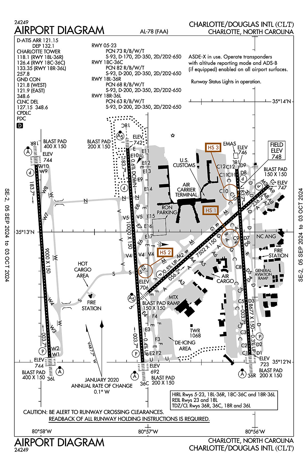
Charlotte/Douglas International
ICAO Identifier KCLT
Charlotte, NC
Charlotte/Douglas Intl
ICAO Identifier KCLT
AD 2.2 Aerodrome Geographical and Administrative Data
2.2.1 Reference Point: 35-12-49.5N / 80-56-56.6W
2.2.2 From City: 5 miles W of CHARLOTTE, NC
2.2.3 Elevation: 747.9 ft
2.2.5 Magnetic Variation: 7W (2000)
2.2.6 Airport Contact: HALEY GENTRY
5601 WILKINSON BLVD.
CHARLOTTE, NC 28208 (704-359-4000)
2.2.7 Traffic: IFR/VFR
AD 2.3 Attendance Schedule
2.3.1 All Months, All Days, All Hours
AD 2.4 Handling Services and Facilities
2.4.1 Cargo Handling Facilities: YES
2.4.2 Fuel Types: 100LL A
2.4.5 Hangar Space:
2.4.6 Repair Facilities: MAJOR
AD 2.6 Rescue and Firefighting Services
2.6.1 Aerodrome Category: Class-I certified on 5/1/1973
2.6.2 Rescue and Firefighting Services: ARFF Index-E
AD 2.12 Runway Physical Characteristics
2.12.1 Designation: 23
2.12.2 True Bearing: 228
2.12.3 True Dimensions: 7502 ft x 150 ft
2.12.4 PCN: 73 R/B/W/T
2.12.5 Coordinates: 35-13-21.4183N / 80-55-52.1235W
2.12.6 Threshold Elevation: 746.7
2.12.6 Touchdown Zone Elevation: 746.7
2.12.1 Designation: 05
2.12.2 True Bearing: 48
2.12.3 True Dimensions: 7502 ft x 150 ft
2.12.4 PCN: 73 R/B/W/T
2.12.5 Coordinates: 35-12-32.2287N / 80-56-59.8045W
2.12.6 Threshold Elevation: 705.9
2.12.6 Touchdown Zone Elevation: 715.6
2.12.1 Designation: 18C
2.12.2 True Bearing: 176
2.12.3 True Dimensions: 10000 ft x 150 ft
2.12.4 PCN: 82 R/B/W/T
2.12.5 Coordinates: 35-13-38.6269N / 80-57-11.4094W
2.12.6 Threshold Elevation: 742
2.12.6 Touchdown Zone Elevation: 742
2.12.1 Designation: 36C
2.12.2 True Bearing: 356
2.12.3 True Dimensions: 10000 ft x 150 ft
2.12.4 PCN: 82 R/B/W/T
2.12.5 Coordinates: 35-11-59.9721N / 80-57-02.9217W
2.12.6 Threshold Elevation: 692.2
2.12.6 Touchdown Zone Elevation: 706.7
2.12.1 Designation: 18L
2.12.2 True Bearing: 176
2.12.3 True Dimensions: 8677 ft x 150 ft
2.12.4 PCN: 68 R/B/W/T
2.12.5 Coordinates: 35-13-29.0474N / 80-56-10.1652W
2.12.6 Threshold Elevation: 746
2.12.6 Touchdown Zone Elevation: 747.9
2.12.1 Designation: 36R
2.12.2 True Bearing: 356
2.12.3 True Dimensions: 8677 ft x 150 ft
2.12.4 PCN: 68 R/B/W/T
2.12.5 Coordinates: 35-12-03.4456N / 80-56-02.822W
2.12.6 Threshold Elevation: 723.4
2.12.6 Touchdown Zone Elevation: 726.9
2.12.1 Designation: 36L
2.12.2 True Bearing: 356
2.12.3 True Dimensions: 9000 ft x 150 ft
2.12.4 PCN: 63 R/B/W/T
2.12.5 Coordinates: 35-12-02.2277N / 80-57-55.0671W
2.12.6 Threshold Elevation: 743.9
2.12.6 Touchdown Zone Elevation: 743.9
2.12.1 Designation: 18R
2.12.2 True Bearing: 176
2.12.3 True Dimensions: 9000 ft x 150 ft
2.12.4 PCN: 63 R/B/W/T
2.12.5 Coordinates: 35-13-31.0182N / 80-58-02.707W
2.12.6 Threshold Elevation: 744
2.12.6 Touchdown Zone Elevation: 744
AD 2.13 Declared Distances
2.13.1 Designation: 23
2.13.2 Take-off Run Available: 7502
2.13.3 Take-off Distance Available: 7502
2.13.4 Accelerate-Stop Distance Available: 7502
2.13.5 Landing Distance Available: 7502
2.13.1 Designation: 05
2.13.2 Take-off Run Available: 7502
2.13.3 Take-off Distance Available: 7502
2.13.4 Accelerate-Stop Distance Available: 7092
2.13.5 Landing Distance Available: 7092
2.13.1 Designation: 18C
2.13.2 Take-off Run Available: 10000
2.13.3 Take-off Distance Available: 10000
2.13.4 Accelerate-Stop Distance Available: 10000
2.13.5 Landing Distance Available: 10000
2.13.1 Designation: 36C
2.13.2 Take-off Run Available: 10000
2.13.3 Take-off Distance Available: 10000
2.13.4 Accelerate-Stop Distance Available: 10000
2.13.5 Landing Distance Available: 10000
2.13.1 Designation: 18L
2.13.2 Take-off Run Available: 8676
2.13.3 Take-off Distance Available: 8676
2.13.4 Accelerate-Stop Distance Available: 8676
2.13.5 Landing Distance Available: 8676
2.13.1 Designation: 36R
2.13.2 Take-off Run Available: 8676
2.13.3 Take-off Distance Available: 8676
2.13.4 Accelerate-Stop Distance Available: 8390
2.13.5 Landing Distance Available: 8390
2.13.1 Designation: 36L
2.13.2 Take-off Run Available: 9000
2.13.3 Take-off Distance Available: 9000
2.13.4 Accelerate-Stop Distance Available: 9000
2.13.5 Landing Distance Available: 9000
2.13.1 Designation: 18R
2.13.2 Take-off Run Available: 9000
2.13.3 Take-off Distance Available: 9000
2.13.4 Accelerate-Stop Distance Available: 9000
2.13.5 Landing Distance Available: 9000
AD 2.14 Approach and Runway Lighting
2.14.1 Designation: 23
2.14.2 Approach Lighting System:
2.14.4 Visual Approach Slope Indicator System: P4R
2.14.1 Designation: 05
2.14.2 Approach Lighting System: MALSR
2.14.4 Visual Approach Slope Indicator System: P4L
2.14.1 Designation: 18C
2.14.2 Approach Lighting System: MALSR
2.14.4 Visual Approach Slope Indicator System: P4R
2.14.1 Designation: 36C
2.14.2 Approach Lighting System: ALSF2
2.14.4 Visual Approach Slope Indicator System: P4L
2.14.1 Designation: 18L
2.14.2 Approach Lighting System:
2.14.4 Visual Approach Slope Indicator System: P4L
2.14.1 Designation: 36R
2.14.2 Approach Lighting System: ALSF2
2.14.4 Visual Approach Slope Indicator System: P4R
2.14.1 Designation: 36L
2.14.2 Approach Lighting System: ALSF2
2.14.4 Visual Approach Slope Indicator System: P4L
2.14.1 Designation: 18R
2.14.2 Approach Lighting System: ALSF2
2.14.4 Visual Approach Slope Indicator System: P4R
AD 2.18 Air Traffic Services Communication Facilities
2.18.1 Service Designation: ALCP
2.18.3 Channel: 292.25
2.18.5 Hours of Operation:
2.18.1 Service Designation: APCH/P
2.18.3 Channel: 126.15
2.18.5 Hours of Operation: 24
2.18.1 Service Designation: APCH/P DEP/P IC (120-295 8000 FT & BLW)
2.18.3 Channel: 120.05
2.18.5 Hours of Operation: 24
2.18.1 Service Designation: APCH/P DEP/P IC (246-074 ABV 8000 FT)
2.18.3 Channel: 120.5
2.18.5 Hours of Operation: 24
2.18.1 Service Designation: APCH/P DEP/P IC (075-245 ABV 8000 FT)
2.18.3 Channel: 124
2.18.5 Hours of Operation: 24
2.18.1 Service Designation: APCH/P DEP/P IC (001-119 8000 FT & BLW)
2.18.3 Channel: 128.325
2.18.5 Hours of Operation: 24
2.18.1 Service Designation: APCH/P DEP/P IC (296-360 8000 FT & BLW)
2.18.3 Channel: 134.75
2.18.5 Hours of Operation: 24
2.18.1 Service Designation: APCH/P DEP/P IC (180-359)
2.18.3 Channel: 257.2
2.18.5 Hours of Operation: 24
2.18.1 Service Designation: APCH/P DEP/P IC (360-179)
2.18.3 Channel: 307.8
2.18.5 Hours of Operation: 24
2.18.1 Service Designation: BANKR STAR
2.18.3 Channel: 135.6
2.18.5 Hours of Operation: 24
2.18.1 Service Designation: BANKR STAR
2.18.3 Channel: 377.15
2.18.5 Hours of Operation: 24
2.18.1 Service Designation: BARMY DP
2.18.3 Channel: 124
2.18.5 Hours of Operation: 24
2.18.1 Service Designation: BARMY DP
2.18.3 Channel: 307.8
2.18.5 Hours of Operation: 24
2.18.1 Service Designation: BEAVY DP (RWY 36L, 36C)
2.18.3 Channel: 120.5
2.18.5 Hours of Operation: 24
2.18.1 Service Designation: BEAVY DP (RWY 18L, 18R, 18C, 36R)
2.18.3 Channel: 124
2.18.5 Hours of Operation: 24
2.18.1 Service Designation: BEAVY DP (RWY 36L, 36C)
2.18.3 Channel: 257.2
2.18.5 Hours of Operation: 24
2.18.1 Service Designation: BEAVY DP (RWY 18R, 18L, 18C, 36R)
2.18.3 Channel: 307.8
2.18.5 Hours of Operation: 24
2.18.1 Service Designation: BOBZY DP
2.18.3 Channel: 120.5
2.18.5 Hours of Operation: 24
2.18.1 Service Designation: BOBZY DP
2.18.3 Channel: 257.2
2.18.5 Hours of Operation: 24
2.18.1 Service Designation: BTSEY STAR
2.18.3 Channel: 125.35
2.18.5 Hours of Operation: 24
2.18.1 Service Designation: CD/P
2.18.3 Channel: 127.15
2.18.5 Hours of Operation: 24
2.18.1 Service Designation: CD/P
2.18.3 Channel: 348.6
2.18.5 Hours of Operation: 24
2.18.1 Service Designation: CHARLOTTE DP (BUCKL TRANSITION, RWY 18L, 18R, 18C, 36R)
2.18.3 Channel: 307.8
2.18.5 Hours of Operation: 24
2.18.1 Service Designation: CHARLOTTE DP (HARAY & PITTY TRANSITIONS. RWY 36L, 36C)
2.18.3 Channel: 120.5
2.18.5 Hours of Operation: 24
2.18.1 Service Designation: CHARLOTTE DP (BUCKL, GANTS, LILLS & RUNIE TRANSITIONS.)
2.18.3 Channel: 124
2.18.5 Hours of Operation: 24
2.18.1 Service Designation: CHARLOTTE DP (RWY 18L, 18R, 18C, 36R)
2.18.3 Channel: 124
2.18.5 Hours of Operation: 24
2.18.1 Service Designation: CHARLOTTE DP (HARAY & PITTY TRANSITION. RWY 36L, 36C)
2.18.3 Channel: 257.2
2.18.5 Hours of Operation: 24
2.18.1 Service Designation: CHARLOTTE DP (GANTS, LILLS & RUNIE TRANSITIONS)
2.18.3 Channel: 307.8
2.18.5 Hours of Operation: 24
2.18.1 Service Designation: CHSLY STAR
2.18.3 Channel: 126.15
2.18.5 Hours of Operation: 24
2.18.1 Service Designation: CHSLY STAR
2.18.3 Channel: 282.325
2.18.5 Hours of Operation: 24
2.18.1 Service Designation: CLASS B (120-295 8000 FT & BLW)
2.18.3 Channel: 120.05
2.18.5 Hours of Operation: 24
2.18.1 Service Designation: CLASS B (246-074 ABV 8000 FT)
2.18.3 Channel: 120.5
2.18.5 Hours of Operation: 24
2.18.1 Service Designation: CLASS B (075-245 ABV 8000 FT)
2.18.3 Channel: 124
2.18.5 Hours of Operation: 24
2.18.1 Service Designation: CLASS B (001-119 8000 FT & BLW)
2.18.3 Channel: 128.325
2.18.5 Hours of Operation: 24
2.18.1 Service Designation: CLASS B (296-360 8000 FT & BLW)
2.18.3 Channel: 134.75
2.18.5 Hours of Operation: 24
2.18.1 Service Designation: CLASS B (180-359)
2.18.3 Channel: 257.2
2.18.5 Hours of Operation: 24
2.18.1 Service Designation: CLASS B (360-179)
2.18.3 Channel: 307.8
2.18.5 Hours of Operation: 24
2.18.1 Service Designation: D-ATIS (ARR)
2.18.3 Channel: 121.15
2.18.5 Hours of Operation: 24
2.18.1 Service Designation: D-ATIS (DEP)
2.18.3 Channel: 132.1
2.18.5 Hours of Operation: 24
2.18.1 Service Designation: EMERG
2.18.3 Channel: 121.5
2.18.5 Hours of Operation:
2.18.1 Service Designation: EMERG
2.18.3 Channel: 243
2.18.5 Hours of Operation:
2.18.1 Service Designation: ESTRR DP
2.18.3 Channel: 120.5
2.18.5 Hours of Operation: 24
2.18.1 Service Designation: ESTRR DP
2.18.3 Channel: 257.2
2.18.5 Hours of Operation: 24
2.18.1 Service Designation: FILPZ STAR
2.18.3 Channel: 125.35
2.18.5 Hours of Operation: 24
2.18.1 Service Designation: FILPZ STAR
2.18.3 Channel: 257.2
2.18.5 Hours of Operation: 24
2.18.1 Service Designation: GND/P (WEST)
2.18.3 Channel: 121.8
2.18.5 Hours of Operation: 24
2.18.1 Service Designation: GND/P (EAST)
2.18.3 Channel: 121.9
2.18.5 Hours of Operation: 24
2.18.1 Service Designation: GND/P
2.18.3 Channel: 348.6
2.18.5 Hours of Operation: 24
2.18.1 Service Designation: ICONS DP (RWY 36L, 36C)
2.18.3 Channel: 120.5
2.18.5 Hours of Operation: 24
2.18.1 Service Designation: ICONS DP (RWY 18L, 18R, 18C, 36R)
2.18.3 Channel: 124
2.18.5 Hours of Operation: 24
2.18.1 Service Designation: ICONS DP (RWY 36L, 36C)
2.18.3 Channel: 257.2
2.18.5 Hours of Operation: 24
2.18.1 Service Designation: ICONS DP (RWY 18R, 18L, 18C, 36R)
2.18.3 Channel: 307.8
2.18.5 Hours of Operation: 24
2.18.1 Service Designation: JOJJO DP
2.18.3 Channel: 120.5
2.18.5 Hours of Operation: 24
2.18.1 Service Designation: JOJJO DP
2.18.3 Channel: 257.2
2.18.5 Hours of Operation: 24
2.18.1 Service Designation: JONZE STAR
2.18.3 Channel: 135.6
2.18.5 Hours of Operation: 24
2.18.1 Service Designation: JONZE STAR
2.18.3 Channel: 377.15
2.18.5 Hours of Operation: 24
2.18.1 Service Designation: JOOLS STAR
2.18.3 Channel: 135.6
2.18.5 Hours of Operation: 24
2.18.1 Service Designation: JOOLS STAR
2.18.3 Channel: 377.15
2.18.5 Hours of Operation: 24
2.18.1 Service Designation: KERMIT DP (235-055)
2.18.3 Channel: 120.5
2.18.5 Hours of Operation: 24
2.18.1 Service Designation: KERMIT DP (055-235)
2.18.3 Channel: 124
2.18.5 Hours of Operation: 24
2.18.1 Service Designation: KERMIT DP (235-055)
2.18.3 Channel: 257.2
2.18.5 Hours of Operation: 24
2.18.1 Service Designation: KERMIT DP (055-235)
2.18.3 Channel: 307.8
2.18.5 Hours of Operation: 24
2.18.1 Service Designation: KILNS DP
2.18.3 Channel: 124
2.18.5 Hours of Operation: 24
2.18.1 Service Designation: KILNS DP
2.18.3 Channel: 307.8
2.18.5 Hours of Operation: 24
2.18.1 Service Designation: KNIGHTS DP (DEBIE, NEANO TRANSITIONS)
2.18.3 Channel: 120.05
2.18.5 Hours of Operation: 24
2.18.1 Service Designation: KNIGHTS DP (FLYYN, CEGAL TRANSITIONS, 18L, 18C, 18R)
2.18.3 Channel: 120.05
2.18.5 Hours of Operation: 24
2.18.1 Service Designation: KNIGHTS DP (FLYYN, CEGAL TRANSITIONS RWY 36L, 36C, 36R)
2.18.3 Channel: 120.5
2.18.5 Hours of Operation: 24
2.18.1 Service Designation: KNIGHTS DP (055-235)
2.18.3 Channel: 128.325
2.18.5 Hours of Operation: 24
2.18.1 Service Designation: KNIGHTS DP (PEKNN, LILLS, HAMLN, ANDYS TRANSITIONS)
2.18.3 Channel: 128.325
2.18.5 Hours of Operation: 24
2.18.1 Service Designation: KNIGHTS DP (235-055)
2.18.3 Channel: 257.2
2.18.5 Hours of Operation: 24
2.18.1 Service Designation: KNIGHTS DP (055-235)
2.18.3 Channel: 307.8
2.18.5 Hours of Operation: 24
2.18.1 Service Designation: KRITR DP
2.18.3 Channel: 120.5
2.18.5 Hours of Operation: 24
2.18.1 Service Designation: KRITR DP
2.18.3 Channel: 257.2
2.18.5 Hours of Operation: 24
2.18.1 Service Designation: KWEEN DP (RWY 36L, 36C)
2.18.3 Channel: 120.5
2.18.5 Hours of Operation: 24
2.18.1 Service Designation: KWEEN DP (RWY 18L, 18R, 18C, 36R)
2.18.3 Channel: 124
2.18.5 Hours of Operation: 24
2.18.1 Service Designation: KWEEN DP (RWY 36L, 36C)
2.18.3 Channel: 257.2
2.18.5 Hours of Operation: 24
2.18.1 Service Designation: KWEEN DP (RWY 18R, 18L, 18C, 36R)
2.18.3 Channel: 307.8
2.18.5 Hours of Operation: 24
2.18.1 Service Designation: LCL/P (RWY 18L/36R)
2.18.3 Channel: 118.1
2.18.5 Hours of Operation: 24
2.18.1 Service Designation: LCL/P (RWY 18C/36C)
2.18.3 Channel: 126.4
2.18.5 Hours of Operation: 24
2.18.1 Service Designation: LCL/P (RWY 18R/36L)
2.18.3 Channel: 133.35
2.18.5 Hours of Operation: 24
2.18.1 Service Designation: LCL/P
2.18.3 Channel: 257.8
2.18.5 Hours of Operation: 24
2.18.1 Service Designation: LIINN STAR
2.18.3 Channel: 125.35
2.18.5 Hours of Operation: 24
2.18.1 Service Designation: LIINN STAR
2.18.3 Channel: 257.2
2.18.5 Hours of Operation: 24
2.18.1 Service Designation: LILLS DP
2.18.3 Channel: 124
2.18.5 Hours of Operation: 24
2.18.1 Service Designation: LILLS DP
2.18.3 Channel: 307.8
2.18.5 Hours of Operation: 24
2.18.1 Service Designation: MAJIC STAR
2.18.3 Channel: 126.15
2.18.5 Hours of Operation: 24
2.18.1 Service Designation: MAJIC STAR
2.18.3 Channel: 282.325
2.18.5 Hours of Operation: 24
2.18.1 Service Designation: MLLET STAR
2.18.3 Channel: 126.15
2.18.5 Hours of Operation: 24
2.18.1 Service Designation: MLLET STAR
2.18.3 Channel: 282.325
2.18.5 Hours of Operation: 24
2.18.1 Service Designation: PARQR STAR
2.18.3 Channel: 125.35
2.18.5 Hours of Operation: 24
2.18.1 Service Designation: PARQR STAR
2.18.3 Channel: 257.2
2.18.5 Hours of Operation: 24
2.18.1 Service Designation: RASLN STAR
2.18.3 Channel: 126.15
2.18.5 Hours of Operation: 24
2.18.1 Service Designation: RASLN STAR
2.18.3 Channel: 282.325
2.18.5 Hours of Operation: 24
2.18.1 Service Designation: STOCR STAR
2.18.3 Channel: 126.15
2.18.5 Hours of Operation: 24
2.18.1 Service Designation: STOCR STAR
2.18.3 Channel: 282.325
2.18.5 Hours of Operation: 24
2.18.1 Service Designation: UNARM STAR
2.18.3 Channel: 135.6
2.18.5 Hours of Operation: 24
2.18.1 Service Designation: UNARM STAR
2.18.3 Channel: 377.15
2.18.5 Hours of Operation: 24
2.18.1 Service Designation: WEAZL DP
2.18.3 Channel: 120.5
2.18.5 Hours of Operation: 24
2.18.1 Service Designation: WEAZL DP
2.18.3 Channel: 257.2
2.18.5 Hours of Operation: 24
AD 2.19 Radio Navigation and Landing Aids
2.19.1 ILS Type: Glide Slop for runway 05. Magnetic variation: 7W
2.19.2 ILS Identification: CLT
2.19.5 Coordinates: 35-12-43.05N / 80-56-52.18W
2.19.6 Site Elevation: 695.1 ft
2.19.1 ILS Type: Localizer for runway 05. Magnetic variation: 7W
2.19.2 ILS Identification: CLT
2.19.5 Coordinates: 35-13-26.34N / 80-55-45.36W
2.19.6 Site Elevation: 738.2 ft
2.19.1 ILS Type: DME for runway 23. Magnetic variation: 7W
2.19.2 ILS Identification: APU
2.19.5 Coordinates: 35-12-21.2833N / 80-57-10.052W
2.19.6 Site Elevation: 699.4 ft
2.19.1 ILS Type: Glide Slop for runway 23. Magnetic variation: 7W
2.19.2 ILS Identification: APU
2.19.5 Coordinates: 35-13-12.1531N / 80-56-00.0758W
2.19.6 Site Elevation: 737.7 ft
2.19.1 ILS Type: Localizer for runway 23. Magnetic variation: 7W
2.19.2 ILS Identification: APU
2.19.5 Coordinates: 35-12-23.38N / 80-57-11.99W
2.19.6 Site Elevation: 704 ft
2.19.1 ILS Type: DME for runway 18C. Magnetic variation: 7W
2.19.2 ILS Identification: PEP
2.19.5 Coordinates: 35-11-50.2369N / 80-56-58.6363W
2.19.6 Site Elevation: 684.4 ft
2.19.1 ILS Type: Glide Slop for runway 18C. Magnetic variation: 7W
2.19.2 ILS Identification: PEP
2.19.5 Coordinates: 35-13-26.9102N / 80-57-15.2356W
2.19.6 Site Elevation: 731.4 ft
2.19.1 ILS Type: Localizer for runway 18C. Magnetic variation: 7W
2.19.2 ILS Identification: PEP
2.19.5 Coordinates: 35-11-48.5979N / 80-57-01.9439W
2.19.6 Site Elevation: 683.3 ft
2.19.1 ILS Type: Glide Slop for runway 36C. Magnetic variation: 7W
2.19.2 ILS Identification: DQG
2.19.5 Coordinates: 35-12-09.1687N / 80-57-08.5431W
2.19.6 Site Elevation: 691.1 ft
2.19.1 ILS Type: Inner Marker for runway 36C. Magnetic variation: 7W
2.19.2 ILS Identification: DQG
2.19.5 Coordinates: 35-11-48.7253N / 80-57-01.9507W
2.19.6 Site Elevation: 682.9 ft
2.19.1 ILS Type: Localizer for runway 36C. Magnetic variation: 7W
2.19.2 ILS Identification: DQG
2.19.5 Coordinates: 35-13-49.83N / 80-57-12.38W
2.19.6 Site Elevation: 748.3 ft
2.19.1 ILS Type: DME for runway 18L. Magnetic variation: 7W
2.19.2 ILS Identification: VKQ
2.19.5 Coordinates: 35-11-50.25N / 80-56-04.63W
2.19.6 Site Elevation: 710 ft
2.19.1 ILS Type: Glide Slop for runway 18L. Magnetic variation: 7W
2.19.2 ILS Identification: VKQ
2.19.5 Coordinates: 35-13-19.2609N / 80-56-05.097W
2.19.6 Site Elevation: 743.5 ft
2.19.1 ILS Type: Localizer for runway 18L. Magnetic variation: 7W
2.19.2 ILS Identification: VKQ
2.19.5 Coordinates: 35-11-50.5994N / 80-56-01.7186W
2.19.6 Site Elevation: 719.2 ft
2.19.1 ILS Type: DME for runway 36R. Magnetic variation: 7W
2.19.2 ILS Identification: BQC
2.19.5 Coordinates: 35-13-33.1089N / 80-56-06.903W
2.19.6 Site Elevation: 752.3 ft
2.19.1 ILS Type: Glide Slop for runway 36R. Magnetic variation: 7W
2.19.2 ILS Identification: BQC
2.19.5 Coordinates: 35-12-14.0034N / 80-55-58.8923W
2.19.6 Site Elevation: 717.3 ft
2.19.1 ILS Type: Localizer for runway 36R. Magnetic variation: 7W
2.19.2 ILS Identification: BQC
2.19.5 Coordinates: 35-13-33.7034N / 80-56-10.5664W
2.19.6 Site Elevation: 741.2 ft
2.19.1 ILS Type: DME for runway 18R. Magnetic variation: 7W
2.19.2 ILS Identification: RGS
2.19.5 Coordinates: 35-12-13.2565N / 80-58-01.0908W
2.19.6 Site Elevation: 743.8 ft
2.19.1 ILS Type: Glide Slop for runway 18R. Magnetic variation: 7W
2.19.2 ILS Identification: RGS
2.19.5 Coordinates: 35-13-20.0955N / 80-58-06.7207W
2.19.6 Site Elevation: 733.9 ft
2.19.1 ILS Type: Inner Marker for runway 18R. Magnetic variation: 7W
2.19.2 ILS Identification: RGS
2.19.5 Coordinates: 35-13-38.8124N / 80-58-03.3825W
2.19.6 Site Elevation: 738.6 ft
2.19.1 ILS Type: Localizer for runway 18R. Magnetic variation: 7W
2.19.2 ILS Identification: RGS
2.19.5 Coordinates: 35-11-51.8431N / 80-57-54.1735W
2.19.6 Site Elevation: 738.1 ft
2.19.1 ILS Type: DME for runway 36L. Magnetic variation: 7W
2.19.2 ILS Identification: XUU
2.19.5 Coordinates: 35-13-19.8318N / 80-58-06.8193W
2.19.6 Site Elevation: 738.9 ft
2.19.1 ILS Type: Glide Slop for runway 36L. Magnetic variation: 7W
2.19.2 ILS Identification: XUU
2.19.5 Coordinates: 35-12-12.9817N / 80-58-00.9403W
2.19.6 Site Elevation: 732.3 ft
2.19.1 ILS Type: Inner Marker for runway 36L. Magnetic variation: 7W
2.19.2 ILS Identification: XUU
2.19.5 Coordinates: 35-11-54.4339N / 80-57-54.3965W
2.19.6 Site Elevation: 738.8 ft
2.19.1 ILS Type: Localizer for runway 36L. Magnetic variation: 7W
2.19.2 ILS Identification: XUU
2.19.5 Coordinates: 35-13-41.4048N / 80-58-03.6016W
2.19.6 Site Elevation: 737.3 ft
2.19.1 Navigation Aid Type VOR/DME. Magnetic variation: 5W
2.19.2 Navigation Aid Identification: CLT
2.19.5 Coordinates: 35-11-25.0392N / 80-57-06.3124W
2.19.6 Site Elevation: 731.7 ft
General Remarks:
TWY C10 RSTRD TO ACFT WITH WINGSPAN LESS THAN 171 FT WHEN EXITING RWY.
GROUP VI ACFT WITH A WINGSPAN GTR THAN 214 FT (65M) ARE PROHIBITED ON TWY M BETWEEN THE TRML RAMP AND TWY C, AS WELL AS TWY C NORTH OF TWY M.
CLT RAMP, NON-MOVMT AREA, IS CTLD RAMP; CTC RAMP CTL PRIOR TO ENTERING.
TWY C10 UNUSBL FOR TXG ONTO RWY 18L/36R.
MILITARY: ANG: CTC COMD POST 30 MIN PRIOR LDG. AMOPS/COMD POST - 292.25 (CALL NEWSREEL).
SUCCESSIVE OR SIMULTANEOUS DEPARTURES FROM RWY 18L AND RWY 18C ARE APPROVED WITH COURSE DIVERGENCE BEGINNING NO FURTHER THAN 4 MILES FROM END OF RWY.
TRML RAMP ORANGE TXL AT SPOT 28N BETWEEN CONCOURSE D & E ALLEY MAX WINGSPAN 94 FT.
DUAL TAXI BTN DEP CALL SPOTS 11/12 AND 13N/13S RSTRD TO ONE ACFT LESS THAN 214 FT AND ONE ACFT LESS THAN 118 FT OR TWO ACFT LESS THAN 171 FT.
RWY SFC COND INFO DURG DUTY HRS PHONE ANG OPS V583-9177/9144 OR AIRBORNE 292.2.
TRML RAMP BLUE TXL AT SPOT 28S BTN CONCOURSE D & E ALLEY MAX WINGSPAN 118 FT.
DUAL TAXI BTN DEP CALL SPOTS 22/23 AND 24N/24S RSTRD TO ACFT WITH WINGSPANS LESS THAN 118 FT.
TRML RAMP BLUE TXL FROM SPOT 29W TO SPOT 34S MAX WINGSPAN 82 FT.
ALL ACFT ARE PROHIBITED FM EXITING RWY 36R SEBD AT TWY R.
RWY STATUS LGTS IN OPR.
TWY C4 AND C6: WHEN TAXIING AIRCRAFT WITH COCKPIT TO MAIN GEAR DISTANCE GREATER THAN 90 FT, PILOT MUST PERFORM JUDGEMENTAL OVERSTEERING INSTEAD OF COCKPIT OVER CENTERLINE STEERING.
TWY D, RESTRICTED TO 15 MPH OR LESS WITH WINGSPAN 171 FT AND GREATER.
AIRPLANE DESIGN GROUP-V AND ABV ACFT ARE PROHIBITED FM DEP RWY 18L.
TRML RAMP ORANGE TXL FROM SPOT 26S TO SPOT 27E MAX WINGSPAN 118 FT.
GROUP IV ACFT WITH A WINGSPAN GTR THAN 118 FT ARE PROHIBITED FM EXITING RWY 18L/36R AT TWY C10.
GROUP III ACFT WITH A WINGSPAN GTR THAN 79 FT ARE PROHIBITED FM MAKING A NBND TURN ONTO TWY C WHEN TAXIING WB ON TWY A.
TRML RAMP BLUE TXL FROM SPOT 26N TO SPOT 27W MAX WINGSPAN 118 FT.
BE ALERT FOR FLOCKS OF MIGRATORY BIRDS ON & INVOF ARPT.
GROUP III ACFT WITH A WINGSPAN GTR THAN 79 FT ARE PROHIBITED FM MAKING A SBND TURN ONTO TWY C WHEN TAXIING NWBND ON TWY R.
TWY C FROM THE APCH OF RWY 18L TO RWY 05/23, AND TWY M FROM THE APRON TO RWY 18L/36R RSTRD TO 15 MPH OR LESS WITH WINGSPAN 171 FT AND GTR.
TRML RAMP YELLOW TXL FROM SPOT 29C TO SPOT 33C MAX WINGSPAN 118 FT.
TRML RAMP ORANGE TXL FROM SPOT 29E TO SPOT 34N MAX WINGSPAN 82 FT.
Raleigh-Durham, North Carolina
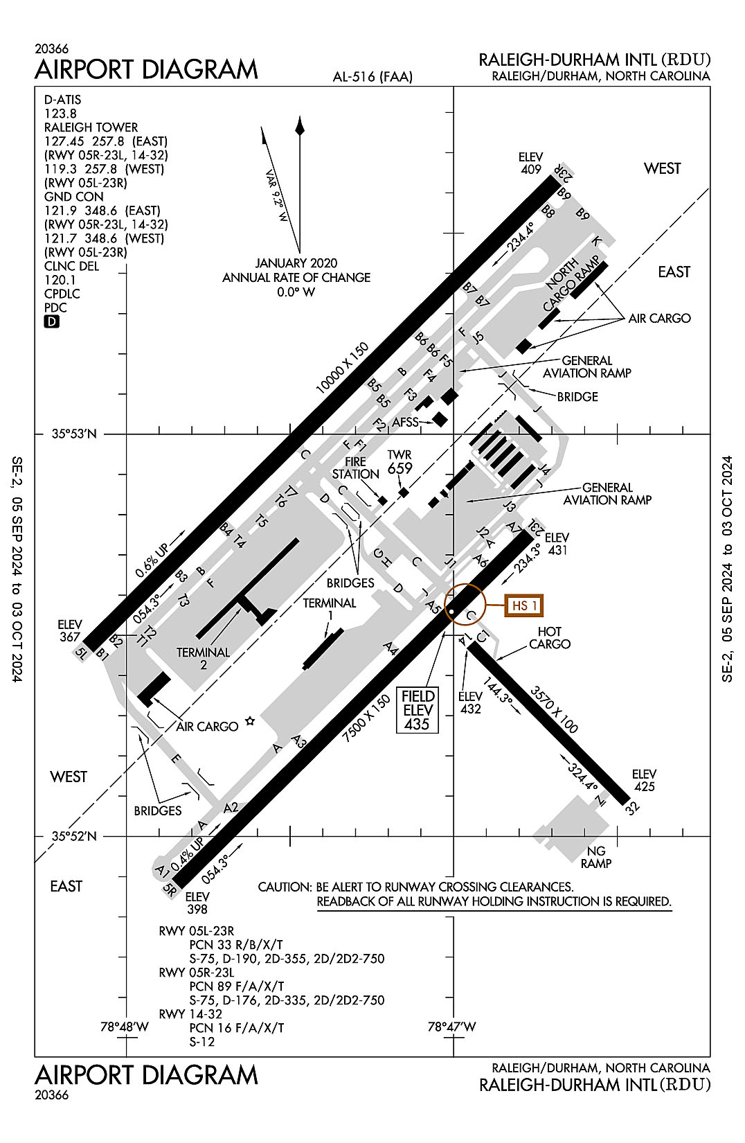
Raleigh-Durham International
ICAO Identifier KRDU
Raleigh/Durham, NC
Raleigh-Durham Intl
ICAO Identifier KRDU
AD 2.2 Aerodrome Geographical and Administrative Data
2.2.1 Reference Point: 35-52-39.5N / 78-47-14.9W
2.2.2 From City: 9 miles NW of RALEIGH/DURHAM, NC
2.2.3 Elevation: 435.2 ft
2.2.5 Magnetic Variation: 9W (2020)
2.2.6 Airport Contact: MICHAEL LANDGUTH
RALEIGH-DURHAM ARPT AUTH
RDU AIRPORT, NC 27623 ((919) 840-7701)
2.2.7 Traffic: IFR/VFR
AD 2.3 Attendance Schedule
2.3.1 All Months, All Days, All Hours
AD 2.4 Handling Services and Facilities
2.4.1 Cargo Handling Facilities: YES
2.4.2 Fuel Types: 100LL A
2.4.5 Hangar Space: YES
2.4.6 Repair Facilities: MAJOR
AD 2.6 Rescue and Firefighting Services
2.6.1 Aerodrome Category: Class-I certified on 5/1/1973
2.6.2 Rescue and Firefighting Services: ARFF Index-D
AD 2.12 Runway Physical Characteristics
2.12.1 Designation: 05L
2.12.2 True Bearing: 45
2.12.3 True Dimensions: 10000 ft x 150 ft
2.12.4 PCN: 33 R/B/X/T
2.12.5 Coordinates: 35-52-28.016N / 78-48-07.069W
2.12.6 Threshold Elevation: 366.8
2.12.6 Touchdown Zone Elevation: 384.3
2.12.1 Designation: 23R
2.12.2 True Bearing: 225
2.12.3 True Dimensions: 10000 ft x 150 ft
2.12.4 PCN: 33 R/B/X/T
2.12.5 Coordinates: 35-53-37.7657N / 78-46-40.9198W
2.12.6 Threshold Elevation: 408.6
2.12.6 Touchdown Zone Elevation: 408.6
2.12.1 Designation: 05R
2.12.2 True Bearing: 45
2.12.3 True Dimensions: 7500 ft x 150 ft
2.12.4 PCN: 89 F/A/X/T
2.12.5 Coordinates: 35-51-52.6684N / 78-47-50.4174W
2.12.6 Threshold Elevation: 397.5
2.12.6 Touchdown Zone Elevation: 419.8
2.12.1 Designation: 23L
2.12.2 True Bearing: 225
2.12.3 True Dimensions: 7500 ft x 150 ft
2.12.4 PCN: 89 F/A/X/T
2.12.5 Coordinates: 35-52-44.9832N / 78-46-45.8171W
2.12.6 Threshold Elevation: 430.7
2.12.6 Touchdown Zone Elevation: 435.2
2.12.1 Designation: 14
2.12.2 True Bearing: 135
2.12.3 True Dimensions: 3570 ft x 100 ft
2.12.4 PCN: 16 F/A/X/T
2.12.5 Coordinates: 35-52-30.1119N / 78-46-57.6427W
2.12.6 Threshold Elevation: 432.1
2.12.6 Touchdown Zone Elevation: 432.1
2.12.1 Designation: 32
2.12.2 True Bearing: 315
2.12.3 True Dimensions: 3570 ft x 100 ft
2.12.4 PCN: 16 F/A/X/T
2.12.5 Coordinates: 35-52-05.0792N / 78-46-27.0499W
2.12.6 Threshold Elevation: 424.7
2.12.6 Touchdown Zone Elevation: 428.7
AD 2.13 Declared Distances
2.13.1 Designation: 05L
2.13.2 Take-off Run Available: 10000
2.13.3 Take-off Distance Available: 10000
2.13.4 Accelerate-Stop Distance Available: 10000
2.13.5 Landing Distance Available: 10000
2.13.1 Designation: 23R
2.13.2 Take-off Run Available: 10000
2.13.3 Take-off Distance Available: 10000
2.13.4 Accelerate-Stop Distance Available: 10000
2.13.5 Landing Distance Available: 10000
2.13.1 Designation: 05R
2.13.2 Take-off Run Available: 7500
2.13.3 Take-off Distance Available: 7500
2.13.4 Accelerate-Stop Distance Available: 7500
2.13.5 Landing Distance Available: 7500
2.13.1 Designation: 23L
2.13.2 Take-off Run Available: 7500
2.13.3 Take-off Distance Available: 7500
2.13.4 Accelerate-Stop Distance Available: 7500
2.13.5 Landing Distance Available: 7500
2.13.1 Designation: 14
2.13.2 Take-off Run Available:
2.13.3 Take-off Distance Available:
2.13.4 Accelerate-Stop Distance Available:
2.13.5 Landing Distance Available:
2.13.1 Designation: 32
2.13.2 Take-off Run Available:
2.13.3 Take-off Distance Available:
2.13.4 Accelerate-Stop Distance Available:
2.13.5 Landing Distance Available:
AD 2.14 Approach and Runway Lighting
2.14.1 Designation: 05L
2.14.2 Approach Lighting System: MALSR
2.14.4 Visual Approach Slope Indicator System: P4L
2.14.1 Designation: 23R
2.14.2 Approach Lighting System: ALSF2
2.14.4 Visual Approach Slope Indicator System: P4L
2.14.1 Designation: 05R
2.14.2 Approach Lighting System: MALSR
2.14.4 Visual Approach Slope Indicator System: P4L
2.14.1 Designation: 23L
2.14.2 Approach Lighting System: MALSR
2.14.4 Visual Approach Slope Indicator System: P4L
2.14.1 Designation: 14
2.14.2 Approach Lighting System:
2.14.4 Visual Approach Slope Indicator System:
2.14.1 Designation: 32
2.14.2 Approach Lighting System:
2.14.4 Visual Approach Slope Indicator System: P4L
AD 2.18 Air Traffic Services Communication Facilities
2.18.1 Service Designation: APCH/P (055-229)
2.18.3 Channel: 124.95
2.18.5 Hours of Operation: 24
2.18.1 Service Designation: APCH/P (055-229)
2.18.3 Channel: 318.2
2.18.5 Hours of Operation: 24
2.18.1 Service Designation: APCH/P IC (230-054)
2.18.3 Channel: 127.675
2.18.5 Hours of Operation: 24
2.18.1 Service Designation: APCH/P IC (230-054)
2.18.3 Channel: 307.9
2.18.5 Hours of Operation: 24
2.18.1 Service Designation: BEXGO DP
2.18.3 Channel: 132.35
2.18.5 Hours of Operation: 24
2.18.1 Service Designation: BEXGO DP
2.18.3 Channel: 256.9
2.18.5 Hours of Operation: 24
2.18.1 Service Designation: BLOGS STAR
2.18.3 Channel: 124.95
2.18.5 Hours of Operation: 24
2.18.1 Service Designation: BLOGS STAR
2.18.3 Channel: 318.2
2.18.5 Hours of Operation: 24
2.18.1 Service Designation: BRADE STAR
2.18.3 Channel: 124.95
2.18.5 Hours of Operation: 24
2.18.1 Service Designation: BRADE STAR
2.18.3 Channel: 318.2
2.18.5 Hours of Operation: 24
2.18.1 Service Designation: BUZZY STAR
2.18.3 Channel: 127.675
2.18.5 Hours of Operation: 24
2.18.1 Service Designation: BUZZY STAR
2.18.3 Channel: 307.9
2.18.5 Hours of Operation: 24
2.18.1 Service Designation: CD/P
2.18.3 Channel: 120.1
2.18.5 Hours of Operation: 24
2.18.1 Service Designation: CLASS C (055-229)
2.18.3 Channel: 125.3
2.18.5 Hours of Operation: 24
2.18.1 Service Designation: CLASS C (230-054)
2.18.3 Channel: 132.35
2.18.5 Hours of Operation: 24
2.18.1 Service Designation: CLASS C (230-054)
2.18.3 Channel: 256.9
2.18.5 Hours of Operation: 24
2.18.1 Service Designation: CLASS C (055-229)
2.18.3 Channel: 353.675
2.18.5 Hours of Operation: 24
2.18.1 Service Designation: D-ATIS
2.18.3 Channel: 123.8
2.18.5 Hours of Operation: 24
2.18.1 Service Designation: DEP/P (055-229)
2.18.3 Channel: 125.3
2.18.5 Hours of Operation: 24
2.18.1 Service Designation: DEP/P (230-054)
2.18.3 Channel: 132.35
2.18.5 Hours of Operation: 24
2.18.1 Service Designation: DEP/P (230-054)
2.18.3 Channel: 256.9
2.18.5 Hours of Operation: 24
2.18.1 Service Designation: DEP/P (055-229)
2.18.3 Channel: 353.675
2.18.5 Hours of Operation: 24
2.18.1 Service Designation: DEP/P (SOUTH)
2.18.3 Channel: 353.675
2.18.5 Hours of Operation: 24
2.18.1 Service Designation: DMSTR STAR
2.18.3 Channel: 127.675
2.18.5 Hours of Operation: 24
2.18.1 Service Designation: DMSTR STAR
2.18.3 Channel: 307.9
2.18.5 Hours of Operation: 24
2.18.1 Service Designation: EMERG
2.18.3 Channel: 121.5
2.18.5 Hours of Operation:
2.18.1 Service Designation: FINAL (EAST)
2.18.3 Channel: 285.425
2.18.5 Hours of Operation: 24
2.18.1 Service Designation: FINAL CTL
2.18.3 Channel: 124.8
2.18.5 Hours of Operation: 24
2.18.1 Service Designation: GND/P (WEST, RWY 05L/23R)
2.18.3 Channel: 121.7
2.18.5 Hours of Operation: 24
2.18.1 Service Designation: GND/P (EAST, RWY 05R/23L, 14/32)
2.18.3 Channel: 121.9
2.18.5 Hours of Operation: 24
2.18.1 Service Designation: GND/P
2.18.3 Channel: 348.6
2.18.5 Hours of Operation: 24
2.18.1 Service Designation: HOOKZ DP
2.18.3 Channel: 125.3
2.18.5 Hours of Operation: 24
2.18.1 Service Designation: HOOKZ DP
2.18.3 Channel: 353.675
2.18.5 Hours of Operation: 24
2.18.1 Service Designation: HURIC DP
2.18.3 Channel: 125.3
2.18.5 Hours of Operation: 24
2.18.1 Service Designation: HURIC DP
2.18.3 Channel: 353.675
2.18.5 Hours of Operation: 24
2.18.1 Service Designation: LCL/P (WEST, RWY 05L/23R)
2.18.3 Channel: 119.3
2.18.5 Hours of Operation: 24
2.18.1 Service Designation: LCL/P (EAST, RWY 05R/23L, 14/32)
2.18.3 Channel: 127.45
2.18.5 Hours of Operation: 24
2.18.1 Service Designation: LCL/P
2.18.3 Channel: 257.8
2.18.5 Hours of Operation: 24
2.18.1 Service Designation: LWOOD DP
2.18.3 Channel: 132.35
2.18.5 Hours of Operation: 24
2.18.1 Service Designation: LWOOD DP
2.18.3 Channel: 256.9
2.18.5 Hours of Operation: 24
2.18.1 Service Designation: OXFRD DP
2.18.3 Channel: 132.35
2.18.5 Hours of Operation: 24
2.18.1 Service Designation: OXFRD DP
2.18.3 Channel: 256.9
2.18.5 Hours of Operation: 24
2.18.1 Service Designation: PACKK DP (055-229)
2.18.3 Channel: 125.3
2.18.5 Hours of Operation: 24
2.18.1 Service Designation: PACKK DP (230-054)
2.18.3 Channel: 132.35
2.18.5 Hours of Operation: 24
2.18.1 Service Designation: PACKK DP (230-054)
2.18.3 Channel: 256.9
2.18.5 Hours of Operation: 24
2.18.1 Service Designation: PACKK DP (055-229)
2.18.3 Channel: 353.675
2.18.5 Hours of Operation: 24
2.18.1 Service Designation: RALEIGH DP (055-229)
2.18.3 Channel: 125.3
2.18.5 Hours of Operation: 24
2.18.1 Service Designation: RALEIGH DP (230-054)
2.18.3 Channel: 132.35
2.18.5 Hours of Operation: 24
2.18.1 Service Designation: RALEIGH DP (230-054)
2.18.3 Channel: 256.9
2.18.5 Hours of Operation: 24
2.18.1 Service Designation: RALEIGH DP (055-229)
2.18.3 Channel: 353.675
2.18.5 Hours of Operation: 24
2.18.1 Service Designation: ROZBO DP
2.18.3 Channel: 125.3
2.18.5 Hours of Operation: 24
2.18.1 Service Designation: ROZBO DP
2.18.3 Channel: 353.675
2.18.5 Hours of Operation: 24
2.18.1 Service Designation: SHPRD DP
2.18.3 Channel: 132.35
2.18.5 Hours of Operation: 24
2.18.1 Service Designation: SHPRD DP
2.18.3 Channel: 256.9
2.18.5 Hours of Operation: 24
2.18.1 Service Designation: TAQLE STAR
2.18.3 Channel: 124.95
2.18.5 Hours of Operation: 24
2.18.1 Service Designation: TAQLE STAR
2.18.3 Channel: 318.2
2.18.5 Hours of Operation: 24
AD 2.19 Radio Navigation and Landing Aids
2.19.1 ILS Type: DME for runway 05L. Magnetic variation: 9W
2.19.2 ILS Identification: GKK
2.19.5 Coordinates: 35-53-46.25N / 78-46-25.87W
2.19.6 Site Elevation: 403 ft
2.19.1 ILS Type: Glide Slop for runway 05L. Magnetic variation: 9W
2.19.2 ILS Identification: GKK
2.19.5 Coordinates: 35-52-37.7972N / 78-48-01.884W
2.19.6 Site Elevation: 365.5 ft
2.19.1 ILS Type: Localizer for runway 05L. Magnetic variation: 9W
2.19.2 ILS Identification: GKK
2.19.5 Coordinates: 35-53-48.0693N / 78-46-28.1855W
2.19.6 Site Elevation: 408.6 ft
2.19.1 ILS Type: DME for runway 23R. Magnetic variation: 9W
2.19.2 ILS Identification: DMP
2.19.5 Coordinates: 35-52-20.25N / 78-48-15.21W
2.19.6 Site Elevation: 358 ft
2.19.1 ILS Type: Glide Slop for runway 23R. Magnetic variation: 9W
2.19.2 ILS Identification: DMP
2.19.5 Coordinates: 35-53-32.4744N / 78-46-54.3483W
2.19.6 Site Elevation: 396.2 ft
2.19.1 ILS Type: Localizer for runway 23R. Magnetic variation: 9W
2.19.2 ILS Identification: DMP
2.19.5 Coordinates: 35-52-20.84N / 78-48-15.93W
2.19.6 Site Elevation: 358.8 ft
2.19.1 ILS Type: DME for runway 05R. Magnetic variation: 9W
2.19.2 ILS Identification: RDU
2.19.5 Coordinates: 35-52-54.38N / 78-46-41.19W
2.19.6 Site Elevation: 412 ft
2.19.1 ILS Type: Glide Slop for runway 05R. Magnetic variation: 9W
2.19.2 ILS Identification: RDU
2.19.5 Coordinates: 35-51-57.0189N / 78-47-38.1689W
2.19.6 Site Elevation: 400.1 ft
2.19.1 ILS Type: Localizer for runway 05R. Magnetic variation: 9W
2.19.2 ILS Identification: RDU
2.19.5 Coordinates: 35-52-52.1055N / 78-46-37.0152W
2.19.6 Site Elevation: 423.6 ft
2.19.1 ILS Type: DME for runway 23L. Magnetic variation: 9W
2.19.2 ILS Identification: LEI
2.19.5 Coordinates: 35-51-43.52N / 78-47-54.49W
2.19.6 Site Elevation: 386 ft
2.19.1 ILS Type: Glide Slop for runway 23L. Magnetic variation: 9W
2.19.2 ILS Identification: LEI
2.19.5 Coordinates: 35-52-36.18N / 78-46-52.21W
2.19.6 Site Elevation: 430.2 ft
2.19.1 ILS Type: Localizer for runway 23L. Magnetic variation: 9W
2.19.2 ILS Identification: LEI
2.19.5 Coordinates: 35-51-45.6108N / 78-47-59.1266W
2.19.6 Site Elevation: 381 ft
2.19.1 Navigation Aid Type VORTAC. Magnetic variation: 9W
2.19.2 Navigation Aid Identification: RDU
2.19.5 Coordinates: 35-52-21.0761N / 78-47-00.0316W
2.19.6 Site Elevation: 429.2 ft
General Remarks:
NG 24 HR PPR FOR JET ACFT & TRANS MIL ACFT - 919-840-7510.
TWY E BEHIND SOUTH CARGO 4 & TWY J BEHIND CORPORATE HANGARS NOT VSBL FM ATCT.
TWY F5 IS CLSD UFN.
TWY C BTN TWY F AND G IS RSTRD TO ACFT LESS THAN A MAX GROSS TKOF WEIGHT OF 490000 LBS.
NO JET ENGINE MAINTENANCE RUNS BETWEEN 0000-0600.
ARPT CLSD TO AIRSHIPS.
NG PPR FOR LDG CTC V582-9181 C(919)664-9181.
ARNG: LTD PRK. ARNG OPS C984-661-6200. CTC FORECAST BASE 10 MIN PRIOR LDG. RAMP CLSD TO ALL F/W EXCEPT ARMY & MIL TRANSPORT WITH PPR, FACILITY HRS 1300-2130Z++ MON-FRI EXC HOL. MAKE APPT FOR AFTER DUTY HRS. OSACOM FLT DET C984-661-6202.
TWY D CLSD TO ACFT WITH WINGSPAN MORE THAN 171 FT WHEN TWY G AND H ARE OCCUPIED.
TRML 1 ACFT MUST CTC ATC ON 121.9 PRIOR TO PUSH ONTO TWY A. TRML 2 ACFT MUST CTC RAMP TWR ON 130.175 PRIOR TO PUSH. NORTH CARGO APRON ADG IV OR V ACFT MUST CTC ATC ON 121.9 PRIOR TO PUSH.
APN TXL F BTN TWY T1 AND TWY T7 CLSD TO ACFT WITH WINGSPAN MORE THAN 171 FT.
ALL TDG V AIRCRAFT TXG ON TWY A ARE RSTD TO TAXI SPD OF 15 MPH.
RSTD: PPR FOR ALL MILITARY AIRCRAFT F/W - R/W & UNSCHEDULED CHARTER FLIGHTS WITH 30 OR MORE PASSENGERS. 24 HR PN RQR FOR MIL PRACTICE APCH. CTC ARPT OPS 919-840-7510 OR RDU APP C919-380-3125. 24 HR PN RQR FOR PPR FOR ALL F/W AND R/W MIL ACFT GOING TO ARNG RAMP, POC C984-661-6200. OSACOM FLT DET C984-661-6202.