Illinois
Chicago, Illinois
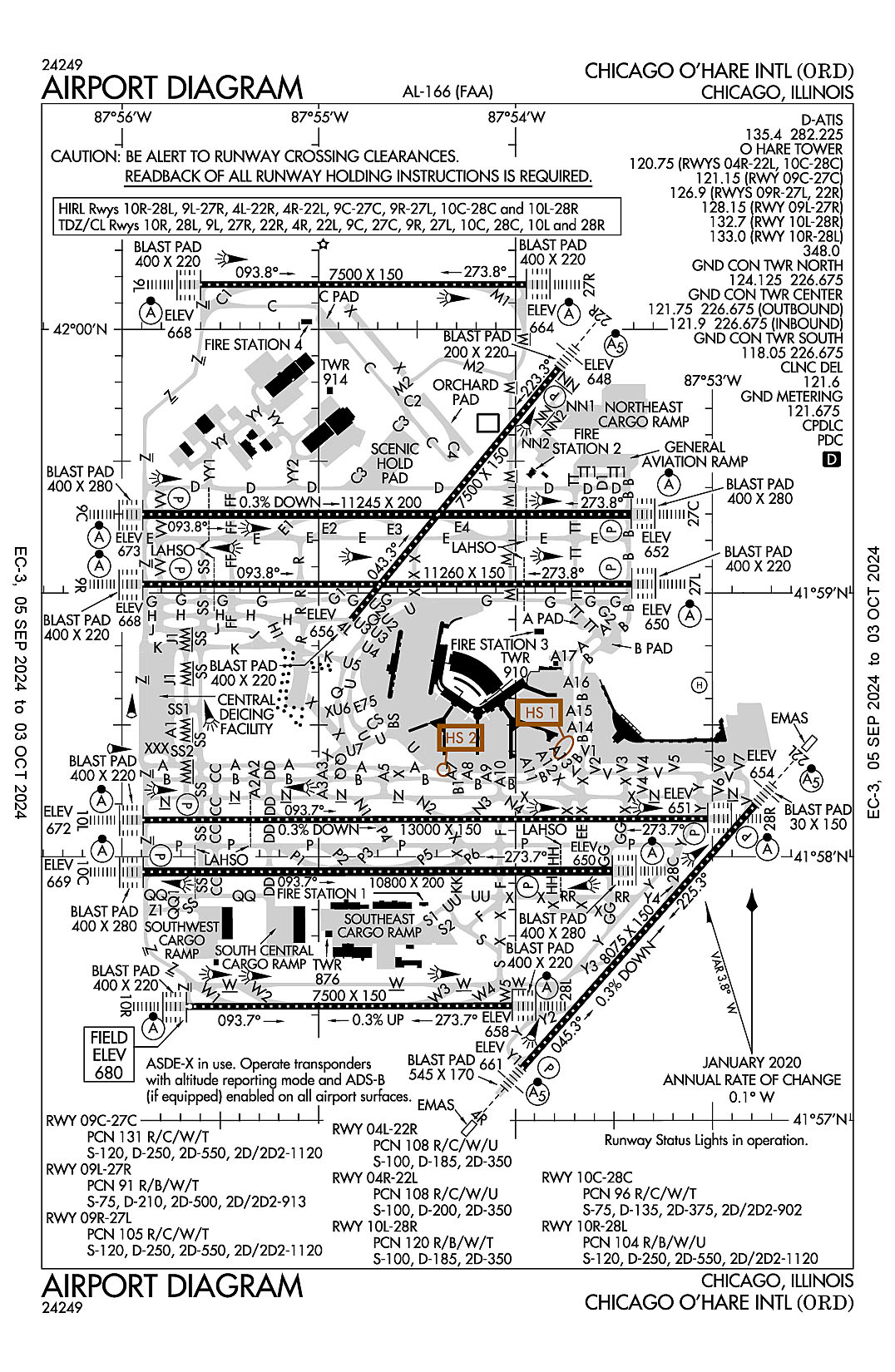
Chicago-O'Hare International
ICAO Identifier KORD
Chicago, IL
Chicago O'Hare Intl
ICAO Identifier KORD
AD 2.2 Aerodrome Geographical and Administrative Data
2.2.1 Reference Point: 41-58-36.985N / 87-54-29.339W
2.2.2 From City: 14 miles NW of CHICAGO, IL
2.2.3 Elevation: 680 ft
2.2.5 Magnetic Variation: 3W (2010)
2.2.6 Airport Contact: JAMIE RHEE
10510 WEST ZEMKE RO
CHICAGO, IL 60666 (773-686-8060)
2.2.7 Traffic: IFR/VFR
AD 2.3 Attendance Schedule
2.3.1 All Months, All Days, All Hours
AD 2.4 Handling Services and Facilities
2.4.1 Cargo Handling Facilities: NO
2.4.2 Fuel Types: 100LL A
2.4.5 Hangar Space:
2.4.6 Repair Facilities: MAJOR
AD 2.6 Rescue and Firefighting Services
2.6.1 Aerodrome Category: Class-I certified on 5/1/1973
2.6.2 Rescue and Firefighting Services: ARFF Index-E
AD 2.12 Runway Physical Characteristics
2.12.1 Designation: 04L
2.12.2 True Bearing: 39
2.12.3 True Dimensions: 7500 ft x 150 ft
2.12.4 PCN: 108 R/C/W/U
2.12.5 Coordinates: 41-58-53.9601N / 87-54-50.1039W
2.12.6 Threshold Elevation: 655.7
2.12.6 Touchdown Zone Elevation: 658.2
2.12.1 Designation: 22R
2.12.2 True Bearing: 219
2.12.3 True Dimensions: 7500 ft x 150 ft
2.12.4 PCN: 108 R/C/W/U
2.12.5 Coordinates: 41-59-51.1336N / 87-53-46.9364W
2.12.6 Threshold Elevation: 647.7
2.12.6 Touchdown Zone Elevation: 651.5
2.12.1 Designation: 22L
2.12.2 True Bearing: 222
2.12.3 True Dimensions: 8075 ft x 150 ft
2.12.4 PCN: 108 R/C/W/U
2.12.5 Coordinates: 41-58-11.718N / 87-52-47.0759W
2.12.6 Threshold Elevation: 654.4
2.12.6 Touchdown Zone Elevation: 654.4
2.12.1 Designation: 04R
2.12.2 True Bearing: 42
2.12.3 True Dimensions: 8075 ft x 150 ft
2.12.4 PCN: 108 R/C/W/U
2.12.5 Coordinates: 41-57-11.9778N / 87-53-57.9066W
2.12.6 Threshold Elevation: 661.4
2.12.6 Touchdown Zone Elevation: 661.4
2.12.1 Designation: 27C
2.12.2 True Bearing: 270
2.12.3 True Dimensions: 11245 ft x 200 ft
2.12.4 PCN: 131 R/C/W/T
2.12.5 Coordinates: 41-59-17.9172N / 87-53-24.7562W
2.12.6 Threshold Elevation: 652.4
2.12.6 Touchdown Zone Elevation: 652.8
2.12.1 Designation: 09C
2.12.2 True Bearing: 90
2.12.3 True Dimensions: 11245 ft x 200 ft
2.12.4 PCN: 131 R/C/W/T
2.12.5 Coordinates: 41-59-17.8916N / 87-55-53.6564W
2.12.6 Threshold Elevation: 673.3
2.12.6 Touchdown Zone Elevation: 673.3
2.12.1 Designation: 09L
2.12.2 True Bearing: 90
2.12.3 True Dimensions: 7500 ft x 150 ft
2.12.4 PCN: 91 R/B/W/T
2.12.5 Coordinates: 42-00-10.1954N / 87-55-36.0339W
2.12.6 Threshold Elevation: 668
2.12.6 Touchdown Zone Elevation: 668
2.12.1 Designation: 27R
2.12.2 True Bearing: 270
2.12.3 True Dimensions: 7500 ft x 150 ft
2.12.4 PCN: 91 R/B/W/T
2.12.5 Coordinates: 42-00-10.1909N / 87-53-56.6997W
2.12.6 Threshold Elevation: 663.6
2.12.6 Touchdown Zone Elevation: 663.6
2.12.1 Designation: 09R
2.12.2 True Bearing: 90
2.12.3 True Dimensions: 11260 ft x 150 ft
2.12.4 PCN: 105 R/C/W/T
2.12.5 Coordinates: 41-59-02.0171N / 87-55-53.6481W
2.12.6 Threshold Elevation: 668.2
2.12.6 Touchdown Zone Elevation: 668.2
2.12.1 Designation: 27L
2.12.2 True Bearing: 270
2.12.3 True Dimensions: 11260 ft x 150 ft
2.12.4 PCN: 105 R/C/W/T
2.12.5 Coordinates: 41-59-02.0417N / 87-53-24.5558W
2.12.6 Threshold Elevation: 650.3
2.12.6 Touchdown Zone Elevation: 653.9
2.12.1 Designation: 28C
2.12.2 True Bearing: 270
2.12.3 True Dimensions: 10800 ft x 200 ft
2.12.4 PCN: 96 R/C/W/T
2.12.5 Coordinates: 41-57-56.7568N / 87-53-30.5171W
2.12.6 Threshold Elevation: 650.1
2.12.6 Touchdown Zone Elevation: 651.1
2.12.1 Designation: 10C
2.12.2 True Bearing: 90
2.12.3 True Dimensions: 10800 ft x 200 ft
2.12.4 PCN: 96 R/C/W/T
2.12.5 Coordinates: 41-57-56.5251N / 87-55-53.4778W
2.12.6 Threshold Elevation: 669.4
2.12.6 Touchdown Zone Elevation: 669.4
2.12.1 Designation: 10L
2.12.2 True Bearing: 90
2.12.3 True Dimensions: 13000 ft x 150 ft
2.12.4 PCN: 120 R/B/W/T
2.12.5 Coordinates: 41-58-08.3816N / 87-55-53.5142W
2.12.6 Threshold Elevation: 672.1
2.12.6 Touchdown Zone Elevation: 672.1
2.12.1 Designation: 28R
2.12.2 True Bearing: 270
2.12.3 True Dimensions: 13000 ft x 150 ft
2.12.4 PCN: 120 R/B/W/T
2.12.5 Coordinates: 41-58-08.6529N / 87-53-01.4244W
2.12.6 Threshold Elevation: 651.4
2.12.6 Touchdown Zone Elevation: 651.4
2.12.1 Designation: 28L
2.12.2 True Bearing: 270
2.12.3 True Dimensions: 7500 ft x 150 ft
2.12.4 PCN: 104 R/B/W/U
2.12.5 Coordinates: 41-57-26.0865N / 87-54-01.0355W
2.12.6 Threshold Elevation: 658
2.12.6 Touchdown Zone Elevation: 666.8
2.12.1 Designation: 10R
2.12.2 True Bearing: 90
2.12.3 True Dimensions: 7500 ft x 150 ft
2.12.4 PCN: 104 R/B/W/U
2.12.5 Coordinates: 41-57-25.924N / 87-55-40.3004W
2.12.6 Threshold Elevation: 680
2.12.6 Touchdown Zone Elevation: 680
2.12.1 Designation: 10X
2.12.2 True Bearing:
2.12.3 True Dimensions: 0 ft x 0 ft
2.12.4 PCN:
2.12.5 Coordinates:
2.12.6 Threshold Elevation:
2.12.6 Touchdown Zone Elevation:
2.12.1 Designation: H1
2.12.2 True Bearing:
2.12.3 True Dimensions: 200 ft x 100 ft
2.12.4 PCN:
2.12.5 Coordinates: 41-58-39.0644N / 87-53-04.0081W
2.12.6 Threshold Elevation: 649.7
2.12.6 Touchdown Zone Elevation:
AD 2.13 Declared Distances
2.13.1 Designation: 04L
2.13.2 Take-off Run Available: 7500
2.13.3 Take-off Distance Available: 7500
2.13.4 Accelerate-Stop Distance Available: 7500
2.13.5 Landing Distance Available:
2.13.1 Designation: 22R
2.13.2 Take-off Run Available:
2.13.3 Take-off Distance Available:
2.13.4 Accelerate-Stop Distance Available:
2.13.5 Landing Distance Available: 7300
2.13.1 Designation: 22L
2.13.2 Take-off Run Available: 8075
2.13.3 Take-off Distance Available: 8075
2.13.4 Accelerate-Stop Distance Available: 8075
2.13.5 Landing Distance Available: 8075
2.13.1 Designation: 04R
2.13.2 Take-off Run Available: 8075
2.13.3 Take-off Distance Available: 8075
2.13.4 Accelerate-Stop Distance Available: 8075
2.13.5 Landing Distance Available: 8075
2.13.1 Designation: 27C
2.13.2 Take-off Run Available: 11245
2.13.3 Take-off Distance Available: 11245
2.13.4 Accelerate-Stop Distance Available: 11245
2.13.5 Landing Distance Available: 11245
2.13.1 Designation: 09C
2.13.2 Take-off Run Available: 11245
2.13.3 Take-off Distance Available: 11245
2.13.4 Accelerate-Stop Distance Available: 11245
2.13.5 Landing Distance Available: 11245
2.13.1 Designation: 09L
2.13.2 Take-off Run Available: 7500
2.13.3 Take-off Distance Available: 7500
2.13.4 Accelerate-Stop Distance Available: 7500
2.13.5 Landing Distance Available: 7500
2.13.1 Designation: 27R
2.13.2 Take-off Run Available: 7500
2.13.3 Take-off Distance Available: 7500
2.13.4 Accelerate-Stop Distance Available: 7500
2.13.5 Landing Distance Available: 7500
2.13.1 Designation: 09R
2.13.2 Take-off Run Available: 11260
2.13.3 Take-off Distance Available: 11260
2.13.4 Accelerate-Stop Distance Available: 11260
2.13.5 Landing Distance Available: 11260
2.13.1 Designation: 27L
2.13.2 Take-off Run Available: 11260
2.13.3 Take-off Distance Available: 11260
2.13.4 Accelerate-Stop Distance Available: 11260
2.13.5 Landing Distance Available: 11260
2.13.1 Designation: 28C
2.13.2 Take-off Run Available: 10800
2.13.3 Take-off Distance Available: 10800
2.13.4 Accelerate-Stop Distance Available: 10800
2.13.5 Landing Distance Available: 10800
2.13.1 Designation: 10C
2.13.2 Take-off Run Available: 10800
2.13.3 Take-off Distance Available: 10800
2.13.4 Accelerate-Stop Distance Available: 10540
2.13.5 Landing Distance Available: 10540
2.13.1 Designation: 10L
2.13.2 Take-off Run Available: 13000
2.13.3 Take-off Distance Available: 13000
2.13.4 Accelerate-Stop Distance Available: 13000
2.13.5 Landing Distance Available: 12246
2.13.1 Designation: 28R
2.13.2 Take-off Run Available: 13000
2.13.3 Take-off Distance Available: 13000
2.13.4 Accelerate-Stop Distance Available: 13000
2.13.5 Landing Distance Available: 13000
2.13.1 Designation: 28L
2.13.2 Take-off Run Available: 7500
2.13.3 Take-off Distance Available: 7500
2.13.4 Accelerate-Stop Distance Available: 7500
2.13.5 Landing Distance Available: 7500
2.13.1 Designation: 10R
2.13.2 Take-off Run Available: 7500
2.13.3 Take-off Distance Available: 7500
2.13.4 Accelerate-Stop Distance Available: 7500
2.13.5 Landing Distance Available: 7500
2.13.1 Designation: 10X
2.13.2 Take-off Run Available:
2.13.3 Take-off Distance Available:
2.13.4 Accelerate-Stop Distance Available:
2.13.5 Landing Distance Available:
2.13.1 Designation: H1
2.13.2 Take-off Run Available:
2.13.3 Take-off Distance Available:
2.13.4 Accelerate-Stop Distance Available:
2.13.5 Landing Distance Available:
AD 2.14 Approach and Runway Lighting
2.14.1 Designation: 04L
2.14.2 Approach Lighting System:
2.14.4 Visual Approach Slope Indicator System:
2.14.1 Designation: 22R
2.14.2 Approach Lighting System: MALSR
2.14.4 Visual Approach Slope Indicator System: P4L
2.14.1 Designation: 22L
2.14.2 Approach Lighting System: MALSR
2.14.4 Visual Approach Slope Indicator System: P4L
2.14.1 Designation: 04R
2.14.2 Approach Lighting System: MALSR
2.14.4 Visual Approach Slope Indicator System: P4R
2.14.1 Designation: 27C
2.14.2 Approach Lighting System: ALSF2
2.14.4 Visual Approach Slope Indicator System: P4L
2.14.1 Designation: 09C
2.14.2 Approach Lighting System: ALSF2
2.14.4 Visual Approach Slope Indicator System: P4L
2.14.1 Designation: 09L
2.14.2 Approach Lighting System: ALSF2
2.14.4 Visual Approach Slope Indicator System:
2.14.1 Designation: 27R
2.14.2 Approach Lighting System: ALSF2
2.14.4 Visual Approach Slope Indicator System:
2.14.1 Designation: 09R
2.14.2 Approach Lighting System: ALSF2
2.14.4 Visual Approach Slope Indicator System: P4L
2.14.1 Designation: 27L
2.14.2 Approach Lighting System: ALSF2
2.14.4 Visual Approach Slope Indicator System: P4R
2.14.1 Designation: 28C
2.14.2 Approach Lighting System: ALSF2
2.14.4 Visual Approach Slope Indicator System: P4L
2.14.1 Designation: 10C
2.14.2 Approach Lighting System: ALSF2
2.14.4 Visual Approach Slope Indicator System: P4L
2.14.1 Designation: 10L
2.14.2 Approach Lighting System: ALSF2
2.14.4 Visual Approach Slope Indicator System: P4L
2.14.1 Designation: 28R
2.14.2 Approach Lighting System: ALSF2
2.14.4 Visual Approach Slope Indicator System: P4L
2.14.1 Designation: 28L
2.14.2 Approach Lighting System: ALSF2
2.14.4 Visual Approach Slope Indicator System:
2.14.1 Designation: 10R
2.14.2 Approach Lighting System: ALSF2
2.14.4 Visual Approach Slope Indicator System:
2.14.1 Designation: 10X
2.14.2 Approach Lighting System:
2.14.4 Visual Approach Slope Indicator System:
2.14.1 Designation: H1
2.14.2 Approach Lighting System:
2.14.4 Visual Approach Slope Indicator System:
AD 2.18 Air Traffic Services Communication Facilities
2.18.1 Service Designation: ALCP
2.18.3 Channel: 252.1
2.18.5 Hours of Operation:
2.18.1 Service Designation: CD PRE TAXI CLNC
2.18.3 Channel: 121.6
2.18.5 Hours of Operation: 24
2.18.1 Service Designation: CD/P
2.18.3 Channel: 121.6
2.18.5 Hours of Operation: 24
2.18.1 Service Designation: CD/S
2.18.3 Channel: 119.25
2.18.5 Hours of Operation: 24
2.18.1 Service Designation: D-ATIS
2.18.3 Channel: 135.4
2.18.5 Hours of Operation: 24
2.18.1 Service Designation: D-ATIS
2.18.3 Channel: 282.225
2.18.5 Hours of Operation: 24
2.18.1 Service Designation: EMERG
2.18.3 Channel: 121.5
2.18.5 Hours of Operation:
2.18.1 Service Designation: EMERG
2.18.3 Channel: 243
2.18.5 Hours of Operation:
2.18.1 Service Designation: GND METERING
2.18.3 Channel: 121.675
2.18.5 Hours of Operation: 24
2.18.1 Service Designation: GND/P (TWR SOUTH)
2.18.3 Channel: 118.05
2.18.5 Hours of Operation: 24
2.18.1 Service Designation: GND/P (TWR CENTER OUTBOUND)
2.18.3 Channel: 121.75
2.18.5 Hours of Operation: 24
2.18.1 Service Designation: GND/P (TWR CENTER INBOUND)
2.18.3 Channel: 121.9
2.18.5 Hours of Operation: 24
2.18.1 Service Designation: GND/P (TWR NORTH)
2.18.3 Channel: 124.125
2.18.5 Hours of Operation: 24
2.18.1 Service Designation: GND/P
2.18.3 Channel: 226.675
2.18.5 Hours of Operation: 24
2.18.1 Service Designation: GND/S (TWR CENTER)
2.18.3 Channel: 134.15
2.18.5 Hours of Operation: 24
2.18.1 Service Designation: LCL/P (RWY 04R/22L)
2.18.3 Channel: 120.75
2.18.5 Hours of Operation: 24
2.18.1 Service Designation: LCL/P (RWY 10C/28C)
2.18.3 Channel: 120.75
2.18.5 Hours of Operation: 24
2.18.1 Service Designation: LCL/P (RWY 09C/27C)
2.18.3 Channel: 121.15
2.18.5 Hours of Operation: 24
2.18.1 Service Designation: LCL/P (RWY 09R/27L)
2.18.3 Channel: 126.9
2.18.5 Hours of Operation: 24
2.18.1 Service Designation: LCL/P (RWY 22R)
2.18.3 Channel: 126.9
2.18.5 Hours of Operation: 24
2.18.1 Service Designation: LCL/P (RWY 09L/27R)
2.18.3 Channel: 128.15
2.18.5 Hours of Operation: 24
2.18.1 Service Designation: LCL/P (RWY 10L/28R)
2.18.3 Channel: 132.7
2.18.5 Hours of Operation: 24
2.18.1 Service Designation: LCL/P (RWY 10R/28L)
2.18.3 Channel: 133
2.18.5 Hours of Operation: 24
2.18.1 Service Designation: LCL/P
2.18.3 Channel: 348
2.18.5 Hours of Operation: 24
2.18.1 Service Designation: PRM (RWY 10C/28C)
2.18.3 Channel: 119.625
2.18.5 Hours of Operation: 24
2.18.1 Service Designation: PRM (RWY 10R/28L)
2.18.3 Channel: 128.05
2.18.5 Hours of Operation: 24
2.18.1 Service Designation: VFR ADZY
2.18.3 Channel: 126.8
2.18.5 Hours of Operation:
AD 2.19 Radio Navigation and Landing Aids
2.19.1 ILS Type: Glide Slop for runway 22R. Magnetic variation: 3W
2.19.2 ILS Identification: RXZ
2.19.5 Coordinates: 41-59-46.5114N / 87-53-59.027W
2.19.6 Site Elevation: 645.1 ft
2.19.1 ILS Type: Localizer for runway 22R. Magnetic variation: 3W
2.19.2 ILS Identification: RXZ
2.19.5 Coordinates: 41-58-47.729N / 87-54-56.987W
2.19.6 Site Elevation: 656.5 ft
2.19.1 ILS Type: Glide Slop for runway 04R. Magnetic variation: 3W
2.19.2 ILS Identification: FJU
2.19.5 Coordinates: 41-57-16.8552N / 87-53-44.3489W
2.19.6 Site Elevation: 654.1 ft
2.19.1 ILS Type: Localizer for runway 04R. Magnetic variation: 3W
2.19.2 ILS Identification: FJU
2.19.5 Coordinates: 41-58-16.1967N / 87-52-41.7631W
2.19.6 Site Elevation: 646.6 ft
2.19.1 ILS Type: Glide Slop for runway 22L. Magnetic variation: 3W
2.19.2 ILS Identification: LQQ
2.19.5 Coordinates: 41-58-00.7989N / 87-52-52.6077W
2.19.6 Site Elevation: 645.9 ft
2.19.1 ILS Type: Localizer for runway 22L. Magnetic variation: 3W
2.19.2 ILS Identification: LQQ
2.19.5 Coordinates: 41-57-05.6133N / 87-54-05.4506W
2.19.6 Site Elevation: 653 ft
2.19.1 ILS Type: DME for runway 09C. Magnetic variation: 3W
2.19.2 ILS Identification: OYG
2.19.5 Coordinates: 41-59-22.1969N / 87-56-07.1574W
2.19.6 Site Elevation: 688.1 ft
2.19.1 ILS Type: Glide Slop for runway 09C. Magnetic variation: 3W
2.19.2 ILS Identification: OYG
2.19.5 Coordinates: 41-59-21.8824N / 87-55-38.9074W
2.19.6 Site Elevation: 667.2 ft
2.19.1 ILS Type: Inner Marker for runway 09C. Magnetic variation: 3W
2.19.2 ILS Identification: OYG
2.19.5 Coordinates: 41-59-17.8812N / 87-56-05.0452W
2.19.6 Site Elevation: 680.4 ft
2.19.1 ILS Type: Localizer for runway 09C. Magnetic variation: 3W
2.19.2 ILS Identification: OYG
2.19.5 Coordinates: 41-59-17.9161N / 87-53-10.9443W
2.19.6 Site Elevation: 656.3 ft
2.19.1 ILS Type: DME for runway 27C. Magnetic variation: 3W
2.19.2 ILS Identification: UYJ
2.19.5 Coordinates: 41-59-22.1969N / 87-56-07.1574W
2.19.6 Site Elevation: 688.1 ft
2.19.1 ILS Type: Glide Slop for runway 27C. Magnetic variation: 3W
2.19.2 ILS Identification: UYJ
2.19.5 Coordinates: 41-59-21.9024N / 87-53-38.9227W
2.19.6 Site Elevation: 646.1 ft
2.19.1 ILS Type: Inner Marker for runway 27C. Magnetic variation: 3W
2.19.2 ILS Identification: UYJ
2.19.5 Coordinates: 41-59-17.9169N / 87-53-13.3671W
2.19.6 Site Elevation: 656.3 ft
2.19.1 ILS Type: Localizer for runway 27C. Magnetic variation: 3W
2.19.2 ILS Identification: UYJ
2.19.5 Coordinates: 41-59-17.8863N / 87-56-07.0691W
2.19.6 Site Elevation: 681.9 ft
2.19.1 ILS Type: DME for runway 09L. Magnetic variation: 3W
2.19.2 ILS Identification: SAJ
2.19.5 Coordinates: 42-00-14.0985N / 87-55-48.2323W
2.19.6 Site Elevation: 669.5 ft
2.19.1 ILS Type: Glide Slop for runway 09L. Magnetic variation: 3W
2.19.2 ILS Identification: SAJ
2.19.5 Coordinates: 42-00-14.2182N / 87-55-20.6714W
2.19.6 Site Elevation: 651.3 ft
2.19.1 ILS Type: Inner Marker for runway 09L. Magnetic variation: 3W
2.19.2 ILS Identification: SAJ
2.19.5 Coordinates: 42-00-10.1934N / 87-55-47.4231W
2.19.6 Site Elevation: 668.8 ft
2.19.1 ILS Type: Localizer for runway 09L. Magnetic variation: 3W
2.19.2 ILS Identification: SAJ
2.19.5 Coordinates: 42-00-10.1874N / 87-53-43.3254W
2.19.6 Site Elevation: 660.9 ft
2.19.1 ILS Type: DME for runway 27R. Magnetic variation: 3W
2.19.2 ILS Identification: ABU
2.19.5 Coordinates: 42-00-14.0985N / 87-55-48.2323W
2.19.6 Site Elevation: 669.5 ft
2.19.1 ILS Type: Glide Slop for runway 27R. Magnetic variation: 3W
2.19.2 ILS Identification: ABU
2.19.5 Coordinates: 42-00-14.2137N / 87-54-11.7412W
2.19.6 Site Elevation: 648.4 ft
2.19.1 ILS Type: Inner Marker for runway 27R. Magnetic variation: 3W
2.19.2 ILS Identification: ABU
2.19.5 Coordinates: 42-00-09.9864N / 87-53-45.3008W
2.19.6 Site Elevation: 663.1 ft
2.19.1 ILS Type: Localizer for runway 27R. Magnetic variation: 3W
2.19.2 ILS Identification: ABU
2.19.5 Coordinates: 42-00-10.1939N / 87-55-50.1994W
2.19.6 Site Elevation: 668.1 ft
2.19.1 ILS Type: DME for runway 09R. Magnetic variation: 3W
2.19.2 ILS Identification: JAV
2.19.5 Coordinates: 41-58-57.74N / 87-53-13.65W
2.19.6 Site Elevation: 673 ft
2.19.1 ILS Type: Glide Slop for runway 09R. Magnetic variation: 3W
2.19.2 ILS Identification: JAV
2.19.5 Coordinates: 41-59-06.96N / 87-55-38.39W
2.19.6 Site Elevation: 661.9 ft
2.19.1 ILS Type: Inner Marker for runway 09R. Magnetic variation: 3W
2.19.2 ILS Identification: JAV
2.19.5 Coordinates: 41-59-02.01N / 87-56-04.01W
2.19.6 Site Elevation: 669.1 ft
2.19.1 ILS Type: Localizer for runway 09R. Magnetic variation: 3W
2.19.2 ILS Identification: JAV
2.19.5 Coordinates: 41-59-02.04N / 87-53-10.79W
2.19.6 Site Elevation: 642 ft
2.19.1 ILS Type: DME for runway 27L. Magnetic variation: 3W
2.19.2 ILS Identification: IAC
2.19.5 Coordinates: 41-58-57.74N / 87-53-13.65W
2.19.6 Site Elevation: 673 ft
2.19.1 ILS Type: Glide Slop for runway 27L. Magnetic variation: 3W
2.19.2 ILS Identification: IAC
2.19.5 Coordinates: 41-59-06.98N / 87-53-38.67W
2.19.6 Site Elevation: 647.3 ft
2.19.1 ILS Type: Inner Marker for runway 27L. Magnetic variation: 3W
2.19.2 ILS Identification: IAC
2.19.5 Coordinates: 41-59-02.04N / 87-53-13.53W
2.19.6 Site Elevation: 645 ft
2.19.1 ILS Type: Localizer for runway 27L. Magnetic variation: 3W
2.19.2 ILS Identification: IAC
2.19.5 Coordinates: 41-59-02.01N / 87-56-07.22W
2.19.6 Site Elevation: 673 ft
2.19.1 ILS Type: DME for runway 10C. Magnetic variation: 3W
2.19.2 ILS Identification: SXH
2.19.5 Coordinates: 41-58-00.9714N / 87-56-09.15W
2.19.6 Site Elevation: 689.3 ft
2.19.1 ILS Type: Glide Slop for runway 10C. Magnetic variation: 3W
2.19.2 ILS Identification: SXH
2.19.5 Coordinates: 41-57-52.8465N / 87-55-39.0226W
2.19.6 Site Elevation: 663 ft
2.19.1 ILS Type: Inner Marker for runway 10C. Magnetic variation: 3W
2.19.2 ILS Identification: SXH
2.19.5 Coordinates: 41-57-56.5015N / 87-56-04.8681W
2.19.6 Site Elevation: 674.3 ft
2.19.1 ILS Type: Localizer for runway 10C. Magnetic variation: 3W
2.19.2 ILS Identification: SXH
2.19.5 Coordinates: 41-57-56.803N / 87-52-57.2925W
2.19.6 Site Elevation: 646.3 ft
2.19.1 ILS Type: DME for runway 28C. Magnetic variation: 3W
2.19.2 ILS Identification: VZE
2.19.5 Coordinates: 41-58-00.9714N / 87-56-09.15W
2.19.6 Site Elevation: 689.3 ft
2.19.1 ILS Type: Glide Slop for runway 28C. Magnetic variation: 3W
2.19.2 ILS Identification: VZE
2.19.5 Coordinates: 41-57-53.0321N / 87-53-44.3196W
2.19.6 Site Elevation: 642.4 ft
2.19.1 ILS Type: Inner Marker for runway 28C. Magnetic variation: 3W
2.19.2 ILS Identification: VZE
2.19.5 Coordinates: 41-57-58.7451N / 87-53-19.1677W
2.19.6 Site Elevation: 648 ft
2.19.1 ILS Type: Localizer for runway 28C. Magnetic variation: 3W
2.19.2 ILS Identification: VZE
2.19.5 Coordinates: 41-57-56.5013N / 87-56-06.8848W
2.19.6 Site Elevation: 676.4 ft
2.19.1 ILS Type: DME for runway 10L. Magnetic variation: 3W
2.19.2 ILS Identification: MED
2.19.5 Coordinates: 41-58-05.6721N / 87-52-41.6845W
2.19.6 Site Elevation: 656 ft
2.19.1 ILS Type: Glide Slop for runway 10L. Magnetic variation: 3W
2.19.2 ILS Identification: MED
2.19.5 Coordinates: 41-58-04.3877N / 87-55-38.7659W
2.19.6 Site Elevation: 665.3 ft
2.19.1 ILS Type: Inner Marker for runway 10L. Magnetic variation: 3W
2.19.2 ILS Identification: MED
2.19.5 Coordinates: 41-58-08.5523N / 87-56-04.8866W
2.19.6 Site Elevation: 676.8 ft
2.19.1 ILS Type: Localizer for runway 10L. Magnetic variation: 3W
2.19.2 ILS Identification: MED
2.19.5 Coordinates: 41-58-08.6818N / 87-52-39.6951W
2.19.6 Site Elevation: 644.9 ft
2.19.1 ILS Type: DME for runway 28R. Magnetic variation: 3W
2.19.2 ILS Identification: TSL
2.19.5 Coordinates: 41-58-05.6721N / 87-52-41.6845W
2.19.6 Site Elevation: 656 ft
2.19.1 ILS Type: Glide Slop for runway 28R. Magnetic variation: 3W
2.19.2 ILS Identification: TSL
2.19.5 Coordinates: 41-58-04.4701N / 87-53-15.0487W
2.19.6 Site Elevation: 648.2 ft
2.19.1 ILS Type: Inner Marker for runway 28R. Magnetic variation: 3W
2.19.2 ILS Identification: TSL
2.19.5 Coordinates: 41-58-06.1128N / 87-52-49.1235W
2.19.6 Site Elevation: 649.5 ft
2.19.1 ILS Type: Localizer for runway 28R. Magnetic variation: 3W
2.19.2 ILS Identification: TSL
2.19.5 Coordinates: 41-58-08.356N / 87-56-06.8801W
2.19.6 Site Elevation: 679.1 ft
2.19.1 ILS Type: DME for runway 10R. Magnetic variation: 4W
2.19.2 ILS Identification: BYW
2.19.5 Coordinates: 41-57-28.3399N / 87-53-27.4609W
2.19.6 Site Elevation: 669.6 ft
2.19.1 ILS Type: Glide Slop for runway 10R. Magnetic variation: 4W
2.19.2 ILS Identification: BYW
2.19.5 Coordinates: 41-57-21.909N / 87-55-25.5702W
2.19.6 Site Elevation: 671.7 ft
2.19.1 ILS Type: Localizer for runway 10R. Magnetic variation: 4W
2.19.2 ILS Identification: BYW
2.19.5 Coordinates: 41-57-31.6045N / 87-53-26.3741W
2.19.6 Site Elevation: 649.9 ft
2.19.1 ILS Type: DME for runway 28L. Magnetic variation: 4W
2.19.2 ILS Identification: VQX
2.19.5 Coordinates: 41-57-22.2251N / 87-53-34.2417W
2.19.6 Site Elevation: 656.1 ft
2.19.1 ILS Type: Glide Slop for runway 28L. Magnetic variation: 4W
2.19.2 ILS Identification: VQX
2.19.5 Coordinates: 41-57-22.0258N / 87-54-14.1801W
2.19.6 Site Elevation: 654 ft
2.19.1 ILS Type: Inner Marker for runway 28L. Magnetic variation: 4W
2.19.2 ILS Identification: VQX
2.19.5 Coordinates: 41-57-26.9517N / 87-53-47.4584W
2.19.6 Site Elevation: 650.4 ft
2.19.1 ILS Type: Localizer for runway 28L. Magnetic variation: 4W
2.19.2 ILS Identification: VQX
2.19.5 Coordinates: 41-57-25.8994N / 87-55-53.7065W
2.19.6 Site Elevation: 680.2 ft
2.19.1 ILS Type: DME for runway 10X. Magnetic variation: 4W
2.19.2 ILS Identification: IZJ
2.19.5 Coordinates: 41-57-22.2251N / 87-53-34.2417W
2.19.6 Site Elevation: 656.1 ft
2.19.1 ILS Type: Glide Slop for runway 10X. Magnetic variation: 4W
2.19.2 ILS Identification: IZJ
2.19.5 Coordinates: 41-57-22.1087N / 87-55-25.5572W
2.19.6 Site Elevation: 671.8 ft
2.19.1 ILS Type: Inner Marker for runway 10X. Magnetic variation: 4W
2.19.2 ILS Identification: IZJ
2.19.5 Coordinates: 41-57-25.9088N / 87-55-51.6695W
2.19.6 Site Elevation: 680 ft
2.19.1 ILS Type: Localizer for runway 10X. Magnetic variation: 4W
2.19.2 ILS Identification: IZJ
2.19.5 Coordinates: 41-57-26.1287N / 87-53-32.5409W
2.19.6 Site Elevation: 652.2 ft
General Remarks:
A380-800 OPR CONSTRAINTS EXIST ON RWYS, TWYS, & RAMPS - CTC ARPT OPS FOR INFO 773-686-2255.
BIRDS ON & INVOF ARPT; PYROTECHNICS & BIRD CANNONS IN USE.
BE ALERT: THE NORTHEAST/SOUTHWEST PORTION OF TWY YY IS NOT VSBL FM THE CENTER ATCT.
RWY STATUS LGTS ARE IN OPN.
MAG DEVIATION PSBL IMT W OF TWY Y & RWY 22L APCH ON TWY N.
EAST AND WEST GATES ARE MANNED 24 HRS A DAY.
ACFT ARE NOT PMTD TO STOP ON EITHER TWY A OR B BRIDGES.
BE ALERT: TWY S1 OBND OR EB ONLY, TWY S2 INBD OR WB ONLY, TWY P1, P2, P3, P5, AND P6 NB ONLY, TWY E1, E2, E3 & E4 SB ONLY. TWY E3 WB ONLY FM RWY 09C/27C.
ALERT: DUPE ALPHA-NUMERIC TWY DESIGNATORS & TRML GATE DESIGNATIONS INVOLVING THE LTRS B, C, G, H, K, L & M.
SEE LND & HOLD SHORT OPS SECTION.
PAEW NEAR VARIOUS TWYS.
ACFT WITH WINGSPAN GREATER THAN 214 FT RQR 48 HRS PPR - 773-686-2255.
LINE UP AND WAIT AUTHORIZATION IN EFF BTWN SS AND SR AT THE FLWG INTS: RWY 28R AT TWY GG, TWY EE AND TWY N5; RWY 10L AT TWY DD AND TWY CC AND TWY SS; RWY 27C AT TWY TT; RWY 9C AT TWY FF; RWY 27L AT TWY TT; RWY 9R AT TWY SS AND FF. THESE RWYS WILL BE USED FOR DEPS ONLY WHEN EXERCISING THE PROVISIONS OF THIS AUTHORIZATION.
ATCT IS AUTH TO CONDUCT SIMUL DEPS FM RWY 04L/04R, RWY 22L/22R, RWY 09R WITH RWY 09L OR RWY 10L, RWY 09C WITH RWY 09L OR RWY 10L, RWY 10C WITH RWY 09R OR RWY 09C, RWY 27L WITH RWY 27R OR RWY 28R, RWY 27C WITH RWY 27R OR RWY 28R, RWY 28C WITH RWY 27L OR RWY 27C WITH CRS DIVERGENCE BEGINNING NO LATER THAN 4 MILES FM RWY END.
B747-8 OPS NOT AUTHORIZED ON RWY 09R/27L, 09L/27R & 10R/28L.
PERIODIC FIRE DEPT TRNG AT N SECTOR OF THE ARPT.
NOISE ABATEMENT PROC IN EFFECT FM 2200 TO 0700; CTC AMGR - 773-686-2255.
TWY NN1 INBD/EB ONLY; TWY NN2 OUBD/WB ONLY.
DVRSN ACRS WO A PRESENCE AT ORD SHOULD CTC ARPT OPNS 773-686-2255 PRIOR TO DIVERTING TO THE EXTENT PRACTICAL AND PRVD: CO, FLIGHT OPS CTC INFO, ACFT TYPE, PERSONS OB, INTL OR DOMESTIC, ANY GND HANDLER AGRMTS IN PLACE.
PRIM RUN-UP LOCATION GROUND RUN UP ENCLOSURE; SECONDARY RUN UP LOCATIONS AVBL UPON REQ - CTC CITY OPS 773-686-2255.
ALL PART 91 & UNSKED PART 125, 133 & 135 CHARTER OPERATORS CTC SIGNATURE FLIGHT SUPPORT AT 773-686-7000 REGARDING NEW SECURITY REGULATIONS PRIOR TO DEP.