Maine
Bangor, Maine
Bangor International
ICAO Identifier KBGR
Bangor, ME
Bangor Intl
ICAO Identifier KBGR
AD 2.2 Aerodrome Geographical and Administrative Data
2.2.1 Reference Point: 44-48-26.8N / 68-49-41.3W
2.2.2 From City: 3 miles W of BANGOR, ME
2.2.3 Elevation: 192.1 ft
2.2.5 Magnetic Variation: 16W (2020)
2.2.6 Airport Contact: JOSE F SAAVEDRA
BANGOR INTERNATIONAL ARPT
BANGOR, ME 4401 (207-992-4600)
2.2.7 Traffic: IFR/VFR
AD 2.3 Attendance Schedule
2.3.1 All Months, All Days, All Hours
AD 2.4 Handling Services and Facilities
2.4.1 Cargo Handling Facilities: YES
2.4.2 Fuel Types: 100LL A
2.4.5 Hangar Space: YES
2.4.6 Repair Facilities: MAJOR
AD 2.6 Rescue and Firefighting Services
2.6.1 Aerodrome Category: Class-I certified on 5/1/1973
2.6.2 Rescue and Firefighting Services: ARFF Index-B
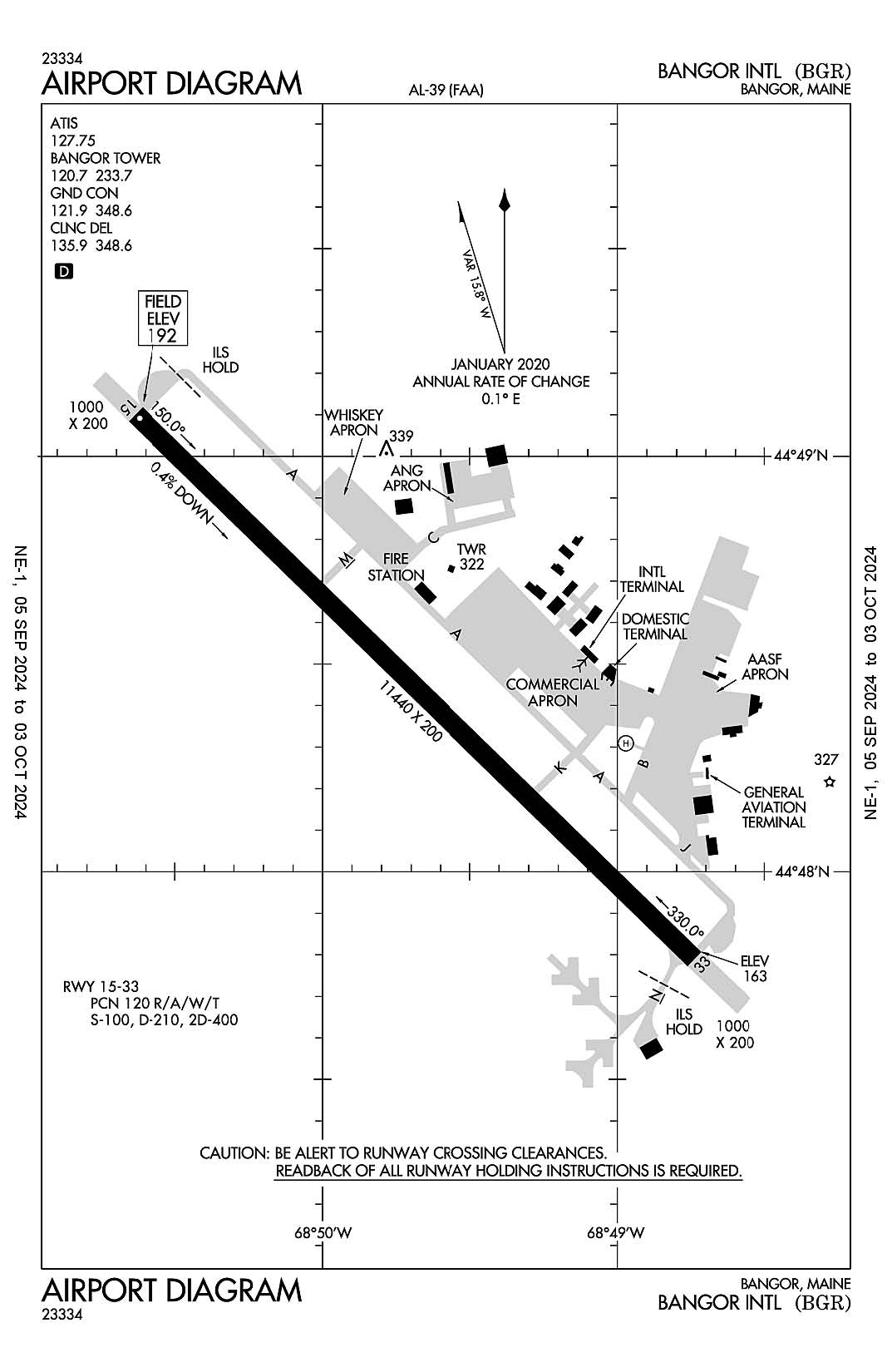
AD 2.12 Runway Physical Characteristics
2.12.1 Designation: 15
2.12.2 True Bearing: 134
2.12.3 True Dimensions: 11440 ft x 200 ft
2.12.4 PCN: 120 R/A/W/T
2.12.5 Coordinates: 44-49-06.1369N / 68-50-38.1522W
2.12.6 Threshold Elevation: 192.1
2.12.6 Touchdown Zone Elevation: 192.1
2.12.1 Designation: 33
2.12.2 True Bearing: 314
2.12.3 True Dimensions: 11440 ft x 200 ft
2.12.4 PCN: 120 R/A/W/T
2.12.5 Coordinates: 44-47-47.4136N / 68-48-44.3618W
2.12.6 Threshold Elevation: 162.9
2.12.6 Touchdown Zone Elevation: 162.9
2.12.1 Designation: H1
2.12.2 True Bearing:
2.12.3 True Dimensions: 100 ft x 100 ft
2.12.4 PCN:
2.12.5 Coordinates: 44-48-18.61N / 68-48-58.78W
2.12.6 Threshold Elevation: 148
2.12.6 Touchdown Zone Elevation:
AD 2.13 Declared Distances
2.13.1 Designation: 15
2.13.2 Take-off Run Available: 11440
2.13.3 Take-off Distance Available: 11440
2.13.4 Accelerate-Stop Distance Available: 11440
2.13.5 Landing Distance Available: 11440
2.13.1 Designation: 33
2.13.2 Take-off Run Available: 11440
2.13.3 Take-off Distance Available: 11440
2.13.4 Accelerate-Stop Distance Available: 11440
2.13.5 Landing Distance Available: 11440
2.13.1 Designation: H1
2.13.2 Take-off Run Available:
2.13.3 Take-off Distance Available:
2.13.4 Accelerate-Stop Distance Available:
2.13.5 Landing Distance Available:
AD 2.14 Approach and Runway Lighting
2.14.1 Designation: 15
2.14.2 Approach Lighting System: ALSF2
2.14.4 Visual Approach Slope Indicator System: P4L
2.14.1 Designation: 33
2.14.2 Approach Lighting System: MALSR
2.14.4 Visual Approach Slope Indicator System: P4L
2.14.1 Designation: H1
2.14.2 Approach Lighting System:
2.14.4 Visual Approach Slope Indicator System:
AD 2.18 Air Traffic Services Communication Facilities
2.18.1 Service Designation: APCH/P DEP/P IC
2.18.3 Channel: 118.925
2.18.5 Hours of Operation: 24
2.18.1 Service Designation: APCH/P DEP/P IC
2.18.3 Channel: 239.3
2.18.5 Hours of Operation: 24
2.18.1 Service Designation: APCH/S DEP/S
2.18.3 Channel: 124.5
2.18.5 Hours of Operation: 24
2.18.1 Service Designation: ATIS
2.18.3 Channel: 127.75
2.18.5 Hours of Operation: 24
2.18.1 Service Designation: CD/P
2.18.3 Channel: 135.9
2.18.5 Hours of Operation: 24
2.18.1 Service Designation: CD/P
2.18.3 Channel: 348.6
2.18.5 Hours of Operation: 24
2.18.1 Service Designation: CLASS C
2.18.3 Channel: 118.925
2.18.5 Hours of Operation: 24
2.18.1 Service Designation: CLASS C
2.18.3 Channel: 239.3
2.18.5 Hours of Operation: 24
2.18.1 Service Designation: CLASS C/S
2.18.3 Channel: 124.5
2.18.5 Hours of Operation: 24
2.18.1 Service Designation: EMERG
2.18.3 Channel: 121.5
2.18.5 Hours of Operation:
2.18.1 Service Designation: EMERG
2.18.3 Channel: 243
2.18.5 Hours of Operation:
2.18.1 Service Designation: GND/P
2.18.3 Channel: 121.9
2.18.5 Hours of Operation: 24
2.18.1 Service Designation: GND/P
2.18.3 Channel: 348.6
2.18.5 Hours of Operation: 24
2.18.1 Service Designation: LCL/P
2.18.3 Channel: 120.7
2.18.5 Hours of Operation: 24
2.18.1 Service Designation: LCL/P
2.18.3 Channel: 233.7
2.18.5 Hours of Operation: 24
2.18.1 Service Designation: NG OPS
2.18.3 Channel: 41.2
2.18.5 Hours of Operation:
AD 2.19 Radio Navigation and Landing Aids
2.19.1 ILS Type: DME for runway 15. Magnetic variation: 16W
2.19.2 ILS Identification: JVH
2.19.5 Coordinates: 44-47-42.4986N / 68-48-31.8082W
2.19.6 Site Elevation: 166.2 ft
2.19.1 ILS Type: Glide Slop for runway 15. Magnetic variation: 16W
2.19.2 ILS Identification: JVH
2.19.5 Coordinates: 44-49-02.1756N / 68-50-22.4761W
2.19.6 Site Elevation: 187.7 ft
2.19.1 ILS Type: Inner Marker for runway 15. Magnetic variation: 16W
2.19.2 ILS Identification: JVH
2.19.5 Coordinates: 44-49-12.0633N / 68-50-46.7197W
2.19.6 Site Elevation: 184 ft
2.19.1 ILS Type: Localizer for runway 15. Magnetic variation: 16W
2.19.2 ILS Identification: JVH
2.19.5 Coordinates: 44-47-40.3704N / 68-48-34.1931W
2.19.6 Site Elevation: 161.7 ft
2.19.1 ILS Type: Middle Marker for runway 15. Magnetic variation: 16W
2.19.2 ILS Identification: JVH
2.19.5 Coordinates: 44-49-23.6858N / 68-51-03.4639W
2.19.6 Site Elevation: 158 ft
2.19.1 ILS Type: DME for runway 33. Magnetic variation: 16W
2.19.2 ILS Identification: BGR
2.19.5 Coordinates: 44-47-42.4986N / 68-48-31.8082W
2.19.6 Site Elevation: 166.2 ft
2.19.1 ILS Type: Glide Slop for runway 33. Magnetic variation: 16W
2.19.2 ILS Identification: BGR
2.19.5 Coordinates: 44-47-53.7039N / 68-48-59.7081W
2.19.6 Site Elevation: 148.8 ft
2.19.1 ILS Type: Localizer for runway 33. Magnetic variation: 16W
2.19.2 ILS Identification: BGR
2.19.5 Coordinates: 44-49-13.6222N / 68-50-48.9786W
2.19.6 Site Elevation: 181.7 ft
2.19.1 Navigation Aid Type VORTAC. Magnetic variation: 19W
2.19.2 Navigation Aid Identification: BGR
2.19.5 Coordinates: 44-50-30.4619N / 68-52-26.2752W
2.19.6 Site Elevation: 360.1 ft
General Remarks:
ANG: PPR VALID +/- 1 HR UNLESS PRIOR CDN. 3 HR OUT CALL, 30 MIN OUT CALL 311.0 TO CFM CSTMS/AG AND TRAN SVC. COMMAND POST C207-404-7788 H24.
FUEL: A++ (MIL).
ANG: CAUTION: BASH PHASE II PERIOD SEP-NOV, APR-MAY. EXPECT INCREASED BIRD ACTIVITY. CONTACT BASE OPS/COMMAND POST/SOF FOR CURRENT BIRDWATCH COND.
ANG: OPR 1100-1930Z++ MON-FRI, CLSD WKEND AND HOL. PPR RQRD FOR ANG RAMP. CTC AFLD MGMT DSN 698-7232, C207-404-7232 FOR PPR DURG OPR HRS. PRE-COORD ALL TRNSPN RQMNTS AND HAZ CARGO WITH PPR REQ.
ARNG: OPR 1230-2100Z++ MON-FRI EXC HOL. LTD MAINT. J8. PPR MAY-OCT SVC DSN 626-1100.
MISC: RWY 15-33 GROOVED.
SVC MIL-FLUID: OFF-BASE CONTRACTED LOX AVBL H24-RQR 24 HR NOTICE.
ANG: TRANSIENT ACFT MAY BE DIVERTED TO CIVILIAN SIDE DURING NON-DUTY HRS & WEEKENDS. FEE REQUIRED; NO ANG TRANSIENT ALERT.
TFC PAT: RWY 33 LEFT TFC, TURBO JET TFC 2000' MSL UNLESS OTHERWISE INSTR.