Utah
Salt Lake City, Utah
Salt Lake City International
ICAO Identifier KSLC
Salt Lake City, UT
Salt Lake City Intl
ICAO Identifier KSLC
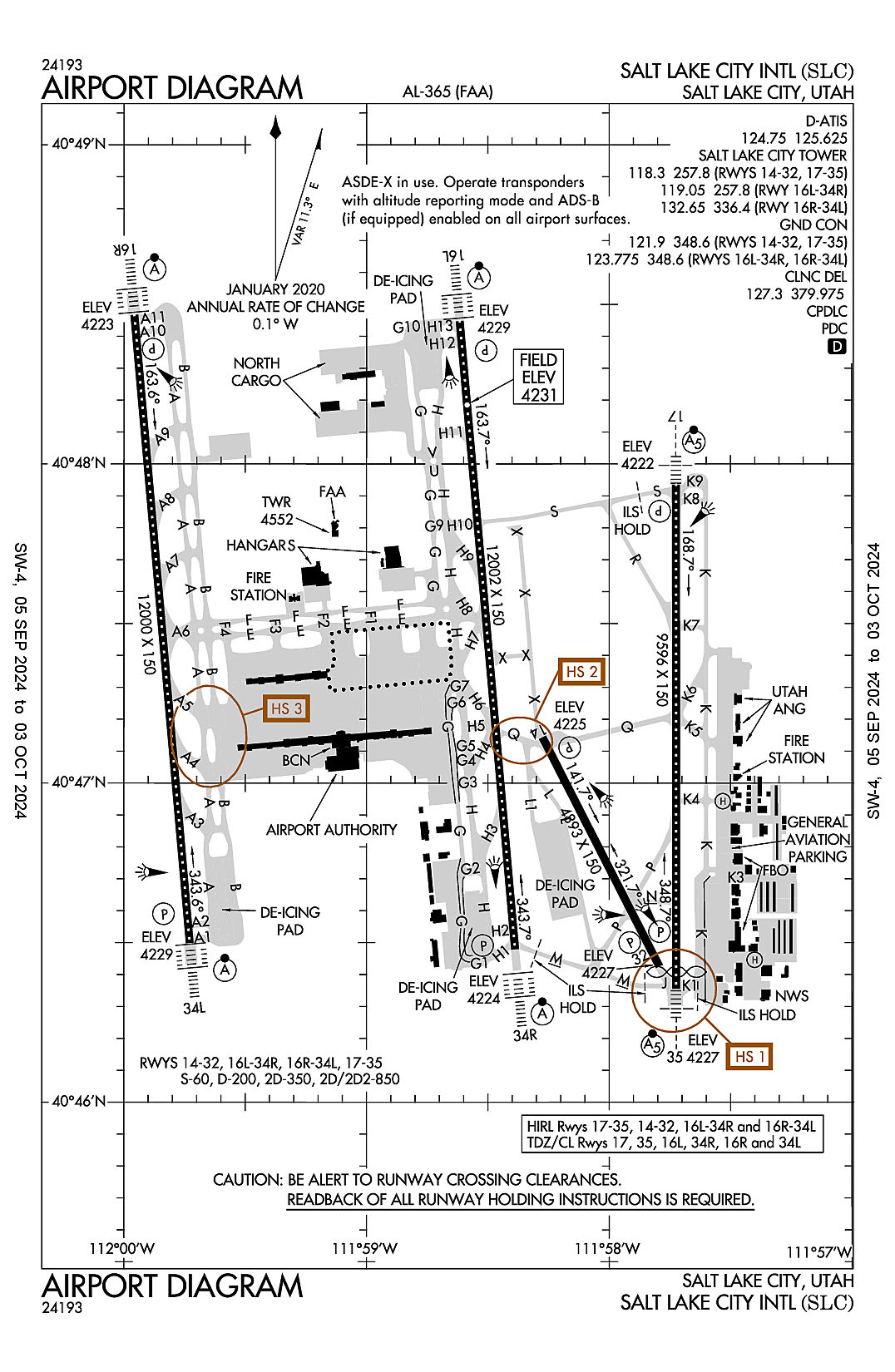
AD 2.2 Aerodrome Geographical and Administrative Data
2.2.1 Reference Point: 40-47-18.216N / 111-58-39.984W
2.2.2 From City: 3 miles W of SALT LAKE CITY, UT
2.2.3 Elevation: 4230.9 ft
2.2.5 Magnetic Variation: 11E (2020)
2.2.6 Airport Contact: MATTHEW BROWN
P.O. BOX 145550
SALT LAKE CITY, UT 84114 (801-575-2244)
2.2.7 Traffic: IFR/VFR
AD 2.3 Attendance Schedule
2.3.1 All Months, All Days, All Hours
AD 2.4 Handling Services and Facilities
2.4.1 Cargo Handling Facilities: YES
2.4.2 Fuel Types: 100LL A1+
2.4.5 Hangar Space: YES
2.4.6 Repair Facilities: MAJOR
AD 2.6 Rescue and Firefighting Services
2.6.1 Aerodrome Category: Class-I certified on 5/1/1973
2.6.2 Rescue and Firefighting Services: ARFF Index-E
AD 2.12 Runway Physical Characteristics
2.12.1 Designation: 14
2.12.2 True Bearing: 153
2.12.3 True Dimensions: 4893 ft x 150 ft
2.12.4 PCN:
2.12.5 Coordinates: 40-47-08.5848N / 111-58-16.4661W
2.12.6 Threshold Elevation: 4224.7
2.12.6 Touchdown Zone Elevation: 4224.8
2.12.1 Designation: 32
2.12.2 True Bearing: 333
2.12.3 True Dimensions: 4893 ft x 150 ft
2.12.4 PCN:
2.12.5 Coordinates: 40-46-25.5192N / 111-57-47.5915W
2.12.6 Threshold Elevation: 4226.8
2.12.6 Touchdown Zone Elevation: 4226.8
2.12.1 Designation: 34R
2.12.2 True Bearing: 355
2.12.3 True Dimensions: 12002 ft x 150 ft
2.12.4 PCN:
2.12.5 Coordinates: 40-46-28.7185N / 111-58-23.2566W
2.12.6 Threshold Elevation: 4224.3
2.12.6 Touchdown Zone Elevation: 4224.7
2.12.1 Designation: 16L
2.12.2 True Bearing: 175
2.12.3 True Dimensions: 12002 ft x 150 ft
2.12.4 PCN:
2.12.5 Coordinates: 40-48-26.8298N / 111-58-36.9557W
2.12.6 Threshold Elevation: 4229.1
2.12.6 Touchdown Zone Elevation: 4230.9
2.12.1 Designation: 16R
2.12.2 True Bearing: 175
2.12.3 True Dimensions: 12000 ft x 150 ft
2.12.4 PCN:
2.12.5 Coordinates: 40-48-28.0035N / 111-59-57.4282W
2.12.6 Threshold Elevation: 4223.4
2.12.6 Touchdown Zone Elevation: 4225.8
2.12.1 Designation: 34L
2.12.2 True Bearing: 355
2.12.3 True Dimensions: 12000 ft x 150 ft
2.12.4 PCN:
2.12.5 Coordinates: 40-46-29.9171N / 111-59-43.6913W
2.12.6 Threshold Elevation: 4228.8
2.12.6 Touchdown Zone Elevation: 4228.8
2.12.1 Designation: 35
2.12.2 True Bearing: 360
2.12.3 True Dimensions: 9596 ft x 150 ft
2.12.4 PCN:
2.12.5 Coordinates: 40-46-21.3022N / 111-57-43.4496W
2.12.6 Threshold Elevation: 4226.8
2.12.6 Touchdown Zone Elevation: 4226.9
2.12.1 Designation: 17
2.12.2 True Bearing: 180
2.12.3 True Dimensions: 9596 ft x 150 ft
2.12.4 PCN:
2.12.5 Coordinates: 40-47-56.1043N / 111-57-43.4552W
2.12.6 Threshold Elevation: 4221.7
2.12.6 Touchdown Zone Elevation: 4222.2
2.12.1 Designation: HB
2.12.2 True Bearing:
2.12.3 True Dimensions: 60 ft x 60 ft
2.12.4 PCN:
2.12.5 Coordinates: 40-46-27.0827N / 111-57-24.0562W
2.12.6 Threshold Elevation: 4220.4
2.12.6 Touchdown Zone Elevation:
2.12.1 Designation: HF
2.12.2 True Bearing:
2.12.3 True Dimensions: 60 ft x 60 ft
2.12.4 PCN:
2.12.5 Coordinates: 40-46-56.68N / 111-57-33.81W
2.12.6 Threshold Elevation: 4220
2.12.6 Touchdown Zone Elevation:
AD 2.13 Declared Distances
2.13.1 Designation: 14
2.13.2 Take-off Run Available: 4893
2.13.3 Take-off Distance Available: 4893
2.13.4 Accelerate-Stop Distance Available: 4893
2.13.5 Landing Distance Available: 4893
2.13.1 Designation: 32
2.13.2 Take-off Run Available: 4893
2.13.3 Take-off Distance Available: 4893
2.13.4 Accelerate-Stop Distance Available: 4893
2.13.5 Landing Distance Available: 4893
2.13.1 Designation: 34R
2.13.2 Take-off Run Available: 12002
2.13.3 Take-off Distance Available: 12002
2.13.4 Accelerate-Stop Distance Available: 12002
2.13.5 Landing Distance Available: 12002
2.13.1 Designation: 16L
2.13.2 Take-off Run Available: 12002
2.13.3 Take-off Distance Available: 12002
2.13.4 Accelerate-Stop Distance Available: 12002
2.13.5 Landing Distance Available: 12002
2.13.1 Designation: 16R
2.13.2 Take-off Run Available: 12000
2.13.3 Take-off Distance Available: 12000
2.13.4 Accelerate-Stop Distance Available: 12000
2.13.5 Landing Distance Available: 12000
2.13.1 Designation: 34L
2.13.2 Take-off Run Available: 12000
2.13.3 Take-off Distance Available: 12000
2.13.4 Accelerate-Stop Distance Available: 12000
2.13.5 Landing Distance Available: 12000
2.13.1 Designation: 35
2.13.2 Take-off Run Available: 9596
2.13.3 Take-off Distance Available: 9596
2.13.4 Accelerate-Stop Distance Available: 9596
2.13.5 Landing Distance Available: 9272
2.13.1 Designation: 17
2.13.2 Take-off Run Available: 9596
2.13.3 Take-off Distance Available: 9596
2.13.4 Accelerate-Stop Distance Available: 9596
2.13.5 Landing Distance Available: 9596
2.13.1 Designation: HB
2.13.2 Take-off Run Available:
2.13.3 Take-off Distance Available:
2.13.4 Accelerate-Stop Distance Available:
2.13.5 Landing Distance Available:
2.13.1 Designation: HF
2.13.2 Take-off Run Available:
2.13.3 Take-off Distance Available:
2.13.4 Accelerate-Stop Distance Available:
2.13.5 Landing Distance Available:
AD 2.14 Approach and Runway Lighting
2.14.1 Designation: 14
2.14.2 Approach Lighting System:
2.14.4 Visual Approach Slope Indicator System: P4L
2.14.1 Designation: 32
2.14.2 Approach Lighting System:
2.14.4 Visual Approach Slope Indicator System: P4L
2.14.1 Designation: 34R
2.14.2 Approach Lighting System: ALSF2
2.14.4 Visual Approach Slope Indicator System: P4L
2.14.1 Designation: 16L
2.14.2 Approach Lighting System: ALSF2
2.14.4 Visual Approach Slope Indicator System: P4L
2.14.1 Designation: 16R
2.14.2 Approach Lighting System: ALSF2
2.14.4 Visual Approach Slope Indicator System: P4L
2.14.1 Designation: 34L
2.14.2 Approach Lighting System: ALSF2
2.14.4 Visual Approach Slope Indicator System: P4L
2.14.1 Designation: 35
2.14.2 Approach Lighting System: MALSR
2.14.4 Visual Approach Slope Indicator System: P4L
2.14.1 Designation: 17
2.14.2 Approach Lighting System: MALSR
2.14.4 Visual Approach Slope Indicator System: P4R
2.14.1 Designation: HB
2.14.2 Approach Lighting System:
2.14.4 Visual Approach Slope Indicator System:
2.14.1 Designation: HF
2.14.2 Approach Lighting System:
2.14.4 Visual Approach Slope Indicator System:
AD 2.18 Air Traffic Services Communication Facilities
2.18.1 Service Designation: ANG COMD POST
2.18.3 Channel: 303.15
2.18.5 Hours of Operation:
2.18.1 Service Designation: ANG COMD POST
2.18.3 Channel: 311
2.18.5 Hours of Operation:
2.18.1 Service Designation: CD PRE DEP CLNC
2.18.3 Channel: 127.3
2.18.5 Hours of Operation:
2.18.1 Service Designation: CD PRE TAXI CLNC
2.18.3 Channel: 127.3
2.18.5 Hours of Operation: 24
2.18.1 Service Designation: CD/P
2.18.3 Channel: 379.975
2.18.5 Hours of Operation: 24
2.18.1 Service Designation: D-ATIS
2.18.3 Channel: 124.75
2.18.5 Hours of Operation: 24
2.18.1 Service Designation: D-ATIS
2.18.3 Channel: 125.625
2.18.5 Hours of Operation: 24
2.18.1 Service Designation: EMERG
2.18.3 Channel: 121.5
2.18.5 Hours of Operation:
2.18.1 Service Designation: EMERG
2.18.3 Channel: 243
2.18.5 Hours of Operation:
2.18.1 Service Designation: GND/P (RWY 14/32, 17/35)
2.18.3 Channel: 121.9
2.18.5 Hours of Operation: 24
2.18.1 Service Designation: GND/P (RWY 16L/34R, 16R/34L)
2.18.3 Channel: 123.775
2.18.5 Hours of Operation: 24
2.18.1 Service Designation: GND/P
2.18.3 Channel: 348.6
2.18.5 Hours of Operation: 24
2.18.1 Service Designation: LCL/P (RWY 14/32, 17/35)
2.18.3 Channel: 118.3
2.18.5 Hours of Operation: 24
2.18.1 Service Designation: LCL/P (RWY 16L/34R)
2.18.3 Channel: 119.05
2.18.5 Hours of Operation: 24
2.18.1 Service Designation: LCL/P (RWY 16R/34L)
2.18.3 Channel: 132.65
2.18.5 Hours of Operation: 24
2.18.1 Service Designation: LCL/P (RWY 14/32, 16L/34R, 17/35)
2.18.3 Channel: 257.8
2.18.5 Hours of Operation: 24
2.18.1 Service Designation: LCL/P (RWY 16R/34L)
2.18.3 Channel: 336.4
2.18.5 Hours of Operation: 24
AD 2.19 Radio Navigation and Landing Aids
2.19.1 ILS Type: DME for runway 16L. Magnetic variation: 11E
2.19.2 ILS Identification: MOY
2.19.5 Coordinates: 40-46-18.724N / 111-58-18.1254W
2.19.6 Site Elevation: 4239.9 ft
2.19.1 ILS Type: Glide Slop for runway 16L. Magnetic variation: 11E
2.19.2 ILS Identification: MOY
2.19.5 Coordinates: 40-48-17.0756N / 111-58-30.6172W
2.19.6 Site Elevation: 4225 ft
2.19.1 ILS Type: Inner Marker for runway 16L. Magnetic variation: 11E
2.19.2 ILS Identification: MOY
2.19.5 Coordinates: 40-48-35.7038N / 111-58-38.0115W
2.19.6 Site Elevation: 4222.8 ft
2.19.1 ILS Type: Localizer for runway 16L. Magnetic variation: 11E
2.19.2 ILS Identification: MOY
2.19.5 Coordinates: 40-46-18.5061N / 111-58-22.0717W
2.19.6 Site Elevation: 4226.5 ft
2.19.1 ILS Type: DME for runway 34R. Magnetic variation: 11E
2.19.2 ILS Identification: SLC
2.19.5 Coordinates: 40-46-18.724N / 111-58-18.1254W
2.19.6 Site Elevation: 4239.9 ft
2.19.1 ILS Type: Glide Slop for runway 34R. Magnetic variation: 11E
2.19.2 ILS Identification: SLC
2.19.5 Coordinates: 40-46-39.3436N / 111-58-19.2908W
2.19.6 Site Elevation: 4220 ft
2.19.1 ILS Type: Inner Marker for runway 34R. Magnetic variation: 11E
2.19.2 ILS Identification: SLC
2.19.5 Coordinates: 40-46-20.3855N / 111-58-22.2947W
2.19.6 Site Elevation: 4225.1 ft
2.19.1 ILS Type: Localizer for runway 34R. Magnetic variation: 11E
2.19.2 ILS Identification: SLC
2.19.5 Coordinates: 40-48-37.6811N / 111-58-38.2145W
2.19.6 Site Elevation: 4224.5 ft
2.19.1 ILS Type: DME for runway 16R. Magnetic variation: 11E
2.19.2 ILS Identification: UAT
2.19.5 Coordinates: 40-46-19.627N / 111-59-46.3581W
2.19.6 Site Elevation: 4233.6 ft
2.19.1 ILS Type: Glide Slop for runway 16R. Magnetic variation: 11E
2.19.2 ILS Identification: UAT
2.19.5 Coordinates: 40-48-17.3028N / 112-00-01.6005W
2.19.6 Site Elevation: 4218.7 ft
2.19.1 ILS Type: Localizer for runway 16R. Magnetic variation: 11E
2.19.2 ILS Identification: UAT
2.19.5 Coordinates: 40-46-19.9476N / 111-59-42.5324W
2.19.6 Site Elevation: 4227.2 ft
2.19.1 ILS Type: DME for runway 34L. Magnetic variation: 11E
2.19.2 ILS Identification: UUH
2.19.5 Coordinates: 40-46-19.627N / 111-59-46.3581W
2.19.6 Site Elevation: 4233.6 ft
2.19.1 ILS Type: Glide Slop for runway 34L. Magnetic variation: 11E
2.19.2 ILS Identification: UUH
2.19.5 Coordinates: 40-46-39.8998N / 111-59-50.2673W
2.19.6 Site Elevation: 4222.6 ft
2.19.1 ILS Type: Localizer for runway 34L. Magnetic variation: 11E
2.19.2 ILS Identification: UUH
2.19.5 Coordinates: 40-48-37.9731N / 111-59-58.5893W
2.19.6 Site Elevation: 4220 ft
2.19.1 ILS Type: DME for runway 17. Magnetic variation: 11E
2.19.2 ILS Identification: BNT
2.19.5 Coordinates: 40-46-09.7838N / 111-57-47.5356W
2.19.6 Site Elevation: 4242.7 ft
2.19.1 ILS Type: Glide Slop for runway 17. Magnetic variation: 11E
2.19.2 ILS Identification: BNT
2.19.5 Coordinates: 40-47-45.7497N / 111-57-50.0372W
2.19.6 Site Elevation: 4216.4 ft
2.19.1 ILS Type: Localizer for runway 17. Magnetic variation: 11E
2.19.2 ILS Identification: BNT
2.19.5 Coordinates: 40-46-10.0541N / 111-57-43.4502W
2.19.6 Site Elevation: 4227.9 ft
2.19.1 ILS Type: DME for runway 35. Magnetic variation: 11E
2.19.2 ILS Identification: UTJ
2.19.5 Coordinates: 40-46-09.7838N / 111-57-47.5356W
2.19.6 Site Elevation: 4242.7 ft
2.19.1 ILS Type: Glide Slop for runway 35. Magnetic variation: 11E
2.19.2 ILS Identification: UTJ
2.19.5 Coordinates: 40-46-35.1583N / 111-57-48.6413W
2.19.6 Site Elevation: 4229.2 ft
2.19.1 ILS Type: Localizer for runway 35. Magnetic variation: 11E
2.19.2 ILS Identification: UTJ
2.19.5 Coordinates: 40-47-08.3329N / 111-57-51.5557W
2.19.6 Site Elevation: 4220.8 ft
General Remarks:
SEE CURRENT NOTAMS FOR DATES AND ADDITIONAL INFO.
MILITARY: ANG RAMP: NSTD PAVEMENT MARK ON RAMP.
SVFR IS NOT RCMD AT THE ARPT, IF REQD, EXPT DLAS.
TWY Y RSTD TO WINGSPANS LESS THAN 171 FT BTWN TWY H3 AND H4.
MILITARY: ANG RAMP: OPR 1430-2230Z++ MON-THU. CLSD FRI-SUN AND HOL. OFFL BUS ONLY. PPR REQ 48 HR ALL ACFT, VALID 1 HR +/- ETA. TRAN PRK/SVC EXTREMELY LTD. BASE OPS DSN 245-2274, C801-245-2274. MIL ALT HILL AFB (KHIF) 25 NM N. ALL ACFT CTC UTAH CTL (COMD POST) 20 MIN OUT WITH ETA AND REQ.
SURFACE MOVEMENT GUIDANCE CONTROL SYSTEM & LOW VISIBILITY TAXI PROCEDURES.
HELIPADS B AND F LOCATED ON GENERAL AVIATION APRONS.
USE CAUTION FOR EXTENSIVE PARAGLIDING OPS INVOF POINT OF THE MOUNTAIN.
SEE FLIP AP/1 SUPPLEMENTARY ARPT INFO.
MILITARY: COMMUNICATIONS: ANG COMD POST - CALL UTAH CONTROL.
USE MINIMUM THRUST IN CONSTRUCTION AREAS.
CONTACT GROUND ON 123.775 BEFORE TAXIING OUT OF NORTH CARGO.
DUE TO TFC VOL, LCL DEPARTURE AND ARR OPNS ARE DISCOURAGED AND DLAS CAN BE EXPCD BTN 1500-1730Z++ AND 0130-0300Z++.
MILITARY: SVC: FUEL A++.
TWY K RSTRD TO ACFT WITH WINGSPAN LESS THAN 171 FT.
FLOCK OF BIRDS ON AND IN VICINITY OF ARPT.
MILITARY: ANG RAMP: ALL ACFT CTC UTAH CONTROL WITH LDG & DEP TIMES. COMD POST DSN: 245-2416/2417; C801-245-2416/2417. PHASE II WILDLIFE ACT DURING MIGRATION/MORNING/EVENING HRS FR OCT-APR. CTC UTAH CTL FOR CURRENT BIRD-WATCH COND.