Washington
Everett, Washington
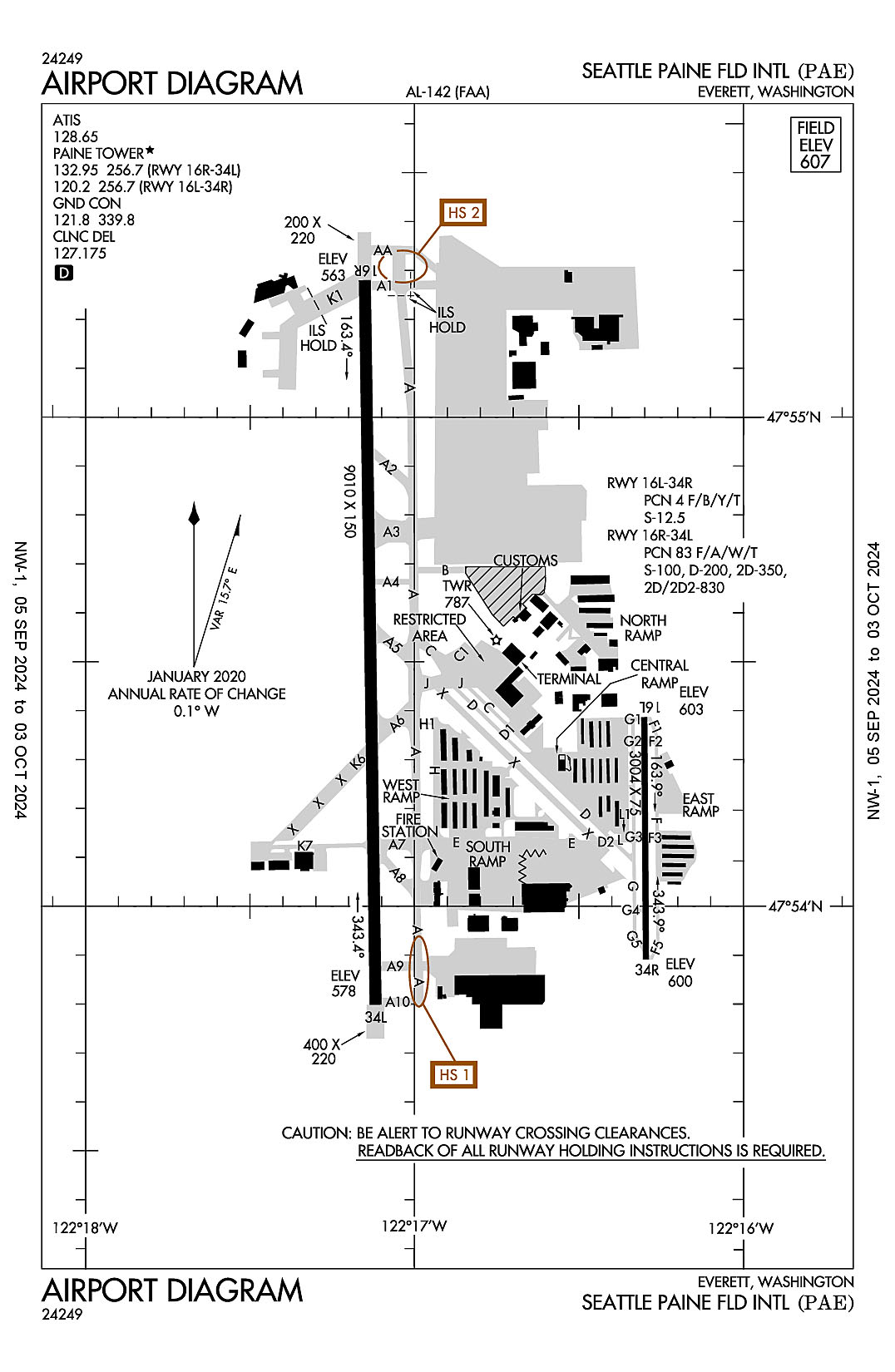
Snohomish County (Paine Field)
ICAO Identifier KPAE
Everett, WA
Snohomish County (Paine Fld)
ICAO Identifier KPAE
AD 2.2 Aerodrome Geographical and Administrative Data
2.2.1 Reference Point: 47-54-26.345N / 122-16-55.538W
2.2.2 From City: 6 miles SW of EVERETT, WA
2.2.3 Elevation: 606.9 ft
2.2.5 Magnetic Variation: 16E (2020)
2.2.6 Airport Contact: JOSHUA MARCY
3220 100TH ST SW
EVERETT, WA 98204 (425-308-2347)
2.2.7 Traffic: IFR/VFR
AD 2.3 Attendance Schedule
2.3.1 MAY-OCT Months, All Days, 0700-2100 Hours
AD 2.4 Handling Services and Facilities
2.4.1 Cargo Handling Facilities: NO
2.4.2 Fuel Types: 100LL A
2.4.5 Hangar Space: YES
2.4.6 Repair Facilities: MAJOR
AD 2.6 Rescue and Firefighting Services
2.6.1 Aerodrome Category: Class-I certified on 11/1/1974
2.6.2 Rescue and Firefighting Services: ARFF Index-B
AD 2.12 Runway Physical Characteristics
2.12.1 Designation: 16L
2.12.2 True Bearing: 180
2.12.3 True Dimensions: 3004 ft x 75 ft
2.12.4 PCN: 4 F/B/Y/T
2.12.5 Coordinates: 47-54-23.129N / 122-16-18.0936W
2.12.6 Threshold Elevation: 602.9
2.12.6 Touchdown Zone Elevation: 606.9
2.12.1 Designation: 34R
2.12.2 True Bearing: 360
2.12.3 True Dimensions: 3004 ft x 75 ft
2.12.4 PCN: 4 F/B/Y/T
2.12.5 Coordinates: 47-53-53.4898N / 122-16-17.7647W
2.12.6 Threshold Elevation: 599.8
2.12.6 Touchdown Zone Elevation: 606.9
2.12.1 Designation: 16R
2.12.2 True Bearing: 179
2.12.3 True Dimensions: 9010 ft x 150 ft
2.12.4 PCN: 83 F/A/W/T
2.12.5 Coordinates: 47-55-16.8088N / 122-17-09.0632W
2.12.6 Threshold Elevation: 562.7
2.12.6 Touchdown Zone Elevation: 569.8
2.12.1 Designation: 34L
2.12.2 True Bearing: 359
2.12.3 True Dimensions: 9010 ft x 150 ft
2.12.4 PCN: 83 F/A/W/T
2.12.5 Coordinates: 47-53-47.904N / 122-17-07.0916W
2.12.6 Threshold Elevation: 577.6
2.12.6 Touchdown Zone Elevation: 583.4
AD 2.13 Declared Distances
2.13.1 Designation: 16L
2.13.2 Take-off Run Available: 3004
2.13.3 Take-off Distance Available: 3004
2.13.4 Accelerate-Stop Distance Available: 3004
2.13.5 Landing Distance Available: 3004
2.13.1 Designation: 34R
2.13.2 Take-off Run Available: 3004
2.13.3 Take-off Distance Available: 3004
2.13.4 Accelerate-Stop Distance Available: 3004
2.13.5 Landing Distance Available: 3004
2.13.1 Designation: 16R
2.13.2 Take-off Run Available: 9010
2.13.3 Take-off Distance Available: 9010
2.13.4 Accelerate-Stop Distance Available: 9010
2.13.5 Landing Distance Available: 9010
2.13.1 Designation: 34L
2.13.2 Take-off Run Available: 9010
2.13.3 Take-off Distance Available: 9010
2.13.4 Accelerate-Stop Distance Available: 9010
2.13.5 Landing Distance Available: 9010
AD 2.14 Approach and Runway Lighting
2.14.1 Designation: 16L
2.14.2 Approach Lighting System:
2.14.4 Visual Approach Slope Indicator System: P2L
2.14.1 Designation: 34R
2.14.2 Approach Lighting System:
2.14.4 Visual Approach Slope Indicator System: P2L
2.14.1 Designation: 16R
2.14.2 Approach Lighting System: MALSR
2.14.4 Visual Approach Slope Indicator System: P4R
2.14.1 Designation: 34L
2.14.2 Approach Lighting System: MALSF
2.14.4 Visual Approach Slope Indicator System: P4L
AD 2.18 Air Traffic Services Communication Facilities
2.18.1 Service Designation: AR OPS
2.18.3 Channel: 34.1
2.18.5 Hours of Operation:
2.18.1 Service Designation: ATIS
2.18.3 Channel: 128.65
2.18.5 Hours of Operation: 24
2.18.1 Service Designation: CD/P
2.18.3 Channel: 127.175
2.18.5 Hours of Operation: 0700-2100
2.18.1 Service Designation: GND/P
2.18.3 Channel: 121.8
2.18.5 Hours of Operation: 0700-2100
2.18.1 Service Designation: GND/P
2.18.3 Channel: 339.8
2.18.5 Hours of Operation: 0700-2100
2.18.1 Service Designation: LCL/P (RWY 16L/34R)
2.18.3 Channel: 120.2
2.18.5 Hours of Operation: 0700-2100
2.18.1 Service Designation: LCL/P
2.18.3 Channel: 256.7
2.18.5 Hours of Operation: 0700-2100
2.18.1 Service Designation: LCL/P IC (RWY 16R/34L)
2.18.3 Channel: 132.95
2.18.5 Hours of Operation: 0700-2100
AD 2.19 Radio Navigation and Landing Aids
2.19.1 ILS Type: Glide Slop for runway 16R. Magnetic variation: 16E
2.19.2 ILS Identification: PAE
2.19.5 Coordinates: 47-55-07.3456N / 122-17-13.6246W
2.19.6 Site Elevation: 566.4 ft
2.19.1 ILS Type: Localizer for runway 16R. Magnetic variation: 16E
2.19.2 ILS Identification: PAE
2.19.5 Coordinates: 47-53-34.031N / 122-17-06.7829W
2.19.6 Site Elevation: 569.7 ft
2.19.1 Navigation Aid Type VOR/DME. Magnetic variation: 20E
2.19.2 Navigation Aid Identification: PAE
2.19.5 Coordinates: 47-55-11.3996N / 122-16-40.0864W
2.19.6 Site Elevation: 669.2 ft
General Remarks:
IT IS REQ THAT PILOTS ADHERE TO THE FLW NOISE ABATEMENT PROC UNLESS OTRW INSTRD BY ATCT, ITNRNT ARR AND LOW APCH OF SML ACFT OVER 250 HORSEPOWER AUZ ON RWYS 16L AND 34R.
NOISE SENSITIVE ARPT; FOR NOISE ABATEMENT PROC & TFC PROC CALL ARPT OPS 425-388-5125.
AIRFIELD CONDS NOT MNTD BTN 0000-0600.
TSNT HEL EXP LNDG/TKOF ON TWY B.
ITNRNT DEP OF SML ACFT OVER 250 HORSEPOWER ON RWY 34R.
TRNG FLTS DISCOURAGED AFT 2200.
FOR NOISE ABATEMENT FROM 0500-1500Z++ IF ACFT PERFORMANCE/WIND ALLOWS, USE RY 16R FOR ARRIVALS AND RY 34L FOR DEPARTURES.
TWY C BTN TRML RAMP AND CNTRL RAMP RSTRD TO WINGSPAN OF 68 FT OR LESS. TWY D, F, G AND L RSTRD TO WINGSPAN LESS THAN 49 FT. TWY A4, A5, K7 & B RSTRD TO WINGSPAN LESS THAN 118 FT. TAXILANE H RSTRD TO WINGSPAN LESS THAN 49 FT.
LRG ACFT FLY W PAT OVR WTR; SML ACFT FLY E PAT OVR ARPT.
AVOID LOW LVL OVRFLT OF BOEING RAMP; NE CORNER OF ARPT DUE TO JET BLAST.
FLOCKS OF LRG & SML BIRDS INVOF ARPT.
BE ALERT TO CNVG TFC ON BASE TO FINAL LEGS RWY 16R/34L 2100-0700.
FOR CD WHEN ATCT IS CLSD CTC SEATTLE APCH AT 206-214-4722.
PAE HAS FAC CONSTRAINTS THAT LMT ITS ABILITY TO ACCOMMODATE DIVD FLTS AND MNTN THE ARPTS SAFE OPN DUR IREG OPS. ACFT OPR SHOULD CTCT THE ON-DUTY ARPT OPS PSNL (425-388-5125) TO COORD DIVD FLTS EXC IN THE CASE OF A DECLARED IN-FLT EMERG.
PPR RQRD FOR ACES ON BOEING RAMP. CTC BOEING FLT DISPATCH 206-544-5900 FOR APVL. PRIOR TO TAXI ONTO BOEING RAMP CTC BOEING RADIO TWR 123.475 OR CALL 425-342-5900.
TWY K1 CLSD TO ACFT UNDER 30000 LBS.
TKOF CLNC RWY 16R FULL LEN; ENT RWY VIA TWY A1 UNLESS TWY AA SPECIFIED.
USE CTN FOR 80 FT AGL LGT POLES SW EDGE OF BRAVO RAMP.
TWY A-2 RSTRD TO 30000 LBS.
EMERG FREQ 121.5 NOT MNT AT TWR. SEATTLE APP CON-TRACON MNT 121.5 FOR EVERETT (PAE).
AREAS NOT VSB FM ATCT INCL E EDGE OF S 1200 FT OF TWY A, TAXILANE E FM SE CORNER OF W HNGRS TO TWY A, TAXILANE H FROM NW EDGE OF W HNGRS TO TAXILANE E.
TAXILANE E RSTD TO WINGSPAN LESS THAN 171 FT. ACFT WINGSPAN OF 171 FT OR GREATER ON TAXILANE E, TUG OPS ONLY. EAST 500 FT OF TAXILANE E RSTD TO WINGSPAN LESS THAN 49 FT.
Seattle, Washington
Seattle-Tacoma International
ICAO Identifier KSEA
Seattle, WA
Seattle-Tacoma Intl
ICAO Identifier KSEA
AD 2.2 Aerodrome Geographical and Administrative Data
2.2.1 Reference Point: 47-26-59.6N / 122-18-42.4W
2.2.2 From City: 10 miles S of SEATTLE, WA
2.2.3 Elevation: 432.3 ft
2.2.5 Magnetic Variation: 16E (2020)
2.2.6 Airport Contact: LANCE LYTTLE
BOX 68727
SEATTLE, WA 98168 ((206) 787-5229)
2.2.7 Traffic: IFR/VFR
AD 2.3 Attendance Schedule
2.3.1 All Months, All Days, All Hours
AD 2.4 Handling Services and Facilities
2.4.1 Cargo Handling Facilities: YES
2.4.2 Fuel Types: A A1
2.4.5 Hangar Space:
2.4.6 Repair Facilities: NONE
AD 2.6 Rescue and Firefighting Services
2.6.1 Aerodrome Category: Class-I certified on 5/1/1973
2.6.2 Rescue and Firefighting Services: ARFF Index-E
AD 2.12 Runway Physical Characteristics
2.12.1 Designation: 16C
2.12.2 True Bearing: 180
2.12.3 True Dimensions: 9426 ft x 150 ft
2.12.4 PCN:
2.12.5 Coordinates: 47-27-49.7155N / 122-18-39.5415W
2.12.6 Threshold Elevation: 429.4
2.12.6 Touchdown Zone Elevation: 429.5
2.12.1 Designation: 34C
2.12.2 True Bearing: 0
2.12.3 True Dimensions: 9426 ft x 150 ft
2.12.4 PCN:
2.12.5 Coordinates: 47-26-16.6966N / 122-18-40.3554W
2.12.6 Threshold Elevation: 362.9
2.12.6 Touchdown Zone Elevation: 387
2.12.1 Designation: 16L
2.12.2 True Bearing: 180
2.12.3 True Dimensions: 11901 ft x 150 ft
2.12.4 PCN:
2.12.5 Coordinates: 47-27-49.6628N / 122-18-27.9008W
2.12.6 Threshold Elevation: 432.3
2.12.6 Touchdown Zone Elevation: 432.3
2.12.1 Designation: 34R
2.12.2 True Bearing: 0
2.12.3 True Dimensions: 11901 ft x 150 ft
2.12.4 PCN:
2.12.5 Coordinates: 47-25-52.2202N / 122-18-28.9377W
2.12.6 Threshold Elevation: 346.7
2.12.6 Touchdown Zone Elevation: 371.5
2.12.1 Designation: 16R
2.12.2 True Bearing: 180
2.12.3 True Dimensions: 8500 ft x 150 ft
2.12.4 PCN:
2.12.5 Coordinates: 47-27-49.8109N / 122-19-04.2846W
2.12.6 Threshold Elevation: 414.8
2.12.6 Touchdown Zone Elevation: 414.8
2.12.1 Designation: 34L
2.12.2 True Bearing: 0
2.12.3 True Dimensions: 8500 ft x 150 ft
2.12.4 PCN:
2.12.5 Coordinates: 47-26-25.9217N / 122-19-05.009W
2.12.6 Threshold Elevation: 356.2
2.12.6 Touchdown Zone Elevation: 379.3
AD 2.13 Declared Distances
2.13.1 Designation: 16C
2.13.2 Take-off Run Available: 9426
2.13.3 Take-off Distance Available: 9426
2.13.4 Accelerate-Stop Distance Available: 9426
2.13.5 Landing Distance Available: 9426
2.13.1 Designation: 34C
2.13.2 Take-off Run Available: 9426
2.13.3 Take-off Distance Available: 9426
2.13.4 Accelerate-Stop Distance Available: 9426
2.13.5 Landing Distance Available: 9426
2.13.1 Designation: 16L
2.13.2 Take-off Run Available: 11901
2.13.3 Take-off Distance Available: 11901
2.13.4 Accelerate-Stop Distance Available: 11901
2.13.5 Landing Distance Available: 11901
2.13.1 Designation: 34R
2.13.2 Take-off Run Available: 11901
2.13.3 Take-off Distance Available: 11901
2.13.4 Accelerate-Stop Distance Available: 11901
2.13.5 Landing Distance Available: 11901
2.13.1 Designation: 16R
2.13.2 Take-off Run Available: 8500
2.13.3 Take-off Distance Available: 8500
2.13.4 Accelerate-Stop Distance Available: 8500
2.13.5 Landing Distance Available: 8500
2.13.1 Designation: 34L
2.13.2 Take-off Run Available: 8500
2.13.3 Take-off Distance Available: 8500
2.13.4 Accelerate-Stop Distance Available: 8500
2.13.5 Landing Distance Available: 8500
AD 2.14 Approach and Runway Lighting
2.14.1 Designation: 16C
2.14.2 Approach Lighting System: ALSF2
2.14.4 Visual Approach Slope Indicator System: P4L
2.14.1 Designation: 34C
2.14.2 Approach Lighting System: MALSR
2.14.4 Visual Approach Slope Indicator System: P4L
2.14.1 Designation: 16L
2.14.2 Approach Lighting System: ALSF2
2.14.4 Visual Approach Slope Indicator System: P4L
2.14.1 Designation: 34R
2.14.2 Approach Lighting System: MALSR
2.14.4 Visual Approach Slope Indicator System: P4L
2.14.1 Designation: 16R
2.14.2 Approach Lighting System: ALSF2
2.14.4 Visual Approach Slope Indicator System: P4R
2.14.1 Designation: 34L
2.14.2 Approach Lighting System: MALSR
2.14.4 Visual Approach Slope Indicator System: P4L
AD 2.18 Air Traffic Services Communication Facilities
2.18.1 Service Designation: CD/P
2.18.3 Channel: 128
2.18.5 Hours of Operation: 24
2.18.1 Service Designation: D-ATIS
2.18.3 Channel: 118
2.18.5 Hours of Operation: 24
2.18.1 Service Designation: EMERG
2.18.3 Channel: 121.5
2.18.5 Hours of Operation:
2.18.1 Service Designation: EMERG
2.18.3 Channel: 243
2.18.5 Hours of Operation:
2.18.1 Service Designation: GND/P
2.18.3 Channel: 121.7
2.18.5 Hours of Operation: 24
2.18.1 Service Designation: LCL/P (RWY 16L/34R, 16C/34C)
2.18.3 Channel: 119.9
2.18.5 Hours of Operation: 24
2.18.1 Service Designation: LCL/P (RWY 16R/34L)
2.18.3 Channel: 120.95
2.18.5 Hours of Operation: 24
2.18.1 Service Designation: LCL/P (RWY 16L/34R, 16C/34C)
2.18.3 Channel: 239.3
2.18.5 Hours of Operation: 24
2.18.1 Service Designation: LCL/P (RWY 16R/34L)
2.18.3 Channel: 239.3
2.18.5 Hours of Operation: 24
2.18.1 Service Designation: RAMP CTL (SOUTH RAMP)
2.18.3 Channel: 122.275
2.18.5 Hours of Operation:
2.18.1 Service Designation: RAMP CTL (GATE HOLD)
2.18.3 Channel: 126.25
2.18.5 Hours of Operation:
2.18.1 Service Designation: RAMP CTL (NORTH RAMP)
2.18.3 Channel: 126.875
2.18.5 Hours of Operation:
AD 2.19 Radio Navigation and Landing Aids
2.19.1 ILS Type: DME for runway 16C. Magnetic variation: 16E
2.19.2 ILS Identification: SZI
2.19.5 Coordinates: 47-26-06.28N / 122-18-39.51W
2.19.6 Site Elevation: 359 ft
2.19.1 ILS Type: Glide Slop for runway 16C. Magnetic variation: 16E
2.19.2 ILS Identification: SZI
2.19.5 Coordinates: 47-27-38.687N / 122-18-45.462W
2.19.6 Site Elevation: 417.6 ft
2.19.1 ILS Type: Localizer for runway 16C. Magnetic variation: 16E
2.19.2 ILS Identification: SZI
2.19.5 Coordinates: 47-26-06.703N / 122-18-40.4438W
2.19.6 Site Elevation: 355.7 ft
2.19.1 ILS Type: DME for runway 34C. Magnetic variation: 16E
2.19.2 ILS Identification: TUC
2.19.5 Coordinates: 47-26-06.28N / 122-18-39.51W
2.19.6 Site Elevation: 359 ft
2.19.1 ILS Type: Glide Slop for runway 34C. Magnetic variation: 16E
2.19.2 ILS Identification: TUC
2.19.5 Coordinates: 47-26-25.6028N / 122-18-46.1679W
2.19.6 Site Elevation: 366.8 ft
2.19.1 ILS Type: Localizer for runway 34C. Magnetic variation: 16E
2.19.2 ILS Identification: TUC
2.19.5 Coordinates: 47-27-54.3525N / 122-18-39.5018W
2.19.6 Site Elevation: 421.8 ft
2.19.1 ILS Type: DME for runway 16L. Magnetic variation: 16E
2.19.2 ILS Identification: SNQ
2.19.5 Coordinates: 47-26-03.5974N / 122-18-22.6779W
2.19.6 Site Elevation: 369.4 ft
2.19.1 ILS Type: Glide Slop for runway 16L. Magnetic variation: 16E
2.19.2 ILS Identification: SNQ
2.19.5 Coordinates: 47-27-38.9362N / 122-18-33.8193W
2.19.6 Site Elevation: 425.2 ft
2.19.1 ILS Type: Localizer for runway 16L. Magnetic variation: 16E
2.19.2 ILS Identification: SNQ
2.19.5 Coordinates: 47-25-42.224N / 122-18-29.0263W
2.19.6 Site Elevation: 335.5 ft
2.19.1 ILS Type: DME for runway 34R. Magnetic variation: 16E
2.19.2 ILS Identification: SEA
2.19.5 Coordinates: 47-26-03.5974N / 122-18-22.6779W
2.19.6 Site Elevation: 369.4 ft
2.19.1 ILS Type: Glide Slop for runway 34R. Magnetic variation: 16E
2.19.2 ILS Identification: SEA
2.19.5 Coordinates: 47-26-03.3996N / 122-18-23.0248W
2.19.6 Site Elevation: 355.1 ft
2.19.1 ILS Type: Localizer for runway 34R. Magnetic variation: 16E
2.19.2 ILS Identification: SEA
2.19.5 Coordinates: 47-27-54.2762N / 122-18-27.8613W
2.19.6 Site Elevation: 428.1 ft
2.19.1 ILS Type: DME for runway 16R. Magnetic variation: 16E
2.19.2 ILS Identification: CJL
2.19.5 Coordinates: 47-26-15.6195N / 122-18-59.9408W
2.19.6 Site Elevation: 344.8 ft
2.19.1 ILS Type: Glide Slop for runway 16R. Magnetic variation: 16E
2.19.2 ILS Identification: CJL
2.19.5 Coordinates: 47-27-38.4647N / 122-19-00.5973W
2.19.6 Site Elevation: 405.5 ft
2.19.1 ILS Type: Localizer for runway 16R. Magnetic variation: 16E
2.19.2 ILS Identification: CJL
2.19.5 Coordinates: 47-26-15.9249N / 122-19-05.0962W
2.19.6 Site Elevation: 343.7 ft
2.19.1 ILS Type: DME for runway 34L. Magnetic variation: 16E
2.19.2 ILS Identification: BEJ
2.19.5 Coordinates: 47-26-15.6195N / 122-18-59.9408W
2.19.6 Site Elevation: 344.8 ft
2.19.1 ILS Type: Glide Slop for runway 34L. Magnetic variation: 16E
2.19.2 ILS Identification: BEJ
2.19.5 Coordinates: 47-26-34.9351N / 122-18-59.9836W
2.19.6 Site Elevation: 358.5 ft
2.19.1 ILS Type: Localizer for runway 34L. Magnetic variation: 16E
2.19.2 ILS Identification: BEJ
2.19.5 Coordinates: 47-27-59.7764N / 122-19-04.1986W
2.19.6 Site Elevation: 409.5 ft
2.19.1 Navigation Aid Type VORTAC. Magnetic variation: 19E
2.19.2 Navigation Aid Identification: SEA
2.19.5 Coordinates: 47-26-07.3434N / 122-18-34.618W
2.19.6 Site Elevation: 348.4 ft
General Remarks:
(E94) WSO/WSFO.
RWY 16L/34R RSTD TO ACFT WITH WINGSPAN 260 FT OR LESS.
TAXILANE W RSTD TO ACFT WITH WINGSPAN 135 FT OR LESS N OF TWY N AND 167 FT OR LESS SOUTH OF TWY N. SEATTLE RAMP TWR PRVDS ADZY CTL ONLY.
AIR CARGO 5 RAMP DUAL ENG TAX ONLY
TWYS J & H E OF TWY T RSTD TO ACFT WITH WINGSPAN 167 FT OR LESS.
TO MINIMIZE NOISE AND FUEL BURN SEA ENCOURAGES AIRLINES TO SNGL ENG TAXI WHEN SAFE AND CONDS PMT.
RPRT BIRD STRIKES TO 206-787-7233
TWY H E OF RWY 16L/34R RSTD TO ACFT WITH WINGSPAN 118 FT OR LESS WHEN EXITING RWY 16L/34R.
HELICOPTERS LANDING & DEPARTING AVOID OVERFLYING FUEL FARM LCTD AT THE SE CORNER OF THE ARPT.
DO NOT MISTAKE TWY T FOR LNDG SFC.
ACES TO AIR CARGO 4 PRKG AND CARGO AREAS RSTD TO ACFT WITH WINGSPAN 170 FT OR LESS.
(E110) CONTINUOUS POWER ARPT.
PPR FOR ALL GA PRKG & SVCS, CTC 206-433-5481. OP HRS 0530L - 2100L, WITH A CALL OUT AVBL UPON REQ.
TWY B SOUTH OF AIR CARGO 7 RAMP RSTD TO ACFT WITH WINGSPAN 260 FT OR LESS.
TWY FOR CORPORATE HNGR RAMP RSTD TO ACFT WITH WINGSPAN 62 FT OR LESS FOR TAXI OPS. GA CUST PKNG IS VERY LTD.
RY STATUS LGTS ARE IN OPN.
TWY A SOUTH OF TWY G RSTD TO ACFT WITH WINGSPAN 225 FT OR LESS.
100LL FUEL NOT AVBL.
TWY B S OF TWY Q RSTD TO ACFT WITH WINGSPAN 260 FT OR LESS.
BIRD FLOCKS WITHIN ARPT VCNTY - CHECK LCL ADZYS.
THE USE OF REVERSE THRUST BYD WHAT IS NEC FOR OPNL OR SAFETY RSNS IS DISCOURAGED AT ALL TIMES. NOISE ABATEMENT FLT PROCS IN EFCT BTN 2200-0600. FOR FURTHER INFO CTC SEA NOISE ABATEMENT OFC AT 206-787-5393.
TAXILANE ON N SIDE OF N STLT RSTD TO ACFT WITH WINGSPAN 118 FT OR LESS. TRI-TAXILANES AT N STLT: CNTR (GREEN) TAXILANE RSTD TO ACFT WITH WINGSPAN 135 FT OR LESS. WHEN AN ACFT IS ON THE CNTR (GREEN) OR OTR (ORANGE/BLUE) TAXILANES, NO OTR ACFT CAN SIMUL USE THE ADJ TAXILANE(S). ORANGE & BLUE TAXILANES ARE RSTD TO ACFT WITH WINGSPAN 118 FT OR LESS. TWO ACFT CAN SIMUL USE THE OUTER TAXILANES.
GA LANDING FEES PAYABLE BY MAJOR CREDIT CARDS ONLY.
ACFT WITH WINGSPANS OF 171 FT. OR MORE PARKED AT PAX GATES OR CARGO 7 MUST PROVIDE 30 MIN PPR PRIOR TO PUSHBACK TO SEATTLE RAMP TWR WHEN VSBY LESS THAN 2400 RVR
CONS TAXI TO TKOFS AT SEA. WHEN PRACTICAL, SAFE AND AVBL, CONS TAXI TO TKOFS ARE ENCOURAGED. CONS TAXI TO TKOFS MAY RDC ACFT NOISE WI NEARBY COMMUNITIES.
FLIGHT NOTIFICATION SERVICE (ADCUS) AVBL.
Spokane, Washington
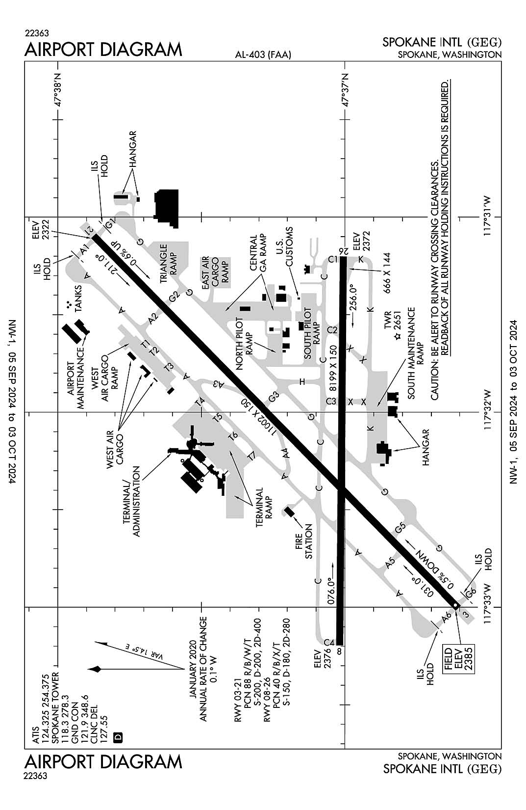
Spokane International
ICAO Identifier KGEG
Spokane, WA
Spokane Intl
ICAO Identifier KGEG
AD 2.2 Aerodrome Geographical and Administrative Data
2.2.1 Reference Point: 47-37-08.5N / 117-32-06.8W
2.2.2 From City: 5 miles SW of SPOKANE, WA
2.2.3 Elevation: 2385 ft
2.2.5 Magnetic Variation: 14E (2020)
2.2.6 Airport Contact: LAWRENCE J KRAUTER
9000 W AIRPORT DR.
SPOKANE, WA 99224 ((509) 455-6418)
2.2.7 Traffic: IFR/VFR
AD 2.3 Attendance Schedule
2.3.1 All Months, All Days, All Hours
AD 2.4 Handling Services and Facilities
2.4.1 Cargo Handling Facilities: YES
2.4.2 Fuel Types: 100 100LL A
2.4.5 Hangar Space: YES
2.4.6 Repair Facilities: MAJOR
AD 2.6 Rescue and Firefighting Services
2.6.1 Aerodrome Category: Class-I certified on 5/1/1973
2.6.2 Rescue and Firefighting Services: ARFF Index-C
AD 2.12 Runway Physical Characteristics
2.12.1 Designation: 03
2.12.2 True Bearing: 45
2.12.3 True Dimensions: 11002 ft x 150 ft
2.12.4 PCN: 88 R/B/W/T
2.12.5 Coordinates: 47-36-36.2909N / 117-33-00.2876W
2.12.6 Threshold Elevation: 2385
2.12.6 Touchdown Zone Elevation: 2385
2.12.1 Designation: 21
2.12.2 True Bearing: 225
2.12.3 True Dimensions: 11002 ft x 150 ft
2.12.4 PCN: 88 R/B/W/T
2.12.5 Coordinates: 47-37-52.3811N / 117-31-05.7573W
2.12.6 Threshold Elevation: 2322.4
2.12.6 Touchdown Zone Elevation: 2346.1
2.12.1 Designation: 08
2.12.2 True Bearing: 90
2.12.3 True Dimensions: 8199 ft x 150 ft
2.12.4 PCN: 40 R/B/X/T
2.12.5 Coordinates: 47-37-01.0687N / 117-33-11.7639W
2.12.6 Threshold Elevation: 2376.2
2.12.6 Touchdown Zone Elevation: 2376.2
2.12.1 Designation: 26
2.12.2 True Bearing: 270
2.12.3 True Dimensions: 8199 ft x 150 ft
2.12.4 PCN: 40 R/B/X/T
2.12.5 Coordinates: 47-37-00.3642N / 117-31-12.1045W
2.12.6 Threshold Elevation: 2371.5
2.12.6 Touchdown Zone Elevation: 2371.5
AD 2.13 Declared Distances
2.13.1 Designation: 03
2.13.2 Take-off Run Available: 11002
2.13.3 Take-off Distance Available: 11002
2.13.4 Accelerate-Stop Distance Available: 11002
2.13.5 Landing Distance Available: 11002
2.13.1 Designation: 21
2.13.2 Take-off Run Available: 11002
2.13.3 Take-off Distance Available: 11002
2.13.4 Accelerate-Stop Distance Available: 11002
2.13.5 Landing Distance Available: 11002
2.13.1 Designation: 08
2.13.2 Take-off Run Available: 8199
2.13.3 Take-off Distance Available: 8199
2.13.4 Accelerate-Stop Distance Available: 8199
2.13.5 Landing Distance Available: 8199
2.13.1 Designation: 26
2.13.2 Take-off Run Available: 8199
2.13.3 Take-off Distance Available: 8199
2.13.4 Accelerate-Stop Distance Available: 8199
2.13.5 Landing Distance Available: 8199
AD 2.14 Approach and Runway Lighting
2.14.1 Designation: 03
2.14.2 Approach Lighting System: ALSF2
2.14.4 Visual Approach Slope Indicator System: P4L
2.14.1 Designation: 21
2.14.2 Approach Lighting System: ALSF2
2.14.4 Visual Approach Slope Indicator System: P4L
2.14.1 Designation: 08
2.14.2 Approach Lighting System:
2.14.4 Visual Approach Slope Indicator System: P4R
2.14.1 Designation: 26
2.14.2 Approach Lighting System:
2.14.4 Visual Approach Slope Indicator System: P4L
AD 2.18 Air Traffic Services Communication Facilities
2.18.1 Service Designation: APCH/P DEP/P IC (205-025)
2.18.3 Channel: 123.75
2.18.5 Hours of Operation: 24
2.18.1 Service Designation: APCH/P DEP/P IC (026-204)
2.18.3 Channel: 133.35
2.18.5 Hours of Operation: 24
2.18.1 Service Designation: APCH/P DEP/P IC (026-204)
2.18.3 Channel: 263
2.18.5 Hours of Operation: 24
2.18.1 Service Designation: APCH/P DEP/P IC (205-025)
2.18.3 Channel: 282.25
2.18.5 Hours of Operation: 24
2.18.1 Service Designation: APCH/S DEP/S
2.18.3 Channel: 372.9
2.18.5 Hours of Operation: 24
2.18.1 Service Designation: ATIS
2.18.3 Channel: 124.325
2.18.5 Hours of Operation: 24
2.18.1 Service Designation: ATIS
2.18.3 Channel: 254.375
2.18.5 Hours of Operation: 24
2.18.1 Service Designation: CD/P
2.18.3 Channel: 127.55
2.18.5 Hours of Operation: 24
2.18.1 Service Designation: CLASS C (205-025)
2.18.3 Channel: 123.75
2.18.5 Hours of Operation: 24
2.18.1 Service Designation: CLASS C (026-204)
2.18.3 Channel: 133.35
2.18.5 Hours of Operation: 24
2.18.1 Service Designation: CLASS C (026-204)
2.18.3 Channel: 263
2.18.5 Hours of Operation: 24
2.18.1 Service Designation: CLASS C (205-025)
2.18.3 Channel: 282.25
2.18.5 Hours of Operation: 24
2.18.1 Service Designation: EMERG
2.18.3 Channel: 121.5
2.18.5 Hours of Operation:
2.18.1 Service Designation: EMERG
2.18.3 Channel: 243
2.18.5 Hours of Operation:
2.18.1 Service Designation: GND/P
2.18.3 Channel: 121.9
2.18.5 Hours of Operation: 24
2.18.1 Service Designation: GND/P
2.18.3 Channel: 348.6
2.18.5 Hours of Operation: 24
2.18.1 Service Designation: HILIE STAR
2.18.3 Channel: 133.35
2.18.5 Hours of Operation: 24
2.18.1 Service Designation: HILIE STAR
2.18.3 Channel: 263
2.18.5 Hours of Operation: 24
2.18.1 Service Designation: LCL/P
2.18.3 Channel: 118.3
2.18.5 Hours of Operation: 24
2.18.1 Service Designation: LCL/P
2.18.3 Channel: 278.3
2.18.5 Hours of Operation: 24
2.18.1 Service Designation: ZOOMR STAR
2.18.3 Channel: 123.75
2.18.5 Hours of Operation: 24
2.18.1 Service Designation: ZOOMR STAR
2.18.3 Channel: 282.25
2.18.5 Hours of Operation: 24
AD 2.19 Radio Navigation and Landing Aids
2.19.1 ILS Type: DME for runway 03. Magnetic variation: 14E
2.19.2 ILS Identification: OLJ
2.19.5 Coordinates: 47-36-32.05N / 117-33-15.1W
2.19.6 Site Elevation: 2380.2 ft
2.19.1 ILS Type: Glide Slop for runway 03. Magnetic variation: 14E
2.19.2 ILS Identification: OLJ
2.19.5 Coordinates: 47-36-47.5569N / 117-32-51.8755W
2.19.6 Site Elevation: 2372 ft
2.19.1 ILS Type: Localizer for runway 03. Magnetic variation: 14E
2.19.2 ILS Identification: OLJ
2.19.5 Coordinates: 47-37-59.6757N / 117-30-54.7682W
2.19.6 Site Elevation: 2315.7 ft
2.19.1 ILS Type: DME for runway 21. Magnetic variation: 14E
2.19.2 ILS Identification: GEG
2.19.5 Coordinates: 47-36-32.05N / 117-33-15.1W
2.19.6 Site Elevation: 2380.2 ft
2.19.1 ILS Type: Glide Slop for runway 21. Magnetic variation: 14E
2.19.2 ILS Identification: GEG
2.19.5 Coordinates: 47-37-48.959N / 117-31-19.4519W
2.19.6 Site Elevation: 2324.3 ft
2.19.1 ILS Type: Localizer for runway 21. Magnetic variation: 14E
2.19.2 ILS Identification: GEG
2.19.5 Coordinates: 47-36-29.2008N / 117-33-10.9524W
2.19.6 Site Elevation: 2380.1 ft
2.19.1 Navigation Aid Type VORTAC. Magnetic variation: 14E
2.19.2 Navigation Aid Identification: GEG
2.19.5 Coordinates: 47-33-53.805N / 117-37-36.789W
2.19.6 Site Elevation: 2756.3 ft
General Remarks:
PORTIONS OF TWY K NOT VISIBLE FM ATCT.
TWY K UNLGTD ON RAMP SIDE ALONG MAINTENANCE RAMP AND IS UNAVBL BELOW 1200 RVR UNLESS UNDER ESCORT BY "FOLLOW ME".
BE ALERT TO TURBULENCE OVER SMOKE STACKS 1 MILE EAST OF ARPT.
WATERFOWL & BIRDS ON & INVOF ARPT.