Maryland
Baltimore, Maryland
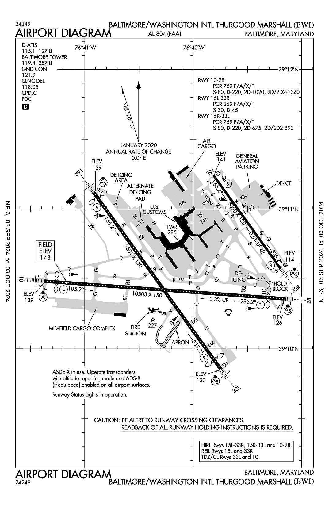
Baltimore-Washington International Thurgood Marshall
ICAO Identifier KBWI
Baltimore, MD
Baltimore/Washington Intl Thurgood Marshal
ICAO Identifier KBWI
AD 2.2 Aerodrome Geographical and Administrative Data
2.2.1 Reference Point: 39-10-32.622N / 76-40-08.368W
2.2.2 From City: 9 miles S of BALTIMORE, MD
2.2.3 Elevation: 143.4 ft
2.2.5 Magnetic Variation: 11W (2000)
2.2.6 Airport Contact: GREGORY SOLEK
PO BOX 8766
BWI AIRPORT, MD 21240 (410-859-7024)
2.2.7 Traffic: IFR/VFR
AD 2.3 Attendance Schedule
2.3.1 All Months, All Days, All Hours
AD 2.4 Handling Services and Facilities
2.4.1 Cargo Handling Facilities: YES
2.4.2 Fuel Types: 100LL A
2.4.5 Hangar Space: YES
2.4.6 Repair Facilities: MAJOR
AD 2.6 Rescue and Firefighting Services
2.6.1 Aerodrome Category: Class-I certified on 5/1/1973
2.6.2 Rescue and Firefighting Services: ARFF Index-D
AD 2.12 Runway Physical Characteristics
2.12.1 Designation: 10
2.12.2 True Bearing: 94
2.12.3 True Dimensions: 10503 ft x 150 ft
2.12.4 PCN:
2.12.5 Coordinates: 39-10-29.0895N / 76-41-22.6248W
2.12.6 Threshold Elevation: 139
2.12.6 Touchdown Zone Elevation: 143.4
2.12.1 Designation: 28
2.12.2 True Bearing: 274
2.12.3 True Dimensions: 10503 ft x 150 ft
2.12.4 PCN:
2.12.5 Coordinates: 39-10-21.4754N / 76-39-09.6234W
2.12.6 Threshold Elevation: 126.4
2.12.6 Touchdown Zone Elevation: 142.7
2.12.1 Designation: 33R
2.12.2 True Bearing: 324
2.12.3 True Dimensions: 5000 ft x 100 ft
2.12.4 PCN:
2.12.5 Coordinates: 39-10-34.4468N / 76-39-11.6307W
2.12.6 Threshold Elevation: 114
2.12.6 Touchdown Zone Elevation: 124.4
2.12.1 Designation: 15L
2.12.2 True Bearing: 144
2.12.3 True Dimensions: 5000 ft x 100 ft
2.12.4 PCN:
2.12.5 Coordinates: 39-11-14.5431N / 76-39-48.7441W
2.12.6 Threshold Elevation: 141.4
2.12.6 Touchdown Zone Elevation: 141.5
2.12.1 Designation: 33L
2.12.2 True Bearing: 324
2.12.3 True Dimensions: 9501 ft x 150 ft
2.12.4 PCN:
2.12.5 Coordinates: 39-09-51.1311N / 76-39-44.6134W
2.12.6 Threshold Elevation: 129.6
2.12.6 Touchdown Zone Elevation: 142.7
2.12.1 Designation: 15R
2.12.2 True Bearing: 144
2.12.3 True Dimensions: 9501 ft x 150 ft
2.12.4 PCN:
2.12.5 Coordinates: 39-11-07.3007N / 76-40-55.1704W
2.12.6 Threshold Elevation: 139
2.12.6 Touchdown Zone Elevation: 138.3
AD 2.13 Declared Distances
2.13.1 Designation: 10
2.13.2 Take-off Run Available: 10503
2.13.3 Take-off Distance Available: 10503
2.13.4 Accelerate-Stop Distance Available: 10503
2.13.5 Landing Distance Available: 9953
2.13.1 Designation: 28
2.13.2 Take-off Run Available: 10503
2.13.3 Take-off Distance Available: 10503
2.13.4 Accelerate-Stop Distance Available: 10503
2.13.5 Landing Distance Available: 9803
2.13.1 Designation: 33R
2.13.2 Take-off Run Available: 5000
2.13.3 Take-off Distance Available: 5000
2.13.4 Accelerate-Stop Distance Available: 5000
2.13.5 Landing Distance Available: 5000
2.13.1 Designation: 15L
2.13.2 Take-off Run Available: 5000
2.13.3 Take-off Distance Available: 5000
2.13.4 Accelerate-Stop Distance Available: 5000
2.13.5 Landing Distance Available: 5000
2.13.1 Designation: 33L
2.13.2 Take-off Run Available: 9501
2.13.3 Take-off Distance Available: 9501
2.13.4 Accelerate-Stop Distance Available: 8801
2.13.5 Landing Distance Available: 8301
2.13.1 Designation: 15R
2.13.2 Take-off Run Available: 9501
2.13.3 Take-off Distance Available: 9501
2.13.4 Accelerate-Stop Distance Available: 8601
2.13.5 Landing Distance Available: 8301
AD 2.14 Approach and Runway Lighting
2.14.1 Designation: 10
2.14.2 Approach Lighting System: ALSF2
2.14.4 Visual Approach Slope Indicator System: P4R
2.14.1 Designation: 28
2.14.2 Approach Lighting System: MALSR
2.14.4 Visual Approach Slope Indicator System: P4L
2.14.1 Designation: 33R
2.14.2 Approach Lighting System: MALSR
2.14.4 Visual Approach Slope Indicator System: P4L
2.14.1 Designation: 15L
2.14.2 Approach Lighting System:
2.14.4 Visual Approach Slope Indicator System: P4L
2.14.1 Designation: 33L
2.14.2 Approach Lighting System: MALSR
2.14.4 Visual Approach Slope Indicator System: P4L
2.14.1 Designation: 15R
2.14.2 Approach Lighting System: MALSR
2.14.4 Visual Approach Slope Indicator System: P4R
AD 2.18 Air Traffic Services Communication Facilities
2.18.1 Service Designation: CD/P
2.18.3 Channel: 118.05
2.18.5 Hours of Operation: 24
2.18.1 Service Designation: D-ATIS
2.18.3 Channel: 115.1
2.18.5 Hours of Operation: 24
2.18.1 Service Designation: D-ATIS
2.18.3 Channel: 127.8
2.18.5 Hours of Operation: 24
2.18.1 Service Designation: EMERG
2.18.3 Channel: 121.5
2.18.5 Hours of Operation:
2.18.1 Service Designation: EMERG
2.18.3 Channel: 243
2.18.5 Hours of Operation:
2.18.1 Service Designation: GND/P
2.18.3 Channel: 121.9
2.18.5 Hours of Operation: 24
2.18.1 Service Designation: LCL/P
2.18.3 Channel: 119.4
2.18.5 Hours of Operation: 24
2.18.1 Service Designation: LCL/P
2.18.3 Channel: 257.8
2.18.5 Hours of Operation: 24
AD 2.19 Radio Navigation and Landing Aids
2.19.1 ILS Type: Glide Slop for runway 10. Magnetic variation: 11W
2.19.2 ILS Identification: BAL
2.19.5 Coordinates: 39-10-23.557N / 76-41-03.233W
2.19.6 Site Elevation: 137.6 ft
2.19.1 ILS Type: Localizer for runway 10. Magnetic variation: 11W
2.19.2 ILS Identification: BAL
2.19.5 Coordinates: 39-10-20.5919N / 76-38-54.2857W
2.19.6 Site Elevation: 137.5 ft
2.19.1 ILS Type: Glide Slop for runway 28. Magnetic variation: 11W
2.19.2 ILS Identification: OEH
2.19.5 Coordinates: 39-10-18.64N / 76-39-31.024W
2.19.6 Site Elevation: 129.2 ft
2.19.1 ILS Type: Localizer for runway 28. Magnetic variation: 11W
2.19.2 ILS Identification: OEH
2.19.5 Coordinates: 39-10-29.8183N / 76-41-35.4222W
2.19.6 Site Elevation: 134 ft
2.19.1 ILS Type: Glide Slop for runway 15L. Magnetic variation: 11W
2.19.2 ILS Identification: UQC
2.19.5 Coordinates: 39-11-03.67N / 76-39-44.24W
2.19.6 Site Elevation: 138.1 ft
2.19.1 ILS Type: Localizer for runway 15L. Magnetic variation: 11W
2.19.2 ILS Identification: UQC
2.19.5 Coordinates: 39-10-29.3978N / 76-39-06.9539W
2.19.6 Site Elevation: 94 ft
2.19.1 ILS Type: Glide Slop for runway 33R. Magnetic variation: 11W
2.19.2 ILS Identification: BWI
2.19.5 Coordinates: 39-10-40.05N / 76-39-21.19W
2.19.6 Site Elevation: 110.3 ft
2.19.1 ILS Type: Localizer for runway 33R. Magnetic variation: 11W
2.19.2 ILS Identification: BWI
2.19.5 Coordinates: 39-11-19.7555N / 76-39-53.5728W
2.19.6 Site Elevation: 133 ft
2.19.1 ILS Type: Glide Slop for runway 15R. Magnetic variation: 11W
2.19.2 ILS Identification: FND
2.19.5 Coordinates: 39-10-53.6029N / 76-40-48.8976W
2.19.6 Site Elevation: 130.2 ft
2.19.1 ILS Type: Localizer for runway 15R. Magnetic variation: 11W
2.19.2 ILS Identification: FND
2.19.5 Coordinates: 39-09-39.0861N / 76-39-33.4607W
2.19.6 Site Elevation: 115.9 ft
2.19.1 ILS Type: Glide Slop for runway 33L. Magnetic variation: 11W
2.19.2 ILS Identification: RUX
2.19.5 Coordinates: 39-10-00.5283N / 76-39-59.734W
2.19.6 Site Elevation: 125.6 ft
2.19.1 ILS Type: Localizer for runway 33L. Magnetic variation: 11W
2.19.2 ILS Identification: RUX
2.19.5 Coordinates: 39-11-12.2145N / 76-40-59.7239W
2.19.6 Site Elevation: 133 ft
General Remarks:
NO APRON PARKING FOR UNSKED ACR.
GA ACFT CTC 129.0 PRIOR TO ARR AT GA RAMP FOR SCTY PURPOSES.
TWY 'A' IS RSTRD TO GROUP IV ACFT WINGSPAN 171 FT OR LESS.
RWY STATUS LGTS IN OPN.
DISTRACTING LGTS (GOLF DRIVING RANGE) RIGHT SIDE EXTDD CNTRLN RWY 33L FM AER TO 1/4 MI FINAL.
ACFT DEPARTING RWY 28 EXP DEP FM TWY U1.
DURING ATC ZERO EVENTS, UNICOM 119.4.
ACFT ON VISUAL APCHS EXPECT TO MAINTAIN 3000 FT UNTIL 10 DME FM BAL VORTAC; DEP ACFT SHOULD EXPECT TURNS BASED ON BALTIMORE DME.
DEER & BIRDS OCNLLY ON & INVOF ARPT.
PRACTICE LNDG & APCH BY TURBO-PWRD ACFT PROHIBITED 2200-0600; PRACTICE LNDG & TKOF BY B-747 ACFT PROHIBITED RWY 15R/33L.
RWY 28 DE-ICE PAD LANE 1 RSTRD TO ACFT WITH WINGSPAN 171 FT OR LESS, LANE 2 RSTRD TO ACFT WITH WINGSPAN 135 FT OR LESS, LANE 3 IS USED BY LARGE ACFT MAX WINGSPAN 215 FT AND WHEN IN USE- LANES 2 AND 4 ARE UNAVBL. LANES 4, 5 & 6 ARE RSTRD TO ACFT WINGSPAN 135 FT OR LESS.
RWY 15R DEICE PAD, POSITION # 1, RSTRD TO ACFT WITH WINGSPAN OF 156 FT 1 INCH OR LESS & LENGTH OF 180 FT 3 INCHES OR LESS. PSN'S #2 & #3 ARE RSTD TO ACFT WITH A WINGSPAN OF 156 FT 1 INCH OR LESS, POSITION #3 IS RSTRD TO ACFT WITH A WINGSPAN OF 156 FT 1 INCH OR LESS & LENGTH OF 180 FT 3 INCHES OR LESS; POSITION 4 RSTRD TO ACFT WITH WINGSPAN OF 213 FT OR LESS & LENGTH OF 229 FT 2 INCHES OR LESS.
RWY LEN AVBL FOR RWY 28 DEPS FM TWY U1 IS 9802 FT.
MAJOR CONSTR ON ARPT DLY; ACFT MOV & PRKG AREAS SUBJECT TO SHORT NOTICE CHANGE/CLOSURE. FOR CURRENT INFO PHONE BWI OPNS CNTR 410-859-7018.
CONCOURSE A ALT DEICING AREA IS RSTRD TO B737-800 SIZE ACFT WITH WINGLETS OR SMLR ON SPOTS 6, 7 AND 8.
TAXIING PROHIBITED BTN CONCOURSE C & ADJ BLDG STRUCTURE SW OF CONCOURSE C. ACCESS TO GATE C12 MUST BE VIA TWY A.
TWY T BTN TWY H AND TWY E RSTD TO GROUP IV ACFT WITH WINGSPAN LESS THAN 171 FT. TWY T BTN TWY E AND TWY B RSTRD TO GROUP V ACFT WITH WINGSPAN LESS THAN 214 FT; WHEN GROUP V ACFT ARE ON TWY T, TWY A IS RSTRD TO MAX WINGSPANS OF 110 FT.
TWY "S", SOUTH OF TWY "P", RSTRD TO ACFT 60000 LBS & LESS.
TAXILANES 'T-1' & "H" RSTRD TO GROUP III ACFT WITH MAX WINGSPAN OF 118 FEET.
NOISE ABATEMENT PROCEDURES IN EFFECT - RSTRN FOR RWY 15L/33R EXCEPT FOR EMERG OR MERCY FLIGHTS CTC AMGR FOR INFO.
CONT MOWING OPERATIONS ADJ ALL RWYS & TWYS - APR THRU NOV.
UNICOM 119.4.
DUAL PARALLEL TAXILANES HAVE BEEN ADDED TO THE 'D'/'E' ALLEYWAY; TAXILANE 'N' AND TAXILANE 'N1'. TAXILANE 'N' IS DESIGNATED A "GROUP V" TAXILANE WITH MAX WINGSPAN OF 213 FT. TAXILANE 'N1' IS DESIGNATED A "GROUP IV" TAXILANE WITH MAX WINGSPAN OF 170 FT.