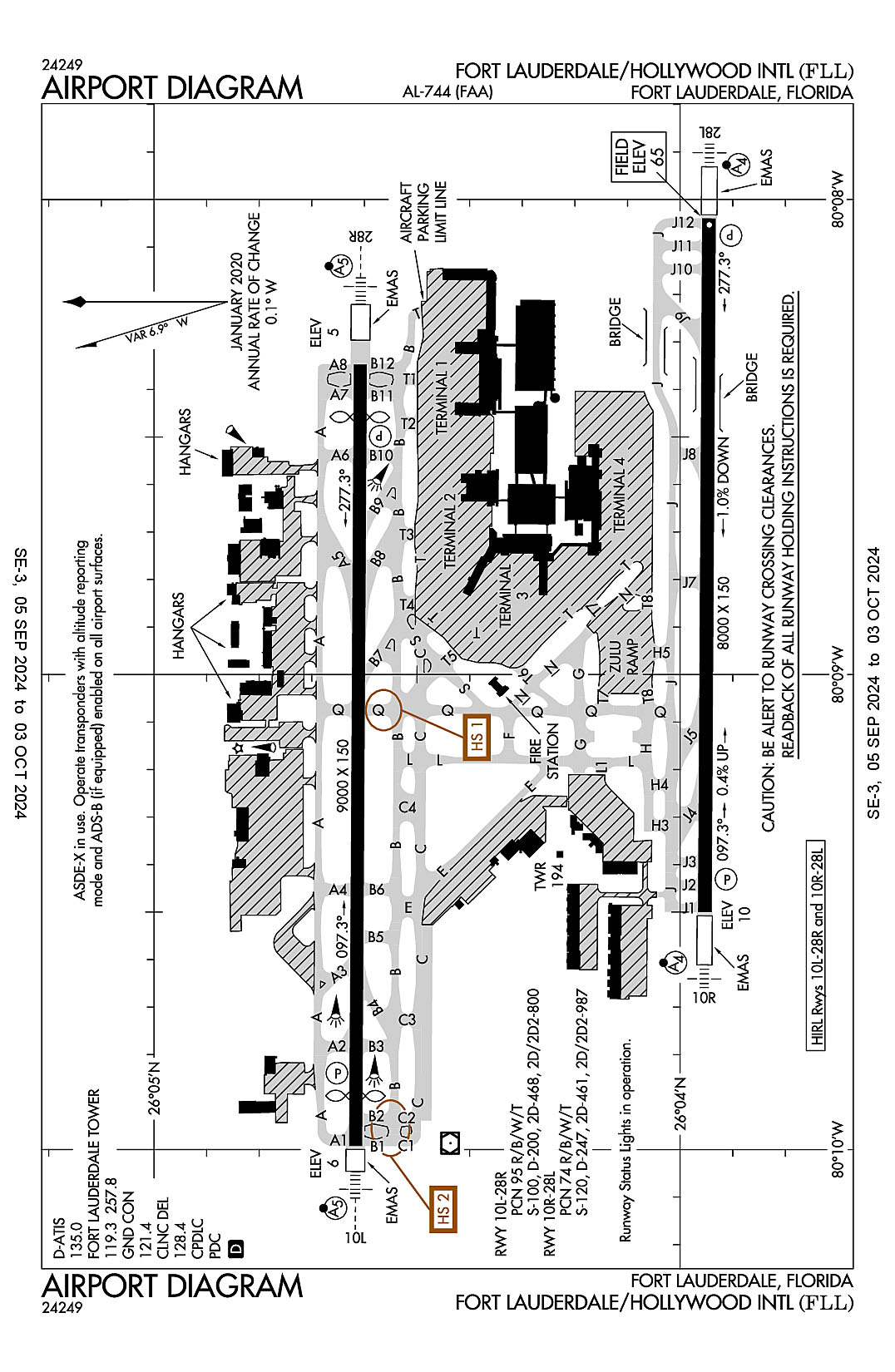
Florida
Fort Lauderdale, Florida
Fort Lauderdale-Hollywood International
ICAO Identifier KFLL
Fort Lauderdale, FL
Fort Lauderdale/Hollywood Intl
ICAO Identifier KFLL
AD 2.2 Aerodrome Geographical and Administrative Data
2.2.1 Reference Point: 26-04-18N / 80-08-58.9W
2.2.2 From City: 3 miles SW of FORT LAUDERDALE, FL
2.2.3 Elevation: 65 ft
2.2.5 Magnetic Variation: 6W (2015)
2.2.6 Airport Contact: MARK GALE
320 TERMINAL DRIVE SUITE 200
FORT LAUDERDALE, FL 33315 (954-359-6100)
2.2.7 Traffic: IFR/VFR
AD 2.3 Attendance Schedule
2.3.1 All Months, All Days, All Hours
AD 2.4 Handling Services and Facilities
2.4.1 Cargo Handling Facilities: YES
2.4.2 Fuel Types: 100LL A
2.4.5 Hangar Space: YES
2.4.6 Repair Facilities: MAJOR
AD 2.6 Rescue and Firefighting Services
2.6.1 Aerodrome Category: Class-I certified on 5/21/1973
2.6.2 Rescue and Firefighting Services: ARFF Index-E
AD 2.12 Runway Physical Characteristics
2.12.1 Designation: 10L
2.12.2 True Bearing: 90
2.12.3 True Dimensions: 9000 ft x 150 ft
2.12.4 PCN: 95 R/B/W/T
2.12.5 Coordinates: 26-04-37.0166N / 80-09-59.5381W
2.12.6 Threshold Elevation: 5.6
2.12.6 Touchdown Zone Elevation: 7.1
2.12.1 Designation: 28R
2.12.2 True Bearing: 270
2.12.3 True Dimensions: 9000 ft x 150 ft
2.12.4 PCN: 95 R/B/W/T
2.12.5 Coordinates: 26-04-36.4507N / 80-08-20.835W
2.12.6 Threshold Elevation: 5.3
2.12.6 Touchdown Zone Elevation: 6.7
2.12.1 Designation: 10R
2.12.2 True Bearing: 90
2.12.3 True Dimensions: 8000 ft x 150 ft
2.12.4 PCN: 74 R/B/W/T
2.12.5 Coordinates: 26-03-57.1919N / 80-09-30.056W
2.12.6 Threshold Elevation: 10.1
2.12.6 Touchdown Zone Elevation: 14.3
2.12.1 Designation: 28L
2.12.2 True Bearing: 270
2.12.3 True Dimensions: 8000 ft x 150 ft
2.12.4 PCN: 74 R/B/W/T
2.12.5 Coordinates: 26-03-56.6718N / 80-08-02.3388W
2.12.6 Threshold Elevation: 65
2.12.6 Touchdown Zone Elevation: 65
AD 2.13 Declared Distances
2.13.1 Designation: 10L
2.13.2 Take-off Run Available: 9000
2.13.3 Take-off Distance Available: 9000
2.13.4 Accelerate-Stop Distance Available: 9000
2.13.5 Landing Distance Available: 8424
2.13.1 Designation: 28R
2.13.2 Take-off Run Available: 9000
2.13.3 Take-off Distance Available: 9000
2.13.4 Accelerate-Stop Distance Available: 9000
2.13.5 Landing Distance Available: 8394
2.13.1 Designation: 10R
2.13.2 Take-off Run Available: 8000
2.13.3 Take-off Distance Available: 8000
2.13.4 Accelerate-Stop Distance Available: 8000
2.13.5 Landing Distance Available: 8000
2.13.1 Designation: 28L
2.13.2 Take-off Run Available: 8000
2.13.3 Take-off Distance Available: 8000
2.13.4 Accelerate-Stop Distance Available: 8000
2.13.5 Landing Distance Available: 8000
AD 2.14 Approach and Runway Lighting
2.14.1 Designation: 10L
2.14.2 Approach Lighting System: MALSR
2.14.4 Visual Approach Slope Indicator System: P4L
2.14.1 Designation: 28R
2.14.2 Approach Lighting System: MALSR
2.14.4 Visual Approach Slope Indicator System: P4L
2.14.1 Designation: 10R
2.14.2 Approach Lighting System: MALSF
2.14.4 Visual Approach Slope Indicator System: P4R
2.14.1 Designation: 28L
2.14.2 Approach Lighting System: MALSF
2.14.4 Visual Approach Slope Indicator System: P4L
AD 2.18 Air Traffic Services Communication Facilities
2.18.1 Service Designation: CD PRE TAXI CLNC
2.18.3 Channel: 128.4
2.18.5 Hours of Operation: 24
2.18.1 Service Designation: D-ATIS
2.18.3 Channel: 135
2.18.5 Hours of Operation: 24
2.18.1 Service Designation: GND/P
2.18.3 Channel: 121.4
2.18.5 Hours of Operation: 24
2.18.1 Service Designation: GND/S
2.18.3 Channel: 121.7
2.18.5 Hours of Operation: 24
2.18.1 Service Designation: LCL/P
2.18.3 Channel: 119.3
2.18.5 Hours of Operation: 24
2.18.1 Service Designation: LCL/P
2.18.3 Channel: 257.8
2.18.5 Hours of Operation: 24
2.18.1 Service Designation: LCL/S
2.18.3 Channel: 120.2
2.18.5 Hours of Operation: 24
2.18.1 Service Designation: RAMP CTL (NORTH)
2.18.3 Channel: 118.175
2.18.5 Hours of Operation:
2.18.1 Service Designation: RAMP CTL (SOUTH)
2.18.3 Channel: 129.875
2.18.5 Hours of Operation:
AD 2.19 Radio Navigation and Landing Aids
2.19.1 ILS Type: DME for runway 10L. Magnetic variation: 6W
2.19.2 ILS Identification: LHI
2.19.5 Coordinates: 26-04-40.1757N / 80-08-15.6721W
2.19.6 Site Elevation: 11.3 ft
2.19.1 ILS Type: Glide Slop for runway 10L. Magnetic variation: 6W
2.19.2 ILS Identification: LHI
2.19.5 Coordinates: 26-04-39.6411N / 80-09-42.3329W
2.19.6 Site Elevation: 2.9 ft
2.19.1 ILS Type: Localizer for runway 10L. Magnetic variation: 6W
2.19.2 ILS Identification: LHI
2.19.5 Coordinates: 26-04-36.4066N / 80-08-13.1434W
2.19.6 Site Elevation: 4.3 ft
2.19.1 ILS Type: DME for runway 28R. Magnetic variation: 6W
2.19.2 ILS Identification: UDL
2.19.5 Coordinates: 26-04-34.5346N / 80-10-02.4136W
2.19.6 Site Elevation: 10.4 ft
2.19.1 ILS Type: Glide Slop for runway 28R. Magnetic variation: 6W
2.19.2 ILS Identification: UDL
2.19.5 Coordinates: 26-04-39.627N / 80-08-39.0644W
2.19.6 Site Elevation: 5 ft
2.19.1 ILS Type: Localizer for runway 28R. Magnetic variation: 6W
2.19.2 ILS Identification: UDL
2.19.5 Coordinates: 26-04-37.0351N / 80-10-02.8297W
2.19.6 Site Elevation: 4.6 ft
2.19.1 ILS Type: DME for runway 10R. Magnetic variation: 6W
2.19.2 ILS Identification: FLL
2.19.5 Coordinates: 26-03-58.8348N / 80-07-55.7162W
2.19.6 Site Elevation: 68.3 ft
2.19.1 ILS Type: Glide Slop for runway 10R. Magnetic variation: 6W
2.19.2 ILS Identification: FLL
2.19.5 Coordinates: 26-03-53.1134N / 80-09-18.5896W
2.19.6 Site Elevation: 5.7 ft
2.19.1 ILS Type: Localizer for runway 10R. Magnetic variation: 6W
2.19.2 ILS Identification: FLL
2.19.5 Coordinates: 26-03-56.6314N / 80-07-55.5666W
2.19.6 Site Elevation: 64.4 ft
2.19.1 ILS Type: DME for runway 28L. Magnetic variation: 6W
2.19.2 ILS Identification: ADI
2.19.5 Coordinates: 26-03-59.4802N / 80-09-40.4489W
2.19.6 Site Elevation: 14.7 ft
2.19.1 ILS Type: Glide Slop for runway 28L. Magnetic variation: 6W
2.19.2 ILS Identification: ADI
2.19.5 Coordinates: 26-03-52.7404N / 80-08-15.5298W
2.19.6 Site Elevation: 45 ft
2.19.1 ILS Type: Localizer for runway 28L. Magnetic variation: 6W
2.19.2 ILS Identification: ADI
2.19.5 Coordinates: 26-03-57.2361N / 80-09-37.7655W
2.19.6 Site Elevation: 7.5 ft
2.19.1 Navigation Aid Type VOR/DME. Magnetic variation: 6W
2.19.2 Navigation Aid Identification: FLL
2.19.5 Coordinates: 26-04-26.1833N / 80-09-59.1921W
2.19.6 Site Elevation: 5.6 ft
General Remarks:
PPR FOR ACFT WITH EXPLOSIVES.
TWY E BTN TWY C & TWY L CLSD TO ACFT WINGSPAN MORE THAN 118 FT EXC 10 MIN PPR 954-816-3179.
ARR FM N & W MNTN 6000 FT UNTIL ABM RWY 28R ON DOWNWIND; ARR FM N MNTN 6000 FT UNTIL ABM RWY 10L ON DOWNWIND.
EAST SIDE OF CONCOURSE B AVBL TO ACFT WITH WINGSPAN LESS THAN 124.9 FT.
DO NOT MISTAKE TAXIWAY B FOR LANDING/TAKEOFF SURFACE.
ARFF INDEX C AVBL UPON REQ.
ALL RWYS NOISE SENSITIVE; NOISE ABATEMENT IN EFCT - 954-359-6181.
RWY 10L/28R NRS UNGROOVED AREAS.
RWY STATUS LIGHTS IN OPRN.
NO VFR APCHS OR BASE LEGS UNTIL OFFSHORE.
TURB BLW 1000 FT OVR LANDFILL LCTD 2 NM W.
JET RUNUPS NA 2300-0700.
ACFT OPRG FROM TRML 1, 2, 3, 4 MUST CTC RAMP CTL. RAMP CTL EFF - CTC ARPT OPS FOR HRS.
DO NOT MISTAKE TWY B FOR LNDG/TKOF SFC.
IR CARRIER ACFT USE RAMP PUSH BACK PROCS PRESCRIBED BY ARPT OPS.
TWY J BGN TO ELEV 900 FT EAST OF TWY Q. DUE TO ELEV ALL ACFT REMAIN ON CNTRLN; TWY T8 & TAXILANE T NOT ACCESSIBLE FM TWY J.
ACFT LDG RWY 10R & EXITING J9 FOLLOW TWY LEAD OFF LINE ONTO J9.
NMRS TREES SW QUADRANT OF ARPT.
BIRDS ON & INVOF ARPT; CONCENTRATION OF BIRDS BLW 500 FT 2.0 NM W OF 10L & 10R AER.
TWY B E OF TWY B12 & TXL T E OF TWY T1 CLSD TO ACFT WITH WINGSPAN GTR THAN 118 FT & TAIL HGT GTR THAN 45 FT EXC PPR 954-816-3179.
APN TWY T EAST OF TWY T8 CLSD TO ACFT WINGSPAN MORE THAN 118 FT AND TAIL HEIGHT MORE THAN 45FT EXC ACFT UNDER TOW.
CLSD TO ACR TRAINING; LRG ACFT TRNG OVER 58000 LBS MAX CERTD GROSS TKOF WEIGHT; ALL TRNG 2300-0700.
PREFERENTIAL RWY USE PROGRAM IN EFCT; CTC NOISE ABATEMENT OFFICE.
TWY A BTN TWY A2 & TWY A3 CLSD TO ACFT WINGSPAN MORE THAN 171 FT & TAIL HGT MORE THAN 60 FT EXC PPR 954-816-3179.
TXL T BTN T7 AND T8 CLSD TO ACFT WINGSPAN MORE THAN 171 FT.
HIGH LIGHT MASTS WNW APCH END RWY 28L.
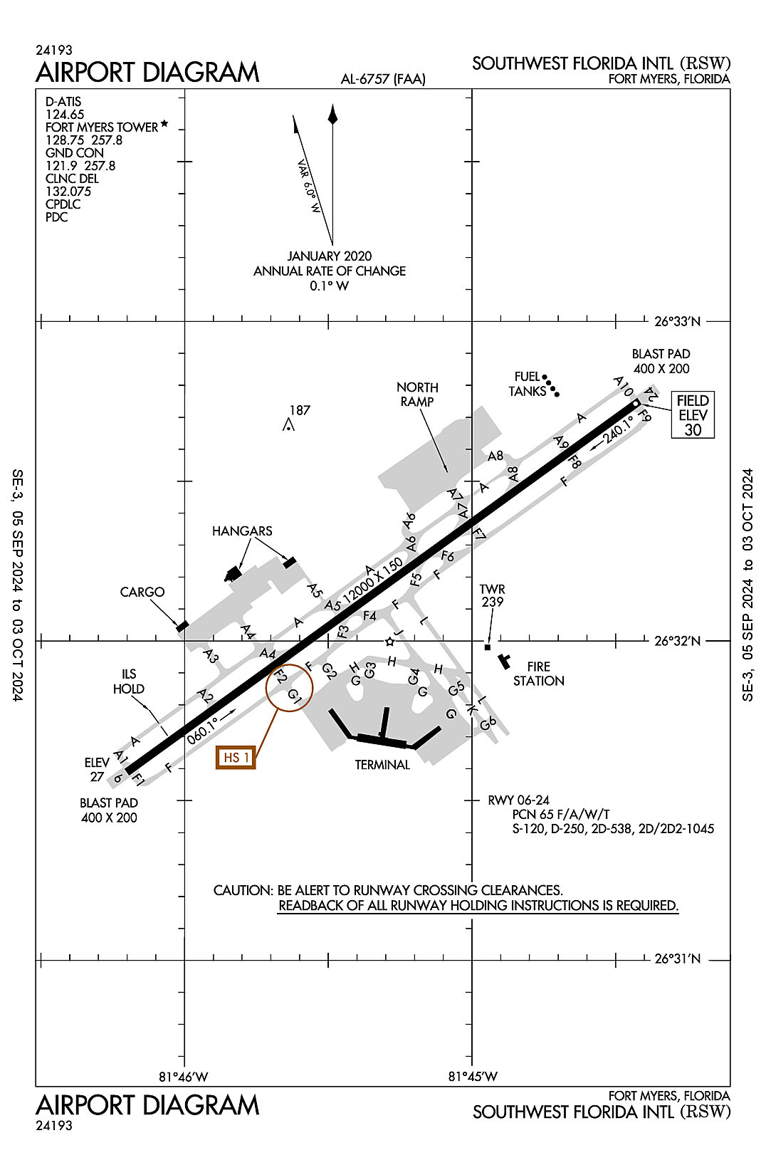
Fort Myers, Florida
Southwest Florida International
ICAO Identifier KRSW
Fort Myers, FL
Southwest Florida Intl
ICAO Identifier KRSW
AD 2.2 Aerodrome Geographical and Administrative Data
2.2.1 Reference Point: 26-32-10.19N / 81-45-18.558W
2.2.2 From City: 10 miles SE of FORT MYERS, FL
2.2.3 Elevation: 29.9 ft
2.2.5 Magnetic Variation: 4W (2000)
2.2.6 Airport Contact: STEVEN HENNIGAN
11000 TERMINAL ACCESS RD.
FORT MYERS, FL 33913 (239-590-4400)
2.2.7 Traffic: IFR/VFR
AD 2.3 Attendance Schedule
2.3.1 All Months, All Days, 0700-0100 Hours
AD 2.4 Handling Services and Facilities
2.4.1 Cargo Handling Facilities: YES
2.4.2 Fuel Types: 100LL A A+
2.4.5 Hangar Space: YES
2.4.6 Repair Facilities: MAJOR
AD 2.6 Rescue and Firefighting Services
2.6.1 Aerodrome Category: Class-I certified on 5/1/1983
2.6.2 Rescue and Firefighting Services: ARFF Index-D
AD 2.12 Runway Physical Characteristics
2.12.1 Designation: 24
2.12.2 True Bearing: 234
2.12.3 True Dimensions: 12000 ft x 150 ft
2.12.4 PCN: 65 F/A/W/T
2.12.5 Coordinates: 26-32-45.0262N / 81-44-25.0374W
2.12.6 Threshold Elevation: 29.8
2.12.6 Touchdown Zone Elevation: 29.9
2.12.1 Designation: 06
2.12.2 True Bearing: 54
2.12.3 True Dimensions: 12000 ft x 150 ft
2.12.4 PCN: 65 F/A/W/T
2.12.5 Coordinates: 26-31-35.3489N / 81-46-12.0692W
2.12.6 Threshold Elevation: 26.6
2.12.6 Touchdown Zone Elevation: 27
AD 2.13 Declared Distances
2.13.1 Designation: 24
2.13.2 Take-off Run Available:
2.13.3 Take-off Distance Available:
2.13.4 Accelerate-Stop Distance Available:
2.13.5 Landing Distance Available:
2.13.1 Designation: 06
2.13.2 Take-off Run Available:
2.13.3 Take-off Distance Available:
2.13.4 Accelerate-Stop Distance Available:
2.13.5 Landing Distance Available:
AD 2.14 Approach and Runway Lighting
2.14.1 Designation: 24
2.14.2 Approach Lighting System:
2.14.4 Visual Approach Slope Indicator System: P4L
2.14.1 Designation: 06
2.14.2 Approach Lighting System: MALSR
2.14.4 Visual Approach Slope Indicator System: P4L
AD 2.18 Air Traffic Services Communication Facilities
2.18.1 Service Designation: ALICO DP (RWY 06)
2.18.3 Channel: 126.8
2.18.5 Hours of Operation: 0600-0000
2.18.1 Service Designation: ALICO DP (RWY 24)
2.18.3 Channel: 134.425
2.18.5 Hours of Operation: 0600-0000
2.18.1 Service Designation: ALICO DP (RWY 06/24)
2.18.3 Channel: 306.2
2.18.5 Hours of Operation: 0600-0000
2.18.1 Service Designation: APCH/P DEP/P (121-240)
2.18.3 Channel: 124.125
2.18.5 Hours of Operation: 0600-0000
2.18.1 Service Designation: APCH/P DEP/P (001-120)
2.18.3 Channel: 126.8
2.18.5 Hours of Operation: 0600-0000
2.18.1 Service Designation: APCH/P DEP/P (301-360)
2.18.3 Channel: 127.05
2.18.5 Hours of Operation: 0600-0000
2.18.1 Service Designation: APCH/P DEP/P (241-300)
2.18.3 Channel: 134.425
2.18.5 Hours of Operation: 0600-0000
2.18.1 Service Designation: APCH/P DEP/P (241-120)
2.18.3 Channel: 306.2
2.18.5 Hours of Operation: 0600-0000
2.18.1 Service Designation: APCH/P DEP/P (121-240)
2.18.3 Channel: 371.85
2.18.5 Hours of Operation: 0600-0000
2.18.1 Service Designation: APCH/P DEP/P IC
2.18.3 Channel: 306.2
2.18.5 Hours of Operation: 0600-0000
2.18.1 Service Designation: APCH/P IC (RWY 06)
2.18.3 Channel: 125.15
2.18.5 Hours of Operation: 0600-0000
2.18.1 Service Designation: APCH/P IC (RWY 24)
2.18.3 Channel: 126.8
2.18.5 Hours of Operation: 0600-0000
2.18.1 Service Designation: CD/P
2.18.3 Channel: 132.075
2.18.5 Hours of Operation: 0600-0000
2.18.1 Service Designation: CLASS C (121-240)
2.18.3 Channel: 124.125
2.18.5 Hours of Operation: 0600-0000
2.18.1 Service Designation: CLASS C (001-120)
2.18.3 Channel: 126.8
2.18.5 Hours of Operation: 0600-0000
2.18.1 Service Designation: CLASS C (301-360)
2.18.3 Channel: 127.05
2.18.5 Hours of Operation: 0600-0000
2.18.1 Service Designation: CLASS C (241-300)
2.18.3 Channel: 134.425
2.18.5 Hours of Operation: 0600-0000
2.18.1 Service Designation: CLASS C (241-120)
2.18.3 Channel: 306.2
2.18.5 Hours of Operation: 0600-0000
2.18.1 Service Designation: CLASS C (121-240)
2.18.3 Channel: 371.85
2.18.5 Hours of Operation: 0600-0000
2.18.1 Service Designation: CSHEL DP (RWY 06)
2.18.3 Channel: 126.8
2.18.5 Hours of Operation: 0600-0000
2.18.1 Service Designation: CSHEL DP (RWY 24)
2.18.3 Channel: 134.425
2.18.5 Hours of Operation: 0600-0000
2.18.1 Service Designation: CSHEL DP (RWY 06/24)
2.18.3 Channel: 306.2
2.18.5 Hours of Operation: 0600-0000
2.18.1 Service Designation: D-ATIS
2.18.3 Channel: 124.65
2.18.5 Hours of Operation: 24
2.18.1 Service Designation: GND/P
2.18.3 Channel: 121.9
2.18.5 Hours of Operation: 0600-0000
2.18.1 Service Designation: GND/P
2.18.3 Channel: 257.8
2.18.5 Hours of Operation: 0600-0000
2.18.1 Service Designation: JOSFF STAR
2.18.3 Channel: 134.425
2.18.5 Hours of Operation: 0600-0000
2.18.1 Service Designation: JOSFF STAR
2.18.3 Channel: 306.2
2.18.5 Hours of Operation: 0600-0000
2.18.1 Service Designation: LCL/P
2.18.3 Channel: 128.75
2.18.5 Hours of Operation: 0600-0000
2.18.1 Service Designation: LCL/P
2.18.3 Channel: 257.8
2.18.5 Hours of Operation: 0600-0000
2.18.1 Service Designation: MOOKY DP (RWY 06)
2.18.3 Channel: 124.125
2.18.5 Hours of Operation: 0600-0000
2.18.1 Service Designation: MOOKY DP (RWY 24)
2.18.3 Channel: 134.425
2.18.5 Hours of Operation: 0600-0000
2.18.1 Service Designation: MOOKY DP (RWY 24)
2.18.3 Channel: 306.2
2.18.5 Hours of Operation: 0600-0000
2.18.1 Service Designation: MOOKY DP (RWY 06)
2.18.3 Channel: 371.85
2.18.5 Hours of Operation: 0600-0000
2.18.1 Service Designation: PUMPP STAR
2.18.3 Channel: 134.425
2.18.5 Hours of Operation: 0600-0000
2.18.1 Service Designation: PUMPP STAR
2.18.3 Channel: 306.2
2.18.5 Hours of Operation: 0600-0000
2.18.1 Service Designation: SCUBY DP
2.18.3 Channel: 124.125
2.18.5 Hours of Operation: 0600-0000
2.18.1 Service Designation: SCUBY DP
2.18.3 Channel: 371.85
2.18.5 Hours of Operation: 0600-0000
2.18.1 Service Designation: SHFTY STAR
2.18.3 Channel: 126.8
2.18.5 Hours of Operation: 0600-0000
2.18.1 Service Designation: TYNEE STAR
2.18.3 Channel: 134.425
2.18.5 Hours of Operation: 0600-0000
2.18.1 Service Designation: TYNEE STAR
2.18.3 Channel: 306.2
2.18.5 Hours of Operation: 0600-0000
AD 2.19 Radio Navigation and Landing Aids
2.19.1 ILS Type: DME for runway 06. Magnetic variation: 4W
2.19.2 ILS Identification: RSW
2.19.5 Coordinates: 26-32-53.339N / 81-44-17.5144W
2.19.6 Site Elevation: 38 ft
2.19.1 ILS Type: Glide Slop for runway 06. Magnetic variation: 4W
2.19.2 ILS Identification: RSW
2.19.5 Coordinates: 26-31-43.5444N / 81-46-04.4222W
2.19.6 Site Elevation: 25.2 ft
2.19.1 ILS Type: Localizer for runway 06. Magnetic variation: 4W
2.19.2 ILS Identification: RSW
2.19.5 Coordinates: 26-32-51.1355N / 81-44-15.6428W
2.19.6 Site Elevation: 27.6 ft
2.19.1 Navigation Aid Type VORTAC. Magnetic variation: 2W
2.19.2 Navigation Aid Identification: RSW
2.19.5 Coordinates: 26-31-47.5921N / 81-46-32.7666W
2.19.6 Site Elevation: 24.8 ft
General Remarks:
ACR USE RAMP PROC PRESCRIBED BY ARPT OPS.
CAUTION: OPEN BAGGAGE BAYS & CONST WITHIN TERMINAL RAMP AREA. AIRCREWS USE MINIMUM THRUST SETTINGS IN THESE AREAS, SPCLY DURG SINGLE ENG TAXI. CROSS-BLEED STARTS ONLY ALLOWED AFT REACHING THE TUG RELEASE POINT.
TWY A5 BTN FBO RAMP AND TWY A CLSD TO ACFT WINGSPAN MORE THAN 118 FT.
FOR CD IFUN TO CTC ON MIAMI CTR FREQ, CTC MIAMI ARTCC AT 305-716-1731 (0100-0700).
GND CLNC RQRD PRIOR TO ENTERING TWY G.
OPERATE TRANSPONDERS WITH ALTITUDE REPORTING MODE AND ADS-B (IF EQUIPPED) ENABLED ON ALL AIRPORT SURFACES.
GATES B7 & B9 EXP CALL SPOT #7. GATES C8 & C9 EXP CALL SPOT #4. GATE D10A EXP CALL SPOT #2.
LGTS ON PARALLEL ROAD & PARKING LOT NW OF RWY 06/24 CAN BE MISTAKEN FOR RWY & APCH ENVIRONMENT.
ALL ACFT ON RAMP EXP CLOCKWISE FLOW. OUTBOUND TRAFFIC FROM GATES D2, D4, D6, D8 & D10 PROCEED TO CALL SPOT 1; OUTBOUND TRAFFIC FROM GATES C2, C4, C6, D1, D3, D5 & D7 PROCEED TO CALL SPOT 3; OUTBOUND TRAFFIC FROM GATES B2, B4, B6, B8, C1, C3, C5 & C7 PROCEED TO CALL SPOT 5; OUTBOUND TRAFFIC FROM GATES B1, B3 & B5 PROCEED TO CALL SPOT 9; ALL OUTBOUND TRAFFIC REQUEST TAXI INSTRUCTIONS.
DEP - ACFT MUST OBTAIN APVL FM GND CTL PRIOR TO PUSHBACK FM GATES B7, B9, C8 & C9. PILOTS ADZ TUG OPRS THAT YOU HAVE OBTAINED CLNC FM GND CTL PRIOR TO ENTERING TWY G.
NO HELI OPS PERMITTED ON TRML APRON.
TFC PROCD DRCTLY TO GATE UNLESS DRCTD BY ATC; ADVISE ATC IF GATE IS NOT AVBL.
CAUTION: GS ANT 130 FT SW OF TWY A CNTRLN BTN TWY A1 & TWY A2.
RWY USE PROGRAM IN EFFECT; USE DISTANT NOISE ABATEMENT DEP PROFILE. VISUAL APCH TO RWY 06 W OF FORT MYERS BEACH MAINTAIN 3000 FT UNTIL CROSSING SHORELINE 12 NM SW OF ARPT. RWY 24 PREFERRED BTN 2200-0600. FOR NOISE ABATEMENT PROC CTC AMGR.
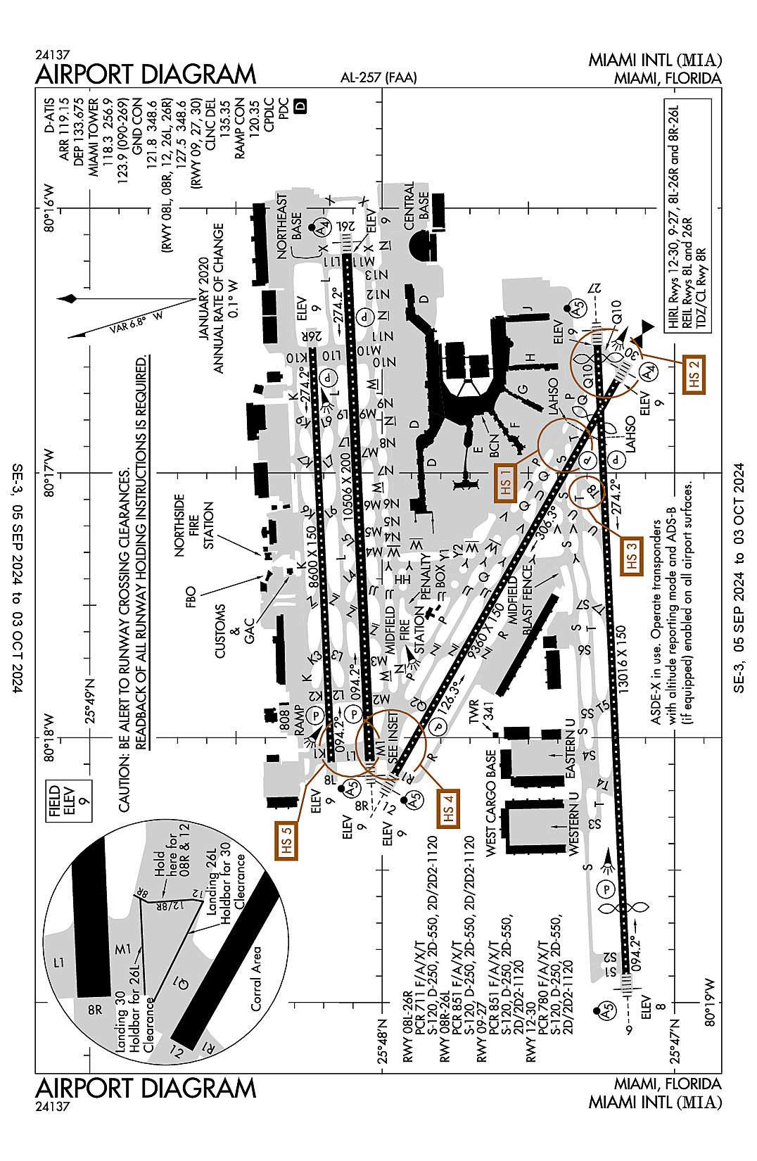
Miami, Florida
Miami International
ICAO Identifier KMIA
Miami, FL
Miami Intl
ICAO Identifier KMIA
AD 2.2 Aerodrome Geographical and Administrative Data
2.2.1 Reference Point: 25-47-43.3N / 80-17-24.417W
2.2.2 From City: 8 miles NW of MIAMI, FL
2.2.3 Elevation: 9.3 ft
2.2.5 Magnetic Variation: 5W (2000)
2.2.6 Airport Contact: RALPH CUTIE
MIAMI-DADE AVIATION DEPARTMENT
MIAMI, FL 33102 (305-876-7038)
2.2.7 Traffic: IFR/VFR
AD 2.3 Attendance Schedule
2.3.1 All Months, All Days, All Hours
AD 2.4 Handling Services and Facilities
2.4.1 Cargo Handling Facilities: YES
2.4.2 Fuel Types: 100 A
2.4.5 Hangar Space: YES
2.4.6 Repair Facilities: MAJOR
AD 2.6 Rescue and Firefighting Services
2.6.1 Aerodrome Category: Class-I certified on 5/1/1973
2.6.2 Rescue and Firefighting Services: ARFF Index-E
AD 2.12 Runway Physical Characteristics
2.12.1 Designation: 26R
2.12.2 True Bearing: 267
2.12.3 True Dimensions: 8600 ft x 150 ft
2.12.4 PCN:
2.12.5 Coordinates: 25-48-14.3204N / 80-16-31.5499W
2.12.6 Threshold Elevation: 8.8
2.12.6 Touchdown Zone Elevation: 9
2.12.1 Designation: 08L
2.12.2 True Bearing: 87
2.12.3 True Dimensions: 8600 ft x 150 ft
2.12.4 PCN:
2.12.5 Coordinates: 25-48-10.432N / 80-18-05.5508W
2.12.6 Threshold Elevation: 8.9
2.12.6 Touchdown Zone Elevation: 9.1
2.12.1 Designation: 08R
2.12.2 True Bearing: 87
2.12.3 True Dimensions: 10506 ft x 200 ft
2.12.4 PCN:
2.12.5 Coordinates: 25-48-02.5177N / 80-18-05.1588W
2.12.6 Threshold Elevation: 8.5
2.12.6 Touchdown Zone Elevation: 9.1
2.12.1 Designation: 26L
2.12.2 True Bearing: 267
2.12.3 True Dimensions: 10506 ft x 200 ft
2.12.4 PCN:
2.12.5 Coordinates: 25-48-07.2652N / 80-16-10.3282W
2.12.6 Threshold Elevation: 8.9
2.12.6 Touchdown Zone Elevation: 9
2.12.1 Designation: 09
2.12.2 True Bearing: 87
2.12.3 True Dimensions: 13016 ft x 150 ft
2.12.4 PCN:
2.12.5 Coordinates: 25-47-09.9421N / 80-18-53.4173W
2.12.6 Threshold Elevation: 8.1
2.12.6 Touchdown Zone Elevation: 8.2
2.12.1 Designation: 27
2.12.2 True Bearing: 267
2.12.3 True Dimensions: 13016 ft x 150 ft
2.12.4 PCN:
2.12.5 Coordinates: 25-47-15.8328N / 80-16-31.1711W
2.12.6 Threshold Elevation: 9
2.12.6 Touchdown Zone Elevation: 9.1
2.12.1 Designation: 30
2.12.2 True Bearing: 299
2.12.3 True Dimensions: 9360 ft x 150 ft
2.12.4 PCN:
2.12.5 Coordinates: 25-47-11.8224N / 80-16-39.0805W
2.12.6 Threshold Elevation: 8.7
2.12.6 Touchdown Zone Elevation: 9.3
2.12.1 Designation: 12
2.12.2 True Bearing: 119
2.12.3 True Dimensions: 9360 ft x 150 ft
2.12.4 PCN:
2.12.5 Coordinates: 25-47-57.4262N / 80-18-08.2439W
2.12.6 Threshold Elevation: 9.1
2.12.6 Touchdown Zone Elevation: 9.2
AD 2.13 Declared Distances
2.13.1 Designation: 26R
2.13.2 Take-off Run Available: 8600
2.13.3 Take-off Distance Available: 8600
2.13.4 Accelerate-Stop Distance Available: 8600
2.13.5 Landing Distance Available: 8600
2.13.1 Designation: 08L
2.13.2 Take-off Run Available: 8600
2.13.3 Take-off Distance Available: 8600
2.13.4 Accelerate-Stop Distance Available: 8600
2.13.5 Landing Distance Available: 8600
2.13.1 Designation: 08R
2.13.2 Take-off Run Available: 10506
2.13.3 Take-off Distance Available: 10506
2.13.4 Accelerate-Stop Distance Available: 10506
2.13.5 Landing Distance Available: 10506
2.13.1 Designation: 26L
2.13.2 Take-off Run Available: 10506
2.13.3 Take-off Distance Available: 10506
2.13.4 Accelerate-Stop Distance Available: 10220
2.13.5 Landing Distance Available: 10220
2.13.1 Designation: 09
2.13.2 Take-off Run Available: 13016
2.13.3 Take-off Distance Available: 13016
2.13.4 Accelerate-Stop Distance Available: 12755
2.13.5 Landing Distance Available: 11397
2.13.1 Designation: 27
2.13.2 Take-off Run Available: 13016
2.13.3 Take-off Distance Available: 13016
2.13.4 Accelerate-Stop Distance Available: 13016
2.13.5 Landing Distance Available: 12755
2.13.1 Designation: 30
2.13.2 Take-off Run Available: 9355
2.13.3 Take-off Distance Available: 9355
2.13.4 Accelerate-Stop Distance Available: 8853
2.13.5 Landing Distance Available: 7913
2.13.1 Designation: 12
2.13.2 Take-off Run Available: 9355
2.13.3 Take-off Distance Available: 9355
2.13.4 Accelerate-Stop Distance Available: 8579
2.13.5 Landing Distance Available: 8579
AD 2.14 Approach and Runway Lighting
2.14.1 Designation: 26R
2.14.2 Approach Lighting System:
2.14.4 Visual Approach Slope Indicator System: P4L
2.14.1 Designation: 08L
2.14.2 Approach Lighting System:
2.14.4 Visual Approach Slope Indicator System: P4L
2.14.1 Designation: 08R
2.14.2 Approach Lighting System: MALSR
2.14.4 Visual Approach Slope Indicator System: P4L
2.14.1 Designation: 26L
2.14.2 Approach Lighting System: MALSF
2.14.4 Visual Approach Slope Indicator System: P4L
2.14.1 Designation: 09
2.14.2 Approach Lighting System: MALSR
2.14.4 Visual Approach Slope Indicator System: P4L
2.14.1 Designation: 27
2.14.2 Approach Lighting System: MALSR
2.14.4 Visual Approach Slope Indicator System: P4L
2.14.1 Designation: 30
2.14.2 Approach Lighting System: MALS
2.14.4 Visual Approach Slope Indicator System: P4L
2.14.1 Designation: 12
2.14.2 Approach Lighting System: MALSR
2.14.4 Visual Approach Slope Indicator System: P4R
AD 2.18 Air Traffic Services Communication Facilities
2.18.1 Service Designation: ALTNN DP
2.18.3 Channel: 119.45
2.18.5 Hours of Operation: 24
2.18.1 Service Designation: ALTNN DP
2.18.3 Channel: 290.325
2.18.5 Hours of Operation: 24
2.18.1 Service Designation: ANNEY STAR
2.18.3 Channel: 125.75
2.18.5 Hours of Operation: 24
2.18.1 Service Designation: ANNEY STAR
2.18.3 Channel: 322.3
2.18.5 Hours of Operation: 24
2.18.1 Service Designation: APCH/P DEP/P (090-269)
2.18.3 Channel: 120.5
2.18.5 Hours of Operation: 24
2.18.1 Service Designation: APCH/P DEP/P (270-089)
2.18.3 Channel: 125.75
2.18.5 Hours of Operation: 24
2.18.1 Service Designation: APCH/P DEP/P (090-269)
2.18.3 Channel: 379.9
2.18.5 Hours of Operation: 24
2.18.1 Service Designation: APCH/P IC (270-089)
2.18.3 Channel: 124.85
2.18.5 Hours of Operation: 24
2.18.1 Service Designation: APCH/P IC (270-089)
2.18.3 Channel: 322.3
2.18.5 Hours of Operation: 24
2.18.1 Service Designation: APCH/S
2.18.3 Channel: 125.75
2.18.5 Hours of Operation: 24
2.18.1 Service Designation: APCH/S (270-089)
2.18.3 Channel: 263.025
2.18.5 Hours of Operation: 24
2.18.1 Service Designation: BLUFI STAR
2.18.3 Channel: 125.75
2.18.5 Hours of Operation: 24
2.18.1 Service Designation: BLUFI STAR
2.18.3 Channel: 322.3
2.18.5 Hours of Operation: 24
2.18.1 Service Designation: BNFSH STAR
2.18.3 Channel: 124.85
2.18.5 Hours of Operation: 24
2.18.1 Service Designation: BNFSH STAR
2.18.3 Channel: 263.025
2.18.5 Hours of Operation: 24
2.18.1 Service Designation: BNGOS DP
2.18.3 Channel: 119.45
2.18.5 Hours of Operation: 24
2.18.1 Service Designation: BNGOS DP
2.18.3 Channel: 290.325
2.18.5 Hours of Operation: 24
2.18.1 Service Designation: CD/P
2.18.3 Channel: 135.35
2.18.5 Hours of Operation: 24
2.18.1 Service Designation: CLASS B (090-269)
2.18.3 Channel: 120.5
2.18.5 Hours of Operation: 24
2.18.1 Service Designation: CLASS B (270-089)
2.18.3 Channel: 125.75
2.18.5 Hours of Operation: 24
2.18.1 Service Designation: CLASS B (270-089)
2.18.3 Channel: 322.3
2.18.5 Hours of Operation: 24
2.18.1 Service Designation: CLASS B (090-269)
2.18.3 Channel: 379.9
2.18.5 Hours of Operation: 24
2.18.1 Service Designation: CSTAL STAR
2.18.3 Channel: 124.85
2.18.5 Hours of Operation: 24
2.18.1 Service Designation: CSTAL STAR
2.18.3 Channel: 263.025
2.18.5 Hours of Operation: 24
2.18.1 Service Designation: D-ATIS (ARRIVAL)
2.18.3 Channel: 119.15
2.18.5 Hours of Operation: 24
2.18.1 Service Designation: D-ATIS (DEPART)
2.18.3 Channel: 133.675
2.18.5 Hours of Operation: 24
2.18.1 Service Designation: DEP/P (090-269)
2.18.3 Channel: 125.5
2.18.5 Hours of Operation: 24
2.18.1 Service Designation: DEP/P (270-089)
2.18.3 Channel: 290.325
2.18.5 Hours of Operation: 24
2.18.1 Service Designation: DEP/P (090-269)
2.18.3 Channel: 354.1
2.18.5 Hours of Operation: 24
2.18.1 Service Designation: DEP/P IC (270-089)
2.18.3 Channel: 119.45
2.18.5 Hours of Operation: 24
2.18.1 Service Designation: DORRL DP
2.18.3 Channel: 119.45
2.18.5 Hours of Operation: 24
2.18.1 Service Designation: DORRL DP
2.18.3 Channel: 290.325
2.18.5 Hours of Operation: 24
2.18.1 Service Designation: DVALL STAR
2.18.3 Channel: 120.5
2.18.5 Hours of Operation: 24
2.18.1 Service Designation: DVALL STAR
2.18.3 Channel: 350.225
2.18.5 Hours of Operation: 24
2.18.1 Service Designation: EMERG
2.18.3 Channel: 121.5
2.18.5 Hours of Operation:
2.18.1 Service Designation: FLMGO DP
2.18.3 Channel: 119.45
2.18.5 Hours of Operation: 24
2.18.1 Service Designation: FLMGO DP
2.18.3 Channel: 290.325
2.18.5 Hours of Operation: 24
2.18.1 Service Designation: FOLZZ DP
2.18.3 Channel: 119.45
2.18.5 Hours of Operation: 24
2.18.1 Service Designation: FOLZZ DP
2.18.3 Channel: 290.325
2.18.5 Hours of Operation: 24
2.18.1 Service Designation: FOWEE STAR
2.18.3 Channel: 120.5
2.18.5 Hours of Operation: 24
2.18.1 Service Designation: FOWEE STAR
2.18.3 Channel: 124.85
2.18.5 Hours of Operation: 24
2.18.1 Service Designation: FOWEE STAR
2.18.3 Channel: 350.225
2.18.5 Hours of Operation: 24
2.18.1 Service Designation: FROGZ STAR
2.18.3 Channel: 120.5
2.18.5 Hours of Operation: 24
2.18.1 Service Designation: FROGZ STAR
2.18.3 Channel: 350.225
2.18.5 Hours of Operation: 24
2.18.1 Service Designation: GLADZ DP (DEPARTING EAST)
2.18.3 Channel: 119.45
2.18.5 Hours of Operation: 24
2.18.1 Service Designation: GLADZ DP (DEPARTING WEST)
2.18.3 Channel: 125.5
2.18.5 Hours of Operation: 24
2.18.1 Service Designation: GLADZ DP (DEPARTING EAST)
2.18.3 Channel: 290.325
2.18.5 Hours of Operation: 24
2.18.1 Service Designation: GLADZ DP (DEPARTING WEST)
2.18.3 Channel: 354.1
2.18.5 Hours of Operation: 24
2.18.1 Service Designation: GND/P IC (RWY 08L/26R, 08R/26L, 12)
2.18.3 Channel: 121.8
2.18.5 Hours of Operation: 24
2.18.1 Service Designation: GND/P IC (RWY 09/27, 30)
2.18.3 Channel: 127.5
2.18.5 Hours of Operation: 24
2.18.1 Service Designation: GND/P IC
2.18.3 Channel: 348.6
2.18.5 Hours of Operation: 24
2.18.1 Service Designation: GWAVA DP
2.18.3 Channel: 125.5
2.18.5 Hours of Operation: 24
2.18.1 Service Designation: GWAVA DP
2.18.3 Channel: 354.1
2.18.5 Hours of Operation: 24
2.18.1 Service Designation: HURCN DP
2.18.3 Channel: 119.45
2.18.5 Hours of Operation: 24
2.18.1 Service Designation: HURCN DP
2.18.3 Channel: 290.325
2.18.5 Hours of Operation: 24
2.18.1 Service Designation: HUSIL DP
2.18.3 Channel: 119.45
2.18.5 Hours of Operation: 24
2.18.1 Service Designation: HUSIL DP
2.18.3 Channel: 290.325
2.18.5 Hours of Operation: 24
2.18.1 Service Designation: KLADA DP
2.18.3 Channel: 125.5
2.18.5 Hours of Operation: 24
2.18.1 Service Designation: KLADA DP
2.18.3 Channel: 354.1
2.18.5 Hours of Operation: 24
2.18.1 Service Designation: LCL/P (090-269)
2.18.3 Channel: 123.9
2.18.5 Hours of Operation: 24
2.18.1 Service Designation: LCL/P IC (270-089)
2.18.3 Channel: 118.3
2.18.5 Hours of Operation: 24
2.18.1 Service Designation: LCL/P IC
2.18.3 Channel: 256.9
2.18.5 Hours of Operation: 24
2.18.1 Service Designation: LIFRR DP
2.18.3 Channel: 119.45
2.18.5 Hours of Operation: 24
2.18.1 Service Designation: LIFRR DP
2.18.3 Channel: 290.325
2.18.5 Hours of Operation: 24
2.18.1 Service Designation: LUUCE STAR (9000 FT)
2.18.3 Channel: 126.05
2.18.5 Hours of Operation: 24
2.18.1 Service Designation: LUUCE STAR (7000 FT)
2.18.3 Channel: 133.775
2.18.5 Hours of Operation: 24
2.18.1 Service Designation: LUUCE STAR (9000 FT)
2.18.3 Channel: 251.1
2.18.5 Hours of Operation: 24
2.18.1 Service Designation: LUUCE STAR (7000 FT)
2.18.3 Channel: 371.9
2.18.5 Hours of Operation: 24
2.18.1 Service Designation: MAYNR DP
2.18.3 Channel: 125.5
2.18.5 Hours of Operation: 24
2.18.1 Service Designation: MAYNR DP
2.18.3 Channel: 354.1
2.18.5 Hours of Operation: 24
2.18.1 Service Designation: MIAMI DP (ALTNN, BEECH, BNGOS, DORRL, FLMGO, HURCN, FOLZZ, ZFP)
2.18.3 Channel: 119.45
2.18.5 Hours of Operation: 24
2.18.1 Service Designation: MIAMI DP (GWAVA, KETLL, MAYNR TRANSITIONS)
2.18.3 Channel: 125.5
2.18.5 Hours of Operation: 24
2.18.1 Service Designation: MIAMI DP (ALTNN, BEECH, BNGOS, DORRL, FLMGO, HURCN, FOLZZ, ZFP)
2.18.3 Channel: 290.325
2.18.5 Hours of Operation: 24
2.18.1 Service Designation: MIAMI DP (GWAVA, KETLL, MAYNR TRANSITIONS)
2.18.3 Channel: 354.1
2.18.5 Hours of Operation: 24
2.18.1 Service Designation: NNOCE DP
2.18.3 Channel: 125.5
2.18.5 Hours of Operation: 24
2.18.1 Service Designation: NNOCE DP
2.18.3 Channel: 354.1
2.18.5 Hours of Operation: 24
2.18.1 Service Designation: PALMZ STAR
2.18.3 Channel: 120.5
2.18.5 Hours of Operation: 24
2.18.1 Service Designation: PALMZ STAR
2.18.3 Channel: 350.225
2.18.5 Hours of Operation: 24
2.18.1 Service Designation: RAMP CTL
2.18.3 Channel: 120.35
2.18.5 Hours of Operation: 24
2.18.1 Service Designation: RTIS (120-300 WITHIN 25 NM)
2.18.3 Channel: 125.25
2.18.5 Hours of Operation: 24
2.18.1 Service Designation: SNDBR STAR
2.18.3 Channel: 120.5
2.18.5 Hours of Operation: 24
2.18.1 Service Designation: SNDBR STAR
2.18.3 Channel: 350.225
2.18.5 Hours of Operation: 24
2.18.1 Service Designation: TARPN STAR (9000 FT)
2.18.3 Channel: 126.05
2.18.5 Hours of Operation: 24
2.18.1 Service Designation: TARPN STAR (7000 FT)
2.18.3 Channel: 133.775
2.18.5 Hours of Operation: 24
2.18.1 Service Designation: TARPN STAR (9000 FT)
2.18.3 Channel: 251.1
2.18.5 Hours of Operation: 24
2.18.1 Service Designation: TARPN STAR (7000 FT)
2.18.3 Channel: 371.9
2.18.5 Hours of Operation: 24
2.18.1 Service Designation: VIICE STAR
2.18.3 Channel: 120.5
2.18.5 Hours of Operation: 24
2.18.1 Service Designation: VIICE STAR
2.18.3 Channel: 350.225
2.18.5 Hours of Operation: 24
AD 2.19 Radio Navigation and Landing Aids
2.19.1 ILS Type: DME for runway 08L. Magnetic variation: 5W
2.19.2 ILS Identification: ROY
2.19.5 Coordinates: 25-48-16.3597N / 80-16-18.3104W
2.19.6 Site Elevation: 20.1 ft
2.19.1 ILS Type: Localizer for runway 08L. Magnetic variation: 5W
2.19.2 ILS Identification: ROY
2.19.5 Coordinates: 25-48-14.865N / 80-16-18.3941W
2.19.6 Site Elevation: 6.8 ft
2.19.1 ILS Type: DME for runway 26R. Magnetic variation: 5W
2.19.2 ILS Identification: CNV
2.19.5 Coordinates: 25-48-07.1241N / 80-18-16.4684W
2.19.6 Site Elevation: 20.3 ft
2.19.1 ILS Type: Localizer for runway 26R. Magnetic variation: 5W
2.19.2 ILS Identification: CNV
2.19.5 Coordinates: 25-48-09.969N / 80-18-16.6983W
2.19.6 Site Elevation: 7.4 ft
2.19.1 ILS Type: DME for runway 08R. Magnetic variation: 5W
2.19.2 ILS Identification: MFA
2.19.5 Coordinates: 25-48-05.0878N / 80-16-00.575W
2.19.6 Site Elevation: 15.6 ft
2.19.1 ILS Type: Glide Slop for runway 08R. Magnetic variation: 5W
2.19.2 ILS Identification: MFA
2.19.5 Coordinates: 25-48-06.1715N / 80-17-54.807W
2.19.6 Site Elevation: 5 ft
2.19.1 ILS Type: Localizer for runway 08R. Magnetic variation: 5W
2.19.2 ILS Identification: MFA
2.19.5 Coordinates: 25-48-07.688N / 80-16-00.0426W
2.19.6 Site Elevation: 6.3 ft
2.19.1 ILS Type: DME for runway 26L. Magnetic variation: 5W
2.19.2 ILS Identification: VIN
2.19.5 Coordinates: 25-48-05.8074N / 80-18-14.9415W
2.19.6 Site Elevation: 14.3 ft
2.19.1 ILS Type: Glide Slop for runway 26L. Magnetic variation: 5W
2.19.2 ILS Identification: VIN
2.19.5 Coordinates: 25-48-09.7347N / 80-16-22.5043W
2.19.6 Site Elevation: 5.9 ft
2.19.1 ILS Type: Localizer for runway 26L. Magnetic variation: 5W
2.19.2 ILS Identification: VIN
2.19.5 Coordinates: 25-48-02.1576N / 80-18-13.7966W
2.19.6 Site Elevation: 7.6 ft
2.19.1 ILS Type: DME for runway 09. Magnetic variation: 5W
2.19.2 ILS Identification: BUL
2.19.5 Coordinates: 25-47-15.8249N / 80-16-17.2451W
2.19.6 Site Elevation: 20.1 ft
2.19.1 ILS Type: Glide Slop for runway 09. Magnetic variation: 5W
2.19.2 ILS Identification: BUL
2.19.5 Coordinates: 25-47-07.8388N / 80-18-26.7053W
2.19.6 Site Elevation: 7.5 ft
2.19.1 ILS Type: Localizer for runway 09. Magnetic variation: 5W
2.19.2 ILS Identification: BUL
2.19.5 Coordinates: 25-47-16.4165N / 80-16-17.1006W
2.19.6 Site Elevation: 18.4 ft
2.19.1 ILS Type: Glide Slop for runway 27. Magnetic variation: 5W
2.19.2 ILS Identification: MIA
2.19.5 Coordinates: 25-47-11.7269N / 80-16-45.3981W
2.19.6 Site Elevation: 4.7 ft
2.19.1 ILS Type: Localizer for runway 27. Magnetic variation: 5W
2.19.2 ILS Identification: MIA
2.19.5 Coordinates: 25-47-09.3891N / 80-19-06.6406W
2.19.6 Site Elevation: 7.1 ft
2.19.1 ILS Type: DME for runway 12. Magnetic variation: 5W
2.19.2 ILS Identification: GEM
2.19.5 Coordinates: 25-47-11.2767N / 80-16-32.4152W
2.19.6 Site Elevation: 15.9 ft
2.19.1 ILS Type: Glide Slop for runway 12. Magnetic variation: 5W
2.19.2 ILS Identification: GEM
2.19.5 Coordinates: 25-47-50.78N / 80-17-58.58W
2.19.6 Site Elevation: 7 ft
2.19.1 ILS Type: Localizer for runway 12. Magnetic variation: 5W
2.19.2 ILS Identification: GEM
2.19.5 Coordinates: 25-47-09.6403N / 80-16-34.8108W
2.19.6 Site Elevation: 8.3 ft
2.19.1 ILS Type: DME for runway 30. Magnetic variation: 5W
2.19.2 ILS Identification: DCX
2.19.5 Coordinates: 25-47-57.7789N / 80-18-14.5127W
2.19.6 Site Elevation: 14.7 ft
2.19.1 ILS Type: Glide Slop for runway 30. Magnetic variation: 5W
2.19.2 ILS Identification: DCX
2.19.5 Coordinates: 25-47-17.643N / 80-16-59.572W
2.19.6 Site Elevation: 7.1 ft
2.19.1 ILS Type: Localizer for runway 30. Magnetic variation: 5W
2.19.2 ILS Identification: DCX
2.19.5 Coordinates: 25-47-59.8764N / 80-18-13.0372W
2.19.6 Site Elevation: 8.9 ft
General Remarks:
ACFT WITH A WINGSPAN GTR THAN 171 FT ARE PROHIBITED FM TXG ON TWY P E OF TWY U, EXCEPT ADG VI ACFT COMPLYING WITH MIA ADG VI OPERATIONAL PLAN WHEN ADJ AIRSIDE SVC ROAD IS CLSD TO TRAFFIC.
ALL MEDICAL EMERGENCIES ARRIVALS, WITH THE EXCEPTION OF AIR AMBULANCE FLIGHTS, MUST SECURE DOORS UNTIL ARFF IS ON SCENE.
ACFT WITH A WINGSPAN GTR THAN 171 FT ARE PROHIBITED FM TXG ON TWY P E OF TWY U, EXCEPT ADG VI ACFT COMPLYING WITH MIA ADG VI OPERATIONAL PLAN WHEN ADJ AIRSIDE SVC ROAD IS CLSD TO TFC.
ALL TBJT ACFT ARE REQD TO USE DSNT NOISE ABATEMENT DEP PROFILE (NADP-2) FROM ALL RWYS.
AIRPORT MANAGER: 305-876-7038.
US CBP AND EAPIS AVBL.
ALL DIVERSION CTC FREQ 130.5 UPON ARR.
PPR 3 HRS PRIOR TO ALL ARRIVALS ON THE GENERAL AVIATION CENTER (GAC) RAMP 305-876-7550 CTC RAMP CONTROL UPON ARRIVAL ON FREQUENCY 131.600. ACFT WITH WINGSPAN GREATER THAN 78 FT ARE PROHIBITED FROM ENTERING THE GAC RAMP.
AIRPORT OPS 305-876-7550.
CLSD NON ENG ACFT.
RWY 08L-26R CLSD 0300-1200Z++ WHEN RWY 08R-26L AND RWY 09-27 ARE IN USE.
CLOSE-IN NOISE ABATEMENT DEP PROFILE TO BE USED BY A319/320/321, A330-200/300, B727-200, B737-800/900, B767-200/300/400/700, B747-800, B777-300/77L/77W, AND MD-11. DSNT NOISE ABATEMENT DEP PROFILE TO BE USED BY ALL OTHER TURBOJET ACFT.
RWY 12-30 CLSD 0300-1200Z++ WHEN RWY 08R-26L AND RWY 09-27 ARE IN USE.
BIRDS ON & INVOF ARPT.
PPR FOR INBOUND MILITARY FLIGHTS 100 NM ON FREQ 130.5.
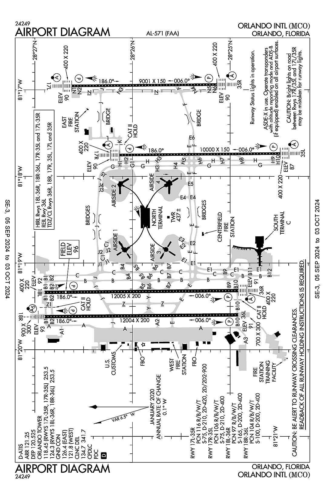
Orlando, Florida
Orlando International
ICAO Identifier KMCO
Orlando, FL
Orlando Intl
ICAO Identifier KMCO
AD 2.2 Aerodrome Geographical and Administrative Data
2.2.1 Reference Point: 28-25-45.8N / 81-18-32.4W
2.2.2 From City: 6 miles SE of ORLANDO, FL
2.2.3 Elevation: 96.4 ft
2.2.5 Magnetic Variation: 6W (2015)
2.2.6 Airport Contact: KEVIN J. THIBAULT, P.E.
1 JEFF FUQUA BLVD
ORLANDO, FL 32827 (407-825-7445)
2.2.7 Traffic: IFR/VFR
AD 2.3 Attendance Schedule
2.3.1 All Months, All Days, All Hours
AD 2.4 Handling Services and Facilities
2.4.1 Cargo Handling Facilities: YES
2.4.2 Fuel Types: 100LL A
2.4.5 Hangar Space: YES
2.4.6 Repair Facilities: MINOR
AD 2.6 Rescue and Firefighting Services
2.6.1 Aerodrome Category: Class-I certified on 5/21/1973
2.6.2 Rescue and Firefighting Services: ARFF Index-E
AD 2.12 Runway Physical Characteristics
2.12.1 Designation: 35R
2.12.2 True Bearing: 359
2.12.3 True Dimensions: 9001 ft x 150 ft
2.12.4 PCN: 116 R/B/W/T
2.12.5 Coordinates: 28-25-08.1974N / 81-16-56.3802W
2.12.6 Threshold Elevation: 89.7
2.12.6 Touchdown Zone Elevation: 89.8
2.12.1 Designation: 17L
2.12.2 True Bearing: 179
2.12.3 True Dimensions: 9001 ft x 150 ft
2.12.4 PCN: 116 R/B/W/T
2.12.5 Coordinates: 28-26-37.308N / 81-16-57.2924W
2.12.6 Threshold Elevation: 89.7
2.12.6 Touchdown Zone Elevation: 89.9
2.12.1 Designation: 17R
2.12.2 True Bearing: 179
2.12.3 True Dimensions: 10000 ft x 150 ft
2.12.4 PCN: 106 R/B/W/T
2.12.5 Coordinates: 28-26-08.2029N / 81-17-45.1656W
2.12.6 Threshold Elevation: 90.1
2.12.6 Touchdown Zone Elevation: 90.2
2.12.1 Designation: 35L
2.12.2 True Bearing: 359
2.12.3 True Dimensions: 10000 ft x 150 ft
2.12.4 PCN: 106 R/B/W/T
2.12.5 Coordinates: 28-24-29.1952N / 81-17-44.1335W
2.12.6 Threshold Elevation: 86.7
2.12.6 Touchdown Zone Elevation: 88.3
2.12.1 Designation: 36R
2.12.2 True Bearing: 359
2.12.3 True Dimensions: 12005 ft x 200 ft
2.12.4 PCN: 97 R/B/W/T
2.12.5 Coordinates: 28-24-55.1469N / 81-19-19.0358W
2.12.6 Threshold Elevation: 91
2.12.6 Touchdown Zone Elevation: 92.3
2.12.1 Designation: 18L
2.12.2 True Bearing: 179
2.12.3 True Dimensions: 12005 ft x 200 ft
2.12.4 PCN: 97 R/B/W/T
2.12.5 Coordinates: 28-26-54.0038N / 81-19-20.3022W
2.12.6 Threshold Elevation: 92.4
2.12.6 Touchdown Zone Elevation: 96.4
2.12.1 Designation: 18R
2.12.2 True Bearing: 179
2.12.3 True Dimensions: 12004 ft x 200 ft
2.12.4 PCN: 104 R/B/W/T
2.12.5 Coordinates: 28-26-53.8569N / 81-19-37.1091W
2.12.6 Threshold Elevation: 92.5
2.12.6 Touchdown Zone Elevation: 93.5
2.12.1 Designation: 36L
2.12.2 True Bearing: 359
2.12.3 True Dimensions: 12004 ft x 200 ft
2.12.4 PCN: 104 R/B/W/T
2.12.5 Coordinates: 28-24-55.007N / 81-19-35.8294W
2.12.6 Threshold Elevation: 91.1
2.12.6 Touchdown Zone Elevation: 92.6
AD 2.13 Declared Distances
2.13.1 Designation: 35R
2.13.2 Take-off Run Available: 9001
2.13.3 Take-off Distance Available: 9001
2.13.4 Accelerate-Stop Distance Available: 9001
2.13.5 Landing Distance Available: 9001
2.13.1 Designation: 17L
2.13.2 Take-off Run Available: 9001
2.13.3 Take-off Distance Available: 9001
2.13.4 Accelerate-Stop Distance Available: 9001
2.13.5 Landing Distance Available: 9001
2.13.1 Designation: 17R
2.13.2 Take-off Run Available: 10000
2.13.3 Take-off Distance Available: 10000
2.13.4 Accelerate-Stop Distance Available: 10000
2.13.5 Landing Distance Available: 10000
2.13.1 Designation: 35L
2.13.2 Take-off Run Available: 10000
2.13.3 Take-off Distance Available: 10000
2.13.4 Accelerate-Stop Distance Available: 10000
2.13.5 Landing Distance Available: 10000
2.13.1 Designation: 36R
2.13.2 Take-off Run Available: 12005
2.13.3 Take-off Distance Available: 12005
2.13.4 Accelerate-Stop Distance Available: 11601
2.13.5 Landing Distance Available: 11601
2.13.1 Designation: 18L
2.13.2 Take-off Run Available: 12005
2.13.3 Take-off Distance Available: 12005
2.13.4 Accelerate-Stop Distance Available: 12005
2.13.5 Landing Distance Available: 12005
2.13.1 Designation: 18R
2.13.2 Take-off Run Available: 12004
2.13.3 Take-off Distance Available: 12004
2.13.4 Accelerate-Stop Distance Available: 12004
2.13.5 Landing Distance Available: 12004
2.13.1 Designation: 36L
2.13.2 Take-off Run Available: 12004
2.13.3 Take-off Distance Available: 12004
2.13.4 Accelerate-Stop Distance Available: 11621
2.13.5 Landing Distance Available: 11621
AD 2.14 Approach and Runway Lighting
2.14.1 Designation: 35R
2.14.2 Approach Lighting System: ALSF2
2.14.4 Visual Approach Slope Indicator System: P4R
2.14.1 Designation: 17L
2.14.2 Approach Lighting System: ALSF2
2.14.4 Visual Approach Slope Indicator System: P4L
2.14.1 Designation: 17R
2.14.2 Approach Lighting System: ALSF2
2.14.4 Visual Approach Slope Indicator System: P4L
2.14.1 Designation: 35L
2.14.2 Approach Lighting System: ALSF2
2.14.4 Visual Approach Slope Indicator System: P4R
2.14.1 Designation: 36R
2.14.2 Approach Lighting System: ALSF2
2.14.4 Visual Approach Slope Indicator System: P4L
2.14.1 Designation: 18L
2.14.2 Approach Lighting System:
2.14.4 Visual Approach Slope Indicator System: P4L
2.14.1 Designation: 18R
2.14.2 Approach Lighting System: MALSR
2.14.4 Visual Approach Slope Indicator System: P4L
2.14.1 Designation: 36L
2.14.2 Approach Lighting System:
2.14.4 Visual Approach Slope Indicator System: P4L
AD 2.18 Air Traffic Services Communication Facilities
2.18.1 Service Designation: AR OPS
2.18.3 Channel: 41.5
2.18.5 Hours of Operation:
2.18.1 Service Designation: AR OPS
2.18.3 Channel: 148.8
2.18.5 Hours of Operation:
2.18.1 Service Designation: CD/P
2.18.3 Channel: 134.7
2.18.5 Hours of Operation: 24
2.18.1 Service Designation: CD/P
2.18.3 Channel: 341.7
2.18.5 Hours of Operation: 24
2.18.1 Service Designation: D-ATIS (DEP)
2.18.3 Channel: 120.525
2.18.5 Hours of Operation: 24
2.18.1 Service Designation: D-ATIS (ARR)
2.18.3 Channel: 121.25
2.18.5 Hours of Operation: 24
2.18.1 Service Designation: EMERG
2.18.3 Channel: 121.5
2.18.5 Hours of Operation:
2.18.1 Service Designation: EMERG
2.18.3 Channel: 243
2.18.5 Hours of Operation:
2.18.1 Service Designation: GND/P (WEST)
2.18.3 Channel: 121.8
2.18.5 Hours of Operation: 24
2.18.1 Service Designation: GND/P (EAST)
2.18.3 Channel: 126.4
2.18.5 Hours of Operation: 24
2.18.1 Service Designation: LCL/P (RWY 17L/35R, 17R/35L)
2.18.3 Channel: 118.45
2.18.5 Hours of Operation: 24
2.18.1 Service Designation: LCL/P (RWY 18L/36R, 18R/36L)
2.18.3 Channel: 124.3
2.18.5 Hours of Operation: 24
2.18.1 Service Designation: LCL/P
2.18.3 Channel: 253.5
2.18.5 Hours of Operation: 24
AD 2.19 Radio Navigation and Landing Aids
2.19.1 ILS Type: DME for runway 17L. Magnetic variation: 6W
2.19.2 ILS Identification: ARK
2.19.5 Coordinates: 28-24-57.9921N / 81-16-51.737W
2.19.6 Site Elevation: 97 ft
2.19.1 ILS Type: Glide Slop for runway 17L. Magnetic variation: 6W
2.19.2 ILS Identification: ARK
2.19.5 Coordinates: 28-26-27.0479N / 81-16-52.5933W
2.19.6 Site Elevation: 94.4 ft
2.19.1 ILS Type: Localizer for runway 17L. Magnetic variation: 6W
2.19.2 ILS Identification: ARK
2.19.5 Coordinates: 28-24-57.8892N / 81-16-56.2728W
2.19.6 Site Elevation: 89.1 ft
2.19.1 ILS Type: DME for runway 35R. Magnetic variation: 6W
2.19.2 ILS Identification: CER
2.19.5 Coordinates: 28-26-48.2377N / 81-16-52.8447W
2.19.6 Site Elevation: 98.3 ft
2.19.1 ILS Type: Glide Slop for runway 35R. Magnetic variation: 6W
2.19.2 ILS Identification: CER
2.19.5 Coordinates: 28-25-18.6301N / 81-16-51.8726W
2.19.6 Site Elevation: 87.3 ft
2.19.1 ILS Type: Localizer for runway 35R. Magnetic variation: 6W
2.19.2 ILS Identification: CER
2.19.5 Coordinates: 28-26-47.6103N / 81-16-57.3979W
2.19.6 Site Elevation: 89.6 ft
2.19.1 ILS Type: DME for runway 17R. Magnetic variation: 6W
2.19.2 ILS Identification: DIZ
2.19.5 Coordinates: 28-24-18.9549N / 81-17-47.0755W
2.19.6 Site Elevation: 86.4 ft
2.19.1 ILS Type: Glide Slop for runway 17R. Magnetic variation: 6W
2.19.2 ILS Identification: DIZ
2.19.5 Coordinates: 28-25-57.8375N / 81-17-40.5783W
2.19.6 Site Elevation: 92.7 ft
2.19.1 ILS Type: Localizer for runway 17R. Magnetic variation: 6W
2.19.2 ILS Identification: DIZ
2.19.5 Coordinates: 28-24-18.7729N / 81-17-44.0255W
2.19.6 Site Elevation: 81.6 ft
2.19.1 ILS Type: DME for runway 35L. Magnetic variation: 6W
2.19.2 ILS Identification: DDO
2.19.5 Coordinates: 28-26-18.3948N / 81-17-48.1528W
2.19.6 Site Elevation: 95.5 ft
2.19.1 ILS Type: Glide Slop for runway 35L. Magnetic variation: 6W
2.19.2 ILS Identification: DDO
2.19.5 Coordinates: 28-24-39.5307N / 81-17-39.7618W
2.19.6 Site Elevation: 83.7 ft
2.19.1 ILS Type: Localizer for runway 35L. Magnetic variation: 6W
2.19.2 ILS Identification: DDO
2.19.5 Coordinates: 28-26-18.5959N / 81-17-45.2712W
2.19.6 Site Elevation: 87.7 ft
2.19.1 ILS Type: DME for runway 36R. Magnetic variation: 6W
2.19.2 ILS Identification: OJP
2.19.5 Coordinates: 28-27-00.7626N / 81-19-18.0064W
2.19.6 Site Elevation: 96.2 ft
2.19.1 ILS Type: Glide Slop for runway 36R. Magnetic variation: 6W
2.19.2 ILS Identification: OJP
2.19.5 Coordinates: 28-25-05.5139N / 81-19-23.6289W
2.19.6 Site Elevation: 87.7 ft
2.19.1 ILS Type: Localizer for runway 36R. Magnetic variation: 6W
2.19.2 ILS Identification: OJP
2.19.5 Coordinates: 28-27-01.4488N / 81-19-20.3839W
2.19.6 Site Elevation: 90.8 ft
2.19.1 ILS Type: DME for runway 18R. Magnetic variation: 6W
2.19.2 ILS Identification: TFE
2.19.5 Coordinates: 28-24-42.2043N / 81-19-38.5819W
2.19.6 Site Elevation: 94.7 ft
2.19.1 ILS Type: Glide Slop for runway 18R. Magnetic variation: 6W
2.19.2 ILS Identification: TFE
2.19.5 Coordinates: 28-26-43.5N / 81-19-32.21W
2.19.6 Site Elevation: 89 ft
2.19.1 ILS Type: Localizer for runway 18R. Magnetic variation: 6W
2.19.2 ILS Identification: TFE
2.19.5 Coordinates: 28-24-41.97N / 81-19-35.69W
2.19.6 Site Elevation: 86 ft
General Remarks:
WHEN ORL ILS RY 7 AND MCO ILS RYS 17 & 18R SIMULTANEOUS OPERATIONS ARE CONDUCTED, ATC RADAR REQUIRED.
WEST RAMP CUSTOMS INSPECTION PRKG AREA RSTD TO ACFT WINGSPAN LESS THAN 118'
UNLESS ADV BY ATIS, DEP FLTS ON INITIAL CTC WITH GND CTL: ACFT ON WEST RAMP, AIRSIDE 1 & 3 (GATES 1-59) USE GND CTL 121.8. ACFT AT AIRSIDE 2 & 4 (GATES 60 AND HIGHER), USE GND CTL 126.4.
TWY A, BTN W RAMP S END AND TWY B10, RSTRD TO ACFT WINGSPAN LESS THAN 171 FT. PPR FOR ACFT WINGSPAN 171 FT OR GTR.
TWY J3 AND TWY J4 RSTD TO WINGSPAN OF LESS THAN 118 FT.
RUNWAY STATUS LIGHTS ARE IN OPERATION.
BRIGHT LGTS ON ROAD BTN RY 17R/35L AND RY 17L/35R MAY BE MISTAKEN FOR RY LGTS.
AVOID CONTACT WITH TAXIWAY EDGE LIGHTS; ALL AIRCRAFT DETERMINED TO BE FAA DESIGN GROUP IV AND ABOVE MUST PERFORM JUDGEMENTAL OVERSTEERING INSTEAD OF COCKPIT CENTERLINE STEERING WHEN TAXIING.
TWY A, SOUTH OF TWY A3 RSTD TO WINGSPAN OF LESS THAN 118 FT. PPR REQUIRED FOR WINGSPAN 118 FT OR GREATER.
RY 17L-35R UNLIT 0400-1100Z.
USE CAUTION IN VCNTY OF TWY "A" ALONG WEST RAMP.
BIRDS & DEER ON & INVOF ARPT.
ACFT WITH WINGSPAN GREATER THAN 214 FT MUST ADHERE TO SPECIFIC RY AND TAXI ROUTES. CONTACT AIRFIELD OPS AT 407-825-2036 FOR DETAILS.
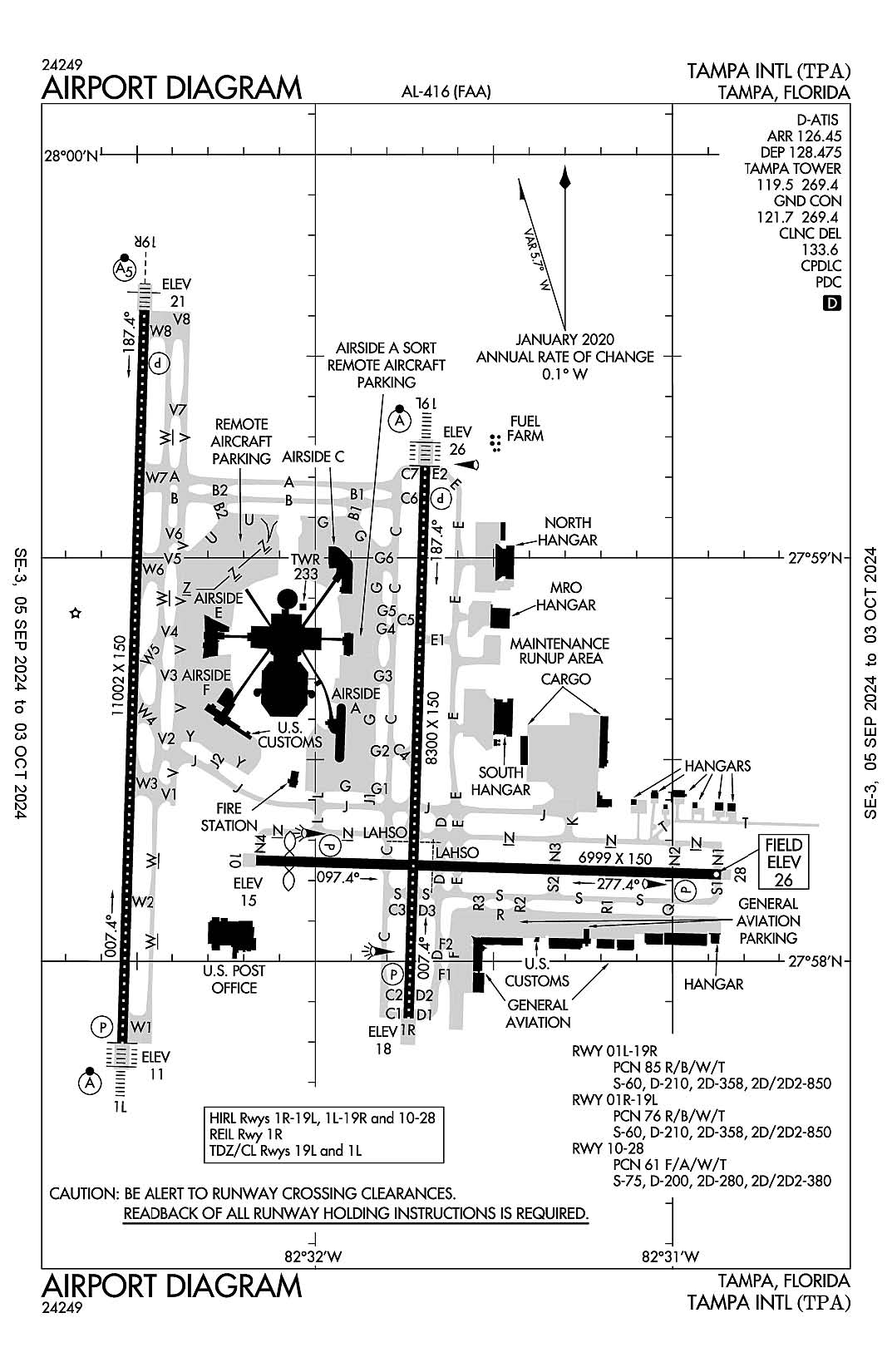
Tampa, Florida
Tampa International
ICAO Identifier KTPA
Tampa, FL
Tampa Intl
ICAO Identifier KTPA
AD 2.2 Aerodrome Geographical and Administrative Data
2.2.1 Reference Point: 27-58-31.7N / 82-31-59.7W
2.2.2 From City: 6 miles W of TAMPA, FL
2.2.3 Elevation: 26.4 ft
2.2.5 Magnetic Variation: 5W (2010)
2.2.6 Airport Contact: JOHN TILIACOS
PO BOX 22287
TAMPA, FL 33622 (813-870-8700)
2.2.7 Traffic: IFR/VFR
AD 2.3 Attendance Schedule
2.3.1 All Months, All Days, All Hours
AD 2.4 Handling Services and Facilities
2.4.1 Cargo Handling Facilities: YES
2.4.2 Fuel Types: 100LL A
2.4.5 Hangar Space: YES
2.4.6 Repair Facilities: MAJOR
AD 2.6 Rescue and Firefighting Services
2.6.1 Aerodrome Category: Class-I certified on 5/1/1973
2.6.2 Rescue and Firefighting Services: ARFF Index-D
AD 2.12 Runway Physical Characteristics
2.12.1 Designation: 19R
2.12.2 True Bearing: 182
2.12.3 True Dimensions: 11002 ft x 150 ft
2.12.4 PCN: 85 R/B/W/T
2.12.5 Coordinates: 27-59-36.7423N / 82-32-28.7801W
2.12.6 Threshold Elevation: 21
2.12.6 Touchdown Zone Elevation: 21
2.12.1 Designation: 01L
2.12.2 True Bearing: 2
2.12.3 True Dimensions: 11002 ft x 150 ft
2.12.4 PCN: 85 R/B/W/T
2.12.5 Coordinates: 27-57-47.8596N / 82-32-32.4793W
2.12.6 Threshold Elevation: 10.7
2.12.6 Touchdown Zone Elevation: 10.8
2.12.1 Designation: 19L
2.12.2 True Bearing: 182
2.12.3 True Dimensions: 8300 ft x 150 ft
2.12.4 PCN: 76 R/B/W/T
2.12.5 Coordinates: 27-59-13.6607N / 82-31-41.5739W
2.12.6 Threshold Elevation: 26
2.12.6 Touchdown Zone Elevation: 26.1
2.12.1 Designation: 01R
2.12.2 True Bearing: 2
2.12.3 True Dimensions: 8300 ft x 150 ft
2.12.4 PCN: 76 R/B/W/T
2.12.5 Coordinates: 27-57-51.5169N / 82-31-44.3687W
2.12.6 Threshold Elevation: 17.7
2.12.6 Touchdown Zone Elevation: 20.5
2.12.1 Designation: 10
2.12.2 True Bearing: 92
2.12.3 True Dimensions: 6999 ft x 150 ft
2.12.4 PCN: 61 F/A/W/T
2.12.5 Coordinates: 27-58-14.9917N / 82-32-09.9027W
2.12.6 Threshold Elevation: 14.5
2.12.6 Touchdown Zone Elevation: 21.8
2.12.1 Designation: 28
2.12.2 True Bearing: 272
2.12.3 True Dimensions: 6999 ft x 150 ft
2.12.4 PCN: 61 F/A/W/T
2.12.5 Coordinates: 27-58-12.8902N / 82-30-51.8781W
2.12.6 Threshold Elevation: 26.4
2.12.6 Touchdown Zone Elevation: 26.4
AD 2.13 Declared Distances
2.13.1 Designation: 19R
2.13.2 Take-off Run Available: 11002
2.13.3 Take-off Distance Available: 11002
2.13.4 Accelerate-Stop Distance Available: 11002
2.13.5 Landing Distance Available: 11002
2.13.1 Designation: 01L
2.13.2 Take-off Run Available: 11002
2.13.3 Take-off Distance Available: 11002
2.13.4 Accelerate-Stop Distance Available: 10800
2.13.5 Landing Distance Available: 10800
2.13.1 Designation: 19L
2.13.2 Take-off Run Available: 8300
2.13.3 Take-off Distance Available: 8300
2.13.4 Accelerate-Stop Distance Available: 8300
2.13.5 Landing Distance Available: 8300
2.13.1 Designation: 01R
2.13.2 Take-off Run Available: 8300
2.13.3 Take-off Distance Available: 8300
2.13.4 Accelerate-Stop Distance Available: 8300
2.13.5 Landing Distance Available: 8300
2.13.1 Designation: 10
2.13.2 Take-off Run Available: 6999
2.13.3 Take-off Distance Available: 6999
2.13.4 Accelerate-Stop Distance Available: 6999
2.13.5 Landing Distance Available: 6501
2.13.1 Designation: 28
2.13.2 Take-off Run Available: 6999
2.13.3 Take-off Distance Available: 6999
2.13.4 Accelerate-Stop Distance Available: 6501
2.13.5 Landing Distance Available: 6501
AD 2.14 Approach and Runway Lighting
2.14.1 Designation: 19R
2.14.2 Approach Lighting System: MALSR
2.14.4 Visual Approach Slope Indicator System: P4L
2.14.1 Designation: 01L
2.14.2 Approach Lighting System: ALSF2
2.14.4 Visual Approach Slope Indicator System: P4L
2.14.1 Designation: 19L
2.14.2 Approach Lighting System: ALSF2
2.14.4 Visual Approach Slope Indicator System: P4L
2.14.1 Designation: 01R
2.14.2 Approach Lighting System:
2.14.4 Visual Approach Slope Indicator System: P4L
2.14.1 Designation: 10
2.14.2 Approach Lighting System:
2.14.4 Visual Approach Slope Indicator System: P4L
2.14.1 Designation: 28
2.14.2 Approach Lighting System:
2.14.4 Visual Approach Slope Indicator System: P4L
AD 2.18 Air Traffic Services Communication Facilities
2.18.1 Service Designation: APCH/DEP/P (151-219)
2.18.3 Channel: 134.25
2.18.5 Hours of Operation: 24
2.18.1 Service Designation: APCH/P DEP/P (001-150)
2.18.3 Channel: 118.15
2.18.5 Hours of Operation: 24
2.18.1 Service Designation: APCH/P DEP/P (220-360)
2.18.3 Channel: 239.3
2.18.5 Hours of Operation: 24
2.18.1 Service Designation: APCH/P DEP/P (001-150)
2.18.3 Channel: 279.6
2.18.5 Hours of Operation: 24
2.18.1 Service Designation: APCH/P DEP/P (151-219)
2.18.3 Channel: 353.575
2.18.5 Hours of Operation: 24
2.18.1 Service Designation: APCH/P DEP/P IC
2.18.3 Channel: 307.175
2.18.5 Hours of Operation: 24
2.18.1 Service Designation: APCH/P IC
2.18.3 Channel: 118.5
2.18.5 Hours of Operation: 24
2.18.1 Service Designation: APCH/S DEP/S
2.18.3 Channel: 353.75
2.18.5 Hours of Operation: 24
2.18.1 Service Designation: BAYPO DP
2.18.3 Channel: 118.8
2.18.5 Hours of Operation: 24
2.18.1 Service Designation: BAYPO DP
2.18.3 Channel: 239.3
2.18.5 Hours of Operation: 24
2.18.1 Service Designation: BLFRG STAR
2.18.3 Channel: 119.65
2.18.5 Hours of Operation: 24
2.18.1 Service Designation: BLFRG STAR
2.18.3 Channel: 353.575
2.18.5 Hours of Operation: 24
2.18.1 Service Designation: BRDGE STAR
2.18.3 Channel: 119.65
2.18.5 Hours of Operation: 24
2.18.1 Service Designation: BRDGE STAR
2.18.3 Channel: 353.575
2.18.5 Hours of Operation: 24
2.18.1 Service Designation: CD/P
2.18.3 Channel: 133.6
2.18.5 Hours of Operation: 24
2.18.1 Service Designation: CLASS B (151-219)
2.18.3 Channel: 119.65
2.18.5 Hours of Operation: 24
2.18.1 Service Designation: CLASS B (001-150)
2.18.3 Channel: 119.9
2.18.5 Hours of Operation: 24
2.18.1 Service Designation: CLASS B (220-360)
2.18.3 Channel: 125.3
2.18.5 Hours of Operation: 24
2.18.1 Service Designation: CLASS B (001-150)
2.18.3 Channel: 290.3
2.18.5 Hours of Operation: 24
2.18.1 Service Designation: CLASS B (220-360)
2.18.3 Channel: 316.05
2.18.5 Hours of Operation: 24
2.18.1 Service Designation: CLASS B (151-219)
2.18.3 Channel: 353.575
2.18.5 Hours of Operation: 24
2.18.1 Service Designation: CROWD DP
2.18.3 Channel: 135.5
2.18.5 Hours of Operation: 24
2.18.1 Service Designation: CROWD DP
2.18.3 Channel: 279.6
2.18.5 Hours of Operation: 24
2.18.1 Service Designation: D-ATIS (ARR)
2.18.3 Channel: 126.45
2.18.5 Hours of Operation: 24
2.18.1 Service Designation: D-ATIS (DEP)
2.18.3 Channel: 128.475
2.18.5 Hours of Operation: 24
2.18.1 Service Designation: DADES STAR
2.18.3 Channel: 135.5
2.18.5 Hours of Operation: 24
2.18.1 Service Designation: DADES STAR
2.18.3 Channel: 279.6
2.18.5 Hours of Operation: 24
2.18.1 Service Designation: DEP/P IC (220-360)
2.18.3 Channel: 118.8
2.18.5 Hours of Operation: 24
2.18.1 Service Designation: DORMR DP
2.18.3 Channel: 118.8
2.18.5 Hours of Operation: 24
2.18.1 Service Designation: DORMR DP
2.18.3 Channel: 239.3
2.18.5 Hours of Operation: 24
2.18.1 Service Designation: EMERG
2.18.3 Channel: 121.5
2.18.5 Hours of Operation:
2.18.1 Service Designation: EMERG
2.18.3 Channel: 243
2.18.5 Hours of Operation:
2.18.1 Service Designation: ENDED DP
2.18.3 Channel: 118.8
2.18.5 Hours of Operation: 24
2.18.1 Service Designation: ENDED DP
2.18.3 Channel: 239.3
2.18.5 Hours of Operation: 24
2.18.1 Service Designation: GANDY DP
2.18.3 Channel: 119.65
2.18.5 Hours of Operation: 24
2.18.1 Service Designation: GANDY DP
2.18.3 Channel: 353.575
2.18.5 Hours of Operation: 24
2.18.1 Service Designation: GND/P
2.18.3 Channel: 121.7
2.18.5 Hours of Operation: 24
2.18.1 Service Designation: GND/P
2.18.3 Channel: 269.4
2.18.5 Hours of Operation: 24
2.18.1 Service Designation: GND/S
2.18.3 Channel: 121.35
2.18.5 Hours of Operation: 24
2.18.1 Service Designation: KNOST DP
2.18.3 Channel: 118.8
2.18.5 Hours of Operation: 24
2.18.1 Service Designation: KNOST DP
2.18.3 Channel: 239.3
2.18.5 Hours of Operation: 24
2.18.1 Service Designation: LCL/P
2.18.3 Channel: 119.5
2.18.5 Hours of Operation: 24
2.18.1 Service Designation: LCL/P
2.18.3 Channel: 269.4
2.18.5 Hours of Operation: 24
2.18.1 Service Designation: LCL/S
2.18.3 Channel: 119.05
2.18.5 Hours of Operation: 24
2.18.1 Service Designation: LGTNG DP
2.18.3 Channel: 118.8
2.18.5 Hours of Operation: 24
2.18.1 Service Designation: LGTNG DP
2.18.3 Channel: 239.3
2.18.5 Hours of Operation: 24
2.18.1 Service Designation: MAATY STAR
2.18.3 Channel: 118.8
2.18.5 Hours of Operation: 24
2.18.1 Service Designation: MAATY STAR
2.18.3 Channel: 239.3
2.18.5 Hours of Operation: 24
2.18.1 Service Designation: RAYZZ STAR
2.18.3 Channel: 118.8
2.18.5 Hours of Operation: 24
2.18.1 Service Designation: RAYZZ STAR
2.18.3 Channel: 239.3
2.18.5 Hours of Operation: 24
2.18.1 Service Designation: TAMPA DP
2.18.3 Channel: 134.25
2.18.5 Hours of Operation: 24
2.18.1 Service Designation: TAMPA DP
2.18.3 Channel: 279.6
2.18.5 Hours of Operation: 24
AD 2.19 Radio Navigation and Landing Aids
2.19.1 ILS Type: DME for runway 01L. Magnetic variation: 5W
2.19.2 ILS Identification: AMP
2.19.5 Coordinates: 27-59-43.4N / 82-32-25.65W
2.19.6 Site Elevation: 20 ft
2.19.1 ILS Type: Glide Slop for runway 01L. Magnetic variation: 5W
2.19.2 ILS Identification: AMP
2.19.5 Coordinates: 27-57-58.2392N / 82-32-36.5897W
2.19.6 Site Elevation: 7.6 ft
2.19.1 ILS Type: Inner Marker for runway 01L. Magnetic variation: 5W
2.19.2 ILS Identification: AMP
2.19.5 Coordinates: 27-57-39.6244N / 82-32-32.7564W
2.19.6 Site Elevation: 6.4 ft
2.19.1 ILS Type: Localizer for runway 01L. Magnetic variation: 5W
2.19.2 ILS Identification: AMP
2.19.5 Coordinates: 27-59-44.7869N / 82-32-28.5048W
2.19.6 Site Elevation: 20.6 ft
2.19.1 ILS Type: DME for runway 19R. Magnetic variation: 5W
2.19.2 ILS Identification: JRT
2.19.5 Coordinates: 27-57-37.34N / 82-32-31.94W
2.19.6 Site Elevation: 5 ft
2.19.1 ILS Type: Glide Slop for runway 19R. Magnetic variation: 5W
2.19.2 ILS Identification: JRT
2.19.5 Coordinates: 27-59-26.4582N / 82-32-33.5927W
2.19.6 Site Elevation: 17.2 ft
2.19.1 ILS Type: Localizer for runway 19R. Magnetic variation: 5W
2.19.2 ILS Identification: JRT
2.19.5 Coordinates: 27-57-37.46N / 82-32-32.84W
2.19.6 Site Elevation: 5 ft
2.19.1 ILS Type: DME for runway 01R. Magnetic variation: 5W
2.19.2 ILS Identification: TWJ
2.19.5 Coordinates: 27-59-22.9831N / 82-31-38.4291W
2.19.6 Site Elevation: 35.9 ft
2.19.1 ILS Type: Localizer for runway 01R. Magnetic variation: 5W
2.19.2 ILS Identification: TWJ
2.19.5 Coordinates: 27-59-23.9328N / 82-31-41.2197W
2.19.6 Site Elevation: 25.6 ft
2.19.1 ILS Type: DME for runway 19L. Magnetic variation: 5W
2.19.2 ILS Identification: TPA
2.19.5 Coordinates: 27-57-40.42N / 82-31-40.5W
2.19.6 Site Elevation: 10 ft
2.19.1 ILS Type: Glide Slop for runway 19L. Magnetic variation: 5W
2.19.2 ILS Identification: TPA
2.19.5 Coordinates: 27-59-03.1644N / 82-31-37.4636W
2.19.6 Site Elevation: 23.8 ft
2.19.1 ILS Type: Inner Marker for runway 19L. Magnetic variation: 5W
2.19.2 ILS Identification: TPA
2.19.5 Coordinates: 27-59-23.6601N / 82-31-41.2251W
2.19.6 Site Elevation: 25.7 ft
2.19.1 ILS Type: Localizer for runway 19L. Magnetic variation: 5W
2.19.2 ILS Identification: TPA
2.19.5 Coordinates: 27-57-40.972N / 82-31-44.7284W
2.19.6 Site Elevation: 13.7 ft
General Remarks:
TAXILANE G WEST OF TWY B1 CLSD TO WINGSPAN GTR THAN 118 FT - PPR APT OPS.
TXL K1 AND TXL K2 CLSD TO WINGSPANS GTR THAN 171 FT, TXL K1 AND TXL K2 CLSD WHILE WIDE BODY TXL K1W IS IN USE.
TXL F AND TXL R ARE NON-MOVEMENT AREAS. BOTH LCTNS ARE UNAVBL FOR GROUP IV ACFT WITH A WINGSPAN GTR THAN 117 FT WO PPR FROM ARPT OPS. TXL T PPR FROM ARPT OPS RQRD FOR ACFT WITH A WINGSPAN GTR THAN 90 FT.
RWY 19L IS NOISE SENSITIVE TO TBJT DEPARTURES. RWY 01R IS NOISE SENSITIVE TO TBJT ARRIVALS. PUBLD NOISE ABATEMENT PROCS IN EFCT.
BIRD ACT ON AND INVOF ARPT.
TWY J BTN TWY J1 AND TWY J2; TWY N W OF TWY L; TWY E N OF TWY J; TXL Z; TXL V BTN TWY V2 AND TWY V3 ARE UNAVBL FOR GROUP V ACFT WITH A WINGSPAN GTR THAN 171 FT WO PPR FROM ARPT OPS.
ONLY ACFT WITH PRIOR PMSN MAY USE TRML APN; ALL OTRS USE GA APN.
RSTRS TO ADG IV OR LGR: TWY E1.
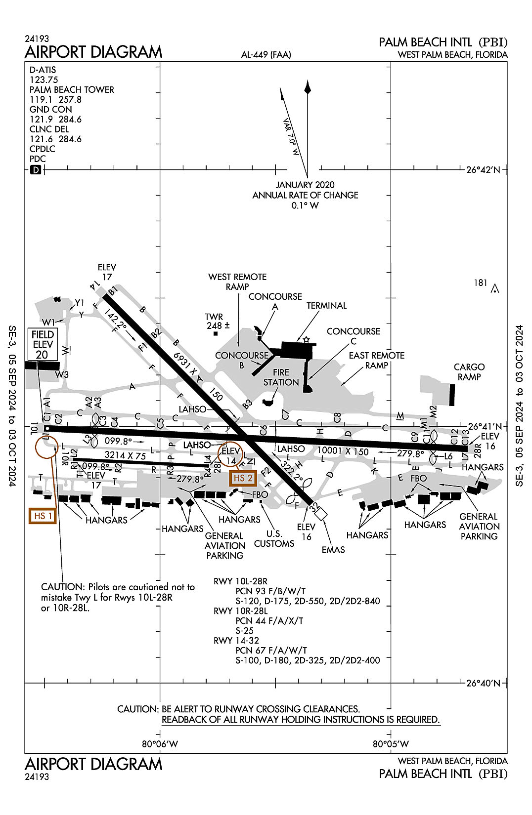
West Palm Beach, Florida
Palm Beach International
ICAO Identifier KPBI
West Palm Beach, FL
Palm Beach Intl
ICAO Identifier KPBI
AD 2.2 Aerodrome Geographical and Administrative Data
2.2.1 Reference Point: 26-40-59.382N / 80-05-44.131W
2.2.2 From City: 3 miles W of WEST PALM BEACH, FL
2.2.3 Elevation: 19.6 ft
2.2.5 Magnetic Variation: 6W (2010)
2.2.6 Airport Contact: LAURA BEEBE
846 PALM BEACH INTL AIRPORT
WEST PALM BEACH, FL 33406 (561-471-7420)
2.2.7 Traffic: IFR/VFR
AD 2.3 Attendance Schedule
2.3.1 All Months, All Days, All Hours
AD 2.4 Handling Services and Facilities
2.4.1 Cargo Handling Facilities: YES
2.4.2 Fuel Types: 100LL A
2.4.5 Hangar Space:
2.4.6 Repair Facilities: MAJOR
AD 2.6 Rescue and Firefighting Services
2.6.1 Aerodrome Category: Class-I certified on 5/21/1973
2.6.2 Rescue and Firefighting Services: ARFF Index-C
AD 2.12 Runway Physical Characteristics
2.12.1 Designation: 10L
2.12.2 True Bearing: 93
2.12.3 True Dimensions: 10001 ft x 150 ft
2.12.4 PCN: 93 F/B/W/T
2.12.5 Coordinates: 26-40-59.5493N / 80-06-30.1296W
2.12.6 Threshold Elevation: 19.6
2.12.6 Touchdown Zone Elevation: 16.3
2.12.1 Designation: 28R
2.12.2 True Bearing: 273
2.12.3 True Dimensions: 10001 ft x 150 ft
2.12.4 PCN: 93 F/B/W/T
2.12.5 Coordinates: 26-40-54.7438N / 80-04-40.0137W
2.12.6 Threshold Elevation: 16.4
2.12.6 Touchdown Zone Elevation: 18.3
2.12.1 Designation: 10R
2.12.2 True Bearing: 93
2.12.3 True Dimensions: 3214 ft x 75 ft
2.12.4 PCN: 44 F/A/X/T
2.12.5 Coordinates: 26-40-52.282N / 80-06-22.6416W
2.12.6 Threshold Elevation: 17.1
2.12.6 Touchdown Zone Elevation: 17.2
2.12.1 Designation: 28L
2.12.2 True Bearing: 273
2.12.3 True Dimensions: 3214 ft x 75 ft
2.12.4 PCN: 44 F/A/X/T
2.12.5 Coordinates: 26-40-50.7327N / 80-05-47.2501W
2.12.6 Threshold Elevation: 13.6
2.12.6 Touchdown Zone Elevation: 16.9
2.12.1 Designation: 14
2.12.2 True Bearing: 135
2.12.3 True Dimensions: 6931 ft x 150 ft
2.12.4 PCN: 67 F/A/W/T
2.12.5 Coordinates: 26-41-30.596N / 80-06-14.482W
2.12.6 Threshold Elevation: 17
2.12.6 Touchdown Zone Elevation: 17.3
2.12.1 Designation: 32
2.12.2 True Bearing: 315
2.12.3 True Dimensions: 6931 ft x 150 ft
2.12.4 PCN: 67 F/A/W/T
2.12.5 Coordinates: 26-40-41.913N / 80-05-20.622W
2.12.6 Threshold Elevation: 15.8
2.12.6 Touchdown Zone Elevation: 15.9
AD 2.13 Declared Distances
2.13.1 Designation: 10L
2.13.2 Take-off Run Available: 10001
2.13.3 Take-off Distance Available: 10001
2.13.4 Accelerate-Stop Distance Available: 9351
2.13.5 Landing Distance Available: 8151
2.13.1 Designation: 28R
2.13.2 Take-off Run Available: 10001
2.13.3 Take-off Distance Available: 10001
2.13.4 Accelerate-Stop Distance Available: 9051
2.13.5 Landing Distance Available: 8240
2.13.1 Designation: 10R
2.13.2 Take-off Run Available: 3214
2.13.3 Take-off Distance Available: 3214
2.13.4 Accelerate-Stop Distance Available: 3214
2.13.5 Landing Distance Available: 3214
2.13.1 Designation: 28L
2.13.2 Take-off Run Available: 3214
2.13.3 Take-off Distance Available: 3214
2.13.4 Accelerate-Stop Distance Available: 3214
2.13.5 Landing Distance Available: 3214
2.13.1 Designation: 14
2.13.2 Take-off Run Available: 6926
2.13.3 Take-off Distance Available: 6926
2.13.4 Accelerate-Stop Distance Available: 6000
2.13.5 Landing Distance Available: 6000
2.13.1 Designation: 32
2.13.2 Take-off Run Available: 6926
2.13.3 Take-off Distance Available: 6926
2.13.4 Accelerate-Stop Distance Available: 6926
2.13.5 Landing Distance Available: 6513
AD 2.14 Approach and Runway Lighting
2.14.1 Designation: 10L
2.14.2 Approach Lighting System: MALSR
2.14.4 Visual Approach Slope Indicator System: P4R
2.14.1 Designation: 28R
2.14.2 Approach Lighting System:
2.14.4 Visual Approach Slope Indicator System: P4L
2.14.1 Designation: 10R
2.14.2 Approach Lighting System:
2.14.4 Visual Approach Slope Indicator System:
2.14.1 Designation: 28L
2.14.2 Approach Lighting System:
2.14.4 Visual Approach Slope Indicator System:
2.14.1 Designation: 14
2.14.2 Approach Lighting System:
2.14.4 Visual Approach Slope Indicator System: P4R
2.14.1 Designation: 32
2.14.2 Approach Lighting System:
2.14.4 Visual Approach Slope Indicator System: P4L
AD 2.18 Air Traffic Services Communication Facilities
2.18.1 Service Designation: APCH/P DEP/P (SOUTH)
2.18.3 Channel: 125.2
2.18.5 Hours of Operation: 24
2.18.1 Service Designation: APCH/P DEP/P (SOUTH)
2.18.3 Channel: 343.6
2.18.5 Hours of Operation: 24
2.18.1 Service Designation: APCH/P DEP/P IC
2.18.3 Channel: 128.3
2.18.5 Hours of Operation: 24
2.18.1 Service Designation: APCH/P DEP/P IC
2.18.3 Channel: 317.4
2.18.5 Hours of Operation: 24
2.18.1 Service Designation: CD/P
2.18.3 Channel: 121.6
2.18.5 Hours of Operation: 24
2.18.1 Service Designation: CD/P
2.18.3 Channel: 284.6
2.18.5 Hours of Operation: 24
2.18.1 Service Designation: CLASS C (SOUTH)
2.18.3 Channel: 125.2
2.18.5 Hours of Operation: 24
2.18.1 Service Designation: CLASS C (NORTH)
2.18.3 Channel: 128.3
2.18.5 Hours of Operation: 24
2.18.1 Service Designation: CLASS C (NORTH)
2.18.3 Channel: 317.4
2.18.5 Hours of Operation: 24
2.18.1 Service Designation: CLASS C (SOUTH)
2.18.3 Channel: 343.6
2.18.5 Hours of Operation: 24
2.18.1 Service Designation: CLMNT STAR
2.18.3 Channel: 124.6
2.18.5 Hours of Operation: 24
2.18.1 Service Designation: CLMNT STAR
2.18.3 Channel: 317.4
2.18.5 Hours of Operation: 24
2.18.1 Service Designation: CPTAN STAR
2.18.3 Channel: 124.6
2.18.5 Hours of Operation: 24
2.18.1 Service Designation: CPTAN STAR
2.18.3 Channel: 317.4
2.18.5 Hours of Operation: 24
2.18.1 Service Designation: D-ATIS
2.18.3 Channel: 123.75
2.18.5 Hours of Operation: 24
2.18.1 Service Designation: EMERG
2.18.3 Channel: 121.5
2.18.5 Hours of Operation:
2.18.1 Service Designation: EMERG
2.18.3 Channel: 243
2.18.5 Hours of Operation:
2.18.1 Service Designation: GND/P
2.18.3 Channel: 121.9
2.18.5 Hours of Operation: 24
2.18.1 Service Designation: GND/P
2.18.3 Channel: 284.6
2.18.5 Hours of Operation: 24
2.18.1 Service Designation: JESTR STAR
2.18.3 Channel: 124.6
2.18.5 Hours of Operation: 24
2.18.1 Service Designation: JESTR STAR
2.18.3 Channel: 317.4
2.18.5 Hours of Operation: 24
2.18.1 Service Designation: LCL/P
2.18.3 Channel: 119.1
2.18.5 Hours of Operation: 24
2.18.1 Service Designation: LCL/P
2.18.3 Channel: 257.8
2.18.5 Hours of Operation: 24
2.18.1 Service Designation: LCL/S
2.18.3 Channel: 118.75
2.18.5 Hours of Operation: 24
2.18.1 Service Designation: LCL/S
2.18.3 Channel: 384.6
2.18.5 Hours of Operation: 24
2.18.1 Service Designation: MAHHI STAR
2.18.3 Channel: 127.35
2.18.5 Hours of Operation: 24
2.18.1 Service Designation: MAHHI STAR
2.18.3 Channel: 343.6
2.18.5 Hours of Operation: 24
2.18.1 Service Designation: MELBOURNE STAR
2.18.3 Channel: 124.6
2.18.5 Hours of Operation: 24
2.18.1 Service Designation: MELBOURNE STAR
2.18.3 Channel: 317.4
2.18.5 Hours of Operation: 24
2.18.1 Service Designation: MIXAE DP (RWY 10L, 14)
2.18.3 Channel: 127.35
2.18.5 Hours of Operation: 24
2.18.1 Service Designation: MIXAE DP (RWY 28R, 32)
2.18.3 Channel: 128.3
2.18.5 Hours of Operation: 24
2.18.1 Service Designation: MIXAE DP (RWY 28R, 32)
2.18.3 Channel: 317.4
2.18.5 Hours of Operation: 24
2.18.1 Service Designation: MIXAE DP (RWY 10L, 14)
2.18.3 Channel: 343.6
2.18.5 Hours of Operation: 24
2.18.1 Service Designation: OLAKE DP
2.18.3 Channel: 128.3
2.18.5 Hours of Operation: 24
2.18.1 Service Designation: OLAKE DP
2.18.3 Channel: 317.4
2.18.5 Hours of Operation: 24
2.18.1 Service Designation: PALM BEACH DP (SOUTH)
2.18.3 Channel: 127.35
2.18.5 Hours of Operation: 24
2.18.1 Service Designation: PALM BEACH DP (NORTH)
2.18.3 Channel: 128.3
2.18.5 Hours of Operation: 24
2.18.1 Service Designation: PALM BEACH DP (NORTH)
2.18.3 Channel: 317.4
2.18.5 Hours of Operation: 24
2.18.1 Service Designation: PALM BEACH DP (SOUTH)
2.18.3 Channel: 343.6
2.18.5 Hours of Operation: 24
2.18.1 Service Designation: SLIDZ DP
2.18.3 Channel: 128.3
2.18.5 Hours of Operation: 24
2.18.1 Service Designation: SLIDZ DP
2.18.3 Channel: 317.4
2.18.5 Hours of Operation: 24
2.18.1 Service Designation: STOOP STAR
2.18.3 Channel: 124.6
2.18.5 Hours of Operation: 24
2.18.1 Service Designation: STOOP STAR
2.18.3 Channel: 317.4
2.18.5 Hours of Operation: 24
2.18.1 Service Designation: TBIRD DP
2.18.3 Channel: 128.3
2.18.5 Hours of Operation: 24
2.18.1 Service Designation: TBIRD DP
2.18.3 Channel: 317.4
2.18.5 Hours of Operation: 24
2.18.1 Service Designation: TTYLR STAR
2.18.3 Channel: 125.2
2.18.5 Hours of Operation: 24
2.18.1 Service Designation: TTYLR STAR
2.18.3 Channel: 317.4
2.18.5 Hours of Operation: 24
2.18.1 Service Designation: VUUDU STAR
2.18.3 Channel: 127.35
2.18.5 Hours of Operation: 24
2.18.1 Service Designation: VUUDU STAR
2.18.3 Channel: 317.4
2.18.5 Hours of Operation: 24
2.18.1 Service Designation: WELLY DP
2.18.3 Channel: 127.35
2.18.5 Hours of Operation: 24
2.18.1 Service Designation: WELLY DP
2.18.3 Channel: 343.6
2.18.5 Hours of Operation: 24
AD 2.19 Radio Navigation and Landing Aids
2.19.1 ILS Type: DME for runway 10L. Magnetic variation: 6W
2.19.2 ILS Identification: PBI
2.19.5 Coordinates: 26-40-51.4319N / 80-04-29.0092W
2.19.6 Site Elevation: 23.3 ft
2.19.1 ILS Type: Glide Slop for runway 10L. Magnetic variation: 6W
2.19.2 ILS Identification: PBI
2.19.5 Coordinates: 26-40-55.9795N / 80-06-06.0748W
2.19.6 Site Elevation: 14.5 ft
2.19.1 ILS Type: Localizer for runway 10L. Magnetic variation: 6W
2.19.2 ILS Identification: PBI
2.19.5 Coordinates: 26-40-54.2434N / 80-04-28.6079W
2.19.6 Site Elevation: 13 ft
2.19.1 ILS Type: Glide Slop for runway 28R. Magnetic variation: 6W
2.19.2 ILS Identification: PWB
2.19.5 Coordinates: 26-40-53.0853N / 80-05-01.7298W
2.19.6 Site Elevation: 13.5 ft
2.19.1 ILS Type: Localizer for runway 28R. Magnetic variation: 6W
2.19.2 ILS Identification: PWB
2.19.5 Coordinates: 26-40-59.9773N / 80-06-39.9822W
2.19.6 Site Elevation: 18.5 ft
2.19.1 Navigation Aid Type VORTAC. Magnetic variation: 3W
2.19.2 Navigation Aid Identification: PBI
2.19.5 Coordinates: 26-40-48.198N / 80-05-11.3635W
2.19.6 Site Elevation: 15.7 ft
General Remarks:
BE ALERT: TWY L IS LCTD BTWN RYS 10L/28R & 10R/28L. TWY L IS WIDER AND LONGER THAN RY 10R/28L - DO NOT CONFUSE TWY L FOR RY. AIRCRAFT WITH WINGSPAN OF 118 FT OR GREATER IS PROHIBITED ON TWY L.
ACFT WITH WINGSPANS GTR THAN 118 FT MAY NOT OPR ON TWY E, TWY W, TWY Y AND TWY F NW OF TWY A.
ACFT WITH WINGSPANS GTR THAN 49 MAY NOT OPER SIMUL ON RWY 10R/28L AND TWY R.
24 HR PPR FOR ACFT WITH WINGSPANS GTR THAN 171 FT.
RWY 10R/28L NOT AVBL FOR SKED ACR OPS WITH MORE THAN 9 PAX SEATS OR UNSKED ACR AT LEAST 31 PAX SEATS.
RWY 14 LAHSO SIGNAGE NOT STD.
RWY 10L/28R SAFETY AREA NOT STD SFC VARNS.
NOISE ABATEMENT PROCEDURES IN EFFECT. MULTIENGINE FLIGHT TRAINING PROHIBITED SS TO SR SUN AND HOLIDAY; STRICT ENVIRONMENTAL OPERATING STAGE 2 ACFT 0300-1200Z CALL NOISE ABATEMENT OFFICER 561-471-7467.
BE ALERT; RYS 28L & 28R THLDS STAGGERED BY 5400 FT.
RWY 14/32 SAFETY AREA NOT STD SFC VARNS.
MIGRATORY BIRDS ON AND INVOF ARPT.