Michigan
Detroit, Michigan
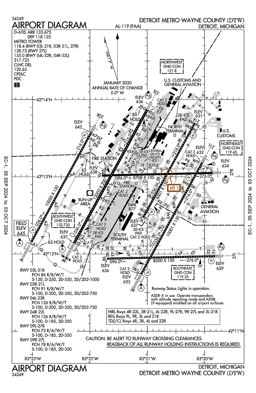
Detroit Metropolitan Wayne County
ICAO Identifier KDTW
Detroit, MI
Detroit Metropolitan Wayne County
ICAO Identifier KDTW
AD 2.2 Aerodrome Geographical and Administrative Data
2.2.1 Reference Point: 42-12-44.752N / 83-21-12.216W
2.2.2 From City: 15 miles S of DETROIT, MI
2.2.3 Elevation: 645.2 ft
2.2.5 Magnetic Variation: 7W (2020)
2.2.6 Airport Contact: CHAD NEWTON
11050 ROGELL DR #602
DETROIT, MI 48242 (734-942-3685)
2.2.7 Traffic: IFR/VFR
AD 2.3 Attendance Schedule
2.3.1 All Months, All Days, All Hours
AD 2.4 Handling Services and Facilities
2.4.1 Cargo Handling Facilities: YES
2.4.2 Fuel Types: 100LL A
2.4.5 Hangar Space: YES
2.4.6 Repair Facilities: NONE
AD 2.6 Rescue and Firefighting Services
2.6.1 Aerodrome Category: Class-I certified on 5/1/1973
2.6.2 Rescue and Firefighting Services: ARFF Index-E
AD 2.12 Runway Physical Characteristics
2.12.1 Designation: 21R
2.12.2 True Bearing: 209
2.12.3 True Dimensions: 8501 ft x 150 ft
2.12.4 PCN: 86 R/B/W/T
2.12.5 Coordinates: 42-13-41.8586N / 83-20-10.107W
2.12.6 Threshold Elevation: 631.4
2.12.6 Touchdown Zone Elevation: 634.5
2.12.1 Designation: 03L
2.12.2 True Bearing: 29
2.12.3 True Dimensions: 8501 ft x 150 ft
2.12.4 PCN: 86 R/B/W/T
2.12.5 Coordinates: 42-12-28.2081N / 83-21-04.3881W
2.12.6 Threshold Elevation: 636.5
2.12.6 Touchdown Zone Elevation: 636.9
2.12.1 Designation: 03R
2.12.2 True Bearing: 29
2.12.3 True Dimensions: 10001 ft x 150 ft
2.12.4 PCN: 91 R/B/W/T
2.12.5 Coordinates: 42-11-44.2115N / 83-21-06.4868W
2.12.6 Threshold Elevation: 632.8
2.12.6 Touchdown Zone Elevation: 633.1
2.12.1 Designation: 21L
2.12.2 True Bearing: 209
2.12.3 True Dimensions: 10001 ft x 150 ft
2.12.4 PCN: 91 R/B/W/T
2.12.5 Coordinates: 42-13-10.8552N / 83-20-02.6517W
2.12.6 Threshold Elevation: 631.8
2.12.6 Touchdown Zone Elevation: 632.3
2.12.1 Designation: 22R
2.12.2 True Bearing: 209
2.12.3 True Dimensions: 10000 ft x 150 ft
2.12.4 PCN: 126 R/B/W/T
2.12.5 Coordinates: 42-13-34.4821N / 83-21-58.6115W
2.12.6 Threshold Elevation: 642.1
2.12.6 Touchdown Zone Elevation: 642.1
2.12.1 Designation: 04L
2.12.2 True Bearing: 29
2.12.3 True Dimensions: 10000 ft x 150 ft
2.12.4 PCN: 126 R/B/W/T
2.12.5 Coordinates: 42-12-07.8216N / 83-23-02.4003W
2.12.6 Threshold Elevation: 645.2
2.12.6 Touchdown Zone Elevation: 645.2
2.12.1 Designation: 22L
2.12.2 True Bearing: 209
2.12.3 True Dimensions: 12003 ft x 200 ft
2.12.4 PCN: 126 R/B/W/T
2.12.5 Coordinates: 42-13-52.3644N / 83-20-59.9655W
2.12.6 Threshold Elevation: 635.8
2.12.6 Touchdown Zone Elevation: 637.4
2.12.1 Designation: 04R
2.12.2 True Bearing: 29
2.12.3 True Dimensions: 12003 ft x 200 ft
2.12.4 PCN: 126 R/B/W/T
2.12.5 Coordinates: 42-12-08.3656N / 83-22-16.5697W
2.12.6 Threshold Elevation: 637
2.12.6 Touchdown Zone Elevation: 639.5
2.12.1 Designation: 04X
2.12.2 True Bearing: 29
2.12.3 True Dimensions: 0 ft x 0 ft
2.12.4 PCN:
2.12.5 Coordinates:
2.12.6 Threshold Elevation:
2.12.6 Touchdown Zone Elevation:
2.12.1 Designation: 22X
2.12.2 True Bearing: 209
2.12.3 True Dimensions: 0 ft x 0 ft
2.12.4 PCN:
2.12.5 Coordinates:
2.12.6 Threshold Elevation:
2.12.6 Touchdown Zone Elevation:
2.12.1 Designation: 27R
2.12.2 True Bearing: 269
2.12.3 True Dimensions: 8708 ft x 150 ft
2.12.4 PCN: 73 R/A/W/T
2.12.5 Coordinates: 42-13-03.0219N / 83-19-51.7146W
2.12.6 Threshold Elevation: 634.3
2.12.6 Touchdown Zone Elevation: 634.7
2.12.1 Designation: 09L
2.12.2 True Bearing: 89
2.12.3 True Dimensions: 8708 ft x 150 ft
2.12.4 PCN: 73 R/A/W/T
2.12.5 Coordinates: 42-13-01.0821N / 83-21-47.4044W
2.12.6 Threshold Elevation: 638
2.12.6 Touchdown Zone Elevation: 639.6
2.12.1 Designation: 27L
2.12.2 True Bearing: 269
2.12.3 True Dimensions: 8500 ft x 150 ft
2.12.4 PCN: 78 R/A/W/T
2.12.5 Coordinates: 42-11-58.3372N / 83-19-49.3276W
2.12.6 Threshold Elevation: 629
2.12.6 Touchdown Zone Elevation: 630.1
2.12.1 Designation: 09R
2.12.2 True Bearing: 89
2.12.3 True Dimensions: 8500 ft x 150 ft
2.12.4 PCN: 78 R/A/W/T
2.12.5 Coordinates: 42-11-56.4542N / 83-21-42.2248W
2.12.6 Threshold Elevation: 636
2.12.6 Touchdown Zone Elevation: 636.1
AD 2.13 Declared Distances
2.13.1 Designation: 21R
2.13.2 Take-off Run Available: 8501
2.13.3 Take-off Distance Available: 8501
2.13.4 Accelerate-Stop Distance Available: 8501
2.13.5 Landing Distance Available: 8501
2.13.1 Designation: 03L
2.13.2 Take-off Run Available: 8501
2.13.3 Take-off Distance Available: 8501
2.13.4 Accelerate-Stop Distance Available: 8501
2.13.5 Landing Distance Available: 8501
2.13.1 Designation: 03R
2.13.2 Take-off Run Available: 10001
2.13.3 Take-off Distance Available: 10001
2.13.4 Accelerate-Stop Distance Available: 10001
2.13.5 Landing Distance Available: 10001
2.13.1 Designation: 21L
2.13.2 Take-off Run Available: 10001
2.13.3 Take-off Distance Available: 10001
2.13.4 Accelerate-Stop Distance Available: 10001
2.13.5 Landing Distance Available: 10001
2.13.1 Designation: 22R
2.13.2 Take-off Run Available: 10000
2.13.3 Take-off Distance Available: 10000
2.13.4 Accelerate-Stop Distance Available: 10000
2.13.5 Landing Distance Available: 10000
2.13.1 Designation: 04L
2.13.2 Take-off Run Available: 10000
2.13.3 Take-off Distance Available: 10000
2.13.4 Accelerate-Stop Distance Available: 10000
2.13.5 Landing Distance Available: 10000
2.13.1 Designation: 22L
2.13.2 Take-off Run Available: 12003
2.13.3 Take-off Distance Available: 12003
2.13.4 Accelerate-Stop Distance Available: 12003
2.13.5 Landing Distance Available: 12003
2.13.1 Designation: 04R
2.13.2 Take-off Run Available: 12003
2.13.3 Take-off Distance Available: 12003
2.13.4 Accelerate-Stop Distance Available: 12003
2.13.5 Landing Distance Available: 11494
2.13.1 Designation: 04X
2.13.2 Take-off Run Available:
2.13.3 Take-off Distance Available:
2.13.4 Accelerate-Stop Distance Available:
2.13.5 Landing Distance Available:
2.13.1 Designation: 22X
2.13.2 Take-off Run Available:
2.13.3 Take-off Distance Available:
2.13.4 Accelerate-Stop Distance Available:
2.13.5 Landing Distance Available:
2.13.1 Designation: 27R
2.13.2 Take-off Run Available: 8708
2.13.3 Take-off Distance Available: 8708
2.13.4 Accelerate-Stop Distance Available: 8708
2.13.5 Landing Distance Available: 8708
2.13.1 Designation: 09L
2.13.2 Take-off Run Available: 8708
2.13.3 Take-off Distance Available: 8708
2.13.4 Accelerate-Stop Distance Available: 8618
2.13.5 Landing Distance Available: 8618
2.13.1 Designation: 27L
2.13.2 Take-off Run Available: 8500
2.13.3 Take-off Distance Available: 8500
2.13.4 Accelerate-Stop Distance Available: 8500
2.13.5 Landing Distance Available: 8500
2.13.1 Designation: 09R
2.13.2 Take-off Run Available: 8500
2.13.3 Take-off Distance Available: 8500
2.13.4 Accelerate-Stop Distance Available: 8500
2.13.5 Landing Distance Available: 8500
AD 2.14 Approach and Runway Lighting
2.14.1 Designation: 21R
2.14.2 Approach Lighting System:
2.14.4 Visual Approach Slope Indicator System: P4L
2.14.1 Designation: 03L
2.14.2 Approach Lighting System:
2.14.4 Visual Approach Slope Indicator System: P4R
2.14.1 Designation: 03R
2.14.2 Approach Lighting System: ALSF2
2.14.4 Visual Approach Slope Indicator System: P4R
2.14.1 Designation: 21L
2.14.2 Approach Lighting System: MALSR
2.14.4 Visual Approach Slope Indicator System: P4L
2.14.1 Designation: 22R
2.14.2 Approach Lighting System: MALSR
2.14.4 Visual Approach Slope Indicator System: P4R
2.14.1 Designation: 04L
2.14.2 Approach Lighting System: ALSF2
2.14.4 Visual Approach Slope Indicator System: P4L
2.14.1 Designation: 22L
2.14.2 Approach Lighting System: MALSR
2.14.4 Visual Approach Slope Indicator System:
2.14.1 Designation: 04R
2.14.2 Approach Lighting System: ALSF2
2.14.4 Visual Approach Slope Indicator System:
2.14.1 Designation: 04X
2.14.2 Approach Lighting System:
2.14.4 Visual Approach Slope Indicator System:
2.14.1 Designation: 22X
2.14.2 Approach Lighting System:
2.14.4 Visual Approach Slope Indicator System:
2.14.1 Designation: 27R
2.14.2 Approach Lighting System: MALSR
2.14.4 Visual Approach Slope Indicator System: P4L
2.14.1 Designation: 09L
2.14.2 Approach Lighting System:
2.14.4 Visual Approach Slope Indicator System:
2.14.1 Designation: 27L
2.14.2 Approach Lighting System: MALSR
2.14.4 Visual Approach Slope Indicator System: P4L
2.14.1 Designation: 09R
2.14.2 Approach Lighting System:
2.14.4 Visual Approach Slope Indicator System:
AD 2.18 Air Traffic Services Communication Facilities
2.18.1 Service Designation: CD PRE TAXI CLNC
2.18.3 Channel: 120.65
2.18.5 Hours of Operation: 24
2.18.1 Service Designation: D-ATIS (DEP)
2.18.3 Channel: 118.125
2.18.5 Hours of Operation: 24
2.18.1 Service Designation: D-ATIS (ARR)
2.18.3 Channel: 133.675
2.18.5 Hours of Operation: 24
2.18.1 Service Designation: EMERG
2.18.3 Channel: 121.5
2.18.5 Hours of Operation:
2.18.1 Service Designation: EMERG
2.18.3 Channel: 243
2.18.5 Hours of Operation:
2.18.1 Service Designation: GND/P (SOUTHEAST)
2.18.3 Channel: 119.25
2.18.5 Hours of Operation: 24
2.18.1 Service Designation: GND/P (NORTHEAST)
2.18.3 Channel: 119.45
2.18.5 Hours of Operation: 24
2.18.1 Service Designation: GND/P (NORTHWEST)
2.18.3 Channel: 121.8
2.18.5 Hours of Operation: 24
2.18.1 Service Designation: GND/P (SOUTHWEST)
2.18.3 Channel: 132.725
2.18.5 Hours of Operation: 24
2.18.1 Service Designation: LCL/P (ARRIVAL RWY 03R/21L, 27R)
2.18.3 Channel: 118.4
2.18.5 Hours of Operation: 24
2.18.1 Service Designation: LCL/P (DEP, ARPT DIAG RWY 03L/21R, 03R/21L, 27R)
2.18.3 Channel: 118.4
2.18.5 Hours of Operation: 24
2.18.1 Service Designation: LCL/P (ARRIVAL RWY 04R/22L)
2.18.3 Channel: 128.125
2.18.5 Hours of Operation: 24
2.18.1 Service Designation: LCL/P (ARRIVAL RWY 03L/21R, 27L)
2.18.3 Channel: 128.75
2.18.5 Hours of Operation: 24
2.18.1 Service Designation: LCL/P (DEP, ARPT DIAG RWY 27L)
2.18.3 Channel: 128.75
2.18.5 Hours of Operation: 24
2.18.1 Service Designation: LCL/P (ARRIVAL RWY 04L/22R)
2.18.3 Channel: 135
2.18.5 Hours of Operation: 24
2.18.1 Service Designation: LCL/P (DEP, ARPT DIAG RWY 04L/22R, 04R/22L)
2.18.3 Channel: 135
2.18.5 Hours of Operation: 24
2.18.1 Service Designation: LCL/P
2.18.3 Channel: 317.725
2.18.5 Hours of Operation: 24
2.18.1 Service Designation: MEDEVAC
2.18.3 Channel: 259.6
2.18.5 Hours of Operation:
AD 2.19 Radio Navigation and Landing Aids
2.19.1 ILS Type: DME for runway 03R. Magnetic variation: 7W
2.19.2 ILS Identification: HUU
2.19.5 Coordinates: 42-11-34.2185N / 83-21-09.5792W
2.19.6 Site Elevation: 638.7 ft
2.19.1 ILS Type: Glide Slop for runway 03R. Magnetic variation: 7W
2.19.2 ILS Identification: HUU
2.19.5 Coordinates: 42-11-51.1266N / 83-20-54.979W
2.19.6 Site Elevation: 630.1 ft
2.19.1 ILS Type: Inner Marker for runway 03R. Magnetic variation: 7W
2.19.2 ILS Identification: HUU
2.19.5 Coordinates: 42-11-36.5551N / 83-21-12.137W
2.19.6 Site Elevation: 631.1 ft
2.19.1 ILS Type: Localizer for runway 03R. Magnetic variation: 7W
2.19.2 ILS Identification: HUU
2.19.5 Coordinates: 42-13-20.4082N / 83-19-55.609W
2.19.6 Site Elevation: 634 ft
2.19.1 ILS Type: DME for runway 21L. Magnetic variation: 7W
2.19.2 ILS Identification: EJR
2.19.5 Coordinates: 42-11-34.2185N / 83-21-09.5792W
2.19.6 Site Elevation: 638.7 ft
2.19.1 ILS Type: Glide Slop for runway 21L. Magnetic variation: 7W
2.19.2 ILS Identification: EJR
2.19.5 Coordinates: 42-12-58.4945N / 83-20-05.1867W
2.19.6 Site Elevation: 628.9 ft
2.19.1 ILS Type: Localizer for runway 21L. Magnetic variation: 7W
2.19.2 ILS Identification: EJR
2.19.5 Coordinates: 42-11-34.9459N / 83-21-13.3158W
2.19.6 Site Elevation: 631.1 ft
2.19.1 ILS Type: DME for runway 04L. Magnetic variation: 7W
2.19.2 ILS Identification: HJT
2.19.5 Coordinates: 42-13-41.8988N / 83-21-48.7254W
2.19.6 Site Elevation: 649.7 ft
2.19.1 ILS Type: Glide Slop for runway 04L. Magnetic variation: 7W
2.19.2 ILS Identification: HJT
2.19.5 Coordinates: 42-12-18.9498N / 83-23-00.2665W
2.19.6 Site Elevation: 640.6 ft
2.19.1 ILS Type: Inner Marker for runway 04L. Magnetic variation: 7W
2.19.2 ILS Identification: HJT
2.19.5 Coordinates: 42-12-00.3838N / 83-23-07.8811W
2.19.6 Site Elevation: 645.2 ft
2.19.1 ILS Type: Localizer for runway 04L. Magnetic variation: 7W
2.19.2 ILS Identification: HJT
2.19.5 Coordinates: 42-13-43.2279N / 83-21-52.161W
2.19.6 Site Elevation: 642 ft
2.19.1 ILS Type: DME for runway 22R. Magnetic variation: 7W
2.19.2 ILS Identification: JKI
2.19.5 Coordinates: 42-13-41.8988N / 83-21-48.7254W
2.19.6 Site Elevation: 649.7 ft
2.19.1 ILS Type: Glide Slop for runway 22R. Magnetic variation: 7W
2.19.2 ILS Identification: JKI
2.19.5 Coordinates: 42-13-27.2272N / 83-22-10.0062W
2.19.6 Site Elevation: 636.7 ft
2.19.1 ILS Type: Localizer for runway 22R. Magnetic variation: 7W
2.19.2 ILS Identification: JKI
2.19.5 Coordinates: 42-11-59.0707N / 83-23-08.842W
2.19.6 Site Elevation: 644.6 ft
2.19.1 ILS Type: DME for runway 04R. Magnetic variation: 7W
2.19.2 ILS Identification: DTW
2.19.5 Coordinates: 42-13-59.7252N / 83-20-50.3339W
2.19.6 Site Elevation: 645.3 ft
2.19.1 ILS Type: Glide Slop for runway 04R. Magnetic variation: 7W
2.19.2 ILS Identification: DTW
2.19.5 Coordinates: 42-12-23.21N / 83-22-11.85W
2.19.6 Site Elevation: 633.1 ft
2.19.1 ILS Type: Inner Marker for runway 04R. Magnetic variation: 7W
2.19.2 ILS Identification: DTW
2.19.5 Coordinates: 42-12-04.547N / 83-22-19.3737W
2.19.6 Site Elevation: 637.1 ft
2.19.1 ILS Type: Localizer for runway 04R. Magnetic variation: 7W
2.19.2 ILS Identification: DTW
2.19.5 Coordinates: 42-14-01.3028N / 83-20-53.3772W
2.19.6 Site Elevation: 636.5 ft
2.19.1 ILS Type: DME for runway 22L. Magnetic variation: 7W
2.19.2 ILS Identification: DWC
2.19.5 Coordinates: 42-13-59.7252N / 83-20-50.3339W
2.19.6 Site Elevation: 645.3 ft
2.19.1 ILS Type: Glide Slop for runway 22L. Magnetic variation: 7W
2.19.2 ILS Identification: DWC
2.19.5 Coordinates: 42-13-43.8552N / 83-21-12.2894W
2.19.6 Site Elevation: 635.6 ft
2.19.1 ILS Type: Localizer for runway 22L. Magnetic variation: 7W
2.19.2 ILS Identification: DWC
2.19.5 Coordinates: 42-11-59.5406N / 83-22-23.0644W
2.19.6 Site Elevation: 636.1 ft
2.19.1 ILS Type: DME for runway 04X. Magnetic variation: 7W
2.19.2 ILS Identification: ALA
2.19.5 Coordinates: 42-11-57.1056N / 83-23-06.1821W
2.19.6 Site Elevation: 656.6 ft
2.19.1 ILS Type: Glide Slop for runway 04X. Magnetic variation: 7W
2.19.2 ILS Identification: ALA
2.19.5 Coordinates: 42-12-19.0378N / 83-23-00.5079W
2.19.6 Site Elevation: 640.7 ft
2.19.1 ILS Type: Localizer for runway 04X. Magnetic variation: 7W
2.19.2 ILS Identification: ALA
2.19.5 Coordinates: 42-13-33.4002N / 83-21-50.9401W
2.19.6 Site Elevation: 638.5 ft
2.19.1 ILS Type: DME for runway 22X. Magnetic variation: 7W
2.19.2 ILS Identification: BZB
2.19.5 Coordinates: 42-11-57.1056N / 83-23-06.1821W
2.19.6 Site Elevation: 656.6 ft
2.19.1 ILS Type: Glide Slop for runway 22X. Magnetic variation: 7W
2.19.2 ILS Identification: BZB
2.19.5 Coordinates: 42-13-27.3517N / 83-22-10.3013W
2.19.6 Site Elevation: 636.8 ft
2.19.1 ILS Type: Localizer for runway 22X. Magnetic variation: 7W
2.19.2 ILS Identification: BZB
2.19.5 Coordinates: 42-11-56.2259N / 83-23-01.9618W
2.19.6 Site Elevation: 646.3 ft
2.19.1 ILS Type: Glide Slop for runway 27R. Magnetic variation: 7W
2.19.2 ILS Identification: DMI
2.19.5 Coordinates: 42-12-58.3552N / 83-20-04.8574W
2.19.6 Site Elevation: 629 ft
2.19.1 ILS Type: Localizer for runway 27R. Magnetic variation: 7W
2.19.2 ILS Identification: DMI
2.19.5 Coordinates: 42-13-00.7158N / 83-22-09.2988W
2.19.6 Site Elevation: 639.3 ft
2.19.1 ILS Type: DME for runway 27L. Magnetic variation: 7W
2.19.2 ILS Identification: EPA
2.19.5 Coordinates: 42-11-53.6723N / 83-21-55.0763W
2.19.6 Site Elevation: 645.8 ft
2.19.1 ILS Type: Glide Slop for runway 27L. Magnetic variation: 7W
2.19.2 ILS Identification: EPA
2.19.5 Coordinates: 42-11-54.6653N / 83-20-02.5117W
2.19.6 Site Elevation: 625.9 ft
2.19.1 ILS Type: Localizer for runway 27L. Magnetic variation: 7W
2.19.2 ILS Identification: EPA
2.19.5 Coordinates: 42-11-56.2294N / 83-21-55.6348W
2.19.6 Site Elevation: 634.1 ft
General Remarks:
BRIGHTLY LIGHTED PARKING LOT 2.6 NM SW OF ARPT.
RWY VISUAL SCREEN 20 FT AGL 1150 FT S. AER 04R
TURNING RESTRICTION TWY B TO TWY K RESTRICTED TO AIRCRAFT WITH WINGSPAN 171 FT OR LESS.
PPR FOR B747-8 OPRS DUE TO CONSTRAINTS ON RWYS, TWYS AND RAMPS CTC AIRFIELD OPRS AT 734-942-3685.
TAXI ON RWY 09L/27R LTD TO: EXITING FM RWY 04R/22L, 03L/21R, & 03R/21L EXC NO TAXI BTN RWY 03L/21R & TWY W; TWO-WAY TAXI BTN TWY Y & TWY M WHEN RED STOP BAR LGTS ARE LGTD AT RWY 04R/22L & 03L/21R OR WHEN BARRICADES ARE USED INSTEAD AT THE RESPECTIVE INTS. TAXI BTN SS-SR OR IN CONDS WITH VIS LESS THAN 1 SM RQRS GREEN CNTRLN LGT TO BE OPR.
BE ALERT BIRDS, WATERFOWL, ON & INVOF ARPT.
RY STATUS LGTS ARE IN OPN.
ACFT WITH WINGSPAN GTR THAN 171 FT ARE RSTRD FM USING TWY P BTN TWY J & TWY P3.
TURNING RSTRD TO WINGSPAN 135 FT OR LESS TWY G NORTH TO TWY V EAST.
ACFT WITH WINGSPAN GTR THAN 171 FT ARE RSTRD FM USING TWY H BTN TWY B & TWY F.
AIRCRAFT WITH WINGSPAN GREATER THAN 171 FT CANNOT PASS EACH OTHER ON TWYS Y AND K BETWEEN TWYS U AND K6 INSUFFICIENT WINGTIP CLEARANCE.
ACFT ON TWY 'F' AND TWY 'V' DO NOT BLOCK FIRE STATION EXITS.
DIVERSIONAIR CARRIERS WITHOUT A PRESENCE AT DTW SHOULD CTC AIRFIELD OPRS 734-942-3685 PRIOR TO DIVERTING TO THE EXTENT PRACTICAL AND PROVIDE COMPANY, FLT OPRS, CTC INFO, AIRCRAFT TYPE, PERSONS ONBOARD, INTERNATIONAL OR DOMESTIC, ANY GRND HANDLER AGGREEMENTS IN PLACE.
AUTH TO CONDUCT SIMUL INDEPENDENT INSTR APCHS TO PARL RWY 04L/22R & 03R/21L WO FINAL MONITORS, RWY CNTRLNS SEPARATED BY 8800 FT.