Kansas
Wichita, Kansas
Wichita Mid-Continent
ICAO Identifier KICT
Wichita, KS
Wichita Mid-Continent
ICAO Identifier KICT
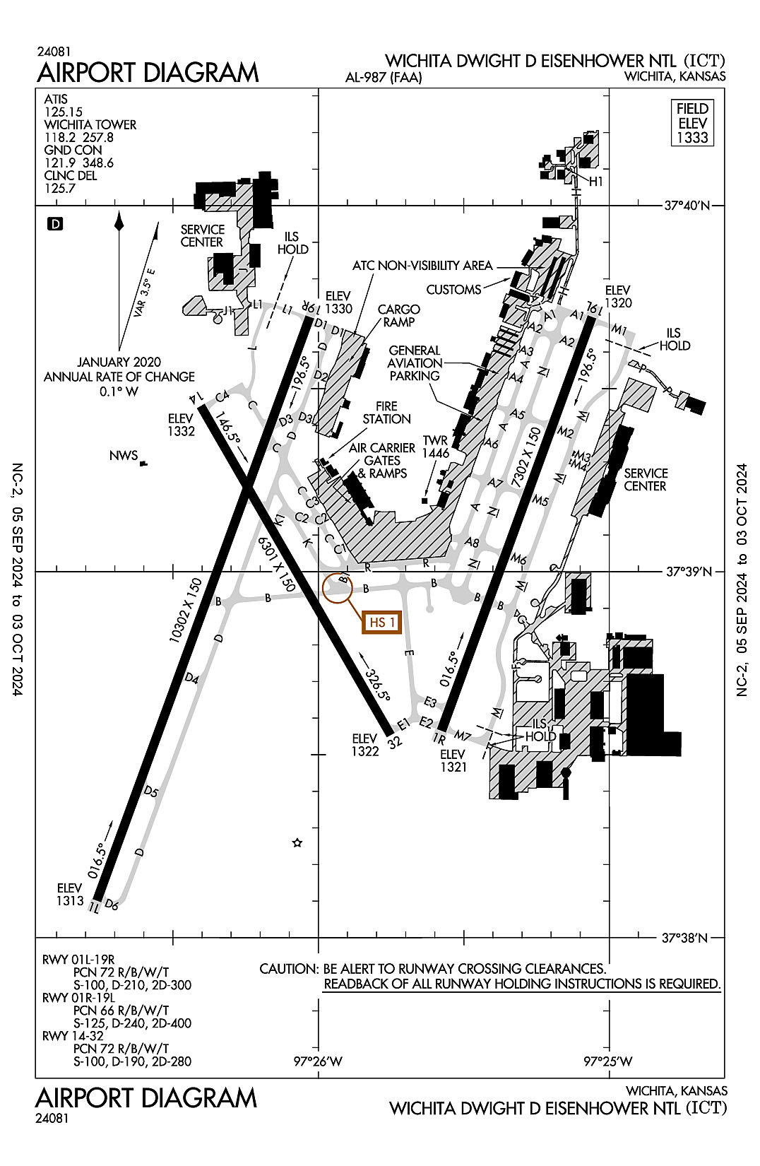
AD 2.2 Aerodrome Geographical and Administrative Data
2.2.1 Reference Point: 37-38-59.829N / 97-25-58.954W
2.2.2 From City: 5 miles SW of WICHITA, KS
2.2.3 Elevation: 1332.6 ft
2.2.5 Magnetic Variation: 4E (2015)
2.2.6 Airport Contact: MR. JESSE ROMO, A.A.E.
2173 AIR CARGO ROAD
WICHITA, KS 67209 (316-946-4700)
2.2.7 Traffic: IFR/VFR
AD 2.3 Attendance Schedule
2.3.1 All Months, All Days, All Hours
AD 2.4 Handling Services and Facilities
2.4.1 Cargo Handling Facilities: YES
2.4.2 Fuel Types: 100LL A
2.4.5 Hangar Space: YES
2.4.6 Repair Facilities: MAJOR
AD 2.6 Rescue and Firefighting Services
2.6.1 Aerodrome Category: Class-I certified on 5/1/1973
2.6.2 Rescue and Firefighting Services: ARFF Index-C
AD 2.12 Runway Physical Characteristics
2.12.1 Designation: 01L
2.12.2 True Bearing: 20
2.12.3 True Dimensions: 10302 ft x 150 ft
2.12.4 PCN: 72 R/B/W/T
2.12.5 Coordinates: 37-38-06.0645N / 97-26-45.5906W
2.12.6 Threshold Elevation: 1312.5
2.12.6 Touchdown Zone Elevation: 1314.1
2.12.1 Designation: 19R
2.12.2 True Bearing: 200
2.12.3 True Dimensions: 10302 ft x 150 ft
2.12.4 PCN: 72 R/B/W/T
2.12.5 Coordinates: 37-39-41.7663N / 97-26-01.7916W
2.12.6 Threshold Elevation: 1329.6
2.12.6 Touchdown Zone Elevation: 1329.7
2.12.1 Designation: 01R
2.12.2 True Bearing: 20
2.12.3 True Dimensions: 7302 ft x 150 ft
2.12.4 PCN: 66 R/B/W/T
2.12.5 Coordinates: 37-38-33.9441N / 97-25-34.6296W
2.12.6 Threshold Elevation: 1321
2.12.6 Touchdown Zone Elevation: 1321.1
2.12.1 Designation: 19L
2.12.2 True Bearing: 200
2.12.3 True Dimensions: 7302 ft x 150 ft
2.12.4 PCN: 66 R/B/W/T
2.12.5 Coordinates: 37-39-41.7709N / 97-25-03.5648W
2.12.6 Threshold Elevation: 1319.8
2.12.6 Touchdown Zone Elevation: 1320.1
2.12.1 Designation: 32
2.12.2 True Bearing: 330
2.12.3 True Dimensions: 6301 ft x 150 ft
2.12.4 PCN: 72 R/B/W/T
2.12.5 Coordinates: 37-38-33.2136N / 97-25-45.1001W
2.12.6 Threshold Elevation: 1321.6
2.12.6 Touchdown Zone Elevation: 1321.8
2.12.1 Designation: 14
2.12.2 True Bearing: 150
2.12.3 True Dimensions: 6301 ft x 150 ft
2.12.4 PCN: 72 R/B/W/T
2.12.5 Coordinates: 37-39-27.162N / 97-26-24.273W
2.12.6 Threshold Elevation: 1332.1
2.12.6 Touchdown Zone Elevation: 1332.6
AD 2.13 Declared Distances
2.13.1 Designation: 01L
2.13.2 Take-off Run Available: 10301
2.13.3 Take-off Distance Available: 10301
2.13.4 Accelerate-Stop Distance Available: 10301
2.13.5 Landing Distance Available: 10301
2.13.1 Designation: 19R
2.13.2 Take-off Run Available: 10301
2.13.3 Take-off Distance Available: 10301
2.13.4 Accelerate-Stop Distance Available: 10301
2.13.5 Landing Distance Available: 10301
2.13.1 Designation: 01R
2.13.2 Take-off Run Available: 7302
2.13.3 Take-off Distance Available: 7302
2.13.4 Accelerate-Stop Distance Available: 7302
2.13.5 Landing Distance Available: 7302
2.13.1 Designation: 19L
2.13.2 Take-off Run Available: 7302
2.13.3 Take-off Distance Available: 7302
2.13.4 Accelerate-Stop Distance Available: 7302
2.13.5 Landing Distance Available: 7302
2.13.1 Designation: 32
2.13.2 Take-off Run Available: 6301
2.13.3 Take-off Distance Available: 6301
2.13.4 Accelerate-Stop Distance Available: 6301
2.13.5 Landing Distance Available: 6301
2.13.1 Designation: 14
2.13.2 Take-off Run Available: 6301
2.13.3 Take-off Distance Available: 6301
2.13.4 Accelerate-Stop Distance Available: 6301
2.13.5 Landing Distance Available: 6301
AD 2.14 Approach and Runway Lighting
2.14.1 Designation: 01L
2.14.2 Approach Lighting System: ALSF2
2.14.4 Visual Approach Slope Indicator System:
2.14.1 Designation: 19R
2.14.2 Approach Lighting System: MALSR
2.14.4 Visual Approach Slope Indicator System:
2.14.1 Designation: 01R
2.14.2 Approach Lighting System: MALSR
2.14.4 Visual Approach Slope Indicator System:
2.14.1 Designation: 19L
2.14.2 Approach Lighting System: MALSR
2.14.4 Visual Approach Slope Indicator System: P4L
2.14.1 Designation: 32
2.14.2 Approach Lighting System:
2.14.4 Visual Approach Slope Indicator System: P4L
2.14.1 Designation: 14
2.14.2 Approach Lighting System:
2.14.4 Visual Approach Slope Indicator System: P4L
AD 2.18 Air Traffic Services Communication Facilities
2.18.1 Service Designation: APCH/P (270-009 BLW 5000 FT & BYD 20 NM)
2.18.3 Channel: 125.5
2.18.5 Hours of Operation: 24
2.18.1 Service Designation: APCH/P (E IAB BLW 5000 FT)
2.18.3 Channel: 269.1
2.18.5 Hours of Operation: 24
2.18.1 Service Designation: APCH/P (270-009 BLW 5000 FT & BYD 20 NM)
2.18.3 Channel: 325.8
2.18.5 Hours of Operation: 24
2.18.1 Service Designation: APCH/P DEP/P (010-190)
2.18.3 Channel: 134.85
2.18.5 Hours of Operation: 24
2.18.1 Service Designation: APCH/P DEP/P (010-190)
2.18.3 Channel: 290.275
2.18.5 Hours of Operation: 24
2.18.1 Service Designation: APCH/P DEP/P IC (191-009)
2.18.3 Channel: 126.7
2.18.5 Hours of Operation: 24
2.18.1 Service Designation: APCH/P DEP/P IC (191-009)
2.18.3 Channel: 353.5
2.18.5 Hours of Operation: 24
2.18.1 Service Designation: APCH/S DEP/S
2.18.3 Channel: 327.1
2.18.5 Hours of Operation: 24
2.18.1 Service Designation: ATIS
2.18.3 Channel: 125.15
2.18.5 Hours of Operation: 24
2.18.1 Service Designation: CD/P
2.18.3 Channel: 125.7
2.18.5 Hours of Operation: 24
2.18.1 Service Designation: CLASS C (191-009)
2.18.3 Channel: 126.7
2.18.5 Hours of Operation: 24
2.18.1 Service Designation: CLASS C (010-190 4000 FT & BLW)
2.18.3 Channel: 134.8
2.18.5 Hours of Operation: 24
2.18.1 Service Designation: CLASS C (010-190 ABV 4000 FT)
2.18.3 Channel: 134.85
2.18.5 Hours of Operation: 24
2.18.1 Service Designation: CLASS C (010-190 ABV 4000 FT)
2.18.3 Channel: 290.275
2.18.5 Hours of Operation: 24
2.18.1 Service Designation: CLASS C (191-009)
2.18.3 Channel: 353.5
2.18.5 Hours of Operation: 24
2.18.1 Service Designation: EMERG
2.18.3 Channel: 121.5
2.18.5 Hours of Operation:
2.18.1 Service Designation: EMERG
2.18.3 Channel: 243
2.18.5 Hours of Operation:
2.18.1 Service Designation: GND/P
2.18.3 Channel: 121.9
2.18.5 Hours of Operation: 24
2.18.1 Service Designation: GND/P
2.18.3 Channel: 348.6
2.18.5 Hours of Operation: 24
2.18.1 Service Designation: LCL/P
2.18.3 Channel: 118.2
2.18.5 Hours of Operation: 24
2.18.1 Service Designation: LCL/P
2.18.3 Channel: 257.8
2.18.5 Hours of Operation: 24
2.18.1 Service Designation: RDR
2.18.3 Channel: 317.425
2.18.5 Hours of Operation:
AD 2.19 Radio Navigation and Landing Aids
2.19.1 ILS Type: Glide Slop for runway 01L. Magnetic variation: 4E
2.19.2 ILS Identification: TWI
2.19.5 Coordinates: 37-38-16.7093N / 97-26-46.0091W
2.19.6 Site Elevation: 1310.5 ft
2.19.1 ILS Type: Inner Marker for runway 01L. Magnetic variation: 4E
2.19.2 ILS Identification: TWI
2.19.5 Coordinates: 37-37-57.139N / 97-26-49.6801W
2.19.6 Site Elevation: 1317.9 ft
2.19.1 ILS Type: Localizer for runway 01L. Magnetic variation: 4E
2.19.2 ILS Identification: TWI
2.19.5 Coordinates: 37-39-51.3411N / 97-25-57.406W
2.19.6 Site Elevation: 1319.7 ft
2.19.1 ILS Type: Outer Marker for runway 01L. Magnetic variation: 4E
2.19.2 ILS Identification: TWI
2.19.5 Coordinates: 37-33-33.9381N / 97-28-51.7772W
2.19.6 Site Elevation: 1311.2 ft
2.19.1 ILS Type: Glide Slop for runway 19R. Magnetic variation: 4E
2.19.2 ILS Identification: HOV
2.19.5 Coordinates: 37-39-33.8636N / 97-26-10.8356W
2.19.6 Site Elevation: 1327.4 ft
2.19.1 ILS Type: Localizer for runway 19R. Magnetic variation: 4E
2.19.2 ILS Identification: HOV
2.19.5 Coordinates: 37-37-54.7075N / 97-26-50.7862W
2.19.6 Site Elevation: 1320.8 ft
2.19.1 ILS Type: Outer Marker for runway 19R. Magnetic variation: 4E
2.19.2 ILS Identification: HOV
2.19.5 Coordinates: 37-44-16.6003N / 97-24-00.9982W
2.19.6 Site Elevation: 1325.3 ft
2.19.1 ILS Type: DME for runway 01R. Magnetic variation: 4E
2.19.2 ILS Identification: ICT
2.19.5 Coordinates: 37-39-52.0431N / 97-25-02.8236W
2.19.6 Site Elevation: 1327.1 ft
2.19.1 ILS Type: Glide Slop for runway 01R. Magnetic variation: 4E
2.19.2 ILS Identification: ICT
2.19.5 Coordinates: 37-38-42.6366N / 97-25-24.6949W
2.19.6 Site Elevation: 1314.7 ft
2.19.1 ILS Type: Localizer for runway 01R. Magnetic variation: 4E
2.19.2 ILS Identification: ICT
2.19.5 Coordinates: 37-39-52.0134N / 97-24-58.8717W
2.19.6 Site Elevation: 1309.6 ft
2.19.1 ILS Type: Outer Marker for runway 01R. Magnetic variation: 4E
2.19.2 ILS Identification: ICT
2.19.5 Coordinates: 37-34-41.4784N / 97-27-21.1454W
2.19.6 Site Elevation: 1315.2 ft
2.19.1 ILS Type: DME for runway 19L. Magnetic variation: 4E
2.19.2 ILS Identification: MVP
2.19.5 Coordinates: 37-38-21.5439N / 97-25-43.3444W
2.19.6 Site Elevation: 1320 ft
2.19.1 ILS Type: Glide Slop for runway 19L. Magnetic variation: 4E
2.19.2 ILS Identification: MVP
2.19.5 Coordinates: 37-39-30.7714N / 97-25-03.1731W
2.19.6 Site Elevation: 1313.6 ft
2.19.1 ILS Type: Localizer for runway 19L. Magnetic variation: 4E
2.19.2 ILS Identification: MVP
2.19.5 Coordinates: 37-38-21.2844N / 97-25-40.4224W
2.19.6 Site Elevation: 1319.3 ft
2.19.1 Navigation Aid Type VORTAC. Magnetic variation: 7E
2.19.2 Navigation Aid Identification: ICT
2.19.5 Coordinates: 37-44-42.9259N / 97-35-01.782W
2.19.6 Site Elevation: 1472 ft
General Remarks:
TWY L AND L1 CLSD TO ACFT WITH WINGSPAN MORE THAN 118.
AIR CARGO RAMP CLSD TO ACFT WINGSPAN MORE THAN 148 FT.
AIRCRAFT ENGINE RUNS ABOVE IDLE NOT APPROVED ON AIRCRAFT PARKING RAMPS.
PPR REQUIRED FOR ACFT CARRYING CLASS 1DIVISION 1.1, 1.2 OR 1.3 EXPLOSIVES AS DEFINED BY 49 CFR 173.50 OR AS AMENDED.
ACFT PARKING BAS CONTACT 132.00 FOR PARKING INSTRUCTIONS PRIOR TO EXITING TWY L1.
TWYS F, G, H, J, P AND ALL ACFT PARKING RAMPS ARE NONMOVEMENT AREAS.
ATCT HAS LTD VIS OF TRML GATES 1 THRU 8, TWY H, AND CUSTOMS PRKG RAMP.
ATTENDED CONTINUOUSLY.
CALL FOR GATE PUSHBACK NOT REQUIRED.
TWY P CLSD TO ACFT WITH WINGSPAN MORE THAN 79.
TWY H CLSD TO ACFT WITH WINGSPAN MORE THAN 79.
MIGRATORY BIRDS ON AND IN VICINITY OF ARPT, ALL QUADS.
FLIGHT NOTIFICATION SERVICE (ADCUS) AVBL.