Alaska
Anchorage, Alaska
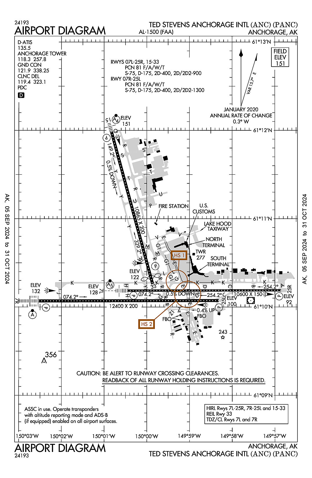
Ted Stevens Anchorage International
ICAO Identifier PANC
Anchorage, AK
Ted Stevens Anchorage Intl
ICAO Identifier PANC
AD 2.2 Aerodrome Geographical and Administrative Data
2.2.1 Reference Point: 61-10-26.705N / 149-59-53.295W
2.2.2 From City: 4 miles SW of ANCHORAGE, AK
2.2.3 Elevation: 151.4 ft
2.2.5 Magnetic Variation: 16E (2020)
2.2.6 Airport Contact: ANGIE SPEAR
BOX 196960
ANCHORAGE, AK 99519 (907-266-2600)
2.2.7 Traffic: IFR/VFR
AD 2.3 Attendance Schedule
2.3.1 All Months, All Days, All Hours
AD 2.4 Handling Services and Facilities
2.4.1 Cargo Handling Facilities: YES
2.4.2 Fuel Types: 100 100LL A A1
2.4.5 Hangar Space: YES
2.4.6 Repair Facilities: MAJOR
AD 2.6 Rescue and Firefighting Services
2.6.1 Aerodrome Category: Class-I certified on 4/1/2005
2.6.2 Rescue and Firefighting Services: ARFF Index-E
AD 2.12 Runway Physical Characteristics
2.12.1 Designation: 07L
2.12.2 True Bearing: 90
2.12.3 True Dimensions: 10600 ft x 150 ft
2.12.4 PCN: 81 F/A/W/T
2.12.5 Coordinates: 61-10-11.1539N / 150-00-29.9998W
2.12.6 Threshold Elevation: 127.6
2.12.6 Touchdown Zone Elevation: 128.2
2.12.1 Designation: 25R
2.12.2 True Bearing: 270
2.12.3 True Dimensions: 10600 ft x 150 ft
2.12.4 PCN: 81 F/A/W/T
2.12.5 Coordinates: 61-10-11.3202N / 149-56-53.8826W
2.12.6 Threshold Elevation: 91.5
2.12.6 Touchdown Zone Elevation: 91.8
2.12.1 Designation: 07R
2.12.2 True Bearing: 90
2.12.3 True Dimensions: 12400 ft x 200 ft
2.12.4 PCN: 81 F/A/W/T
2.12.5 Coordinates: 61-10-04.1216N / 150-02-34.3367W
2.12.6 Threshold Elevation: 131.7
2.12.6 Touchdown Zone Elevation: 131.7
2.12.1 Designation: 25L
2.12.2 True Bearing: 270
2.12.3 True Dimensions: 12400 ft x 200 ft
2.12.4 PCN: 81 F/A/W/T
2.12.5 Coordinates: 61-10-04.3722N / 149-58-21.535W
2.12.6 Threshold Elevation: 100.4
2.12.6 Touchdown Zone Elevation: 114.6
2.12.1 Designation: 15
2.12.2 True Bearing: 165
2.12.3 True Dimensions: 10865 ft x 200 ft
2.12.4 PCN: 81 F/A/W/T
2.12.5 Coordinates: 61-11-59.03N / 150-00-52.31W
2.12.6 Threshold Elevation: 151.3
2.12.6 Touchdown Zone Elevation: 151.4
2.12.1 Designation: 33
2.12.2 True Bearing: 345
2.12.3 True Dimensions: 10865 ft x 200 ft
2.12.4 PCN: 81 F/A/W/T
2.12.5 Coordinates: 61-10-15.75N / 149-59-54.49W
2.12.6 Threshold Elevation: 121.7
2.12.6 Touchdown Zone Elevation: 120.8
AD 2.13 Declared Distances
2.13.1 Designation: 07L
2.13.2 Take-off Run Available: 10600
2.13.3 Take-off Distance Available: 10600
2.13.4 Accelerate-Stop Distance Available: 10600
2.13.5 Landing Distance Available: 10600
2.13.1 Designation: 25R
2.13.2 Take-off Run Available: 10600
2.13.3 Take-off Distance Available: 10600
2.13.4 Accelerate-Stop Distance Available: 10600
2.13.5 Landing Distance Available: 10600
2.13.1 Designation: 07R
2.13.2 Take-off Run Available: 10900
2.13.3 Take-off Distance Available: 10900
2.13.4 Accelerate-Stop Distance Available: 10900
2.13.5 Landing Distance Available: 12400
2.13.1 Designation: 25L
2.13.2 Take-off Run Available: 12400
2.13.3 Take-off Distance Available: 12400
2.13.4 Accelerate-Stop Distance Available: 12000
2.13.5 Landing Distance Available: 12000
2.13.1 Designation: 15
2.13.2 Take-off Run Available: 10865
2.13.3 Take-off Distance Available: 10865
2.13.4 Accelerate-Stop Distance Available: 10000
2.13.5 Landing Distance Available: 10000
2.13.1 Designation: 33
2.13.2 Take-off Run Available: 10865
2.13.3 Take-off Distance Available: 11965
2.13.4 Accelerate-Stop Distance Available: 10865
2.13.5 Landing Distance Available: 10400
AD 2.14 Approach and Runway Lighting
2.14.1 Designation: 07L
2.14.2 Approach Lighting System: MALSR
2.14.4 Visual Approach Slope Indicator System: P4R
2.14.1 Designation: 25R
2.14.2 Approach Lighting System:
2.14.4 Visual Approach Slope Indicator System: P4L
2.14.1 Designation: 07R
2.14.2 Approach Lighting System: ALSF2
2.14.4 Visual Approach Slope Indicator System: P4R
2.14.1 Designation: 25L
2.14.2 Approach Lighting System:
2.14.4 Visual Approach Slope Indicator System: P4L
2.14.1 Designation: 15
2.14.2 Approach Lighting System: MALSF
2.14.4 Visual Approach Slope Indicator System: P4R
2.14.1 Designation: 33
2.14.2 Approach Lighting System:
2.14.4 Visual Approach Slope Indicator System: P4R
AD 2.18 Air Traffic Services Communication Facilities
2.18.1 Service Designation: CD/P
2.18.3 Channel: 119.4
2.18.5 Hours of Operation: 24
2.18.1 Service Designation: CD/P
2.18.3 Channel: 323.1
2.18.5 Hours of Operation: 24
2.18.1 Service Designation: CD/S
2.18.3 Channel: 128.65
2.18.5 Hours of Operation: 24
2.18.1 Service Designation: D-ATIS
2.18.3 Channel: 135.5
2.18.5 Hours of Operation: 24
2.18.1 Service Designation: EMERG
2.18.3 Channel: 121.5
2.18.5 Hours of Operation:
2.18.1 Service Designation: EMERG
2.18.3 Channel: 243
2.18.5 Hours of Operation:
2.18.1 Service Designation: GND/P
2.18.3 Channel: 121.9
2.18.5 Hours of Operation: 24
2.18.1 Service Designation: GND/P
2.18.3 Channel: 338.25
2.18.5 Hours of Operation: 24
2.18.1 Service Designation: LCL/P
2.18.3 Channel: 118.3
2.18.5 Hours of Operation: 24
2.18.1 Service Designation: LCL/P
2.18.3 Channel: 257.8
2.18.5 Hours of Operation: 24
AD 2.19 Radio Navigation and Landing Aids
2.19.1 ILS Type: DME for runway 07L. Magnetic variation: 16E
2.19.2 ILS Identification: TGN
2.19.5 Coordinates: 61-10-14.0636N / 149-56-33.0327W
2.19.6 Site Elevation: 105.5 ft
2.19.1 ILS Type: Glide Slop for runway 07L. Magnetic variation: 16E
2.19.2 ILS Identification: TGN
2.19.5 Coordinates: 61-10-13.93N / 150-00-09.62W
2.19.6 Site Elevation: 122.8 ft
2.19.1 ILS Type: Localizer for runway 07L. Magnetic variation: 16E
2.19.2 ILS Identification: TGN
2.19.5 Coordinates: 61-10-11.3329N / 149-56-32.6534W
2.19.6 Site Elevation: 84.7 ft
2.19.1 ILS Type: DME for runway 07R. Magnetic variation: 16E
2.19.2 ILS Identification: ANC
2.19.5 Coordinates: 61-10-02.0211N / 149-57-58.3996W
2.19.6 Site Elevation: 112 ft
2.19.1 ILS Type: Glide Slop for runway 07R. Magnetic variation: 16E
2.19.2 ILS Identification: ANC
2.19.5 Coordinates: 61-10-08.1823N / 150-02-12.4572W
2.19.6 Site Elevation: 124.9 ft
2.19.1 ILS Type: Localizer for runway 07R. Magnetic variation: 16E
2.19.2 ILS Identification: ANC
2.19.5 Coordinates: 61-10-04.3906N / 149-57-55.495W
2.19.6 Site Elevation: 97.7 ft
2.19.1 ILS Type: DME for runway 15. Magnetic variation: 16E
2.19.2 ILS Identification: BSC
2.19.5 Coordinates: 61-10-00.0069N / 149-59-40.3379W
2.19.6 Site Elevation: 134.7 ft
2.19.1 ILS Type: Glide Slop for runway 15. Magnetic variation: 16E
2.19.2 ILS Identification: BSC
2.19.5 Coordinates: 61-11-46.76N / 150-00-54.42W
2.19.6 Site Elevation: 151.3 ft
2.19.1 ILS Type: Localizer for runway 15. Magnetic variation: 16E
2.19.2 ILS Identification: BSC
2.19.5 Coordinates: 61-09-59.9158N / 149-59-45.6352W
2.19.6 Site Elevation: 120.9 ft
General Remarks:
NON-RADIO NIGHT OPS NA; NON-PARROT OPS 1 HR PPR; NON-RADIO OPS PPR; MUST PRVD ETA & REMAIN WI 15 MIN - ATCT 907-271-2700 WKDAYS 0730-1600; AFT HR & HOL - FAA 907-271-5936.
NOISE SENSITIVE AREA S & E; RWY 07R, 07L, 15 TBJT/TURBOFAN DEP EMPLOY FAA CLOSE IN NADP OR ICAO PROC B NADP WHEN SAFETY PERMITS; INFO - AMGR.
R TURN OUT OF RAMP PRKG R-2 THRU R-4 NA.
COMPASS CLBR PAD N/A.
BIRDS INVOF ARPT SPRING - FALL.
TWY V, SCTY GATE E OF TWY E - PCL 121.75 5 TIMES; TWY H-2, LAKESHORE TWY GATES - PCL 121.75 3 TIMES; IF INOP ALLOW 30 SEC RESET & NOTIFY LHD OPS - 907-266-2600.
PTNS OF TWY K BTN TWY H & J NOT VIS FM ATCT.
PPR FOR GND TIME GTR THAN 4 HR AT ARPT CTL SPOTS; APVL REQ 48 HR PRIOR TO DEP FOR ANC - GATE MGMT 907 266-2633 OR EMAIL: DOT.AIA.OPS.GATEMANAGEMENT@ALASKA.GOV.
TSNT MIL PPR.
TWY V RSTRD TO 12500 LB OR LESS; SUBJECT TO JET BLAST W OF TWY E.
489 FT UNLGTD TWR 2.5 MI NE.
ANCHORAGE WX CAMERA AVBL ON INTERNET AT HTTPS://WEATHERCAMS.FAA.GOV.
FLT PLANNING IN ANCHORAGE BOWL AREA - RCO 122.55.
FAA RAMP PPR WITH ANC FIFO MON-FRI 0600-1430 - 135.85 OR 907-271-2414 OR AVN 405-954-9780.
COLD TEMPERATURE AIRPORT. ALTITUDE CORRECTION REQUIRED AT OR BELOW -21C.
WSO - 907-266-5105.
P RAMP PRKG SPOTS P1/2/3 JET BLAST HAZ; EXIT USING MIN THRUST REQ.
Anchorage, Alaska
Elmendorf AFB
ICAO Identifier PAED
Anchorage, AK
Elmendorf AFB
ICAO Identifier PAED
AD 2.2 Aerodrome Geographical and Administrative Data
2.2.1 Reference Point: 61-15-04.8715N / 149-48-23.4924W
2.2.2 From City: 3 miles NE of ANCHORAGE, AK
2.2.3 Elevation: 213 ft
2.2.5 Magnetic Variation: 18E (2015)
2.2.6 Airport Contact: AIRFIELD MGR
300SS/DOFJ
ELMENDORF AFB, AK 99506 (907-552-2444)
2.2.7 Traffic: IFR/VFR
AD 2.3 Attendance Schedule
2.3.1 All Months, All Days, All Hours
AD 2.4 Handling Services and Facilities
2.4.1 Cargo Handling Facilities: YES
2.4.2 Fuel Types: J8
2.4.5 Hangar Space:
2.4.6 Repair Facilities: None
AD 2.6 Rescue and Firefighting Services
2.6.1 Aerodrome Category: None
2.6.2 Rescue and Firefighting Services: None
AD 2.12 Runway Physical Characteristics
2.12.1 Designation: 06
2.12.2 True Bearing: 80
2.12.3 True Dimensions: 10000 ft x 200 ft
2.12.4 PCN: 58 R/B/W/T
2.12.5 Coordinates: 61-14-55.08N / 149-50-39.34W
2.12.6 Threshold Elevation: 174.5
2.12.6 Touchdown Zone Elevation: 174.5
2.12.1 Designation: 24
2.12.2 True Bearing: 260
2.12.3 True Dimensions: 10000 ft x 200 ft
2.12.4 PCN: 58 R/B/W/T
2.12.5 Coordinates: 61-15-12.16N / 149-47-18.02W
2.12.6 Threshold Elevation: 201.3
2.12.6 Touchdown Zone Elevation: 201.3
2.12.1 Designation: 16
2.12.2 True Bearing: 180
2.12.3 True Dimensions: 7493 ft x 150 ft
2.12.4 PCN: 55 F/A/W/T
2.12.5 Coordinates: 61-15-43.43N / 149-47-36.52W
2.12.6 Threshold Elevation: 212.5
2.12.6 Touchdown Zone Elevation: 212.4
2.12.1 Designation: 34
2.12.2 True Bearing: 360
2.12.3 True Dimensions: 7493 ft x 150 ft
2.12.4 PCN: 55 F/A/W/T
2.12.5 Coordinates: 61-14-29.64N / 149-47-36.57W
2.12.6 Threshold Elevation: 184.9
2.12.6 Touchdown Zone Elevation: 194.1
AD 2.13 Declared Distances
2.13.1 Designation: 06
2.13.2 Take-off Run Available:
2.13.3 Take-off Distance Available:
2.13.4 Accelerate-Stop Distance Available:
2.13.5 Landing Distance Available:
2.13.1 Designation: 24
2.13.2 Take-off Run Available:
2.13.3 Take-off Distance Available:
2.13.4 Accelerate-Stop Distance Available:
2.13.5 Landing Distance Available:
2.13.1 Designation: 16
2.13.2 Take-off Run Available:
2.13.3 Take-off Distance Available:
2.13.4 Accelerate-Stop Distance Available:
2.13.5 Landing Distance Available:
2.13.1 Designation: 34
2.13.2 Take-off Run Available:
2.13.3 Take-off Distance Available:
2.13.4 Accelerate-Stop Distance Available:
2.13.5 Landing Distance Available:
AD 2.14 Approach and Runway Lighting
2.14.1 Designation: 06
2.14.2 Approach Lighting System: ALSF1
2.14.4 Visual Approach Slope Indicator System: P4L
2.14.1 Designation: 24
2.14.2 Approach Lighting System:
2.14.4 Visual Approach Slope Indicator System: P4L
2.14.1 Designation: 16
2.14.2 Approach Lighting System:
2.14.4 Visual Approach Slope Indicator System: P4L
2.14.1 Designation: 34
2.14.2 Approach Lighting System:
2.14.4 Visual Approach Slope Indicator System: P4L
AD 2.18 Air Traffic Services Communication Facilities
2.18.1 Service Designation: ATIS
2.18.3 Channel: 124.3
2.18.5 Hours of Operation: 0700-2300
2.18.1 Service Designation: ATIS
2.18.3 Channel: 273.5
2.18.5 Hours of Operation: 0700-2300
2.18.1 Service Designation: CD/P
2.18.3 Channel: 128.8
2.18.5 Hours of Operation: 24
2.18.1 Service Designation: CD/P
2.18.3 Channel: 306.925
2.18.5 Hours of Operation: 24
2.18.1 Service Designation: GND/P
2.18.3 Channel: 121.8
2.18.5 Hours of Operation: 24
2.18.1 Service Designation: GND/P
2.18.3 Channel: 275.8
2.18.5 Hours of Operation: 24
2.18.1 Service Designation: LCL/P
2.18.3 Channel: 127.2
2.18.5 Hours of Operation: 24
2.18.1 Service Designation: LCL/P
2.18.3 Channel: 352.05
2.18.5 Hours of Operation: 24
2.18.1 Service Designation: OPS (11AF RESCUE COORD CNTR)
2.18.3 Channel: 123.1
2.18.5 Hours of Operation:
2.18.1 Service Designation: OPS (11AF RESCUE COORD CNTR)
2.18.3 Channel: 282.8
2.18.5 Hours of Operation:
2.18.1 Service Designation: OPS (11AF COMD CEN)
2.18.3 Channel: 381
2.18.5 Hours of Operation:
2.18.1 Service Designation: OPS (ARTIC WARRIOR OPS)
2.18.3 Channel: 381
2.18.5 Hours of Operation:
2.18.1 Service Designation: PMSV METRO
2.18.3 Channel: 346.6
2.18.5 Hours of Operation:
2.18.1 Service Designation: PTD
2.18.3 Channel: 134.8
2.18.5 Hours of Operation:
2.18.1 Service Designation: PTD
2.18.3 Channel: 372.2
2.18.5 Hours of Operation:
AD 2.19 Radio Navigation and Landing Aids
2.19.1 ILS Type: Glide Slop for runway 06. Magnetic variation: 18E
2.19.2 ILS Identification: EDF
2.19.5 Coordinates: 61-15-01.2N / 149-50-17W
2.19.6 Site Elevation: 169.2 ft
2.19.1 ILS Type: Localizer for runway 06. Magnetic variation: 18E
2.19.2 ILS Identification: EDF
2.19.5 Coordinates: 61-15-14.33N / 149-46-52.29W
2.19.6 Site Elevation: 212.3 ft
2.19.1 Navigation Aid Type TACAN. Magnetic variation: 18E
2.19.2 Navigation Aid Identification: EDF
2.19.5 Coordinates: 61-15-18.03N / 149-46-09.03W
2.19.6 Site Elevation: 226.2 ft
General Remarks:
H24 WX - D317-552-4903/4397/C907-552-4903/4397.
LMTD WKEND MAINT SVC.
CHANGE JET ACFT STARTING UNITS (JASU) TO, (A/M32A-86), MC-1A), (MC-2A), (AM32A-60A). (AM32-95)150 +/-5 LBS/MIN (2055 +/-68CFM) AT 51 +/-02 PSIA. LASS 150 +/-5 LBS/MIN @ 49 +/-2 PSIA.
LCL SORTIES OR DEPLOYING TO OR OUT OF ELMENDORF AFB MUST HAVE MAINT PSNL REQ TO CMPLT OPS; INCLG DE-ICE PSNL DURG COLD WX. DEPLOYED ACFT TRANS ALERT SUPPORT NA BYD INITIAL BLOCK IN.
SUBMIT PPR FORM IN THE PAED GIANT REPORT STIF TO BASEOPS3@US.AF.MIL NO EARLIER THAN 30 DAYS & NO LATER THAN 48 HR PRIOR TO ARR. PPR ISSUED NO EARLIER THAN 7 DAYS PRIOR TO ARR.
DURG VMC DEP/MISSED APCHS/GO AROUNDS; ACFT SHALL MNTN AT OR BLW 1200 FT MLS UNTIL DEP END OF RWY 06.
NON-AMC RQRG 732 AMS MAINT SVC EXP PSBL DELAY.
RCR/RSC & FLD RCR - ATCT. RWY COND CODE & FICON NOT RPTD.
OIL: O-123, O-128, O-133, O-148, O-156, JOAP.
NORMAL BARRIER CONFIGURATION DURG FTR FLY WINDOW LEAVES 5675 FT BTW CABLES ON RWY 06/24, OUTSIDE OF FTR FLY WINDOWS THERE IS 7658 FT BTW CABLES.
ACFT REQ CABLES DE-RIGGED CTC BASE OPS 24 HR PRIOR TO ARR OR REQ PRIOR TO PPR ISSUED.
AIRFIELD MGMT COMSEC STORAGE NA; COMSEC STORAGE - COMMAND POST D317-552-3000.
PREVENTIVE MAINT: TACAN WED & FRI 1600-1700Z; ILS TUE & THU 1500-1700Z; PAR SAT-SUN 1800-2000Z; ASR SAT-SUN 2000-2200.
FQT ACT IN R2203; WHEN UNA TO AVOID CTC ATCT.
JOAP, JOINT OIL ANALYSIS PROGRAM AVBL. LHNIT, LOW & HIGH PRES NITROGEN SVCG AVBL. JOAP & LOW & HIGH PRES NITROGEN SVC DURG DUTY HOURS; AFT HR ON REQ. DE-ICE, TYPE 1 DE-ICE LIFTOFF P-88; TYPE 4 ANTI-ICE CLARIANT SAFEWING MP-LAUNCH.
CTN: UNLGT TRRN 0 FT AGL/341 FT MSL 1909 FT PRIOR TO THR 1914 FT R OF COURSE.
CUST & AG INSP RQR TO CTC BASE OPS AT LEAST 90 MIN PRIOR TO ARR.
TRAN ALERT SVC LMTD TO POL SVC, INTAKE, MAGNETIC CHIP DETECTOR & EOR INSP.
HOLD SHORT LINE SIGNS NA ON INTERSECTING RWYS.
CTN: RIDGE EXTDG FM 260-020 DEG 1-2 MI FM TWR PREVENTS FOG OBS OVR KNIK ARM. VIS MAY DROP RAPIDLY AS FOG POURS OVR RIDGE.
TWY N2 & N5 CLSD.
UNA TO MEET R2203 DEP RSTRNS ADVISE ATC PRIOR; CSDR RWY 24 DEP. SEE ATC NOTES IN GIANT RPRT.
QUIET HR 0630-1400Z WKDAY; 0630-1600Z WKEND & HOL; AMC ACFT EXEMPT.
HGR SPACE & WARM STORAGE LMTD OCT-MAY.
IFF SVC AVBL.
CTN: IFR OPS BTW 1500-2000 MSL FM BGQ 092/10 INTO R2203-EDF 320/07 INVOF BIG LAKE, PALMER, BIRCHWOOD, GOOSEBAY & WASILLA AK; MON-SAT 0300-0800Z++ & TUES & THU 1800-2200Z++.
EXC ELMENDORF MAJCOM EXER, DEPLOYED OR STAGED UNITS CTC 3 WG SKED D317-552-2406 OR C907-552-2406 ASAP FOR LCL AREA BRIEFING, MAINT SPONSORSHIP & VISITING UNIT SMTN REQ FORM FOR 3 OG/CC APVL PRIOR TO LCL OPS.
FTR ARR EXP RDCD SEPN; SAME TYPE ACFT & DALGT 3000 FT; DISSIMILAR ACFT &/OR NGT 6000 FT; AHD/BHND FRMN LDG 6000 FT.
NVD OPS RWY 06/24 MON-FRI 0400-1000Z++.
SPEC ATC RULES FAR PART 93; SEE REG NOTICES IN SUPPL.
DV SPOTS 1 & 3 LMTD TO WINGSPANS 136 FT OR LESS.
PPR NON JBER ASGND ACFT EXC LCL TRNG NON-EXPLOSIVE LADEN AMCC ACFT. NON-FUNDED USTRANSCOM, AMC, 18AF OR MOV PRIORITY 3A1 OR BLW PPR BFR ARR - AMGR.
AMC ASGND MSN ACFT EXP MAINT SVC BY 732 AMS.
MNTN IDLE PWR ON OUTBOARD ENG DURG TAX.
FLUID: PRESAIR & NITROGEN-LHNIT.
ELBOW END OF RWY & TWY R RSTRD TO FIGHTERS ONLY WHEN FIGHTERS STAGED ON ELBOW END OF RWY.
Cold Bay, Alaska
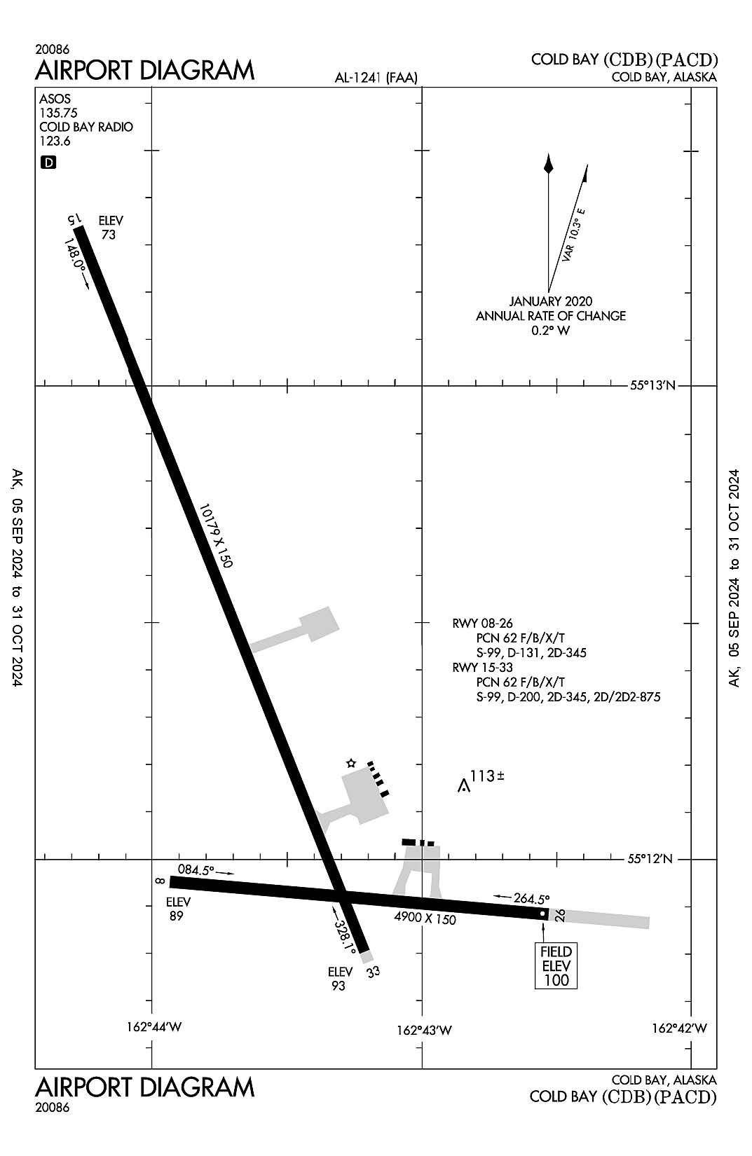
Cold Bay
ICAO Identifier PACD
Cold Bay, AK
Cold Bay
ICAO Identifier PACD
AD 2.2 Aerodrome Geographical and Administrative Data
2.2.1 Reference Point: 55-12-21.3N / 162-43-34.5W
2.2.2 From City: 0 miles N of COLD BAY, AK
2.2.3 Elevation: 99.5 ft
2.2.5 Magnetic Variation: 12E (2015)
2.2.6 Airport Contact: HAROLD KREMER
BOX 97
COLD BAY, AK 99571 (907-532-5000)
2.2.7 Traffic: IFR/VFR
AD 2.3 Attendance Schedule
2.3.1 All Months, MON - SAT Days, 0700 - 1800 Hours
AD 2.4 Handling Services and Facilities
2.4.1 Cargo Handling Facilities: YES
2.4.2 Fuel Types: 100LL A
2.4.5 Hangar Space: YES
2.4.6 Repair Facilities: None
AD 2.6 Rescue and Firefighting Services
2.6.1 Aerodrome Category: Class-I certified on 4/1/2005
2.6.2 Rescue and Firefighting Services: ARFF Index-B
AD 2.12 Runway Physical Characteristics
2.12.1 Designation: 08
2.12.2 True Bearing: 95
2.12.3 True Dimensions: 4900 ft x 150 ft
2.12.4 PCN: 62 F/B/X/T
2.12.5 Coordinates: 55-11-57.1589N / 162-43-56.7308W
2.12.6 Threshold Elevation: 88.9
2.12.6 Touchdown Zone Elevation: 95.2
2.12.1 Designation: 26
2.12.2 True Bearing: 275
2.12.3 True Dimensions: 4900 ft x 150 ft
2.12.4 PCN: 62 F/B/X/T
2.12.5 Coordinates: 55-11-53.1425N / 162-42-32.588W
2.12.6 Threshold Elevation: 99.5
2.12.6 Touchdown Zone Elevation: 99.5
2.12.1 Designation: 15
2.12.2 True Bearing: 158
2.12.3 True Dimensions: 10179 ft x 150 ft
2.12.4 PCN: 62 F/B/X/T
2.12.5 Coordinates: 55-13-20.4998N / 162-44-16.4235W
2.12.6 Threshold Elevation: 72.5
2.12.6 Touchdown Zone Elevation: 75
2.12.1 Designation: 33
2.12.2 True Bearing: 338
2.12.3 True Dimensions: 10179 ft x 150 ft
2.12.4 PCN: 62 F/B/X/T
2.12.5 Coordinates: 55-11-47.2428N / 162-43-11.707W
2.12.6 Threshold Elevation: 93.3
2.12.6 Touchdown Zone Elevation: 93.4
AD 2.13 Declared Distances
2.13.1 Designation: 08
2.13.2 Take-off Run Available: 4900
2.13.3 Take-off Distance Available: 4900
2.13.4 Accelerate-Stop Distance Available: 4900
2.13.5 Landing Distance Available: 4900
2.13.1 Designation: 26
2.13.2 Take-off Run Available: 4900
2.13.3 Take-off Distance Available: 4900
2.13.4 Accelerate-Stop Distance Available: 4900
2.13.5 Landing Distance Available: 4900
2.13.1 Designation: 15
2.13.2 Take-off Run Available: 10179
2.13.3 Take-off Distance Available: 10179
2.13.4 Accelerate-Stop Distance Available: 10179
2.13.5 Landing Distance Available: 10179
2.13.1 Designation: 33
2.13.2 Take-off Run Available: 10179
2.13.3 Take-off Distance Available: 10179
2.13.4 Accelerate-Stop Distance Available: 10179
2.13.5 Landing Distance Available: 10179
AD 2.14 Approach and Runway Lighting
2.14.1 Designation: 08
2.14.2 Approach Lighting System:
2.14.4 Visual Approach Slope Indicator System: P4L
2.14.1 Designation: 26
2.14.2 Approach Lighting System:
2.14.4 Visual Approach Slope Indicator System: P4L
2.14.1 Designation: 15
2.14.2 Approach Lighting System: MALSR
2.14.4 Visual Approach Slope Indicator System:
2.14.1 Designation: 33
2.14.2 Approach Lighting System:
2.14.4 Visual Approach Slope Indicator System: P4L
AD 2.18 Air Traffic Services Communication Facilities
AD 2.19 Radio Navigation and Landing Aids
2.19.1 ILS Type: Glide Slop for runway 15. Magnetic variation: 12E
2.19.2 ILS Identification: CDB
2.19.5 Coordinates: 55-13-12.7692N / 162-44-03.6464W
2.19.6 Site Elevation: 71 ft
2.19.1 ILS Type: Localizer for runway 15. Magnetic variation: 12E
2.19.2 ILS Identification: CDB
2.19.5 Coordinates: 55-11-40.9813N / 162-43-07.3592W
2.19.6 Site Elevation: 95.9 ft
2.19.1 Navigation Aid Type VORTAC. Magnetic variation: 10E
2.19.2 Navigation Aid Identification: CDB
2.19.5 Coordinates: 55-16-02.2606N / 162-46-26.3866W
2.19.6 Site Elevation: 98.5 ft
General Remarks:
PERSONNEL & EQUIP ON RWY.
SNOW, ICE REMOVAL & ARPT HAZ RPRTG DURG DUTY HR UNLESS PRIOR ARNGMT IN WRITING - AMGR.
ARPT SAND LRGR GRADE THAN FAA RCMDD/SEE AC150/5200-30.
NWS BALLOON LAUNCH FAC LCTD ON ARPT; SEE INSIDE BACK COVER FOR DETAILS.
WX CAMERA AVBL - HTTPS://WEATHERCAMS.FAA.GOV
NO CUSTOMS AVBL; 24-48 HR WRITTEN PPR FOR FOREIGN ARR RFLG STOPS - FAX 907-271-2684 OR 907-271-2686.
UNLGTD TWR 0.4 NM N; UNLGTD TWR 0.9 NM S; UNLGTD TWR 4.8 NM NW.
BRAKELOCK TURNS NA.
ROTG BCN UNMON WHEN FSS UNMANNED.
CFR INDEX B; MAY BE REDUCED FOR ACFT LESS THAN 90 FT.
BIRDS INVOF ALL RWY APCH ENDS.
Fairbanks, Alaska
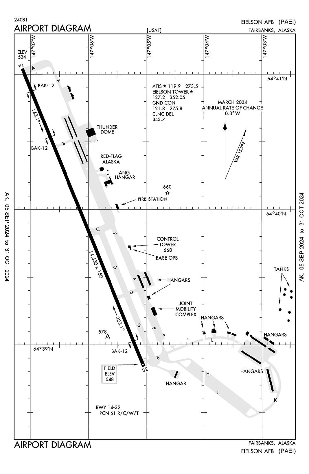
Eielson AFB
ICAO Identifier PAEI
Fairbanks, AK
Eielson AFB
ICAO Identifier PAEI
AD 2.2 Aerodrome Geographical and Administrative Data
2.2.1 Reference Point: 64-39-56.303N / 147-06-05.149W
2.2.2 From City: 17 miles SE of FAIRBANKS, AK
2.2.3 Elevation: 547.5 ft
2.2.5 Magnetic Variation: 19E (2015)
2.2.6 Airport Contact: CHIEF AIRFIELD MANAGEMENT
343 CSG/OTM
EIELSON AFB, AK 99702 (907-377-3201)
2.2.7 Traffic: IFR/VFR
AD 2.3 Attendance Schedule
2.3.1 All Months, All Days, 1600-0800Z++ Hours
AD 2.4 Handling Services and Facilities
2.4.1 Cargo Handling Facilities: NO
2.4.2 Fuel Types:
2.4.5 Hangar Space: YES
2.4.6 Repair Facilities: None
AD 2.6 Rescue and Firefighting Services
2.6.1 Aerodrome Category: None
2.6.2 Rescue and Firefighting Services: None
AD 2.12 Runway Physical Characteristics
2.12.1 Designation: 32
2.12.2 True Bearing: 339
2.12.3 True Dimensions: 14530 ft x 150 ft
2.12.4 PCN: 61 R/C/W/T
2.12.5 Coordinates: 64-38-49.47N / 147-05-05.86W
2.12.6 Threshold Elevation: 547.5
2.12.6 Touchdown Zone Elevation: 547.5
2.12.1 Designation: 14
2.12.2 True Bearing: 159
2.12.3 True Dimensions: 14530 ft x 150 ft
2.12.4 PCN: 61 R/C/W/T
2.12.5 Coordinates: 64-41-03.13N / 147-07-04.52W
2.12.6 Threshold Elevation: 533.8
2.12.6 Touchdown Zone Elevation: 536.7
AD 2.13 Declared Distances
2.13.1 Designation: 32
2.13.2 Take-off Run Available:
2.13.3 Take-off Distance Available:
2.13.4 Accelerate-Stop Distance Available:
2.13.5 Landing Distance Available:
2.13.1 Designation: 14
2.13.2 Take-off Run Available:
2.13.3 Take-off Distance Available:
2.13.4 Accelerate-Stop Distance Available:
2.13.5 Landing Distance Available:
AD 2.14 Approach and Runway Lighting
2.14.1 Designation: 32
2.14.2 Approach Lighting System: ALSF1
2.14.4 Visual Approach Slope Indicator System: P4L
2.14.1 Designation: 14
2.14.2 Approach Lighting System: ALSF1
2.14.4 Visual Approach Slope Indicator System: P4L
AD 2.18 Air Traffic Services Communication Facilities
2.18.1 Service Designation: ATIS
2.18.3 Channel: 119.9
2.18.5 Hours of Operation: 1600-0800Z++
2.18.1 Service Designation: ATIS
2.18.3 Channel: 273.5
2.18.5 Hours of Operation: 1600-0800Z++
2.18.1 Service Designation: CD/P
2.18.3 Channel: 343.7
2.18.5 Hours of Operation: 1600-0800Z++
2.18.1 Service Designation: COMD POST (IGLOO OPS)
2.18.3 Channel: 259.5
2.18.5 Hours of Operation:
2.18.1 Service Designation: COMD POST (IGLOO OPS, HAVE QUICK)
2.18.3 Channel: 289.4
2.18.5 Hours of Operation:
2.18.1 Service Designation: GND/P
2.18.3 Channel: 121.8
2.18.5 Hours of Operation: 1600-0800Z++
2.18.1 Service Designation: GND/P
2.18.3 Channel: 275.8
2.18.5 Hours of Operation: 1600-0800Z++
2.18.1 Service Designation: LCL/P
2.18.3 Channel: 127.2
2.18.5 Hours of Operation: 1600-0800Z++
2.18.1 Service Designation: LCL/P
2.18.3 Channel: 352.05
2.18.5 Hours of Operation: 1600-0800Z++
2.18.1 Service Designation: OPS (SOURDOUGH)
2.18.3 Channel: 139.6
2.18.5 Hours of Operation:
2.18.1 Service Designation: OPS (168 ANG OPS)
2.18.3 Channel: 238.3
2.18.5 Hours of Operation:
2.18.1 Service Designation: OPS (168 ANG OPS)
2.18.3 Channel: 293.6
2.18.5 Hours of Operation:
2.18.1 Service Designation: OPS (SOURDOUGH)
2.18.3 Channel: 359.15
2.18.5 Hours of Operation:
2.18.1 Service Designation: PTD
2.18.3 Channel: 139.3
2.18.5 Hours of Operation:
2.18.1 Service Designation: PTD
2.18.3 Channel: 372.2
2.18.5 Hours of Operation:
2.18.1 Service Designation: RANGE CTL (SUAIS RADIO)
2.18.3 Channel: 125.3
2.18.5 Hours of Operation:
2.18.1 Service Designation: SFA
2.18.3 Channel: 118.6
2.18.5 Hours of Operation:
2.18.1 Service Designation: SFA
2.18.3 Channel: 259.1
2.18.5 Hours of Operation:
2.18.1 Service Designation: SFA
2.18.3 Channel: 318.2
2.18.5 Hours of Operation:
2.18.1 Service Designation: SFA
2.18.3 Channel: 320.1
2.18.5 Hours of Operation:
2.18.1 Service Designation: SFA
2.18.3 Channel: 324.3
2.18.5 Hours of Operation:
AD 2.19 Radio Navigation and Landing Aids
2.19.1 ILS Type: Glide Slop for runway 14. Magnetic variation: 19E
2.19.2 ILS Identification: EIL
2.19.5 Coordinates: 64-40-51.57N / 147-07-06.54W
2.19.6 Site Elevation: 532.6 ft
2.19.1 ILS Type: Localizer for runway 14. Magnetic variation: 19E
2.19.2 ILS Identification: EIL
2.19.5 Coordinates: 64-38-33.06N / 147-04-51.3W
2.19.6 Site Elevation: 548.9 ft
2.19.1 ILS Type: Glide Slop for runway 32. Magnetic variation: 19E
2.19.2 ILS Identification: EAF
2.19.5 Coordinates: 64-38-58.93N / 147-05-25.28W
2.19.6 Site Elevation: 540 ft
2.19.1 ILS Type: Localizer for runway 32. Magnetic variation: 19E
2.19.2 ILS Identification: EAF
2.19.5 Coordinates: 64-41-22.09N / 147-07-21.39W
2.19.6 Site Elevation: 528.9 ft
2.19.1 Navigation Aid Type TACAN. Magnetic variation: 19E
2.19.2 Navigation Aid Identification: EIL
2.19.5 Coordinates: 64-39-13.66N / 147-05-38.32W
2.19.6 Site Elevation: 542.4 ft
General Remarks:
SEE AP1 SUP RMKS: BASE OPS COMSEC RESPONSIBILITY NA; LTD SECRET & COMSEC STORAGE AVBL. TOP SECRET & COMSEC INFO - COMMAND POST D317-377-1500.
ALASKA ANG 168TH AREFS OPS - D317-377-8800/C907-377-8800. ANG OPS H24 - D317-377-1861/3201.
AIR TERM & GND HANDLING SVC 1630-0030Z++ WKDAY; PPR OR EXP DELAY - AFLD MGMT.
EXTSV FUEL DELAYS DURG RED FLAG ALASKA EXER APR-OCT.
CARGO & ACR CTC COMMAND POST 3 HR PRIOR & 30 MIN PROIR TO LNDG.
MAINT OPS CNTR PPR 48 HR FM ETA - D317-377-1205. UHF PREF PAT FREQ.
FAIRBANKS FSS - 474-0137. FLT ADZY OR RSTRD & MIL OPRG AREA STATUS - EIELSON RANGE CTL SUAIS RADIO 125.3 OR 1-800-758-8723.
AVOID SMALL ARMS RANGE 2.5 NM E OF RWY 32 END; WKEND 1700-0100Z++; SFC - 3500 FT AGL.
CRYPTO MTRL TSNT CREW NOT AVBL. VIP 30 MIN PPR WITH CHOCK TIME - AFLD MGMT. LTD FLEET SVC. NO POTABLE WATER.
PRIME KNGHT NOT AVBL.
CTN: NSTD LGT; 2000 FT RWY EDGE LGT BTN D - C TWY; 12 FT FM RWY EDGE.
PTNS OF APRON O ROW & S RAMP NOT VIS FROM TWR.
FICON & RWY COND CODE NOT RPRTD.
BASH PHASE II APR, MAY, AUG & SEP. GULLS, DUCKS & GEESE POSE HAZARD WHEN STANDING WATER ON FLD. RPT BIRD & ANIMAL STRIKES INVOF ARPT TO AFLD MGMT - D317-377-186, PTD OR 354 FW/SE D317-377-4110.
N & S BARRIER RUNOUT REDUCED TO 950 FT.
ARFF STATUS CRITICAL LVL OF SVC (CLS) 62% FOR USAF CAT 10; REDUCED LVL OF SVC (RLS) 81% FOR USAF CAT 9.
BIRD WATCH COND MOD LCL PAT LTD TO MIN RQR WITH OG/CC APVL; TGL, FORMATION TKOF/LNDG NA; LOW APCH LTD TO 300 FT AGL. BIRD WATCH COND SVR; TKOF, PAT & LNDG NA EXC EMERG.
PPR 5 DAYS - 24 HR PRIOR TO ARR - ARFLD MGMT D317-377-1861/C907-377-1861. PPR GOOD +/- 30 MIN ARR TIME; COORD PPR AFT TIME BY FONE OR PPR CNLD. EXP ARR TIME RSTRN EXC AIR EVAC & DV CODE 7 & UP.
MOOSE ON & INVOF RWY.
CONTINGENCY OPS - AMGR.
NO PALLET TRAINS LONGER THAN T3 WITH OVERHANG WILL BE ACPTD DUE TO 25K LOADER SUPPORT.
LOOP TWY E OF CORROSION HANGAR 1348 THRU 4/8 BAY AREA RSTRD TO WINGSPAN 45 FT OR LESS.
TSNT CTC PTD AT LEAST 30 MIN PRIOR TO ARR. EIELSON AFB IS A 1 MOG STATION.
TSNT WX BRIEF WHEN AFLD CLSD; 3 HR PN - 15 OWS D576-9755/C618-256-9755.
TRAN ALERT: TSNT MAINT LTD TO F16 SVCG UPON AIRCREW REQ. F16 THRU FLIGHT/BPO/PREFLIGHT INSP NA.
PACAF FTR ARR EXP RDCD RWY SEP; SIMILAR TYPE/DAY - 3000 FT; DISSIMILAR TYPE, NGT, WET RWY, BHND FRMN OR RCR LESS THAN 17 - 6000 FT; FTR LDG BHND NON FTR - 9000 FT; RCR VALIDATED AS COND WARRANT.
TRANS ALERT SVC AVBL H24.
CTN: FIRE HYDRANTS 64 FT NE OF TWY H CNTLN.
QUIET HR 0800-1500Z; UNCTLD TKOF/LDG NA; EXCEPTIONS RQR OG/CC APVL.
RADIO/NAV/WX RMRKS - (F) 1500-0700Z ++ DAILY.
PAEW ON RWY WHEN TWR UNMANNED.
LOAD/OFF LOAD ENG RUN NA. ERO SVC AVBL FOR AMC ACFT.
VHF PTD FREQ UNMNT.
DE-ICE TYPE 1 AVBL, ANTI-ICE TYPE 4 UNAVBL.
LCL OR DEPLOYING ACFT RQR MAINT PSNL TO COMPLETE OPS; INCL DE-ICE PSNL DURG COLD WX. TRANS ALERT NA BYD INITIAL BLOCK IN.
WX SVC H24 EXC AFLD/TWR CLOSURE - D377-1160/3140/C907-377-1160/3140; AN/FMQ-19 AUTOMATED OBS SYS AUGMENTED BY HUMAN OBSN. FMQ19 907-377-5846.
FILE FLT PLAN 2 HR BFR DEP. ARR RQR CUSTOMS 1.5 HR PPR - COMMAND POST. U.S. IMMIGRATION SVC NOT AVBL.
OVHD TFC PAT ALT 2000 FT MSL; RECTANGULAR TFC PAT ALT 1500 FT MSL.
RWY 14/32 BAK-12 DEP END CABLES IN RAISED POSITION; BAK-12 AER 14/32 AVBL WITH 20 MIN PRIOR NOTICE. NORTH BARRIER RUNOUT REDUCED TO 950 FT, HOOK EQUIPPPED ACFT BE ALERT.
ATTENDED CONTINUOUSLY. AFLD MGMT OPR H24; OBO 0800-1600Z. EXP DELAYS FOR AFLD SVCS DUR FED HOL.
Fairbanks, Alaska
Fairbanks International
ICAO Identifier PAFA
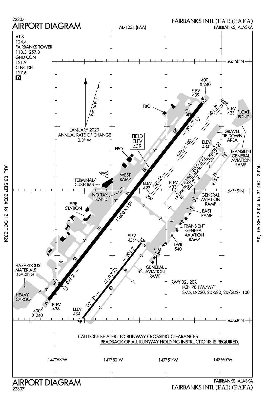
Fairbanks, AK
Fairbanks Intl
ICAO Identifier PAFA
AD 2.2 Aerodrome Geographical and Administrative Data
2.2.1 Reference Point: 64-39-56.303N / 147-06-05.149W
2.2.2 From City: 17 miles SE of FAIRBANKS, AK
2.2.3 Elevation: 547.5 ft
2.2.5 Magnetic Variation: 19E (2015)
2.2.6 Airport Contact: CHIEF AIRFIELD MANAGEMENT
343 CSG/OTM
EIELSON AFB, AK 99702 (907-377-3201)
2.2.7 Traffic: IFR/VFR
AD 2.3 Attendance Schedule
2.3.1 All Months, All Days, 1600-0800Z++ Hours
AD 2.4 Handling Services and Facilities
2.4.1 Cargo Handling Facilities: NO
2.4.2 Fuel Types:
2.4.5 Hangar Space: YES
2.4.6 Repair Facilities: None
AD 2.6 Rescue and Firefighting Services
2.6.1 Aerodrome Category: None
2.6.2 Rescue and Firefighting Services: None
AD 2.12 Runway Physical Characteristics
2.12.1 Designation: 32
2.12.2 True Bearing: 339
2.12.3 True Dimensions: 14530 ft x 150 ft
2.12.4 PCN: 61 R/C/W/T
2.12.5 Coordinates: 64-38-49.47N / 147-05-05.86W
2.12.6 Threshold Elevation: 547.5
2.12.6 Touchdown Zone Elevation: 547.5
2.12.1 Designation: 14
2.12.2 True Bearing: 159
2.12.3 True Dimensions: 14530 ft x 150 ft
2.12.4 PCN: 61 R/C/W/T
2.12.5 Coordinates: 64-41-03.13N / 147-07-04.52W
2.12.6 Threshold Elevation: 533.8
2.12.6 Touchdown Zone Elevation: 536.7
AD 2.13 Declared Distances
2.13.1 Designation: 32
2.13.2 Take-off Run Available:
2.13.3 Take-off Distance Available:
2.13.4 Accelerate-Stop Distance Available:
2.13.5 Landing Distance Available:
2.13.1 Designation: 14
2.13.2 Take-off Run Available:
2.13.3 Take-off Distance Available:
2.13.4 Accelerate-Stop Distance Available:
2.13.5 Landing Distance Available:
AD 2.14 Approach and Runway Lighting
2.14.1 Designation: 32
2.14.2 Approach Lighting System: ALSF1
2.14.4 Visual Approach Slope Indicator System: P4L
2.14.1 Designation: 14
2.14.2 Approach Lighting System: ALSF1
2.14.4 Visual Approach Slope Indicator System: P4L
AD 2.18 Air Traffic Services Communication Facilities
2.18.1 Service Designation: ATIS
2.18.3 Channel: 119.9
2.18.5 Hours of Operation: 1600-0800Z++
2.18.1 Service Designation: ATIS
2.18.3 Channel: 273.5
2.18.5 Hours of Operation: 1600-0800Z++
2.18.1 Service Designation: CD/P
2.18.3 Channel: 343.7
2.18.5 Hours of Operation: 1600-0800Z++
2.18.1 Service Designation: COMD POST (IGLOO OPS)
2.18.3 Channel: 259.5
2.18.5 Hours of Operation:
2.18.1 Service Designation: COMD POST (IGLOO OPS, HAVE QUICK)
2.18.3 Channel: 289.4
2.18.5 Hours of Operation:
2.18.1 Service Designation: GND/P
2.18.3 Channel: 121.8
2.18.5 Hours of Operation: 1600-0800Z++
2.18.1 Service Designation: GND/P
2.18.3 Channel: 275.8
2.18.5 Hours of Operation: 1600-0800Z++
2.18.1 Service Designation: LCL/P
2.18.3 Channel: 127.2
2.18.5 Hours of Operation: 1600-0800Z++
2.18.1 Service Designation: LCL/P
2.18.3 Channel: 352. 05
2.18.5 Hours of Operation: 1600-0800Z++
2.18.1 Service Designation: OPS (SOURDOUGH)
2.18.3 Channel: 139.6
2.18.5 Hours of Operation:
2.18.1 Service Designation: OPS (168 ANG OPS)
2.18.3 Channel: 238.3
2.18.5 Hours of Operation:
2.18.1 Service Designation: OPS (168 ANG OPS)
2.18.3 Channel: 293.6
2.18.5 Hours of Operation:
2.18.1 Service Designation: OPS (SOURDOUGH)
2.18.3 Channel: 359.15
2.18.5 Hours of Operation:
2.18.1 Service Designation: PTD
2.18.3 Channel: 139.3
2.18.5 Hours of Operation:
2.18.1 Service Designation: PTD
2.18.3 Channel: 372.2
2.18.5 Hours of Operation:
2.18.1 Service Designation: RANGE CTL (SUAIS RADIO)
2.18.3 Channel: 125.3
2.18.5 Hours of Operation:
2.18.1 Service Designation: SFA
2.18.3 Channel: 118.6
2.18.5 Hours of Operation:
2.18.1 Service Designation: SFA
2.18.3 Channel: 259.1
2.18.5 Hours of Operation:
2.18.1 Service Designation: SFA
2.18.3 Channel: 318.2
2.18.5 Hours of Operation:
2.18.1 Service Designation: SFA
2.18.3 Channel: 320.1
2.18.5 Hours of Operation:
2.18.1 Service Designation: SFA
2.18.3 Channel: 324.3
2.18.5 Hours of Operation:
AD 2.19 Radio Navigation and Landing Aids
2.19.1 ILS Type: Glide Slop for runway 14. Magnetic variation: 19E
2.19.2 ILS Identification: EIL
2.19.5 Coordinates: 64-40-51.57N / 147-07-06.54W
2.19.6 Site Elevation: 532.6 ft
2.19.1 ILS Type: Localizer for runway 14. Magnetic variation: 19E
2.19.2 ILS Identification: EIL
2.19.5 Coordinates: 64-38-33.06N / 147-04-51.3W
2.19.6 Site Elevation: 548.9 ft
2.19.1 ILS Type: Glide Slop for runway 32. Magnetic variation: 19E
2.19.2 ILS Identification: EAF
2.19.5 Coordinates: 64-38-58.93N / 147-05-25.28W
2.19.6 Site Elevation: 540 ft
2.19.1 ILS Type: Localizer for runway 32. Magnetic variation: 19E
2.19.2 ILS Identification: EAF
2.19.5 Coordinates: 64-41-22.09N / 147-07-21.39W
2.19.6 Site Elevation: 528.9 ft
2.19.1 Navigation Aid Type TACAN. Magnetic variation: 19E
2.19.2 Navigation Aid Identification: EIL
2.19.5 Coordinates: 64-39-13.66N / 147-05-38.32W
2.19.6 Site Elevation: 542.4 ft
General Remarks:
WATERLANE IS CONTROLLED; CTC ATCT ON FREQ 118.3 FOR APPROVAL. WATERLANE THRESHOLD BUOYS ARE 500 FROM N AND S SHORES AND MARK WATERLANE. STEP TAXI PROHIBITED OUTSIDE OF WATERLANE. EAST OF WATERLANE IS UNCONTROLLED; AIRCRAFT MAY TAXI IN THIS AREA AT PILOT DISCRETION. RECOMMEND CTC CLNC DEL AS SOON AS PRACTICAL AFTER ENG START. SFC FROZEN IN WINTER, NOT MONITORED. LIMITED TRANSIENT FLOAT PLANE PARKING AVBL CTC 907-455-4571. MIGRATORY BIRDS IN THE VICINITY OF ARPT DURING SPRING THRU FALL.
ALL RWY HOLD LINES OBSCURED OCTOBER 1 THRU APRIL 1.
WX CAMERA AVBL ON INTERNET AT HTTPS://WEATHERCAMS.FAA.GOV.
NWS WEATHER BALLOON LAUNCH SITE 2000 FEET WEST OF MIDFIELD RUNWAY 02L/20R. LAUNCHES ARE TWICE DAILY AT 1100 AND 2300 HOURS UTC.
MILITARY CONTRACT FUEL AVBL.
FOR AVBLTY OF SUMMER GRAVEL STRIP RWY 02/20 AND WINTER SKI STRIP RWY 02/20 CONSULT LOCAL NOTAMS AND CTC TWR PRIOR TO ARRIVAL /DEPARTURE.
TWY B SECURITY GATE BETWEEN RWY 02L/20R AND TWY CHARLIE KEY 121.75 5 TIMES TO ACTIVATE. IF TWY B GATE INOPERATIVE, WAIT 30 SECONDS TO RESET AND TRY AGAIN. IF UNSUCCESSFUL, NOTIFY FAI OPS, 907-451-2300
COMPASS ROSE NOT CALIBRATED.
FOR TRANSIENT HELICOPTER PARKING CALL ARPT OPS 907-451-2300.
RWY 02R/20L & RWY GRVL/SKI 02/20 NOT AVBL FOR SCHEDULED OR UNSCHEDULED ACR OPNS WITH MORE THAN 30 PSGR SEATS.
FOR FLIGHTS IN MOAS EAST OF FAIRBANKS RECOMMEND CONTACTING EIELSON RANGR CONTROL ON 125.3/126.3 OR CALL 1-800-758-8723 FOR INFORMATION ON MILITARY ACTIVITES.
COLD TEMPERATURE AIRPORT. ALTITUDE CORRECTION REQUIRED AT OR BELOW -29C.
ATCT LOCATED AT 64-48-39.438N 147-50-55.722W, ELEVATION 538 FT MSL.
BE ALERT FOR SNOW REMOVAL EQUIPMENT OPNS FM 1 OCT TO 15 MAY.
TRANSIENT PARKING EAST RAMP FOR ACFT WITH WINGSPAN LESS THAN 79 FT. NO TRANSIENT ACFT PARKING ON WEST RAMP, CTC APT OPS 907-451-2300 FOR INFO & MEDIVAC PARKING.
PPR FOR MIL ACFT UTILIZING HEAVY CARGO OR TRML APN, CTC APRT OPS
NOISE ABATEMENT PROCEDURES IN EFECT FM 2200-0800 ALL LARGE ACFT, TURBINE ENGINE, AND HEAVY ACFT UTILIZE RWY 02L FOR ARRS AND RWY 20R FOR DEPS WHEN WIND IS NOT AN OPERATIOINAL FACTOR. CTC APRT OPNS FOR ENGINE RUN-UP LOCATIONS.
N/S TAXIWAY (TWY A) IS WEST AND PARALLEL TO RWY 02L/20R. BE ALERT TO AVOID LANDING ON TAXIWAY.
SEE ADDITIONAL PAGES UNDER NOTICES FOR TRSA AND FAIRBANKS AREA INFORMATION.
RWY 02R/20L IS LIMITED FOR USE BY ACFT DESIGN GROUP B II, ACFT OR SMALLER.
Juneau, Alaska
Juneau International
ICAO Identifier PAJN
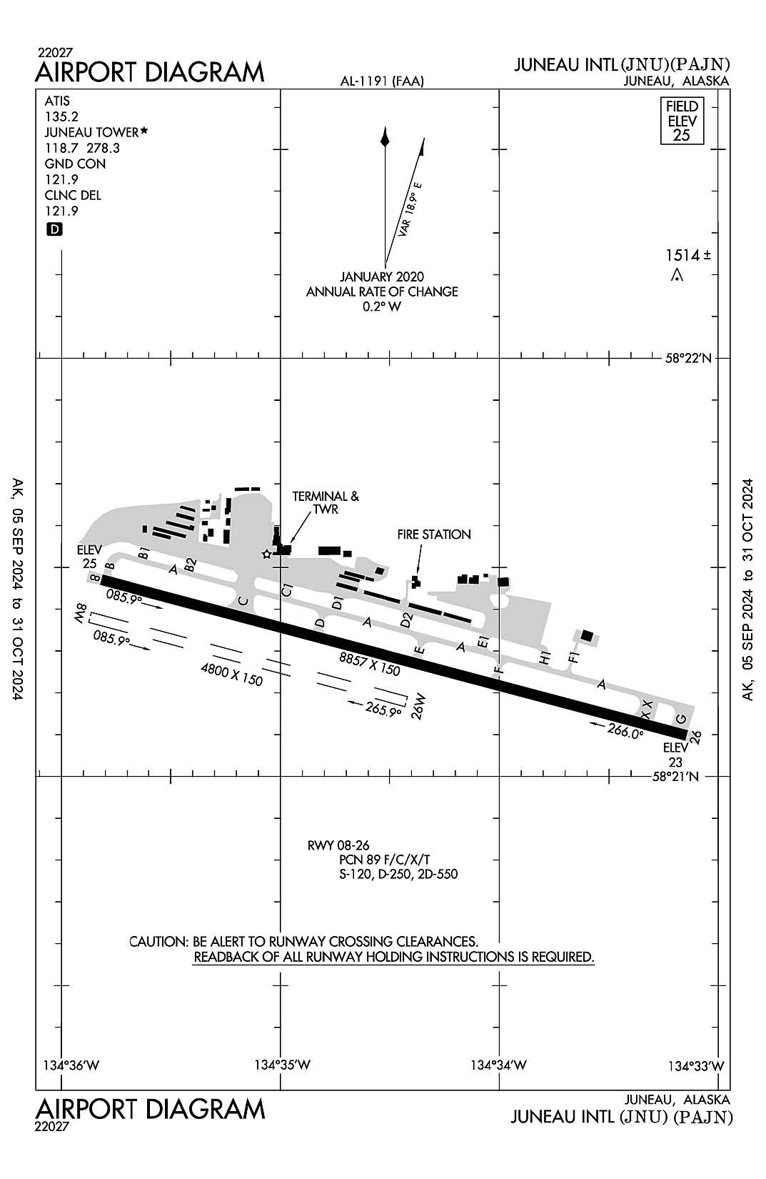
Juneau, AK
Juneau Intl
ICAO Identifier PAJN
AD 2.2 Aerodrome Geographical and Administrative Data
2.2.1 Reference Point: 58-21-16.9625N / 134-34-42.4939W
2.2.2 From City: 7 miles NW of JUNEAU, AK
2.2.3 Elevation: 25.3 ft
2.2.5 Magnetic Variation: 20E (2015)
2.2.6 Airport Contact: PATTY WAHTO
1873 SHELL SIMMONS DR, SUITE 200
JUNEAU, AK 99801 (907-789-7821)
2.2.7 Traffic: IFR/VFR
AD 2.3 Attendance Schedule
2.3.1 All Months, All Days, All Hours
AD 2.4 Handling Services and Facilities
2.4.1 Cargo Handling Facilities: YES
2.4.2 Fuel Types: 100LL A1+
2.4.5 Hangar Space: YES
2.4.6 Repair Facilities: MAJOR
AD 2.6 Rescue and Firefighting Services
2.6.1 Aerodrome Category: Class-I certified on 4/1/2005
2.6.2 Rescue and Firefighting Services: ARFF Index-C
AD 2.12 Runway Physical Characteristics
2.12.1 Designation: 08
2.12.2 True Bearing: 105
2.12.3 True Dimensions: 8857 ft x 150 ft
2.12.4 PCN: 89 F/C/X/T
2.12.5 Coordinates: 58-21-28.25N / 134-35-49.09W
2.12.6 Threshold Elevation: 25
2.12.6 Touchdown Zone Elevation: 25
2.12.1 Designation: 26
2.12.2 True Bearing: 285
2.12.3 True Dimensions: 8857 ft x 150 ft
2.12.4 PCN: 89 F/C/X/T
2.12.5 Coordinates: 58-21-05.88N / 134-33-08.63W
2.12.6 Threshold Elevation: 23.4
2.12.6 Touchdown Zone Elevation: 23.4
2.12.1 Designation: 08W
2.12.2 True Bearing:
2.12.3 True Dimensions: 4800 ft x 150 ft
2.12.4 PCN:
2.12.5 Coordinates: 58-21-22.82N / 134-35-52.23W
2.12.6 Threshold Elevation:
2.12.6 Touchdown Zone Elevation:
2.12.1 Designation: 26W
2.12.2 True Bearing:
2.12.3 True Dimensions: 4800 ft x 150 ft
2.12.4 PCN:
2.12.5 Coordinates: 58-21-10.71N / 134-34-25.26W
2.12.6 Threshold Elevation:
2.12.6 Touchdown Zone Elevation:
AD 2.13 Declared Distances
2.13.1 Designation: 08
2.13.2 Take-off Run Available: 8857
2.13.3 Take-off Distance Available: 8857
2.13.4 Accelerate-Stop Distance Available: 8457
2.13.5 Landing Distance Available: 8457
2.13.1 Designation: 26
2.13.2 Take-off Run Available: 8857
2.13.3 Take-off Distance Available: 8857
2.13.4 Accelerate-Stop Distance Available: 8457
2.13.5 Landing Distance Available: 8457
2.13.1 Designation: 08W
2.13.2 Take-off Run Available:
2.13.3 Take-off Distance Available:
2.13.4 Accelerate-Stop Distance Available:
2.13.5 Landing Distance Available:
2.13.1 Designation: 26W
2.13.2 Take-off Run Available:
2.13.3 Take-off Distance Available:
2.13.4 Accelerate-Stop Distance Available:
2.13.5 Landing Distance Available:
AD 2.14 Approach and Runway Lighting
2.14.1 Designation: 08
2.14.2 Approach Lighting System: MALSF
2.14.4 Visual Approach Slope Indicator System: V2L
2.14.1 Designation: 26
2.14.2 Approach Lighting System: MALS
2.14.4 Visual Approach Slope Indicator System: P4L
2.14.1 Designation: 08W
2.14.2 Approach Lighting System:
2.14.4 Visual Approach Slope Indicator System:
2.14.1 Designation: 26W
2.14.2 Approach Lighting System:
2.14.4 Visual Approach Slope Indicator System:
AD 2.18 Air Traffic Services Communication Facilities
2.18.1 Service Designation: ATIS
2.18.3 Channel: 135.2
2.18.5 Hours of Operation: 24
2.18.1 Service Designation: CD/P
2.18.3 Channel: 121.9
2.18.5 Hours of Operation: 1 APR - SEP 30 0600 - 2300, 1 OCT - MAR 31, 0700 - 2000.
2.18.1 Service Designation: GND/P
2.18.3 Channel: 121.9
2.18.5 Hours of Operation: 1 APR - SEP 30 0600 - 2300, 1 OCT - MAR 31, 0700 - 2000.
2.18.1 Service Designation: LCL/P
2.18.3 Channel: 118.7
2.18.5 Hours of Operation: 1 APR - SEP 30 0600 - 2300, 1 OCT - MAR 31, 0700 - 2000.
2.18.1 Service Designation: LCL/P
2.18.3 Channel: 278.3
2.18.5 Hours of Operation: 1 APR - SEP 30 0600 - 2300, 1 OCT - MAR 31, 0700 - 2000.
2.18.1 Service Designation: LCL/S (SEASONAL USE ONLY)
2.18.3 Channel: 120.7
2.18.5 Hours of Operation: 1 APR - SEP 30 0600 - 2300, 1 OCT - MAR 31, 0700 - 2000.
2.18.1 Service Designation: NG OPS
2.18.3 Channel: 64.7
2.18.5 Hours of Operation:
2.18.1 Service Designation: NG OPS
2.18.3 Channel: 124.65
2.18.5 Hours of Operation:
AD 2.19 Radio Navigation and Landing Aids
2.19.1 ILS Type: DME for runway 08. Magnetic variation: 20E
2.19.2 ILS Identification: JDL
2.19.5 Coordinates: 58-21-31.0221N / 134-38-10.216W
2.19.6 Site Elevation: 179.8 ft
2.19.1 ILS Type: Localizer for runway 08. Magnetic variation: 20E
2.19.2 ILS Identification: JDL
2.19.5 Coordinates: 58-21-32.035N / 134-38-10.3944W
2.19.6 Site Elevation: 165 ft
2.19.1 ILS Type: Outer Marker for runway 08. Magnetic variation: 20E
2.19.2 ILS Identification: JDL
2.19.5 Coordinates: 58-21-33.5717N / 134-41-58.0236W
2.19.6 Site Elevation: 57.9 ft
General Remarks:
FOR LCL CALL TO JUNEAU FSS CALL 907-789-7380.
TRANSIENT DOCK AVBL FOR PUBLIC USE FOR UP TO SIX ACFT, SW CORNER.
COLD TEMPERATURE AIRPORT. ALTITUDE CORRECTION REQUIRED AT OR BELOW 0C.
RY 08/26 SAND USED TO ENHANCE RY FRICTION MAY NOT MEET FAA SPECS.
TPA 1500 AGL FOR LARGE TURBINE ACFT; 1000 FT AGL FOR FIXED WING ACFT; 500 FT AGL FOR HELICOPTERS.
APRON TERMINAL RAMP CLSD TO ROTORCRAFT. APRON US CUSTOMS RAMP CLSD TO ACFT WITH WINGSPAN MORE THAN 79 FT INTL ACFT WITH WINGSPAN MORE THAN 79 FT AND ALL INTL ROTORCRAFT USE E-1 RAMP (NTL GUARD RAMP).
WILDLIFE & BIRDS ON & INVOF ARPT.
BATTLESHIP ISLAND RLLS GROUPING; CENTER LIGHT 582132.88N 1344012.22W. IJDL-LOCALIZER RLLS GROUPING; CENTER LIGHT 582132.02N 1343810.39W.
LENA POINT, PEDERSON HILL AND SISTERS ISLAND WX CAMERAS AVBL ON INTERNET AT HTTPS://WEATHERCAMS.FAA.GOV
PARAGLIDING ACTIVITY 3 MILES N OF ARPT INVOF THUNDER MOUNTAIN & OVER GASTINEAU CHANNEL NEARS DOWNTOWN APR 15-OCT 1 6000 FT & BLO.
INCREASED HELICOPTER/LIGH ACFT ACTIVITY APR 15-OCT 1 ENTIRE LENGTH ON GASTINEAU CHANNEL & WITHIN 5 MILES OF ARPT.
NATIONAL GUARD 24 HR PPR DUE TO LIMITED PARKING C907-789-3366. 0730-1600 WEEKDAYS CONTACT GUARD OPS 10 MIN PRIOR TO LANDING ON 124.65.
SEE SPECIAL NOTICES AND GENERAL NOTICES FOR ADDITIONAL INFORMATION ON OPNS IN JUNEAU AREA.
King Salmon, Alaska
King Salmon
ICAO Identifier PAKN
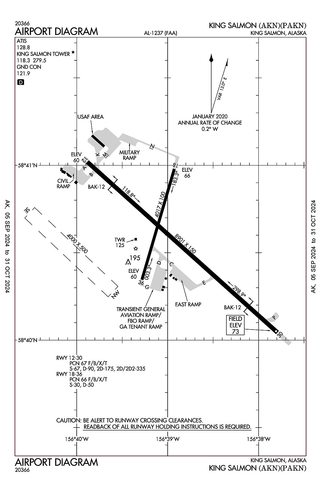
King Salmon, AK
King Salmon
ICAO Identifier PAKN
AD 2.2 Aerodrome Geographical and Administrative Data
2.2.1 Reference Point: 58-40-35.3765N / 156-38-55.2876W
2.2.2 From City: 0 miles SE of KING SALMON, AK
2.2.3 Elevation: 73.4 ft
2.2.5 Magnetic Variation: 11E (2025)
2.2.6 Airport Contact: FLOYD WILSON
PO BOX 65
KING SALMON, AK 99613 (907-246-3325)
2.2.7 Traffic: IFR/VFR
AD 2.3 Attendance Schedule
2.3.1 All Months, All Days, 0700-1700 Hours
AD 2.4 Handling Services and Facilities
2.4.1 Cargo Handling Facilities: YES
2.4.2 Fuel Types: 100LL A
2.4.5 Hangar Space:
2.4.6 Repair Facilities: MAJOR
AD 2.6 Rescue and Firefighting Services
2.6.1 Aerodrome Category: Class-I certified on 3/21/2005
2.6.2 Rescue and Firefighting Services: ARFF Index-B
AD 2.12 Runway Physical Characteristics
2.12.1 Designation: 30
2.12.2 True Bearing: 312
2.12.3 True Dimensions: 8901 ft x 150 ft
2.12.4 PCN: 67 F/B/X/T
2.12.5 Coordinates: 58-40-03.68N / 156-37-47.63W
2.12.6 Threshold Elevation: 73.4
2.12.6 Touchdown Zone Elevation: 73.4
2.12.1 Designation: 12
2.12.2 True Bearing: 132
2.12.3 True Dimensions: 8901 ft x 150 ft
2.12.4 PCN: 67 F/B/X/T
2.12.5 Coordinates: 58-41-02.184N / 156-39-53.0154W
2.12.6 Threshold Elevation: 59.9
2.12.6 Touchdown Zone Elevation: 61.8
2.12.1 Designation: 18
2.12.2 True Bearing: 196
2.12.3 True Dimensions: 4017 ft x 100 ft
2.12.4 PCN: 66 F/B/X/T
2.12.5 Coordinates: 58-40-59.7835N / 156-38-55.6139W
2.12.6 Threshold Elevation: 66.1
2.12.6 Touchdown Zone Elevation: 66.1
2.12.1 Designation: 36
2.12.2 True Bearing: 16
2.12.3 True Dimensions: 4017 ft x 100 ft
2.12.4 PCN: 66 F/B/X/T
2.12.5 Coordinates: 58-40-21.7997N / 156-39-16.9583W
2.12.6 Threshold Elevation: 59.9
2.12.6 Touchdown Zone Elevation: 65.2
2.12.1 Designation: NW
2.12.2 True Bearing:
2.12.3 True Dimensions: 4000 ft x 500 ft
2.12.4 PCN:
2.12.5 Coordinates:
2.12.6 Threshold Elevation:
2.12.6 Touchdown Zone Elevation:
2.12.1 Designation: SE
2.12.2 True Bearing:
2.12.3 True Dimensions: 4000 ft x 500 ft
2.12.4 PCN:
2.12.5 Coordinates:
2.12.6 Threshold Elevation:
2.12.6 Touchdown Zone Elevation:
AD 2.13 Declared Distances
2.13.1 Designation: 30
2.13.2 Take-off Run Available: 8901
2.13.3 Take-off Distance Available: 8901
2.13.4 Accelerate-Stop Distance Available: 8501
2.13.5 Landing Distance Available: 8501
2.13.1 Designation: 12
2.13.2 Take-off Run Available: 8901
2.13.3 Take-off Distance Available: 8901
2.13.4 Accelerate-Stop Distance Available: 8501
2.13.5 Landing Distance Available: 8501
2.13.1 Designation: 18
2.13.2 Take-off Run Available:
2.13.3 Take-off Distance Available:
2.13.4 Accelerate-Stop Distance Available:
2.13.5 Landing Distance Available:
2.13.1 Designation: 36
2.13.2 Take-off Run Available:
2.13.3 Take-off Distance Available:
2.13.4 Accelerate-Stop Distance Available:
2.13.5 Landing Distance Available:
2.13.1 Designation: NW
2.13.2 Take-off Run Available:
2.13.3 Take-off Distance Available:
2.13.4 Accelerate-Stop Distance Available:
2.13.5 Landing Distance Available:
2.13.1 Designation: SE
2.13.2 Take-off Run Available:
2.13.3 Take-off Distance Available:
2.13.4 Accelerate-Stop Distance Available:
2.13.5 Landing Distance Available:
AD 2.14 Approach and Runway Lighting
2.14.1 Designation: 30
2.14.2 Approach Lighting System:
2.14.4 Visual Approach Slope Indicator System: P4L
2.14.1 Designation: 12
2.14.2 Approach Lighting System: SSALR
2.14.4 Visual Approach Slope Indicator System: P4L
2.14.1 Designation: 18
2.14.2 Approach Lighting System:
2.14.4 Visual Approach Slope Indicator System:
2.14.1 Designation: 36
2.14.2 Approach Lighting System:
2.14.4 Visual Approach Slope Indicator System:
2.14.1 Designation: NW
2.14.2 Approach Lighting System:
2.14.4 Visual Approach Slope Indicator System:
2.14.1 Designation: SE
2.14.2 Approach Lighting System:
2.14.4 Visual Approach Slope Indicator System:
AD 2.18 Air Traffic Services Communication Facilities
2.18.1 Service Designation: ATIS
2.18.3 Channel: 128.8
2.18.5 Hours of Operation: 24
2.18.1 Service Designation: GND/P
2.18.3 Channel: 121.9
2.18.5 Hours of Operation: 0800-2000 1 AUG-14 JUN. 0800-2200 15 JUN- 31 JUL.
2.18.1 Service Designation: LCL/P
2.18.3 Channel: 118.3
2.18.5 Hours of Operation: 0800-2000 1 AUG-14 JUN. 0800-2200 15 JUN- 31 JUL.
2.18.1 Service Designation: LCL/P
2.18.3 Channel: 279.5
2.18.5 Hours of Operation: 0800-2000 1 AUG-14 JUN. 0800-2200 15 JUN- 31 JUL.
2.18.1 Service Designation: PTD
2.18.3 Channel: 372.2
2.18.5 Hours of Operation:
AD 2.19 Radio Navigation and Landing Aids
2.19.1 ILS Type: DME for runway 12. Magnetic variation: 11E
2.19.2 ILS Identification: AKN
2.19.5 Coordinates: 58-39-59.6N / 156-37-31.7W
2.19.6 Site Elevation: 78 ft
2.19.1 ILS Type: Glide Slop for runway 12. Magnetic variation: 11E
2.19.2 ILS Identification: AKN
2.19.5 Coordinates: 58-40-57.3435N / 156-39-29.887W
2.19.6 Site Elevation: 63.5 ft
2.19.1 ILS Type: Localizer for runway 12. Magnetic variation: 11E
2.19.2 ILS Identification: AKN
2.19.5 Coordinates: 58-39-56.5549N / 156-37-32.3734W
2.19.6 Site Elevation: 77.7 ft
2.19.1 Navigation Aid Type VORTAC. Magnetic variation: 16E
2.19.2 Navigation Aid Identification: AKN
2.19.5 Coordinates: 58-43-28.9653N / 156-45-08.4483W
2.19.6 Site Elevation: 94.6 ft
General Remarks:
USAF FAC CIV OPRD WITH LTD SUPPORT; CALL 24 HR PRIOR TO ARR FOR OPS HR; MIL CONFIRM FUEL RQMNTS 24-48 HR PRIOR.
FIGHTER ARR EXP RDCD SEPN; SIMILAR APCH CHARCS & DALGT 3000 FT; DISSIMILAR APCH CHARCS & NGT 6000 FT; AHD/BHND FRMN LNDG 6000 FT.
FLOCKS OF LRG BIRDS INVOF DURG SEASON.
TWY P CLSD. APRON SPOTS 4 - 7 N OF MIL HANGAR CLSD EXC PROP ACFT.
RCR DURG 11TH AF FIGHTER FLYING WINDOW; COORD RCR WITH KING SALMON OPS 907-439-3001/907-439-6000. OPS RSTRD TO LOW APCH/FSL ONLY.
600 FT SAFETY AREA AER 12.
BUSINESS JET PRKG GTR THAN 1 HR 48 HR PPR.
FLIGHT ORIG OUTSIDE AK REFER TO USAF FCG; CSTMS NOT AVBL.
CIV TSNT PRKG ON SE RAMP ONLY; OTR PRKG GTR THAN 48 HR RQRS PERMIT.
LOCKED WHEEL TURN NA ALL SFCS.
MIL FIGHTER/EMERG DVRSN CTC WARRIOR/ELMENDORF SOF 395.15; NON FIGHTER/EMERG CTC KING SALMON OPS. 24 HR POINT MNTS CTAF DURG OPS HR.
GA APRON PAVEMENT CRUMBLING; PSBL FOD HAZ. JET ACFT BE ALERT DURG RUN UP TO AVOID JET WASH DMG.
SNOW/ICE REMOVAL & ARPT HAZ COND RPRTD DURG ATND HR.
OFF PAVEMENT OPS BY ACFT & HEL NA AT ACR APRON. LNDG, TKOF OR PRKG FM DIRT OR GRASS NA.
TSA REG ARPT; SEE 49 CFR 1542. ALL GATES & DOORS RMN SECURE ALL TIMES. TSNT OR UNFAMILIAR PILOTS - AMGR FOR INFO.
PVT JET PRKG SE SECTION OF E RAMP - AMGR FOR INFO.
WX CAMERA AVBL ON INTERNET AT HTTPS://WEATHERCAMS.FAA.GOV
ARFF AVBL FOR PART 121 ACR INVOLVED IN ETOPS WITH 30 MIN NOTICE.
NWS BLN LAUNCH FAC ON ARPT; SEE INSIDE BACK COVER FOR OPS DETAIL.