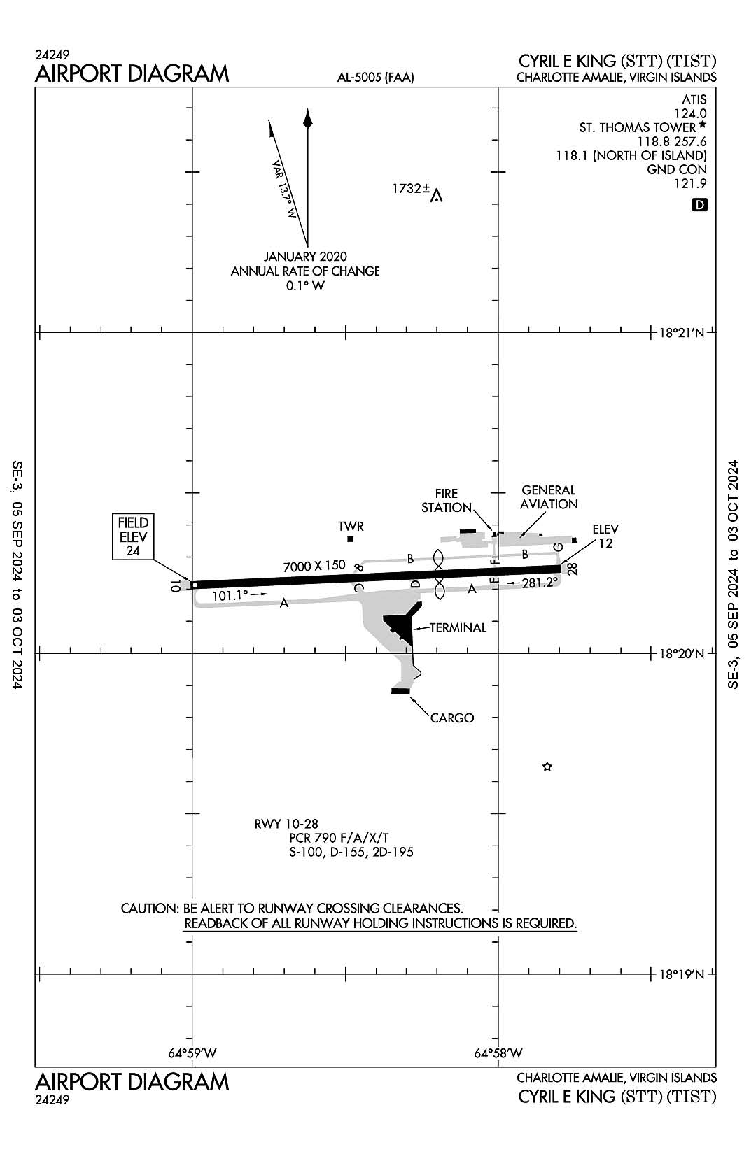
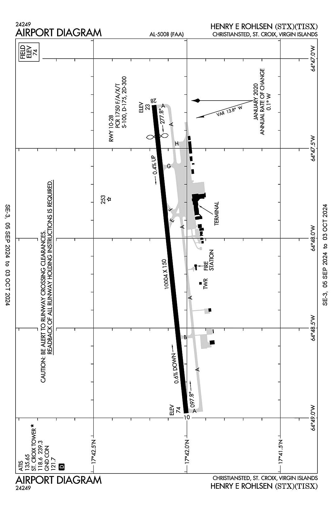
Virgin Islands
Charlotte Amalie St. Thomas, Virgin Islands
Cyril E King
ICAO Identifier TIST

Charlotte Amalie, VI
Cyril E King
ICAO Identifier TIST
AD 2.2 Aerodrome Geographical and Administrative Data
2.2.1 Reference Point: 18-20-14.3N / 64-58-24W
2.2.2 From City: 2 miles W of CHARLOTTE AMALIE, VI
2.2.3 Elevation: 23.6 ft
2.2.5 Magnetic Variation: 13W (2000)
2.2.6 Airport Contact: JEROME SHERIDAN
CYRIL E. KING AIRPORT
ST THOMAS, VI 802 ((340) 714-6667)
2.2.7 Traffic: IFR/VFR
AD 2.3 Attendance Schedule
2.3.1 All Months, All Days, 0700-2300 Hours
AD 2.4 Handling Services and Facilities
2.4.1 Cargo Handling Facilities: YES
2.4.2 Fuel Types: 100LL A
2.4.5 Hangar Space: YES
2.4.6 Repair Facilities: MINOR
AD 2.6 Rescue and Firefighting Services
2.6.1 Aerodrome Category: Class-I certified on 5/1/1973
2.6.2 Rescue and Firefighting Services: ARFF Index-C
AD 2.12 Runway Physical Characteristics
2.12.1 Designation: 28
2.12.2 True Bearing: 267
2.12.3 True Dimensions: 7000 ft x 150 ft
2.12.4 PCN:
2.12.5 Coordinates: 18-20-15.8124N / 64-57-47.7382W
2.12.6 Threshold Elevation: 11.7
2.12.6 Touchdown Zone Elevation: 16.5
2.12.1 Designation: 10
2.12.2 True Bearing: 87
2.12.3 True Dimensions: 7000 ft x 150 ft
2.12.4 PCN:
2.12.5 Coordinates: 18-20-12.7247N / 64-59-00.3371W
2.12.6 Threshold Elevation: 23.5
2.12.6 Touchdown Zone Elevation: 23.6
AD 2.13 Declared Distances
2.13.1 Designation: 28
2.13.2 Take-off Run Available: 7000
2.13.3 Take-off Distance Available: 7000
2.13.4 Accelerate-Stop Distance Available: 6170
2.13.5 Landing Distance Available: 3870
2.13.1 Designation: 10
2.13.2 Take-off Run Available: 7000
2.13.3 Take-off Distance Available: 7000
2.13.4 Accelerate-Stop Distance Available: 6892
2.13.5 Landing Distance Available: 6892
AD 2.14 Approach and Runway Lighting
2.14.1 Designation: 28
2.14.2 Approach Lighting System:
2.14.4 Visual Approach Slope Indicator System:
2.14.1 Designation: 10
2.14.2 Approach Lighting System:
2.14.4 Visual Approach Slope Indicator System: P4L
AD 2.18 Air Traffic Services Communication Facilities
2.18.1 Service Designation: ATIS
2.18.3 Channel: 124
2.18.5 Hours of Operation: 24
2.18.1 Service Designation: EMERG
2.18.3 Channel: 121.5
2.18.5 Hours of Operation:
2.18.1 Service Designation: EMERG
2.18.3 Channel: 243
2.18.5 Hours of Operation:
2.18.1 Service Designation: GND/P
2.18.3 Channel: 121.9
2.18.5 Hours of Operation: 0700-2230, ATCT CLOSES 1 HR EARLIER DRG DALGT SAVINGS TIME.
2.18.1 Service Designation: LCL/P (NORTH OF ISLAND)
2.18.3 Channel: 118.1
2.18.5 Hours of Operation: 0700-2230, ATCT CLOSES 1 HR EARLIER DRG DALGT SAVINGS TIME.
2.18.1 Service Designation: LCL/P
2.18.3 Channel: 118.8
2.18.5 Hours of Operation: 0700-2230, ATCT CLOSES 1 HR EARLIER DRG DALGT SAVINGS TIME.
2.18.1 Service Designation: LCL/P
2.18.3 Channel: 257.6
2.18.5 Hours of Operation: 0700-2230, ATCT CLOSES 1 HR EARLIER DRG DALGT SAVINGS TIME.
AD 2.19 Radio Navigation and Landing Aids
2.19.1 ILS Type: DME for runway 10. Magnetic variation: 13W
2.19.2 ILS Identification: TMN
2.19.5 Coordinates: 18-20-18.78N / 64-57-39.88W
2.19.6 Site Elevation: 22.6 ft
2.19.1 ILS Type: Glide Slop for runway 10. Magnetic variation: 13W
2.19.2 ILS Identification: TMN
2.19.5 Coordinates: 18-20-10.62N / 64-58-48.29W
2.19.6 Site Elevation: 15.1 ft
2.19.1 ILS Type: Localizer for runway 10. Magnetic variation: 13W
2.19.2 ILS Identification: TMN
2.19.5 Coordinates: 18-20-16.26N / 64-57-37.22W
2.19.6 Site Elevation: 17 ft
2.19.1 Navigation Aid Type VOR/DME. Magnetic variation: 10W
2.19.2 Navigation Aid Identification: STT
2.19.5 Coordinates: 18-21-20.9431N / 65-01-28.3968W
2.19.6 Site Elevation: 679.2 ft
General Remarks:
LGTS ON HILL 4 NM SE OF ARPT MAY BE MISTAKEN FOR RY 10/28 WHEN MAKING A VISUAL APCH FROM THE SOUTH.
ACFT THAT BACK TAXI FOR DEP ON RY 28 SHALL MAKE THEIR 180 DEG TURN CCLKWS.
NOISE SENSITIVE AREA: AVOID OVERFLIGHTS OF WATER ISLAND LOCATED 2 MI SE OF ARPT.
RY 10 DEPS MAINTAIN RY HDG UNTIL REACHING DEP END OF RY BFR TURNING ON COURSE OR ASSIGNED HDG UNLESS OTRW AUZD BY ATCT.
WHEN TWR CLSD CTC SAN JUAN CERAP AT 787-253-8664/8665
PILOTS CTC GND CTL PRIOR TO PUSHBACK.
ARFF UNAVBL 2300-0600.
PILOTS MAY ENCTR FALSE ILLUSORY INDICATIONS DURG NGT VISUAL APCHS TO RY 10 WHEN USING VISUAL CUES FOR VERTICAL GUIDANCE; RCMD USE OF THE ILS GS & FQT CROSS REF WITH THE ACFT ALTM TO MAINT THE PROPER APCH PROFILE.
OBSTRUCTION SAILBOAT MAST 100FT WEST OF APPROACH END OF RWY 10 50FT AGL
Christiansted St. Croix
Henry E Rohlsen
ICAO Identifier TISX

Christiansted, VI
Henry E Rohlsen
ICAO Identifier TISX
AD 2.2 Aerodrome Geographical and Administrative Data
2.2.1 Reference Point: 17-42-05.416N / 64-48-06.9945W
2.2.2 From City: 6 miles SW of CHRISTIANSTED, VI
2.2.3 Elevation: 74.1 ft
2.2.5 Magnetic Variation: 13W (2000)
2.2.6 Airport Contact: JEROME SHERIDAN
P.O. BOX 1134
ST CROIX, VI 821 (340-714-6662)
2.2.7 Traffic: IFR/VFR
AD 2.3 Attendance Schedule
2.3.1 All Months, All Days, 0500-2300 Hours
AD 2.4 Handling Services and Facilities
2.4.1 Cargo Handling Facilities: NO
2.4.2 Fuel Types: 100LL A1+
2.4.5 Hangar Space: YES
2.4.6 Repair Facilities: NONE
AD 2.6 Rescue and Firefighting Services
2.6.1 Aerodrome Category: Class-I certified on 5/1/1973
2.6.2 Rescue and Firefighting Services: ARFF Index-C
AD 2.12 Runway Physical Characteristics
2.12.1 Designation: 28
2.12.2 True Bearing: 264
2.12.3 True Dimensions: 10004 ft x 150 ft
2.12.4 PCN:
2.12.5 Coordinates: 17-42-10.62N / 64-47-15.544W
2.12.6 Threshold Elevation: 22.5
2.12.6 Touchdown Zone Elevation: 40
2.12.1 Designation: 10
2.12.2 True Bearing: 84
2.12.3 True Dimensions: 10004 ft x 150 ft
2.12.4 PCN:
2.12.5 Coordinates: 17-42-00.212N / 64-48-58.445W
2.12.6 Threshold Elevation: 73.7
2.12.6 Touchdown Zone Elevation: 74.1
AD 2.13 Declared Distances
2.13.1 Designation: 28
2.13.2 Take-off Run Available: 10004
2.13.3 Take-off Distance Available: 10004
2.13.4 Accelerate-Stop Distance Available: 10004
2.13.5 Landing Distance Available: 8998
2.13.1 Designation: 10
2.13.2 Take-off Run Available: 10004
2.13.3 Take-off Distance Available: 10004
2.13.4 Accelerate-Stop Distance Available: 9003
2.13.5 Landing Distance Available: 9003
AD 2.14 Approach and Runway Lighting
2.14.1 Designation: 28
2.14.2 Approach Lighting System:
2.14.4 Visual Approach Slope Indicator System: P4L
2.14.1 Designation: 10
2.14.2 Approach Lighting System: MALSR
2.14.4 Visual Approach Slope Indicator System: P4L
AD 2.18 Air Traffic Services Communication Facilities
2.18.1 Service Designation: ATIS
2.18.3 Channel: 135.65
2.18.5 Hours of Operation: 24
2.18.1 Service Designation: EMERG
2.18.3 Channel: 121.5
2.18.5 Hours of Operation:
2.18.1 Service Designation: EMERG
2.18.3 Channel: 243
2.18.5 Hours of Operation:
2.18.1 Service Designation: GND/P
2.18.3 Channel: 121.7
2.18.5 Hours of Operation: 0700-2200
2.18.1 Service Designation: LCL/P
2.18.3 Channel: 118.6
2.18.5 Hours of Operation: 0700-2200
2.18.1 Service Designation: LCL/P
2.18.3 Channel: 239.3
2.18.5 Hours of Operation: 0700-2200
AD 2.19 Radio Navigation and Landing Aids
2.19.1 ILS Type: Glide Slop for runway 10. Magnetic variation: 13W
2.19.2 ILS Identification: STX
2.19.5 Coordinates: 17-41-58.77N / 64-48-45.5W
2.19.6 Site Elevation: 63.5 ft
2.19.1 ILS Type: Localizer for runway 10. Magnetic variation: 13W
2.19.2 ILS Identification: STX
2.19.5 Coordinates: 17-42-11.36N / 64-47-08.28W
2.19.6 Site Elevation: 26.4 ft
2.19.1 ILS Type: Outer Marker for runway 10. Magnetic variation: 13W
2.19.2 ILS Identification: STX
2.19.5 Coordinates: 17-41-30.92N / 64-53-04.74W
2.19.6 Site Elevation: 40 ft
General Remarks:
APCH TO RY 28 SMTMS OBSCD BY SMOKE FM LANDFILL LCTD E OF ARPT.
BIRDS & WILDLIFE ON & INVOF ARPT.
AP SFC COND UNMON DLY 2300 - 0600 AST.
WHEN TWR CLSD CTC SAN JUAN CERAP AT 787-253-8664/8665