Missouri
Kansas City, Missouri
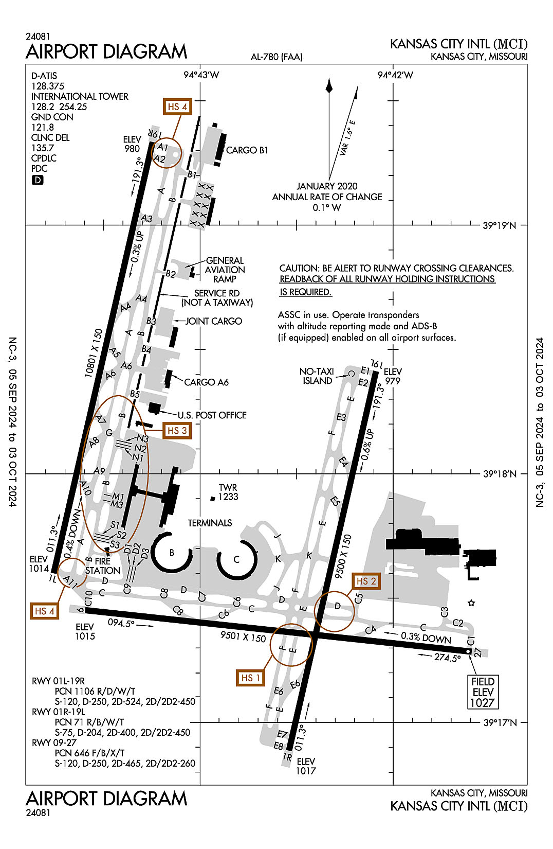
Kansas City International
ICAO Identifier KMCI
Kansas City, MO
Kansas City Intl
ICAO Identifier KMCI
AD 2.2 Aerodrome Geographical and Administrative Data
2.2.1 Reference Point: 39-17-51.4N / 94-42-50W
2.2.2 From City: 15 miles NW of KANSAS CITY, MO
2.2.3 Elevation: 1026.9 ft
2.2.5 Magnetic Variation: 2E (2015)
2.2.6 Airport Contact: MR. LUKE MAWHIRTER
P.O. BOX 20047
KANSAS CITY, MO 64195 (816-243-5248)
2.2.7 Traffic: IFR/VFR
AD 2.3 Attendance Schedule
2.3.1 All Months, All Days, All Hours
AD 2.4 Handling Services and Facilities
2.4.1 Cargo Handling Facilities: YES
2.4.2 Fuel Types: 100LL A
2.4.5 Hangar Space:
2.4.6 Repair Facilities: NONE
AD 2.6 Rescue and Firefighting Services
2.6.1 Aerodrome Category: Class-I certified on 5/1/1973
2.6.2 Rescue and Firefighting Services: ARFF Index-C
AD 2.12 Runway Physical Characteristics
2.12.1 Designation: 01L
2.12.2 True Bearing: 13
2.12.3 True Dimensions: 10801 ft x 150 ft
2.12.4 PCN:
2.12.5 Coordinates: 39-17-36.0029N / 94-43-45.5433W
2.12.6 Threshold Elevation: 1014.4
2.12.6 Touchdown Zone Elevation: 1014.4
2.12.1 Designation: 19R
2.12.2 True Bearing: 193
2.12.3 True Dimensions: 10801 ft x 150 ft
2.12.4 PCN:
2.12.5 Coordinates: 39-19-20.0396N / 94-43-14.7835W
2.12.6 Threshold Elevation: 979.6
2.12.6 Touchdown Zone Elevation: 990.5
2.12.1 Designation: 01R
2.12.2 True Bearing: 13
2.12.3 True Dimensions: 9500 ft x 150 ft
2.12.4 PCN: 71 R/B/W/T
2.12.5 Coordinates: 39-16-53.2341N / 94-42-32.3935W
2.12.6 Threshold Elevation: 1017.2
2.12.6 Touchdown Zone Elevation: 1017.4
2.12.1 Designation: 19L
2.12.2 True Bearing: 193
2.12.3 True Dimensions: 9500 ft x 150 ft
2.12.4 PCN: 71 R/B/W/T
2.12.5 Coordinates: 39-18-24.7369N / 94-42-05.3226W
2.12.6 Threshold Elevation: 978.5
2.12.6 Touchdown Zone Elevation: 995.2
2.12.1 Designation: 27
2.12.2 True Bearing: 276
2.12.3 True Dimensions: 9501 ft x 150 ft
2.12.4 PCN:
2.12.5 Coordinates: 39-17-17.0716N / 94-41-35.5978W
2.12.6 Threshold Elevation: 1026.9
2.12.6 Touchdown Zone Elevation: 1026.9
2.12.1 Designation: 09
2.12.2 True Bearing: 96
2.12.3 True Dimensions: 9501 ft x 150 ft
2.12.4 PCN:
2.12.5 Coordinates: 39-17-27.099N / 94-43-35.7371W
2.12.6 Threshold Elevation: 1015.3
2.12.6 Touchdown Zone Elevation: 1015.7
AD 2.13 Declared Distances
2.13.1 Designation: 01L
2.13.2 Take-off Run Available: 10801
2.13.3 Take-off Distance Available: 10801
2.13.4 Accelerate-Stop Distance Available: 10801
2.13.5 Landing Distance Available: 10801
2.13.1 Designation: 19R
2.13.2 Take-off Run Available: 10801
2.13.3 Take-off Distance Available: 10801
2.13.4 Accelerate-Stop Distance Available: 10801
2.13.5 Landing Distance Available: 10801
2.13.1 Designation: 01R
2.13.2 Take-off Run Available: 9500
2.13.3 Take-off Distance Available: 9500
2.13.4 Accelerate-Stop Distance Available: 9500
2.13.5 Landing Distance Available: 9500
2.13.1 Designation: 19L
2.13.2 Take-off Run Available: 9500
2.13.3 Take-off Distance Available: 9500
2.13.4 Accelerate-Stop Distance Available: 9500
2.13.5 Landing Distance Available: 9500
2.13.1 Designation: 27
2.13.2 Take-off Run Available: 9501
2.13.3 Take-off Distance Available: 9501
2.13.4 Accelerate-Stop Distance Available: 9501
2.13.5 Landing Distance Available: 9501
2.13.1 Designation: 09
2.13.2 Take-off Run Available: 9501
2.13.3 Take-off Distance Available: 9501
2.13.4 Accelerate-Stop Distance Available: 9501
2.13.5 Landing Distance Available: 9501
AD 2.14 Approach and Runway Lighting
2.14.1 Designation: 01L
2.14.2 Approach Lighting System: MALSR
2.14.4 Visual Approach Slope Indicator System: P4L
2.14.1 Designation: 19R
2.14.2 Approach Lighting System: ALSF2
2.14.4 Visual Approach Slope Indicator System: P4R
2.14.1 Designation: 01R
2.14.2 Approach Lighting System: ALSF2
2.14.4 Visual Approach Slope Indicator System: P4R
2.14.1 Designation: 19L
2.14.2 Approach Lighting System: MALSR
2.14.4 Visual Approach Slope Indicator System:
2.14.1 Designation: 27
2.14.2 Approach Lighting System: MALSR
2.14.4 Visual Approach Slope Indicator System: P4L
2.14.1 Designation: 09
2.14.2 Approach Lighting System: MALSR
2.14.4 Visual Approach Slope Indicator System:
AD 2.18 Air Traffic Services Communication Facilities
2.18.1 Service Designation: APCH/P
2.18.3 Channel: 120.95
2.18.5 Hours of Operation: 24
2.18.1 Service Designation: APCH/P
2.18.3 Channel: 318.1
2.18.5 Hours of Operation: 24
2.18.1 Service Designation: BRAYMER STAR
2.18.3 Channel: 120.95
2.18.5 Hours of Operation: 24
2.18.1 Service Designation: BRAYMER STAR
2.18.3 Channel: 318.1
2.18.5 Hours of Operation: 24
2.18.1 Service Designation: CD/P
2.18.3 Channel: 135.7
2.18.5 Hours of Operation: 24
2.18.1 Service Designation: CHIEF DP
2.18.3 Channel: 124.7
2.18.5 Hours of Operation: 24
2.18.1 Service Designation: CHIEF DP
2.18.3 Channel: 284.7
2.18.5 Hours of Operation: 24
2.18.1 Service Designation: CLASS B (EAST OF RWY 01/19)
2.18.3 Channel: 118.4
2.18.5 Hours of Operation: 24
2.18.1 Service Designation: CLASS B (S OF A LINE FROM LWC ARPT TO 3GV ARPT)
2.18.3 Channel: 118.9
2.18.5 Hours of Operation: 24
2.18.1 Service Designation: CLASS B (WEST OF RWY 01/19)
2.18.3 Channel: 124.7
2.18.5 Hours of Operation: 24
2.18.1 Service Designation: CLASS B (EAST OF RWY 01-19)
2.18.3 Channel: 294.7
2.18.5 Hours of Operation: 24
2.18.1 Service Designation: CLASS B (S OF A LINE FROM LWC ARPT TO 3GV ARPT)
2.18.3 Channel: 294.7
2.18.5 Hours of Operation: 24
2.18.1 Service Designation: CLASS B (WEST OF RWY 01/19)
2.18.3 Channel: 318.1
2.18.5 Hours of Operation: 24
2.18.1 Service Designation: D-ATIS
2.18.3 Channel: 128.375
2.18.5 Hours of Operation: 24
2.18.1 Service Designation: DEP/P (010-190)
2.18.3 Channel: 123.95
2.18.5 Hours of Operation: 24
2.18.1 Service Designation: DEP/P (191-009)
2.18.3 Channel: 124.7
2.18.5 Hours of Operation: 24
2.18.1 Service Designation: DEP/P (191-009)
2.18.3 Channel: 284.7
2.18.5 Hours of Operation: 24
2.18.1 Service Designation: DEP/P (010-190)
2.18.3 Channel: 318.1
2.18.5 Hours of Operation: 24
2.18.1 Service Designation: EMERG
2.18.3 Channel: 121.5
2.18.5 Hours of Operation:
2.18.1 Service Designation: EMERG
2.18.3 Channel: 243
2.18.5 Hours of Operation:
2.18.1 Service Designation: GND/P
2.18.3 Channel: 121.8
2.18.5 Hours of Operation: 24
2.18.1 Service Designation: GND/S
2.18.3 Channel: 121.65
2.18.5 Hours of Operation: 24
2.18.1 Service Designation: JHAWK STAR
2.18.3 Channel: 120.95
2.18.5 Hours of Operation: 24
2.18.1 Service Designation: JHAWK STAR
2.18.3 Channel: 318.1
2.18.5 Hours of Operation: 24
2.18.1 Service Designation: LAKES DP
2.18.3 Channel: 123.95
2.18.5 Hours of Operation: 24
2.18.1 Service Designation: LAKES DP
2.18.3 Channel: 318.1
2.18.5 Hours of Operation: 24
2.18.1 Service Designation: LCL/P
2.18.3 Channel: 128.2
2.18.5 Hours of Operation: 24
2.18.1 Service Designation: LCL/P
2.18.3 Channel: 254.25
2.18.5 Hours of Operation: 24
2.18.1 Service Designation: LCL/S
2.18.3 Channel: 125.75
2.18.5 Hours of Operation: 24
2.18.1 Service Designation: RACER DP (BUTLER/SPRINGFIELD TRANSITION)
2.18.3 Channel: 123.95
2.18.5 Hours of Operation: 24
2.18.1 Service Designation: RACER DP (DOSOA TRANSITION)
2.18.3 Channel: 124.7
2.18.5 Hours of Operation: 24
2.18.1 Service Designation: RACER DP (DOSOA TRANSITION)
2.18.3 Channel: 284.7
2.18.5 Hours of Operation: 24
2.18.1 Service Designation: RACER DP (BUTLER/SPRINGFIELD TRANSITION)
2.18.3 Channel: 318.1
2.18.5 Hours of Operation: 24
2.18.1 Service Designation: ROYAL DP (ARENZ/BODYN TRANSITION)
2.18.3 Channel: 123.95
2.18.5 Hours of Operation: 24
2.18.1 Service Designation: ROYAL DP (TONCE TRANSITION)
2.18.3 Channel: 124.7
2.18.5 Hours of Operation: 24
2.18.1 Service Designation: ROYAL DP (TONCE TRANSITION)
2.18.3 Channel: 284.7
2.18.5 Hours of Operation: 24
2.18.1 Service Designation: ROYAL DP (ARENZ/BODYN TRANSITION)
2.18.3 Channel: 318.1
2.18.5 Hours of Operation: 24
2.18.1 Service Designation: TIFTO DP
2.18.3 Channel: 124.7
2.18.5 Hours of Operation: 24
2.18.1 Service Designation: TIFTO DP
2.18.3 Channel: 284.7
2.18.5 Hours of Operation: 24
2.18.1 Service Designation: TYGER STAR
2.18.3 Channel: 120.95
2.18.5 Hours of Operation: 24
2.18.1 Service Designation: TYGER STAR
2.18.3 Channel: 318.1
2.18.5 Hours of Operation: 24
2.18.1 Service Designation: WILDCAT DP
2.18.3 Channel: 124.7
2.18.5 Hours of Operation: 24
2.18.1 Service Designation: WILDCAT DP
2.18.3 Channel: 284.7
2.18.5 Hours of Operation: 24
AD 2.19 Radio Navigation and Landing Aids
2.19.1 ILS Type: DME for runway 01L. Magnetic variation: 2E
2.19.2 ILS Identification: DOT
2.19.5 Coordinates: 39-19-30.0746N / 94-43-08.2388W
2.19.6 Site Elevation: 988.8 ft
2.19.1 ILS Type: Glide Slop for runway 01L. Magnetic variation: 2E
2.19.2 ILS Identification: DOT
2.19.5 Coordinates: 39-17-48.2654N / 94-43-47.1321W
2.19.6 Site Elevation: 1002.8 ft
2.19.1 ILS Type: Localizer for runway 01L. Magnetic variation: 2E
2.19.2 ILS Identification: DOT
2.19.5 Coordinates: 39-19-31.1181N / 94-43-11.5232W
2.19.6 Site Elevation: 972.3 ft
2.19.1 ILS Type: DME for runway 19R. Magnetic variation: 2E
2.19.2 ILS Identification: PAJ
2.19.5 Coordinates: 39-17-25.7846N / 94-43-51.9618W
2.19.6 Site Elevation: 1026 ft
2.19.1 ILS Type: Glide Slop for runway 19R. Magnetic variation: 2E
2.19.2 ILS Identification: PAJ
2.19.5 Coordinates: 39-19-11.0536N / 94-43-22.6772W
2.19.6 Site Elevation: 976.8 ft
2.19.1 ILS Type: Inner Marker for runway 19R. Magnetic variation: 2E
2.19.2 ILS Identification: PAJ
2.19.5 Coordinates: 39-19-30.1157N / 94-43-11.8201W
2.19.6 Site Elevation: 972.4 ft
2.19.1 ILS Type: Localizer for runway 19R. Magnetic variation: 2E
2.19.2 ILS Identification: PAJ
2.19.5 Coordinates: 39-17-23.1222N / 94-43-49.3464W
2.19.6 Site Elevation: 1017.6 ft
2.19.1 ILS Type: Middle Marker for runway 19R. Magnetic variation: 2E
2.19.2 ILS Identification: PAJ
2.19.5 Coordinates: 39-19-49.2587N / 94-43-06.2032W
2.19.6 Site Elevation: 965.1 ft
2.19.1 ILS Type: DME for runway 01R. Magnetic variation: 2E
2.19.2 ILS Identification: PVL
2.19.5 Coordinates: 39-18-35.6272N / 94-42-05.4664W
2.19.6 Site Elevation: 960 ft
2.19.1 ILS Type: Glide Slop for runway 01R. Magnetic variation: 2E
2.19.2 ILS Identification: PVL
2.19.5 Coordinates: 39-17-03.1905N / 94-42-24.2292W
2.19.6 Site Elevation: 1010.8 ft
2.19.1 ILS Type: Inner Marker for runway 01R. Magnetic variation: 2E
2.19.2 ILS Identification: PVL
2.19.5 Coordinates: 39-16-45.0995N / 94-42-34.8009W
2.19.6 Site Elevation: 1011.1 ft
2.19.1 ILS Type: Localizer for runway 01R. Magnetic variation: 2E
2.19.2 ILS Identification: PVL
2.19.5 Coordinates: 39-18-34.4013N / 94-42-02.4648W
2.19.6 Site Elevation: 963.3 ft
2.19.1 ILS Type: Middle Marker for runway 01R. Magnetic variation: 2E
2.19.2 ILS Identification: PVL
2.19.5 Coordinates: 39-16-27.6318N / 94-42-39.9693W
2.19.6 Site Elevation: 994.9 ft
2.19.1 ILS Type: DME for runway 19L. Magnetic variation: 2E
2.19.2 ILS Identification: DYH
2.19.5 Coordinates: 39-16-43.6236N / 94-42-38.5532W
2.19.6 Site Elevation: 1017.5 ft
2.19.1 ILS Type: Glide Slop for runway 19L. Magnetic variation: 2E
2.19.2 ILS Identification: DYH
2.19.5 Coordinates: 39-18-13.9534N / 94-42-03.2934W
2.19.6 Site Elevation: 977.9 ft
2.19.1 ILS Type: Localizer for runway 19L. Magnetic variation: 2E
2.19.2 ILS Identification: DYH
2.19.5 Coordinates: 39-16-43.575N / 94-42-35.2495W
2.19.6 Site Elevation: 1011.8 ft
2.19.1 ILS Type: DME for runway 09. Magnetic variation: 2E
2.19.2 ILS Identification: RNI
2.19.5 Coordinates: 39-17-18.904N / 94-41-21.7047W
2.19.6 Site Elevation: 1032.1 ft
2.19.1 ILS Type: Glide Slop for runway 09. Magnetic variation: 2E
2.19.2 ILS Identification: RNI
2.19.5 Coordinates: 39-17-21.0763N / 94-43-22.949W
2.19.6 Site Elevation: 1010.7 ft
2.19.1 ILS Type: Localizer for runway 09. Magnetic variation: 2E
2.19.2 ILS Identification: RNI
2.19.5 Coordinates: 39-17-16.0109N / 94-41-22.9272W
2.19.6 Site Elevation: 1020.2 ft
2.19.1 ILS Type: DME for runway 27. Magnetic variation: 2E
2.19.2 ILS Identification: UQY
2.19.5 Coordinates: 39-17-25.6745N / 94-43-54.5943W
2.19.6 Site Elevation: 1024.3 ft
2.19.1 ILS Type: Glide Slop for runway 27. Magnetic variation: 2E
2.19.2 ILS Identification: UQY
2.19.5 Coordinates: 39-17-15.7129N / 94-41-50.2717W
2.19.6 Site Elevation: 1021.4 ft
2.19.1 ILS Type: Localizer for runway 27. Magnetic variation: 2E
2.19.2 ILS Identification: UQY
2.19.5 Coordinates: 39-17-28.6283N / 94-43-54.0717W
2.19.6 Site Elevation: 1015.3 ft
2.19.1 Navigation Aid Type VORTAC. Magnetic variation: 5E
2.19.2 Navigation Aid Identification: MCI
2.19.5 Coordinates: 39-17-07.02N / 94-44-13.42W
2.19.6 Site Elevation: 1017 ft
General Remarks:
S RAMP CTL FREQ: 130.825
WHEN USING HIGH-SPEED EXITS C4 & C6 CONT TIL FIRST PARL TWY, THEN USE EXTREME CARE WHEN TURNING IN EXCESS OF 90 DEGREES.
PPR TO PARK AT TRML GATES CTC ARPT OPN 816-835-4315
NOISE ABATEMENT PROCEDURES IN EFFECT 2200-0600 WITH LANDING ON RYS 01L & 19L; TAKEOFFS ON RYS 01R & 19R.
TWY B2 CLSD TO ACFT WINGSPAN MORE THAN 135FT.
TXL W, N1, N3, M1, M3, S1, S3, D1, & D3 WINGSPAN RESTRICTION OF 118 FT.
NO ACFT PARKING ON POSTAL APRON.
MIL ACFT MAY BE CHARGED RAMP/PARKING FEES.
TWY B1 BTN TWY B AND FEDEX APN COCKPIT OVER CNTRLN STEERING RQRD
N RAMP CTL FREQ: 128.975
TWY C2 BTN TWY C3 AND TWY C1 WINGSPAN RESTRICTION OF 118 FT.
WINDSHEAR ALERT SYSTEM ON ARPT.
WATERFOWL ON AND INVOF ARPT.
DESIGN GROUP V AND VI ACFT RQR AN ARPT ESCORT ON TWY DELTA BTWN TWYS JULIET & C9.
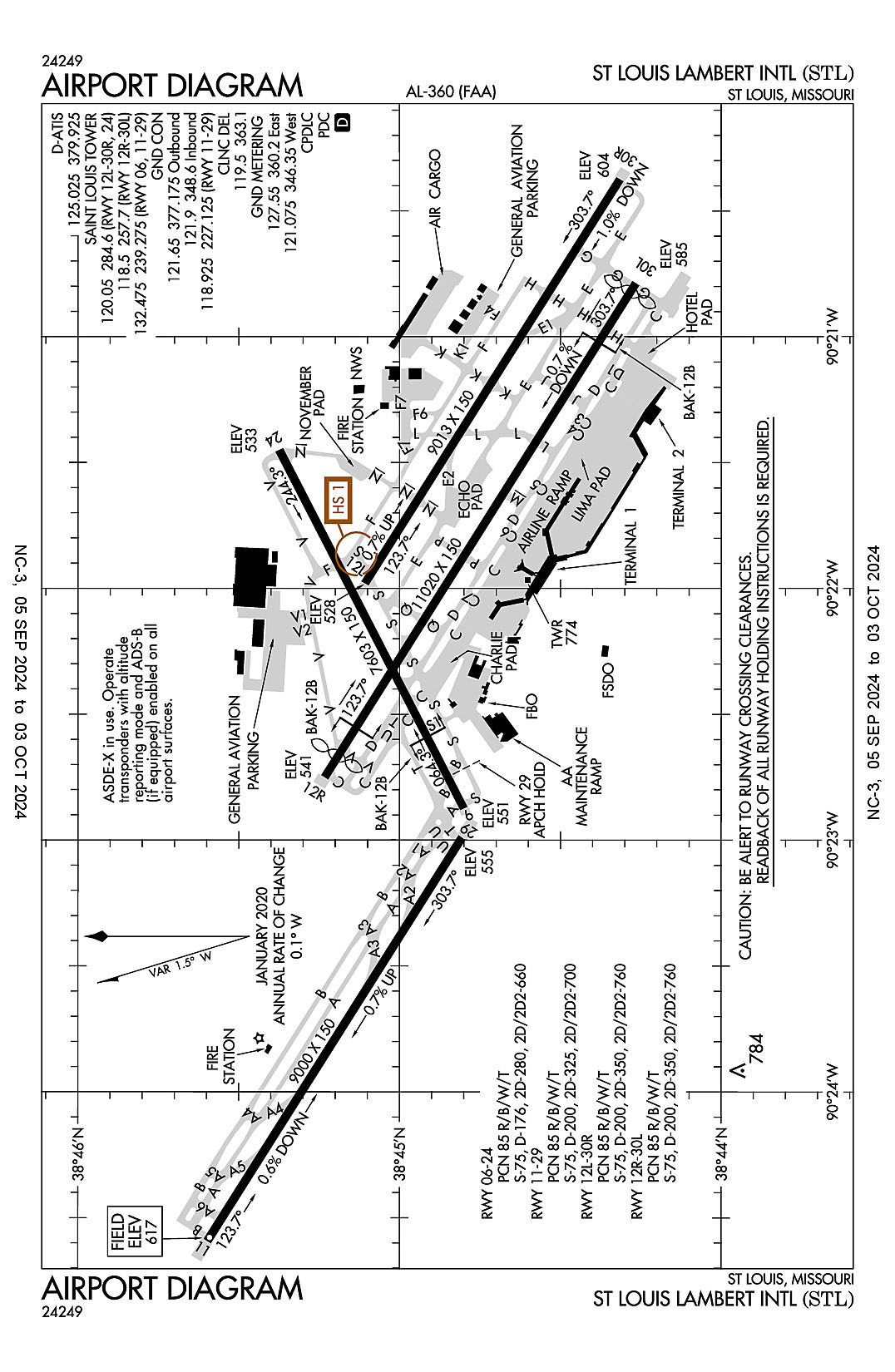
St. Louis, Missouri
Lambert-St. Louis International
ICAO Identifier KSTL
St Louis, MO
Lambert-St Louis Intl
ICAO Identifier KSTL
AD 2.2 Aerodrome Geographical and Administrative Data
2.2.1 Reference Point: 38-44-55.3136N / 90-22-12.0926W
2.2.2 From City: 10 miles NW of ST LOUIS, MO
2.2.3 Elevation: 617.3 ft
2.2.5 Magnetic Variation: 1W (2020)
2.2.6 Airport Contact: MS. RHONDA HAMM-NIEBRUEGGE
BOX 10212
ST LOUIS, MO 63145 (314-426-8000)
2.2.7 Traffic: IFR/VFR
AD 2.3 Attendance Schedule
2.3.1 All Months, All Days, All Hours
AD 2.4 Handling Services and Facilities
2.4.1 Cargo Handling Facilities: YES
2.4.2 Fuel Types: 100LL A
2.4.5 Hangar Space: YES
2.4.6 Repair Facilities: MAJOR
AD 2.6 Rescue and Firefighting Services
2.6.1 Aerodrome Category: Class-I certified on 5/1/1973
2.6.2 Rescue and Firefighting Services: ARFF Index-D
AD 2.12 Runway Physical Characteristics
2.12.1 Designation: 06
2.12.2 True Bearing: 63
2.12.3 True Dimensions: 7603 ft x 150 ft
2.12.4 PCN: 85 R/B/W/T
2.12.5 Coordinates: 38-44-48.0621N / 90-22-52.3834W
2.12.6 Threshold Elevation: 550.6
2.12.6 Touchdown Zone Elevation: 550.9
2.12.1 Designation: 24
2.12.2 True Bearing: 243
2.12.3 True Dimensions: 7603 ft x 150 ft
2.12.4 PCN: 85 R/B/W/T
2.12.5 Coordinates: 38-45-22.3829N / 90-21-27.014W
2.12.6 Threshold Elevation: 533.2
2.12.6 Touchdown Zone Elevation: 533.7
2.12.1 Designation: 11
2.12.2 True Bearing: 122
2.12.3 True Dimensions: 9000 ft x 150 ft
2.12.4 PCN: 85 R/B/W/T
2.12.5 Coordinates: 38-45-35.8282N / 90-24-35.5403W
2.12.6 Threshold Elevation: 616.8
2.12.6 Touchdown Zone Elevation: 617.3
2.12.1 Designation: 29
2.12.2 True Bearing: 302
2.12.3 True Dimensions: 9000 ft x 150 ft
2.12.4 PCN: 85 R/B/W/T
2.12.5 Coordinates: 38-44-48.4521N / 90-22-59.3854W
2.12.6 Threshold Elevation: 555.2
2.12.6 Touchdown Zone Elevation: 579.6
2.12.1 Designation: 30R
2.12.2 True Bearing: 302
2.12.3 True Dimensions: 9013 ft x 150 ft
2.12.4 PCN: 85 R/B/W/T
2.12.5 Coordinates: 38-44-18.9859N / 90-20-22.5077W
2.12.6 Threshold Elevation: 604.3
2.12.6 Touchdown Zone Elevation: 604.5
2.12.1 Designation: 12L
2.12.2 True Bearing: 122
2.12.3 True Dimensions: 9013 ft x 150 ft
2.12.4 PCN: 85 R/B/W/T
2.12.5 Coordinates: 38-45-06.4559N / 90-21-58.7582W
2.12.6 Threshold Elevation: 527.7
2.12.6 Touchdown Zone Elevation: 540.6
2.12.1 Designation: 30L
2.12.2 True Bearing: 302
2.12.3 True Dimensions: 11020 ft x 150 ft
2.12.4 PCN: 85 R/B/W/T
2.12.5 Coordinates: 38-44-16.0145N / 90-20-47.272W
2.12.6 Threshold Elevation: 585.3
2.12.6 Touchdown Zone Elevation: 582.5
2.12.1 Designation: 12R
2.12.2 True Bearing: 122
2.12.3 True Dimensions: 11020 ft x 150 ft
2.12.4 PCN: 85 R/B/W/T
2.12.5 Coordinates: 38-45-14.0539N / 90-22-44.9719W
2.12.6 Threshold Elevation: 541.3
2.12.6 Touchdown Zone Elevation: 539.7
AD 2.13 Declared Distances
2.13.1 Designation: 06
2.13.2 Take-off Run Available: 7603
2.13.3 Take-off Distance Available: 7603
2.13.4 Accelerate-Stop Distance Available: 7323
2.13.5 Landing Distance Available: 7323
2.13.1 Designation: 24
2.13.2 Take-off Run Available: 7603
2.13.3 Take-off Distance Available: 7603
2.13.4 Accelerate-Stop Distance Available: 7603
2.13.5 Landing Distance Available: 7603
2.13.1 Designation: 11
2.13.2 Take-off Run Available: 9000
2.13.3 Take-off Distance Available: 9000
2.13.4 Accelerate-Stop Distance Available: 9000
2.13.5 Landing Distance Available: 9000
2.13.1 Designation: 29
2.13.2 Take-off Run Available: 9000
2.13.3 Take-off Distance Available: 9000
2.13.4 Accelerate-Stop Distance Available: 9000
2.13.5 Landing Distance Available: 9000
2.13.1 Designation: 30R
2.13.2 Take-off Run Available: 9013
2.13.3 Take-off Distance Available: 9013
2.13.4 Accelerate-Stop Distance Available: 9013
2.13.5 Landing Distance Available: 9013
2.13.1 Designation: 12L
2.13.2 Take-off Run Available: 9013
2.13.3 Take-off Distance Available: 9013
2.13.4 Accelerate-Stop Distance Available: 8956
2.13.5 Landing Distance Available: 8956
2.13.1 Designation: 30L
2.13.2 Take-off Run Available: 11020
2.13.3 Take-off Distance Available: 11020
2.13.4 Accelerate-Stop Distance Available: 10880
2.13.5 Landing Distance Available: 10679
2.13.1 Designation: 12R
2.13.2 Take-off Run Available: 11020
2.13.3 Take-off Distance Available: 11020
2.13.4 Accelerate-Stop Distance Available: 11020
2.13.5 Landing Distance Available: 10553
AD 2.14 Approach and Runway Lighting
2.14.1 Designation: 06
2.14.2 Approach Lighting System: MALSR
2.14.4 Visual Approach Slope Indicator System: P4R
2.14.1 Designation: 24
2.14.2 Approach Lighting System: MALS
2.14.4 Visual Approach Slope Indicator System: P4L
2.14.1 Designation: 11
2.14.2 Approach Lighting System: ALSF2
2.14.4 Visual Approach Slope Indicator System: P4R
2.14.1 Designation: 29
2.14.2 Approach Lighting System: ALSF2
2.14.4 Visual Approach Slope Indicator System: P4L
2.14.1 Designation: 30R
2.14.2 Approach Lighting System: ALSF2
2.14.4 Visual Approach Slope Indicator System: P4R
2.14.1 Designation: 12L
2.14.2 Approach Lighting System: ALSF2
2.14.4 Visual Approach Slope Indicator System: P4R
2.14.1 Designation: 30L
2.14.2 Approach Lighting System: MALSR
2.14.4 Visual Approach Slope Indicator System: P4R
2.14.1 Designation: 12R
2.14.2 Approach Lighting System: MALSR
2.14.4 Visual Approach Slope Indicator System: P4L
AD 2.18 Air Traffic Services Communication Facilities
2.18.1 Service Designation: CD/P
2.18.3 Channel: 119.5
2.18.5 Hours of Operation: 24
2.18.1 Service Designation: CD/P
2.18.3 Channel: 363.1
2.18.5 Hours of Operation: 24
2.18.1 Service Designation: D-ATIS
2.18.3 Channel: 125.025
2.18.5 Hours of Operation: 24
2.18.1 Service Designation: D-ATIS
2.18.3 Channel: 379.925
2.18.5 Hours of Operation: 24
2.18.1 Service Designation: EMERG
2.18.3 Channel: 121.5
2.18.5 Hours of Operation:
2.18.1 Service Designation: EMERG
2.18.3 Channel: 243
2.18.5 Hours of Operation:
2.18.1 Service Designation: GND METERING (WEST)
2.18.3 Channel: 121.075
2.18.5 Hours of Operation: 24
2.18.1 Service Designation: GND METERING (EAST)
2.18.3 Channel: 127.55
2.18.5 Hours of Operation: 24
2.18.1 Service Designation: GND METERING (WEST)
2.18.3 Channel: 346.35
2.18.5 Hours of Operation: 24
2.18.1 Service Designation: GND METERING (EAST)
2.18.3 Channel: 360.2
2.18.5 Hours of Operation: 24
2.18.1 Service Designation: GND/P (RWY 11/29)
2.18.3 Channel: 118.925
2.18.5 Hours of Operation: 24
2.18.1 Service Designation: GND/P (OUTBOUND)
2.18.3 Channel: 121.65
2.18.5 Hours of Operation: 24
2.18.1 Service Designation: GND/P (INBOUND)
2.18.3 Channel: 121.9
2.18.5 Hours of Operation: 24
2.18.1 Service Designation: GND/P (RWY 11/29)
2.18.3 Channel: 227.125
2.18.5 Hours of Operation: 24
2.18.1 Service Designation: GND/P (INBOUND)
2.18.3 Channel: 348.6
2.18.5 Hours of Operation: 24
2.18.1 Service Designation: GND/P (OUTBOUND)
2.18.3 Channel: 377.175
2.18.5 Hours of Operation: 24
2.18.1 Service Designation: LCL/P (RWY 12R/30L)
2.18.3 Channel: 118.5
2.18.5 Hours of Operation: 24
2.18.1 Service Designation: LCL/P (RWY 12L/30R, 24)
2.18.3 Channel: 120.05
2.18.5 Hours of Operation: 24
2.18.1 Service Designation: LCL/P (RWY 06, 11/29)
2.18.3 Channel: 132.475
2.18.5 Hours of Operation: 24
2.18.1 Service Designation: LCL/P (RWY 06, 11/29)
2.18.3 Channel: 239.275
2.18.5 Hours of Operation: 24
2.18.1 Service Designation: LCL/P (RWY 12R/30L)
2.18.3 Channel: 257.7
2.18.5 Hours of Operation: 24
2.18.1 Service Designation: LCL/P (RWY 12L/30R, 24)
2.18.3 Channel: 284.6
2.18.5 Hours of Operation: 24
2.18.1 Service Designation: PRM (RWY 30R)
2.18.3 Channel: 278.3
2.18.5 Hours of Operation: 24
2.18.1 Service Designation: PRM (RWY 30L)
2.18.3 Channel: 351.9
2.18.5 Hours of Operation: 24
AD 2.19 Radio Navigation and Landing Aids
2.19.1 ILS Type: DME for runway 06. Magnetic variation: 1W
2.19.2 ILS Identification: JAK
2.19.5 Coordinates: 38-44-40.533N / 90-22-58.4278W
2.19.6 Site Elevation: 555.1 ft
2.19.1 ILS Type: Glide Slop for runway 06. Magnetic variation: 1W
2.19.2 ILS Identification: JAK
2.19.5 Coordinates: 38-44-54.582N / 90-22-40.1291W
2.19.6 Site Elevation: 537.6 ft
2.19.1 ILS Type: Localizer for runway 06. Magnetic variation: 1W
2.19.2 ILS Identification: JAK
2.19.5 Coordinates: 38-45-27.2803N / 90-21-14.821W
2.19.6 Site Elevation: 547.5 ft
2.19.1 ILS Type: DME for runway 24. Magnetic variation: 1W
2.19.2 ILS Identification: STL
2.19.5 Coordinates: 38-44-40.533N / 90-22-58.4278W
2.19.6 Site Elevation: 555.1 ft
2.19.1 ILS Type: Glide Slop for runway 24. Magnetic variation: 1W
2.19.2 ILS Identification: STL
2.19.5 Coordinates: 38-45-13.5951N / 90-21-37.573W
2.19.6 Site Elevation: 528.6 ft
2.19.1 ILS Type: Localizer for runway 24. Magnetic variation: 1W
2.19.2 ILS Identification: STL
2.19.5 Coordinates: 38-44-43.5036N / 90-23-03.7184W
2.19.6 Site Elevation: 545.7 ft
2.19.1 ILS Type: DME for runway 11. Magnetic variation: 1W
2.19.2 ILS Identification: OGZ
2.19.5 Coordinates: 38-44-36.5929N / 90-22-41.4734W
2.19.6 Site Elevation: 562.6 ft
2.19.1 ILS Type: Glide Slop for runway 11. Magnetic variation: 1W
2.19.2 ILS Identification: OGZ
2.19.5 Coordinates: 38-45-26.0348N / 90-24-25.3788W
2.19.6 Site Elevation: 598.2 ft
2.19.1 ILS Type: Inner Marker for runway 11. Magnetic variation: 1W
2.19.2 ILS Identification: OGZ
2.19.5 Coordinates: 38-45-40.3474N / 90-24-44.7374W
2.19.6 Site Elevation: 613.3 ft
2.19.1 ILS Type: Localizer for runway 11. Magnetic variation: 1W
2.19.2 ILS Identification: OGZ
2.19.5 Coordinates: 38-44-38.7168N / 90-22-39.6283W
2.19.6 Site Elevation: 544.8 ft
2.19.1 ILS Type: DME for runway 29. Magnetic variation: 1W
2.19.2 ILS Identification: RQN
2.19.5 Coordinates: 38-45-43.8773N / 90-24-45.2373W
2.19.6 Site Elevation: 628 ft
2.19.1 ILS Type: Glide Slop for runway 29. Magnetic variation: 1W
2.19.2 ILS Identification: RQN
2.19.5 Coordinates: 38-44-49.8126N / 90-23-11.853W
2.19.6 Site Elevation: 555.6 ft
2.19.1 ILS Type: Localizer for runway 29. Magnetic variation: 1W
2.19.2 ILS Identification: RQN
2.19.5 Coordinates: 38-45-41.3528N / 90-24-46.7635W
2.19.6 Site Elevation: 612.3 ft
2.19.1 ILS Type: DME for runway 12L. Magnetic variation: 1W
2.19.2 ILS Identification: LDZ
2.19.5 Coordinates: 38-44-10.3827N / 90-20-12.0493W
2.19.6 Site Elevation: 614.1 ft
2.19.1 ILS Type: Glide Slop for runway 12L. Magnetic variation: 1W
2.19.2 ILS Identification: LDZ
2.19.5 Coordinates: 38-44-58.2183N / 90-21-50.3412W
2.19.6 Site Elevation: 533.8 ft
2.19.1 ILS Type: Inner Marker for runway 12L. Magnetic variation: 1W
2.19.2 ILS Identification: LDZ
2.19.5 Coordinates: 38-45-11.9417N / 90-22-09.8845W
2.19.6 Site Elevation: 531.1 ft
2.19.1 ILS Type: Localizer for runway 12L. Magnetic variation: 1W
2.19.2 ILS Identification: LDZ
2.19.5 Coordinates: 38-44-13.6664N / 90-20-11.7277W
2.19.6 Site Elevation: 601.7 ft
2.19.1 ILS Type: DME for runway 30R. Magnetic variation: 1W
2.19.2 ILS Identification: SJW
2.19.5 Coordinates: 38-45-14.1233N / 90-22-07.9077W
2.19.6 Site Elevation: 541 ft
2.19.1 ILS Type: Glide Slop for runway 30R. Magnetic variation: 1W
2.19.2 ILS Identification: SJW
2.19.5 Coordinates: 38-44-21.9637N / 90-20-38.0149W
2.19.6 Site Elevation: 592.5 ft
2.19.1 ILS Type: Inner Marker for runway 30R. Magnetic variation: 1W
2.19.2 ILS Identification: SJW
2.19.5 Coordinates: 38-44-14.6573N / 90-20-13.7268W
2.19.6 Site Elevation: 600.9 ft
2.19.1 ILS Type: Localizer for runway 30R. Magnetic variation: 1W
2.19.2 ILS Identification: SJW
2.19.5 Coordinates: 38-45-12.1188N / 90-22-10.2369W
2.19.6 Site Elevation: 531.7 ft
2.19.1 ILS Type: DME for runway 12R. Magnetic variation: 1W
2.19.2 ILS Identification: LMR
2.19.5 Coordinates: 38-44-07.6656N / 90-20-39.8597W
2.19.6 Site Elevation: 606.5 ft
2.19.1 ILS Type: Glide Slop for runway 12R. Magnetic variation: 1W
2.19.2 ILS Identification: LMR
2.19.5 Coordinates: 38-45-08.9361N / 90-22-24.8753W
2.19.6 Site Elevation: 532 ft
2.19.1 ILS Type: Localizer for runway 12R. Magnetic variation: 1W
2.19.2 ILS Identification: LMR
2.19.5 Coordinates: 38-44-10.2182N / 90-20-35.5392W
2.19.6 Site Elevation: 595.6 ft
2.19.1 ILS Type: Glide Slop for runway 30L. Magnetic variation: 1W
2.19.2 ILS Identification: BKY
2.19.5 Coordinates: 38-44-28.0656N / 90-21-01.7914W
2.19.6 Site Elevation: 564.5 ft
2.19.1 ILS Type: Localizer for runway 30L. Magnetic variation: 1W
2.19.2 ILS Identification: BKY
2.19.5 Coordinates: 38-45-19.3841N / 90-22-55.7958W
2.19.6 Site Elevation: 550.8 ft
2.19.1 Navigation Aid Type VORTAC. Magnetic variation: 1E
2.19.2 Navigation Aid Identification: STL
2.19.5 Coordinates: 38-51-38.6039N / 90-28-56.456W
2.19.6 Site Elevation: 445.5 ft
General Remarks:
TWY DELTA OR TAXILANE CHARLIE FM TWY SIERRA TO TWY GOLF, B-747S ARE NOT AUTH TO PASS OR BE PASSED BY B767 OR OTR LRGR ACFT OPRG ON THE PARL TWY/TAXILANE.
TWY CHARLIE, FROM TWY CHARLIE SIX TO TWY DELTA FOUR, RSTRD TO B757-300 SERIES OR SMLR WHEN PASSING BHND ACFT THAT HAVE MADE THE INITIAL 10 FT PUSHBACK.
TWY ALPHA EAST OF TWY TANGO, TWY SIERRA AND RWY 6/24 SOUTH OF TWY BRAVO, NO ACFT OR VEHICLE OPNS WHEN ARRIVING OR DEPG RWY 11 OR ARRIVING RWY 29.
TWY LIMA, NORTH OF RWY 12L/30R, ACFT LRGR THAN A GULFSTREAM VI TAX NBND ARE PROHIBITED FM MAKING A RIGHT TURN EBND ON TWY FOXTROT.
TWY KILO 1 IS UNAVBL TO B-767 OR LRGR ACFT (WINGSPAN 118 FT OR GTR).
TWY ECHO, BTN TWY NOVEMBER AND TWY LIMA RSTRD TO B-767 OR SMLR ACFT (WINGSPAN LESS THAN 171 FT) WHEN ACFT ARE PARKED ON THE ECHO PAD.
TWY CHARLIE, FROM TWY CHARLIE SEVEN TO TWY CHARLIE SIX, RSTRD TO A B757-300 SERIES OR SMLR.
TWY VICTOR 2 IS UNAVBL TO B-767 OR LRGR ACFT (WINGSPAN 118 FT OR GTR).
WAIVER TO CONDUCT SIMUL APCHS TO PARL RYS SEPARATED BY 1,300 FT IN EFCT.
WG TIP CLNC WITH GND VEH NOT ADQT ALG N SIDE OF MAIN TRML APN.
TWY NOVEMBER BTN RWY 24 AND FOXTROT, RSTRD TO ACFT WITH A WINGSPAN OF LESS THAN 79 FT (CRJ-900 OR SMLR) WHEN ACFT ARE PARKED ON THE NOVEMBER PAD. THIS AREA IS RSTRD TO ALL OPNS WHEN ACFT ARE PERFORMING END RUN-UPS IN THE NOVEMBER PAD.
TWY VICTOR, UNDERLYING THE RWY 12L FNA CRS, IS RSTRD TO ACFT WITH A TAIL HGT OF 25 FT OR LESS (CRJ-700 OR SMLR) WHEN ACFT ARE LNDG ON RWY 12L.
TWY CHARLIE, FM TWY SIERRA TO TWY CHARLIE SEVEN, RSTRD TO B-767 OR SMLR ACFT (156 FT AVBL) WHEN ACFT ARE PARKED IN THE CHARLIE PAD. RSTRN IS FOR TAX ACFT, LRGR ACFT MAY BE TOWED THRU AREA.
TWY CHARLIE, EAST OF TWY DELTA ONE TO THE AER 30L, RSTRD TO B-737 OR SMLR ACFT (WINGSPAN LESS THAN 118 FT) WHEN ACFT ARE PARKED ON THE HOTEL PAD.
A-GEAR: A-G ARE KEPT IN RECESSED POSN TIL REQ FOR USE. TWR MUST BE NOTIFIED AT LEAST 5 SEC PRIOR TO ENGAGEMENT SO THAT CABLE MAY BE RAISED.
TWY VICTOR 2, B-737 (WINGSPAN GTR THAN 79 FT BUT LESS THAN 118 FT) MUST PERFORM JUDGMENTAL OVERSTEERING INSTEAD OF COCKPIT OVR CNTRLN STEERING WHEN TAX.